Tropical Storm Sara Forms Near Honduras
11/14/25 – At 1 PM EST, the National Hurricane Center (NHC) began issuing advisories on Tropical Storm Sara, the 19th named storm of the Atlantic Hurricane season. It formed in the western Caribbean near the border between Nicaragua and Honduras.

Circulation and banding appeared on satellite images taken this morning. The storm currently has sustained winds of 40 MPH and a forward speed of 12 MPH. Some strengthening is possible if the storm remains over water.
Life-Threatening Flash Flooding and Mudslides
Be aware in case you have relatives in Central America or travel planned there.
NHC predicts life-threatening and potentially catastrophic flash flooding and mudslides through the weekend.
National Hurricane Center
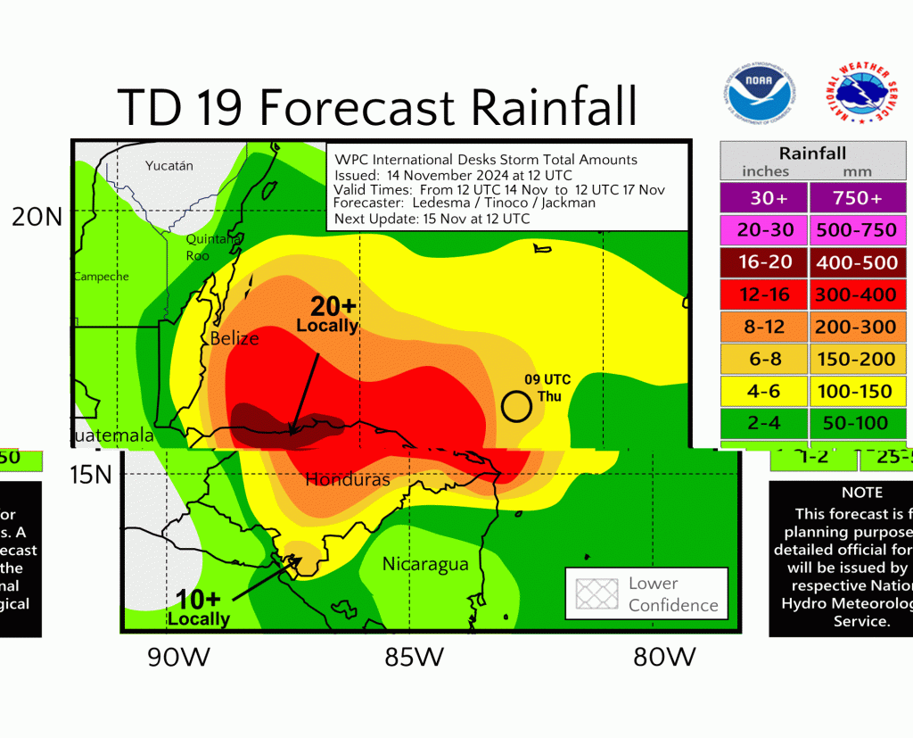
The system will likely meander in the Bay of Honduras for the next several days, dropping 10-20″ inches of rain, with isolated totals up to 30″.
Mountains border that northern coast of Honduras where the heaviest rain will fall.

Simultaneously, storm surge and large, destructive waves will rake the northern coast of Honduras for several days.
Track Still Uncertain
The track and intensity for Tropical Storm Sara are still somewhat uncertain. That big, empty area in the satellite photo above is a high-pressure ridge, much like the one that protected Houston from Rafael earlier this month.
But the high pressure will break down early next week ahead of an approaching low-pressure system. That could turn Tropical Storm Sara northwest and north-northwest into the southern Gulf of Mexico.

In the meantime, land interaction could also weaken the system.
According to Harris County Meteorologist Jeff Lindner, “It is possible that the system moves inland over portions of central America or the Yucatan and dissipates.”
Intensity Forecasts Lowered
While Tropical Storm Sara will encounter favorable conditions over water, the interaction with Honduras will likely limit the upper-end potential of the storm over the next 4-5 days, says Lindner.
Should Sara reach the southern Gulf of Mexico, a powerful frontal system moving off the Texas coast early next week will likely produce wind sheer that weakens the storm further.
“No Threat to Texas Coast”
Lindner concluded, “With a strong, deep-layer trough and front moving into the southern plains early next week, this system poses no threat to the Texas coast.”
However, NHC warns Gulf Coast residents to regularly monitor updates through mid-week next week.

On a personal note, I used to scuba dive regularly in Honduras. The country is beautiful. But the terrain along the northern coast is steep and rugged. And building codes are not up to U.S. standards.
Twenty inches of rain could easily devastate the area. So, keep the folks there in your prayers.
Posted by Bob Rehak on 11/14/24
2634 Days since Hurricane Harvey


