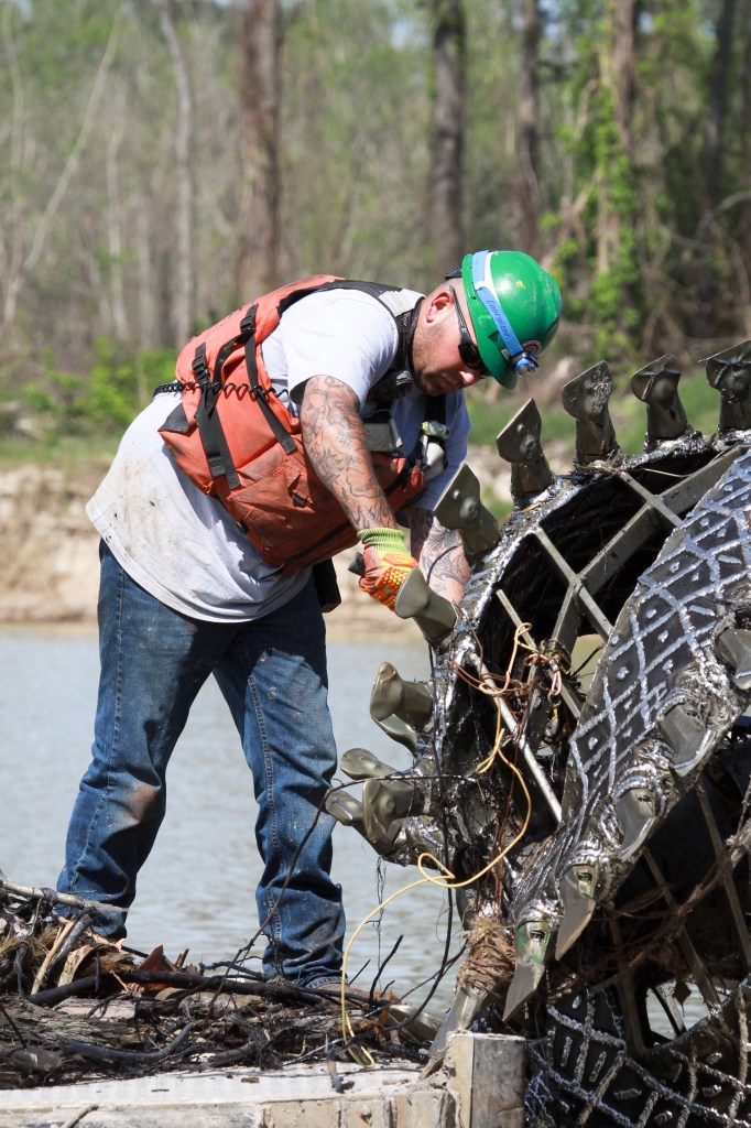
Photo of the Day #293


Since last September, the Army Corps of Engineers has had two contractors, each with approximately 30 people, working 24/7 on the the West Fork of the San Jacinto.
Together, they’re removing approximately 1.9 million cubic yards of sediment left behind by Hurricane Harvey that is blocking the conveyance of the river. It’s hard to move that much sand and silt without getting your hands dirty, as these pictures by the Army Corps clearly demonstrate.
One crew started at River Grove and is working downstream toward the mid-point of a 2.1 mile stretch of the West Fork. The other started at the mid-point and is working downstream toward where Ben’s Branch enters the river, just past Kings Harbor.


Corps Engineers said that since Sept. 20, 2018, approximately 1.4 million cubic yards of Hurricane Harvey silt and debris have been pumped into the two placement areas. Ultimately, they expect to pump approximately 1.8 -1.9 million cubic yards to meet FEMA requirements, restore the river to pre-Harvey conditions, and to reduce flood risks.
These images illustrate why boaters should stay away from the West Fork for now. It’s not safe. The FEMA funded emergency flood action should complete in early May, 2019.
Posted by Bob Rehak on 4/3/2019 with images courtesy of the Army Corps of Engineers
582 Days since Hurricane Harvey
The US Army Corps of Engineers has just released a graphic that updates the Lake Houston Community on West Fork dredging progress. With a little more than two months to go before the scheduled completion of the project, about two thirds of the work has been completed. That’s a visual estimate, not one based on volume of sand removed.
The clock started ticking on this project on July 15, 2018. The contract called for completion in 270 days or about mid-April. However, contractors encountered three back-to-back-to-back floods in December and January that set them back. The Corps’ last scheduled completion date was at the end of April.
The dredging progress may be slightly behind schedule, even given the addition of the “weather days.” However, contractors hope to make up the time as weather improves.

To download a high-resolution version of this progress map, click here.
Artwork courtesy of the U.S. Army Corps of Engineers.
Posted by Bob Rehak on 2/21/2019
541 Days since Hurricane Harvey
According to Stephen Costello, Chief Resiliency Officer for The City of Houston, the City contracted with a company called Tetra Tech to take core samples earlier this week from and around the mouth bar on the West Fork of the San Jacinto.
The mouth bar is a giant sand bar at the mouth of the river where it meets the lake. The size of it has concerned residents throughout the Lake Houston Area since Harvey. It has the potential to back water up on both sides of the river and worsen flooding.
Some background. The Army Corps initially excluded the mouth bar from its current dredging program on the west fork. Their reason: a small part of the bar existed before Harvey. FEMA, which is funding the dredging, by law cannot spend money on remediation for things that existed before the disaster in question.
It took months for the City, FEMA and the Army Corps to agree on a way to estimate the volume of sand deposited by Harvey. The answer says Costello: something called the Stockton protocol that he says was developed after Superstorm Sandy at Stockton University in New Jersey.
The core samples will be key to estimating pre- and post-Harvey volumes. Costello says engineers will look at density and color of sand grains to help estimate where sediment from one storm stops and another starts.
Costello hopes engineers will complete their analysis by the end of February. In the meantime two other efforts are proceeding simultaneously.
The Corps will evaluate one property for suitability as above-ground storage. Separately, others are also out looking at sub-surface storage sites (i.e., old sand pits). Several have been located. The cost and safety of above ground and below ground storage will be weighed against the possibility of hauling material off by truck. Distance between the dredge and disposal sites also affects pumping costs.
All this will take time, especially if a full-blown environmental study is necessary for the above-ground option. Costello says the Corps has told him that could take four months to two years.
Because of delays, Costello is starting to worry that delays may cost taxpayers the opportunity to save $18 million. That’s the cost to remobilize a second dredging project if the current dredging project cannot be extended.
Accordingly, Costello is pursuing two options. The first involves praying (that’s a joke). The second involves working back through the Texas Division of Emergency Management to get FEMA to declare the mouth bar part of the original emergency mission. The Corps seems to move much faster when orders come from FEMA, several sources tell me. Maybe we should start praying too. (That’s not a joke.)
Money, according to Costello, should not be a problem. FEMA has approved the use of debris cleanup money from Harvey for dredging. He believes enough money remains in that fund to cover the City’s cost share.
The Corps estimates that the current dredging project is 45% complete. They hope to complete dredging by the end of April.


Posted by Bob Rehak on February 7, 2018
527 Days since Hurricane Harvey
Note: This post contains a correction to Matt Zeve’s title; he is Deputy Executive Director at Harris County Flood Control.
The Army Corps of Engineers today released this graphic showing the extent of West Fork dredging progress to date. Dredging will extend from River Grove Park on the west King’s Harbor on the east.

The Corps expected the project to take 270 days or 9 months. The clock started ticking on July 21, 2018, when the Corps awarded the job to Great Lakes Dredge and Dock and its subcontractor Callan Marine.
Great Lakes subcontracted part of the job because it was time sensitive and Callan had a dredge that could start quickly. In fact, Callan began sooner than Great Lakes. Both companies spent considerable time on site assembling the dredges. Welding more than six miles of 24 inch HDPE dredge pipe and maneuvering it into place also required upfront time. Then both companies had to calibrate dredging rates with three booster pumps. Make no mistake; this is a huge undertaking.
Two months after the contract award, the first dredge moved downriver to its starting position on September 19th. A month later, on October 25th, the second dredge moved downriver. So out of the the 9 months, it took two and three months respectively just to start the dredging. Then we had three floods between December 7 and January 7 that caused pauses in the action.
Backing out floods and prep time, we need to evaluate the progress shown above on a SIX month “actual-dredging” timetable, not the nine months budgeted for the entire job. Visually, it appears that they are roughly half completed and roughly half of the six months has expired. That’s reassuring. Especially knowing that the dredging has proved more difficult than expected. Crews periodically must stop to remove roots and aquatic vegetation from the dredge cutter heads.
The questions readers keep asking, though, are “Will we be able to save all of that investment in upfront time?” And “Will we be able to start dredging the mouth bar before the start of next hurricane season starts on June 1?”
Corps bids showed that mobilization and demobilization cost 25% of the total job, roughly $18 million. Starting the mouth bar project as soon as the current project completes could save that money. It’s enough to do a lot more dredging. Maybe even open up the boat launch that the County hopes to build at its new Edgewater Park near US 59.
Dan Crenshaw, the Lake Houston Area’s new US Congressman seems to be jumping into flooding issues with both feet. He announced today that he has been appointed to Congressional Budget and Homeland Security committees. The budget committee assignment should put him in a good position to help accelerate flood mitigation measures.
Crenshaw has already met with Harris County with Flood Control District Deputy Executive Director Matt Zeve and Professional Engineer Ian Hudson to get an update on projects in Texas’s Second Congressional District. Those include both cleanup projects and flood mitigation projects. Crenshaw also met on Monday with Houston City Councilman Dave Martin, in which they discussed the importance of these projects. I also hear he is meeting the Army Corps and developers of the new high-rise project proposed for Kingwood.

Said Crenshaw, “Our district has been through so much because of Hurricane Harvey. I’m grateful for all the hard work our local and federal officials have done to prepare us for the next storm. I’m excited to get to work to ensure the people of TX-02 are able to make a full recovery and put Harvey in the rearview mirror.”
Something tells me that Crenshaw will bring the zeal of a SEAL to this job.
Posted on January 23, 2019 by Bob Rehak
512 days since Hurricane Harvey
The rain overnight became pretty intense between 4:30 and 5:30 a.m. about the time the NWS issued a tornado watch. Once again, areas north and northwest of us received more rain that we did. The NWS has issued a flood warnings for the West Fork of the San Jacinto. West Fork. They expect the river to crest at 51.3 feet, well below the major classification.
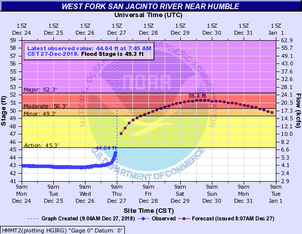
The River should rise above flood stage Friday morning and crest on Sunday. The flood will impact low lying roads near the river. The north side turnaround at US 59 and low points on Thelma Rd, Aqua Vista Dr, and Riverview Dr. will begin to flood. Water levels should approximate those reached in the December 7-8, 2018 event. Nearly all of the water heading into the West Fork is from significant run-off being generated on Cypress, Spring, and Lake Creeks.
The City did not lower Lake Houston in anticipation of this flood. However, the Coastal Water Authority is currently releasing 2500 cubic feet per second through the tainter gates on Lake Houston. It will be interesting to compare the ultimate water height to the Dec. 7-8 flood when the City did lower the Lake.
Here’s what the dock at River Grove looked like this morning. Photo courtesy of Bruce Casto.

On December 8, River Grove looked like this.

East Fork residents can breath a little easier.

River is already rising at FM 1485 and nearing bankfull at FM 2090 (Plum Grove). Heavy rainfall over the headwaters of the river will move downstream from the Cleveland area and reach Plum Grove and FM 1485 this weekend. The river should rise to flood stage midday Friday and have an extended flat crest over the weekend near 60.5 ft. FM 1485 may be threatened at these levels along with low lying roads in subdivisions downstream of FM 1485. That’s Huffman and Kingwood!
Significant run-off is in progress over the upper headwaters of Spring Creek and the creek is rising along the entire channel. Hegar Rd is at bankfull this morning and near bankfull conditions will be possible along the creek downstream to SH 249 and I-45. No structure flooding is expected, but some low lying roads near the creek or that cross the creek may be impacted…especially upstream of SH 249.
Significant run-off in the headwaters into Cypress Creek. Creek may reach near flood stage later today at Katy Hockley. Harris County Flood Control does not expect any significant downstream flooding east of Hwy 290 along Cypress Creek, although the creek will be very high as upstream water moves downstream.
Posted on 12/27/18 by Bob Rehak
485 Days since Hurricane Harvey
On Thursday, October 11, Council Member Dave Martin attended a follow up meeting to discuss Harvey recovery needs in the Lake Houston area, including the mouth bar. Regulatory agencies including the Texas Department of Emergency Management (TDEM), the Federal Emergency Management Agency (FEMA), the U.S. Army Corps of Engineers (USACE), along with staff from Texas Governor Greg Abbott’s office and the City of Houston also attended the meeting. At one point, Texas Division of Emergency Management Chief Nim Kidd reportedly told people he wasn’t going to let them leave until they reached agreement. The meeting lasted nine hours…without lunch. But at the end of the day, we’re a big step closer to removing the giant sand bar blocking the mouth of the San Jacinto River. Here’s how things reportedly played out.
The City of Houston asked FEMA to give the U.S. Army Corps of Engineers (USACE) an emergency directive to remove siltation caused by Hurricane Harvey at the mouth of the West Fork of the San Jacinto. Further, to expedite the project and save remobilization fees, the City requested that this work piggyback on the original State of Texas Assistance Request (STAR).
Although not officially approved yet, regulatory agencies reacted favorably to adding this to the original STAR request. However, two hurdles still exist.
Before the mouth bar can be removed, two more hurdles must be cleared:
TDEM agreed to complete this additional work under an emergency request similar to the one that jumpstarted the initial dredging.
Said Houston City Council Member Dave Martin, “All parties involved are ready to make this work.”
Barry Madden, an Humble landowner, with substantial acreage near the river and the mouth bar, has already met with officials about using his property as a potential disposal site. If acceptable, the proximity could save millions of tax dollars. Madden already has “fill” permits in place. So there may really only be one hurdle to clear.

Property owned by Barry Madden just west of Kings Lake Estates and south of the San Jacinto West Fork
As discussed at the Kingwood Town Hall Meeting on Tuesday, October 9, this mouth bar and other Lake Houston area projects could not happen without the continuing efforts of TDEM, in particular Chief W. Nim Kidd; Governor Abbott’s Chief Operating Officer, Reed Clay; City of Houston, Mayor Sylvester Turner; Chief Resiliency Officer, Stephen Costello; and Chief Recovery Officer, Marvin Odum.
Many residents continue to ask Council Member Martin what they can do to help. Council Member Martin encourages residents to send their thanks to several key officials for assisting District E. Please click here for their mailing addresses.
For more information, please contact Council Member Martin’s office at (832) 393-3008 or via email at districte@houstontx.gov.
Posted by Bob Rehak on 10/12/18
409 Days since Hurricane Harvey
In the last two days, several people have reported dredging near the US59 Bridge. What they actually saw, however, was not a dredge; it was dredge pipe, booster pumps and other related equipment being positioned to pump spoils to Placement Area #2, the Eagle Mine just south of Kingwood College on Sorters Road.
Here’s where things stand a little more than two weeks since the launch of the first dredge on August 20, 2018.
Both the Army Corps and Council Member Dave Martin swear that the scope of the project has not changed. The original scope covered approximately 2.1 miles of the West Fork from River Grove Park to Chimichurri’s just east of the West Lake Houston Parkway Bridge.

Illustration from US Army Corps’ contract plans for West Fork Dredging showing project scope.
Some confusion arose over that when the first dredge anchored WEST of the West Lake Houston Parkway Bridge for almost two weeks. The dredge anchored near the overhead electrical lines in the middle of section C-102.
Last week, the Corps continued to position dredge pipe and booster pumps between the first dredge and the command site just south of Forest Cove. Additionally, Corps engineers scouted out the route upstream to Placement Area #2.

Army Corps personnel scouting area between Placement Area 2 and the command site last week.
This week, the Corps started pre-positioning pipe, booster pumps and other equipment up the West Fork between the Command Center and Placement Area #2. Below are several pictures taken this afternoon that show what’s happening where.
 This is the booster pump mistaken for the dredge. It is anchored between the railroad bridge and the northbound feeder lanes for US59.

Additional equipment started towing pipe up the West Fork past the confluence of Spring Creek, just west of USt59.
Dredge #1 also started to move farther downstream, closer to the West Lake Houston Parkway Bridge.

Taken from West Lake Houston Parkway Bridge looking west, upstream.
Placement Area #1 started receiving sand and was already partially filled when photographed late afternoon Friday.

Placement Area #1 south of the river behind the apartments on Townsend is already receiving spoils.

This portion of the old sand pit has already filled back up with sediment. Notice the slight curvature of the surface. It’s higher on the right than on the left. Wading birds are already picking over the sand looking for a meal that may have been dredged up from the river.

At the opposite end of the pit, water drains out and back to the river after sediment has settled out.
Dredge #2 is scheduled to launch by October 15, according to Lt. Col. Mark Williford with the US Army Corps of Engineers. As of today, though, dredge #2 was still docked at the command site in its usual place.

Dredge #2 is still anchored at the command site as of Friday afternoon, 10/5/18 at 5pm.
Posted by Bob Rehak on 10/5/2018, with photographic help from Kevin Rehak.
402 Days since Hurricane Harvey