Month after month, I fly up and down the West Fork of the San Jacinto. More often than not, the confluence of Spring Creek and the West Fork (just west of I-69) looks like this.
West Fork (top) shows much more silt despite more flow coming from Spring Creek (left).
What Spring Creek Looked Like on Same Day
On this day (Friday, September 11), we took off from Intercontinental Airport and flew north over Spring Creek. Spring Creek looked like this.
Spring Creek north of Intercontinental Airport. Note how you can see the sandy bottom.
The difference in the water clarity is readily apparent. Yet in the 2000 Brown & Root study the authors said that Cypress and Spring Creeks contributed far more sediment. See Page 14. Sand miners, still quote and re-quote that study every chance they get.
What Accounts for Difference
So what accounts for the difference between the study and current visual observations? Mainly:
Upstream development
Sand mining
Storms that fall over one watershed, but not the other, on any given day
Twenty years after the Brown & Root study:
The heaviest development has shifted north into the West Fork watershed
Sand mining has expanded exponentially on the West Fork
Storms continue to fall over one or both watersheds.
Brown & Root’s findings on this one narrow issue (source of sediment) no longer reflect current conditions and visual observations.
The result is what you see above. Upstream from the sand mines, water flowed clearly on the West Fork, as it did on Spring Creek. Downstream, the West Fork looked like a sewer. The pictures below show some of the reasons.
Unless, otherwise noted, all the photos below were taken on 9/11/2020.
LMI River Bend mine. Not recent repair of breach and drainage ditch filled with silty water.Same ditch goes under mine entrance. From there, the silty water goes into woods and then the West Fork.At the LMI Moorehead mine, I spotted this pump.At the same mine, this pipe and what looks like a fire hose send silty water into surrounding wetlands when the level in the pond at the right gets high enough.One of the places where silty water enters the river.Zooming out, you can see the source in the background.Another mine where silty water leaks out of pitsThe water collects in the woods and eventually flows into the West Fork.
The Result
This is the end result. The West Fork (top) is far more silty than flow from Spring and Cypress Creeks (left).
A Sampling of Previous Flyovers
West Fork (right), Spring Creek (left). Photo taken on 10/2/19.West Fork (right), Spring Creek (left). November 4, 2019West Fork (right), Spring Creek (Left). February 13, 2020West Fork (top), Spring Creek (left). March 6, 2020.
I’m sure that when Brown & Root did its survey twenty years ago that Spring and Cypress Creeks contributed more sediment to Lake Houston. Today, however, I believe the West Fork contributes more.
It’s important to get this right if the community is to develop strategies that reduce the long term rate of sedimentation and save dredging dollars.
Posted by Bob Rehak on 9/18/2020
1116 Days after Hurricane Harvey
The thoughts expressed in this post represent opinions on matters of public concern and safety. They are protected by the First Amendment of the US Constitution and the Anti-SLAPP Statute of the Great State of Texas.
https://i0.wp.com/reduceflooding.com/wp-content/uploads/2020/09/20200911-RJR_0948.jpg?fit=1200%2C800&ssl=18001200adminadmin2020-09-18 15:48:392020-09-18 15:48:59West Fork or Spring Creek: Which Contributes More Sediment to Lake Houston?
Every once in a while, thoughts collide in a way that makes you see the world more clearly. Such a collision happened today. I suddenly realized that Texas, the state that leads the nation in billion-dollar, weather-and-climate related disasters, also has many developers plus city and county officials pushing back against higher minimum drainage standards that would reduce flooding. At a time when those disasters are increasing in frequency!
How Proposed Drainage Standards Will Affect Developers
I replied, “The proposed changes would force developers in the future to install detention ponds and storm drains large enough to help reduce flooding. It would also prohibit them from reducing the floodwater storage capacity of the 500 year floodplain. Finally, it would force them to raise the level of homes above the 500-year floodplain or flood-proof them.”
Then I added, “From a flood prevention point of view, these are all good things. But from a developer’s point of view, they add expense. If you buy a home in an area that complies with these standards, it will probably mean a higher-priced, but much safer home. I hear that developers and some civic officials are already pushing back against these proposed changes.”
Natural Disaster Costs, Frequencies
After sending the reply, I went to the NOAA site to find information about natural disasters, their costs, their frequency and their primary locations.
The last decade had twice as many billion-dollar weather disasters as the previous decade and four times more than the decade of the 1980s. The last five years had 69% of all such disasters in the entire 40 year period.
Tropical Cyclones and flooding comprised 29.5% all these billion-dollar disasters.
Reason for Increasing Costs, Even After Adjusting for Inflation
In explaining these rising costs, NOAA says, “These trends are … complicated by the fact that much of the growth has taken place in vulnerable areas like coasts and river floodplains. Vulnerability is especially high where building codes are insufficient for reducing damage from extreme events.”
Texas Leads Nation
And who leads the nation in billion-dollar, weather-and-climate-related disasters? Texas.
Connecting Some Tragic Dots
So there you have it.
The state with the most billion-dollar disasters has many developers and civic leaders pushing back against higher minimum drainage standards at a time when major weather disasters are increasing.
New Northpark Woods development in Montgomery County next to San Jacinto West Forkand its sand pits.
Posted by Bob Rehak on 6/8/2020
1014 Days after Hurricane Harvey and 263 after Imelda
https://i0.wp.com/reduceflooding.com/wp-content/uploads/2020/06/map_events_per_state_cumulative.png?fit=974%2C650&ssl=1650974adminadmin2020-06-08 16:19:232020-06-08 16:48:46Why Does the State that Leads the Nation in Billion-Dollar Weather Disasters Resist Minimum Drainage Standards?
Who owns our rivers? In Texas, the state owns navigable streams and rivers. People may not obstruct them, drive through them, dump waste in them, or mine them – at least not without a permit. But sand miners constantly violate those laws with only slap-on-the-wrist fines that amount to another “cost of doing business.” Meanwhile, you are the one who pays the price.
Navigable Streams/Rivers Protected for Public
What does “navigable” mean? This Texas Parks & Wildlife web page describes the concept of navigability “in fact” and “in statute.” There is no precise test for whether a stream is navigable in fact. One court observed that “[w]aters, which in their natural state are useful to the public for a considerable portion of the year are navigable.”
“Since the days of the civil law of Spain and Mexico, obstructions of navigable streams have been forbidden,” the page begins. “Nowadays the Texas Penal Code, the Texas Water Code, and the Texas Parks and Wildlife Code contain prohibitions against obstructing navigable streams, and the Texas Natural Resources Code forbids unauthorized private structures.”
The Commissioner of the General Land Office has some authority to grant easements for rights of way across navigable or state-owned stream beds.
No Right to Obstruct Navigation
However, in general, no one has the right to obstruct navigation or interfere with recreation.
Parks & Wildlife Code § 90.008 states regarding Public Access: “Except as otherwise allowed by law, a person may not restrict, obstruct, interfere with, or limit public recreational use of a protected freshwater area.”
The “protected freshwater area” referred to above is defined in § 90.001 to be “the portion of the bed, bottom, or bank of a stream navigable by statute up to the gradient boundary.” That gets complicated, but generally, it means between vegetated river banks. Sand bars in a river are normally considered part of the river bed even if above water.
Numerous posts on this website have dealt with the legal limitations on discharging wastewater from sand mines. In general, it’s supposed to contain no more suspended solids and be no more turbid than natural levels in water upstream from the mine.
The only problem with that concept: when you have 20 square miles of sand mines in a 20 mile stretch of the river, it’s hard to find unpolluted water. In effect, the procedure/standard continually “lowers the bar” as you move downstream.
Out of Sight Makes Blight
What sparked this inquiry? As I fly up and down the West Fork, I see things normally out of public view. Such as miners’ dredge lines stretched across the river, blocking navigation. Such as trucks crossing rivers. Such as mines flushing wastewater down the river. Such as mining the riverbed, without permits or paying appropriate taxes.
Few people ever see these violations. And that has led to boldness on the part of miners. There’s little chance they will be caught. It’s kind of like speeding through a barren desert.
I have no idea whether any of the miners involved in most of the incidents below bothered to obtain permits. I do know that in many cases they have not.
Here is a small sampling of what I see from the air, month after month.
Dredge Pipelines Blocking River
Dredge lines block river at Hallett truck crossing.Dredge lines blocking river at Hanson Aggregates on West Fork in Conroe.
Vehicles Driving Through River
Truck crossing water at Hallett Mine.Vehicle about to cross river toward Hanson Aggregates Mine on West Fork
Breaches Dump Wastewater into Drinking Water
Breach at Triple PG mine into Caney Creek that was left open for months, now subject of a lawsuit by the Attorney General.Another breach left open for months at same mine.Breach into West Fork at Hallett Mine. Hallett says this was their stormwater outfall. It was open for years, but is now closed.Plugged breach at Hanson Aggregates on West ForkOften mines don’t breach directly into a river where it would be obvious. Here, the LMI River Bend mine drains onto adjacent properties which then drain to the West Fork. Same area as above but closer to breach.
Abandoned Without Reclamation
Equipment abandoned in floodway at abandoned West Fork mine. Note oily scum on water. Another abandoned River Aggregates mine perpetually leaks turbid water into West Fork. Even though mine is not active, an adjacent Hallett pit often leaks into this one and causes it to overflow.
Pumping Wastewater to River and Adjoining Properties
Triple PG mine pumped wastewater over its dike onto adjoining properties while operating under an injunction. Note how water is higher outside the mine (strip of trees in middle of image) than inside.Note pipe in dike at Hanson Aggregates mine at allows water to drain out into ditch that runs to river.Pumping water over the dike at LMI’s Moorehead mine.Pumping wastewater into West Fork at Hallett MineAt site of former breach, note how pipes now carry wastewater to West Fork from Hallett Mine.Water experts say that intense blue color is either cyanobacteria or extremely high chloride content in water.
River Mining Without Permit
River mining without permit at Spring Wet Sand and Gravel on West Fork.
Effect on Water Quality
Looking north at confluence of West Fork (top) and Spring Creek by US59. West Fork usually runs murkier than Spring Creek right. Almost all area sand mines are on West Fork.Same confluence as above but looking west.56,000,000 gallons of white goop from Liberty Mine breach turned West Fork (right) white.
Contributing to Blockages and Flooding
Rivers transport sand and sediment naturally. But with 20 square miles of sand mines built in the floodway of the West Fork upstream from the Lake Houston Area, miners have increased the potential for erosion 33x compared to the average width of the river. The pictures below, taken shortly after Harvey, show the results.
A six foot high dune not present before Harvey occluded the West Fork by 90% according to the US Army Corps of Engineers. More than 600 homes and hundreds of businesses flooded upstream from this blockage.West fork San Jacinto Mouth Bar after Harvey. Thousands of homes upstream from this blockage flooded during Harvey. It’s costing taxpayers more than $100 million to remove such blockages.
Please share this post with friends and family. It’s time to start getting ready for the next legislative session.
Posted by Bob Rehak on 5/30/2020
1005 Days since Hurricane Harvey
The thoughts expressed in this post represent opinions on matters of public concern and safety. They are protected by the First Amendment of the US Constitution and the Anti-SLAPP Statute of the Great State of Texas.
https://i0.wp.com/reduceflooding.com/wp-content/uploads/2020/05/20191002-EF-WF-Aerial_632.jpg?fit=1200%2C800&ssl=18001200adminadmin2020-05-30 15:50:562026-04-09 15:01:28Sand Miners Act Like They Own Our Rivers
A close analysis of swimming pools and river currents in Google Earth satellite images suggests that many San Jacinto East Fork homes were flooded by the West Fork during Hurricane Harvey. Stories from East Fork homeowners suggested as much in the months after Harvey. Many reported water flowing through their property from west to east, not north to south as one might expect. However, to my knowledge, no one presented photographic evidence to support those claims – until now.
Eagle-Eyed Geologist Interprets Satellite Photos
A retired high-level geologist for one of the world’s largest oil companies analyzed satellite images in Google Earth. The eagle-eyed geologist, R.D. Kissling, lives in the Lake Houston area and kayaks that area regularly.
Kissling noted water-borne-sediment coloration changes between the East and West Forks after the SJRA started releasing 79,000 cubic feet per second from Lake Conroe. The image from 8/30/2017 shows West Fork water pushing into the East Fork. Note how water from the East Fork (upper right) and Luce Bayou (far right) are crowded over into a narrow band running down the (east) side of Lake Houston.
Satellite image from 8/30/2017 shows West Fork water (middle left) pushing into East Fork (top right).
Cloud cover obscures images from the previous day.
Flooded Swimming Pools Tell Part of Story
Kissling also examined the color of water in swimming pools. Most homes in Royal Shores on the East Fork have swimming pools that look bright blue on satellite images. See the image below from before the storm.
Swimming pools in Royal Shores appear bright blue before the storm.
But on 8/30/2020 during the storm, many of those had turned brown. Water was starting to recede by then, but note the boat houses still underwater. Above the red line, all swimming pools still appear blue.
Royal Shores on 8/30/2017 during the storm.Note the concentration of brown swimming pools south and east of the red line.North, they are still blue (unflooded).
The photo above is a magnification of the Royal Shores area from the wider satellite image above. Below, I’ve zoomed back out to show the wider image. I’ve also highlighted the Royal Shores homes with brown swimming pools so you can see their their relationship to the West Fork water pushing into the East Fork.
Same image as above but with the part of Royal Shores highlighted that had flooded pools and that was ALSO apparently taking on WEST FORK water.
Conclusions
Of course, by themselves, the swimming pool colors don’t prove that West Fork water flooded East Fork homes. But when considered in conjunction with the first image, they suggest to me the validity of residents’ claims. At a minimum, these images do not contradict those claims, according to Kissling.
Posted by Bob Rehak on 5/23/2020 based on analysis by R.D. Kissling
998 days after Hurricane Harvey
https://i0.wp.com/reduceflooding.com/wp-content/uploads/2020/05/AOI.jpg?fit=1200%2C855&ssl=18551200adminadmin2020-05-23 15:33:052020-05-23 15:33:15Google Earth Images Suggest East Fork Swimming Pools Flooded By West Fork During Harvey
As mechanical dredging whittles down the part of the San Jacinto West Fork mouth bar that sticks up above water, it’s important to think about longer-term maintenance dredging. Remember three things:
How the sand got there in the first place
Why it will be redeposited over time
What the consequences will be of not removing it periodically
How Sand Got There
Most movement of sediment happens during floods. Sand and silt washes downstream from two main sources: natural and man-made.
The natural sources include erosion from river banks and beds.
So-called mouth bars are giant sand bars formed at the mouths of rivers. They form wherever a river enters an ocean, sea, estuary, lake, or reservoir. Whenever water slows, a river will deposit sediment. And it always slows when a moving body of water encounters a standing body of water. It’s a well understood geophysical process that occurs everywhere around the world. A prime example is the Mississippi delta.
Mouth bars are actually part of river delta formation. As they build up, they force a river to split.
Why Intervention Is Necessary In Populated Areas
As sediment builds up, if left alone, it will eventually choke the headwaters of the lake and form a flat swampy lowland. You can already see this beginning to happen on the East Fork San Jacinto.
Looking north at northern part of East Fork Mouth Bar, which has become vegetated. Note how it causes the river to split. The river is carving itself up into a maze of small channels. Photos taken 5/11/2020.Here’s the area immediately below the shot above. It is near the entrance of Luce Bayou to the East Fork. This area went from 18 feet deep to 3 feet after Imelda according to boaters.Photo taken 3/5/2020. Note how the newest mouth bar is forming in one of the channels formed by the previous mouth bar which has become anchored by vegetation.Looking west toward West Lake Houston Parkway Bridge and the West Fork of the San Jacinto. Note how this mouth bar also caused the river to split. Sediment is now being deposited on both sides, and will eventually cause another splitwithout more dredging.Photo taken 5/11/2020.Looking south toward FM1960 from north of the mouth bar. Notice how shallow this section of the river has become. The loss of conveyance contributes to flooding.Photo taken 5/11/2020.From Harris County Flood Control District’s page on the on-going Kingwood Area Drainage Assessment.
Part of the reason for the buildup of sediment behind the West Fork mouth bar is that Ben’s Branch and another major drainage ditch have been dumping sediment into the river there. Luckily, HCFCD is removing sediment from these and other ditches. That will help reduce the problem in the river, but not eliminate it.
Need for Maintenance Dredging
Erosion is relentless. We can do many things to minimize it (preserve wetlands, use best management practices in sand mining and construction, etc.). However, as long as rain falls, we can’t eliminate it.
To my knowledge, until the emergency West Fork dredging program began in 2018, the upper San Jacinto had never been dredged since the Lake Houston Dam was built in 1953. That’s 65 years. Over that time, sediment build up turned into a $100+ million dredging program. And that doesn’t even include flood damages which likely total another BILLION dollars according to a City estimate. Imagine all the heartbreak and misery that could have been avoided had the City budgeted $2 million for dredging each year.
Dredgers keep nibbling away at the mouth bar like an ear or corn, removing one row at a time.Photo taken 5/11/2020. Unfortunately, the effort to remove the portion of the bar above water may make people think the problem is solved, but it won’t reconnect the upstream river channel with the lake.
Imagine the:
Flood losses we could have avoided
Recreational opportunities we could have realized
Reservoir capacity we could have preserved
Home values we could have multiplied.
For all these reasons, we need to start a serious dialog about maintenance dredging. Even if it’s not every year, we need it after every flood. Think of it as a yearly insurance premium against the next disaster.
The Army Corps estimated this bar immediately downstream from River Grove Park blocked 90% of the West Fork. In the three months before the Corps removed it, River Grove flooded six times. Since then River Grove has not flooded at all.
Posted by Bob Rehak on 5/22/2020
997 Days after Hurricane Harvey
https://i0.wp.com/reduceflooding.com/wp-content/uploads/2020/05/20200511-RJR_2501.jpg?fit=1200%2C800&ssl=18001200adminadmin2020-05-22 17:58:532020-05-23 11:39:54Putting Mouth Bar Removal in Larger Context; Need for Maintenance Dredging
Erosion can sometimes be sudden. It’s not always a slow process of water grinding away at dirt and dissolving it, or wearing down rocks. This post will examine several examples around us and look at their implications. I intend it as a continuation of yesterday’s post about ditch maintenance.
The Northpark Woods development (right) on the West Fork San Jacinto River (background)
Hydraulic action – When rapidly moving water churns against river banks and scours or undermines them.
Abrasion – Caused by small pebbles moving along a river bank or bed and knocking other particles loose. Think of sandpaper.
Attrition – When rocks carried by the river knock against each other. They break apart to become smaller and more rounded. This is how boulders turn into gravel.
Solution – When water dissolves certain types of rocks, for example limestone. We often see this in Florida, where sinkholes frequently develop.
Most of these processes happen slowly. But the first can be sudden. One storm. One flood. And boom. That river bank where you used to sit and quietly contemplate nature is gone.
Now You See It; Now You Don’t
Sometimes large slabs of a river bank or ditch suddenly slump into a river, almost like mini landslides. One flood expert commented on the picture above; he said “The owners of those new homes may suddenly find the ditch in their backyards.”
At other times, the size of a flood forces a river to widen. We saw this during Harvey and Imelda. The relentless pounding of flood waters carries away everything in their path. Cutbanks (the outside of a river bend) are especially vulnerable. Water slams directly into them like a firehose and washes them away. This action actually changes the course of a river over time.
Most of the time, it happens so slowly, we barely notice it. But during large floods, it’s sometimes sudden, large, and devastating to homeowners or businesses near rivers.
Three More Examples of Hydraulic Action
Example A: East End Park
East End Park in Kingwood. In 2019, the San Jacinto East Fork removed approximately 50-100 feet of river bank during Imelda,including this part of the Overlook Trail.
Example B: Balcom House and River Migration
Note a long peninsula south of the Balcom House on the San Jacinto West Fork before Hurricane Harvey.After one monster storm, the peninsula was gone. The Balcoms lost 175 feet of riverfront property.
Example C: River Aggregate Mine on West Fork in Porter
The third example comes from the abandoned River Aggregates sand mine beyond the new development in the first picture above. It’s a spectacular example of river migration.
In this case, the San Jacinto West Fork migrated 258 feet toward the mine’s dike in 23 years. When I first photographed the dike after Harvey, the river had eaten away an average of 12.4 feet per year. At the time, the dike was only 38 feet wide, and I predicted it could soon fail. It did. Within approximately a year.
Image taken on 9/14/2017, shortly after Hurricane Harvey. At the time, only 38 feet stood between the abandoned mine in the background that the San Jacinto west fork in the foreground.Note how the pond in the foreground disappeared when the river took the last 38 feet of river bank.
Wait a minute, you say! What happened to the pond. After the river bank collapsed, the pond drained, exposing sediment already within it. And the action of draining concentrated more sediment in it, like all the remnants of food trapped in your sink drain after you’re done washing dishes.
History of Pond
The missing, shallow pond in the foreground above used to be the settling pond for River Aggregates.
This satellite image from 2004 shows thatRiver Aggregates used the missing pond as a settling pond.This is how the mine looked in 2017 after River Aggregates abandoned it.Note river bank is still intact.This is how the abandoned mine looked in January of 2019. The river bank was gone. The pond had drained. And a steady stream of silty water from other ponds leaked into the West Fork.
Here’s how it looks today from a helicopter.
River Aggregates mine now leaks a steady stream of silty water into the West Fork San Jacinto.This is the same area as above, but from the reverse angle.
Lessons of Life Near a River
Most people never live long enough to see massive changes such as these in rivers. In most places, river change happens on a geologic time scale. But along the Gulf Coast, hurricanes can create floods that make rivers change on a human time scale, as these examples have shown.
What can we deduce from this?
Around here, we need to give rivers room to roam. Parks, green spaces, and golf courses, often represent the highest and best use of land near a river, bayou or ditch.
Building too close to rivers, bayous and drainage ditches can be costly. Disturbing wetlands and topsoil accelerates erosion. That, in turn, can threaten everything in its path. Be prepared to maintain anything you build near a watercourse, including the watercourse itself. And be prepared to fight what ultimately becomes a losing battle.
The thoughts expressed in this post represent opinions on matters of public concern and safety. They are protected by the First Amendment of the US Constitution and the Anti-SLAPP Statute of the Great State of Texas.
https://i0.wp.com/reduceflooding.com/wp-content/uploads/2019/10/EastForkByBoat_115.jpg?fit=1280%2C854&ssl=18541280adminadmin2020-05-18 09:09:122020-05-18 09:39:26Erosion: Sometimes Sudden
On April 21st, 2020, I reported on a sand mine that was river mining in the San Jacinto West Fork without a permit. It’s unlikely that any penalties will result. In fact, three weeks later, neither the Texas Commission on Environmental Quality (TCEQ), nor Texas Parks and Wildlife Division (TPWD), have even investigated the incident. State Representative Dan Huberty is calling on the heads of both agencies to understand why.
No Investigation by TCEQ or TPWD
The operation is called the Spring Wet Sand and Gravel Plant. Multisource Sand and Gravel Co., LTD, based in San Antonio, operates the plant.
I filed a complaint with the TCEQ on April 21. TCEQ referred it to the TPWD for investigation because TPWD regulates sand mining in rivers. Yet Parks and Wildlife did not even investigate the incident.
A TPWD game warden in Montgomery County said, “We need to catch them in the act. And even if we do, the fine is like getting a speeding ticket – inconsequential. It’s only about $500 per dump truck. At this point there’s no way to prove how much sand they removed. A better solution would be to have TCEQ pull their permit. We see these kinds of things right before a mine goes out of business. They just go out there and get the last sand they can get before they leave.”
Spring Wet Sand and Gravel may not have reached the end of operations yet, but pickings are getting slimmer as some of the photos below will show.
Scope of Mining More Apparent in May Photos
Compared to April 21 (when the SJRA was still releasing water from Lake Conroe), a recent flyover on May 11th revealed the full scope of the river mining.
Measurements in Google Earth show the point bar occupied about 7.5 acres. Assuming an average height of three feet, that area held more than 36,000 cubic yards of sand. That would equate to about 3,600 regular dump trucks (10 yards per average load).
At $500 per truckload, that totals $1.8 million. And that doesn’t even include the 8% tax that TPWD gave up on sales. But it’s not worth their time?
You have to catch a lot of hunters and fishermen without licenses to make up that kind of money. You would think it might be worthwhile for TPWD to investigate … even if it’s just half that much. That could probably pay the salaries of at least a dozen full-time employees.
Photo taken on May 11. Looking downstream outside the Spring Wet Sand and Gravel Plant, just south of SH 99.Closer shot reveals scrape marks from excavator are still visible. See lower right. Also note little pile of orange sand left behind.
The presence of the orange pile in the right foreground may provide a clue as to why the miners did not excavate lower in this location. Sometimes color continuity of sand from batch to batch is important. For instance, when making concrete blocks for a building, owners usually want the color of all the blocks to be uniform.
Looking upstream from the opposite end of the point bar.The platform used by mining equipment may provide a clue as to the depth of the excavation. Spring Wet Sand and Gravel plant in the backgroundand road leading to river excavation.Looking a little more to the south shows the full extent of Spring Wet Sand and Gravel’s operations in the background.On May 11, the only activity visible inside the entire mine was the dry mining shown above. This may not be the end for this mine, but pickings appear to be getting slimmer.Spring Wet Sand and Gravel’s main processing facility
State Representative Huberty’s Response
Upon learning that TPWD chose not to investigate the river mining, State Representative Dan Huberty immediately contacted the directors of TPWD and the TCEQ to request explanations. Huberty has fought for a decade to regulate the industry in a way that protects both the public and law-abiding miners.
Dangers of River Mining
The type of river mining shown here is called “bar scalping” by scientists who study the impact of river mining. Some see bar scalping as the least destructive form of river mining. In general, though, most scientists still warn about dangers of river mining.
Increases in river bed and bank erosion both up- and downstream
Loss of agriculture land, houses and infrastructure
Failure of roads, dikes and bridges
Lowering of groundwater reserves
Reduction in water quality
Reduction in diversity and abundance of fish
Changes to riverside vegetation
For those reasons and more, river mining is prohibited in most countries of Europe. According to the World Wildlife Fund, “Europe has shown that developed economies can continue to prosper without resorting to river sand. Its supplies now come from crushed quarry rocks, recycled concrete and marine sand.”
Posted by Bob Rehak on 5/13/2020
987 Days after Hurricane Harvey
The thoughts expressed in this post represent opinions on matters of public concern and safety. They are protected by the First Amendment of the US Constitution and the Anti-SLAPP Statute of the Great State of Texas.
https://i0.wp.com/reduceflooding.com/wp-content/uploads/2020/05/20200511-RJR_2022.jpg?fit=1200%2C800&ssl=18001200adminadmin2020-05-13 16:21:552020-05-13 16:22:17River Mining Without Permit Goes Without Investigation
Construction activity Tuesday, April 21, 2020 at Perry Homes’ Woodridge Village north of Elm Grove Village.
At the last meeting, Commissioners deferred action while staff investigated: A) whether the City of Houston would donate land to the Harris County Flood Control District to help defray the cost of several flood mitigation projects, and B) whether Montgomery County would adopt Atlas-14 rainfall statistics and close a loophole in its drainage regulations that allowed developers to avoid building detention ponds. Commissioners also discussed harmonizing City of Houston and Harris County flood plain regulations.
Perry’s original deadline for a County purchase was April 1, 2020. The company subsequently extended the deadline to May 15 to give the County time to explore the requests. Meanwhile Perry resumed and accelerated construction activity on the site. I counted 32 pieces of earthmoving equipment on my April 21st flyover. Since then, spotters have reported the arrival of additional equipment.
The offer to sell while construction activity accelerates has many observers scratching their heads.
Precinct Four Commissioner Jack Cagle says he is “cautiously optimistic” that the sale will go through.
Romerica is Baaaa-aaaack
Last year, after the Army Corps withdrew Romerica’s application to develop 5,000 condos and 50-story high-rises in the floodplain of the San Jacinto, the company swore it would retool its application. Shortly after that, they fell off the radar. Romerica took down its many websites and its spokespeople did not return phone calls, but the company never sold the land.
Looking northwest across Romerica land. River Grove soccer fields are in upper left and Barrington is in upper right. San Jacinto West Fork in foreground. Harvey deposited the sand in the foreground which killed many trees.
Now, under the cover of Corona Virus, “they’re baaaa-aaaack.” But with a different name. Instead of The Heron’s Kingwood, they now call the development Orchard Seeded Ranches. I was reviewing the City of Houston’s PlatTracker website and noticed this item pop up on 4/20/2020.
The location, Council district, acreage, street intersections, and applicant name all fit the previous application. Instead of Gregory Haddad, however, this time, it’s Emil Haddad.
The development name is a bit odd. But then, development names rarely have anything to do with reality. Look at Houston’s Heights. And what, after all, did the Heron’s have to do with 50-story high rises?
“Orchard Seeded Ranches” is in the very preliminary phases. Until we see a plat and construction drawings, we can’t know exactly what they plan. It could be 1200-square-foot gerbil ranches. Or it could be Times Square in the Floodway again.
The company does not yet have a web site up. Nor has the Army Corps/Galveston issued a Public Notice associated with a permit application. Kingwood residents should follow this one closely.
Anyone civic-minded groups want to make them an offer on the land? It really should remain wetlands and be dedicated to park land or forest that protects Kingwood from future flooding.
Forest Cove Golf Course and Ron Holley
Earlier this month, Lake Houston Area developer Ron Holley appeared on KPRC to discuss the re-development of the Kingwood Cove Golf Course in Forest Cove. Holley was in the process of revising his engineering plans to address neighbors concerns about flooding when I interviewed him. A Freedom of Information Act request to the City of Houston revealed that he had not yet filed any plans for the subdivision. PlatTracker confirms that. Holley’s name does not appear anywhere in the current six pages of new developments at various stages.
Regardless, Holley has a formidable record as a developer. You may remember that he successfully challenged the City over building in the floodway of the West Fork, before he sold his land east of River Grove Park to Romerica.
Ryko Between Spring Creek and West Fork
One of the largest undeveloped tracts of land remaining in the Lake Houston area lies northwest of the confluence of Spring Creek and the West Fork near US59. Wetlands cover much of the area. But it’s in Montgomery County. And you know what that means. No detention ponds may be required.
Looking southeast across Ryko land toward the US59 Bridge in background (center).
Pacific Indio Properties, Inc., a sister company of Ryko Development, owns more than 7,400 acres in the triangle below. To put that in perspective, that’s exactly half the size of Kingwood.
National Wetlands Inventory shows the site to be pockmarked with wetlands.
A Community Impact article from 2016 (before Harvey) says Ryko planned to build 7,000 homes in this area. Community Impact said at the time that the project had no timeline. Things may have changed since then, especially after Hurricane Harvey inundated the area.
A drainage analysis, soil survey, and environmental study usually come before plan submittal. And the Montgomery County Engineers office says no plans, studies, or surveys have yet been submitted for the property, though one source in Montgomery County believes the developer has had preliminary discussions with the county.
Ryko property lies in the floodways of both the West Fork and Spring Creek. Cross-hatched equals floodway, Aqua = 100 year floodplain, and Brown = 500 year floodplain.
Note that the floodplain map above is pre-Harvey. New floodplain maps using Atlas-14 data are likely to show an even grimmer picture when they become available in a year or two.
If the developer puts high-density homes on this property with no detention, people downstream can break out their scuba gear. All the more reason for The City of Houston, Harris County and Montgomery County to synchronize their flood plain regs.
That’s the roundup for my first weekly watch list. I hope this becomes a regular weekly feature. More news to follow the commissioner’s court meeting on Tuesday.
Posted by Bob Rehak on 4/25/2020
970 Days since Hurricane Harvey
The thoughts expressed in this post represent opinions on matters of public concern and safety. They are protected by the First Amendment of the US Constitution and the Anti-SLAPP Statute of the Great State of Texas.
After 2.5 years of examining photos and videos of the so-called “dikes” in sand mines, I have come to believe that some are designed to fail. In some cases, mines cause them to fail.
In most cases, the “dikes” are not really dikes. They’re just the edges of pits that miners have excavated. Or roads around the pits made of sand that easily erode.
And because miners mine so close to the river, when those pits fill with water, they overflow. The resulting erosion cuts channels between the pit and the river that allow the pits to discharge a portion of their wastewater. Lake Houston and public drinking water become collateral damage.
High Cost of Flimsy Construction
After the storm, miners throw some sand in the breach and wait for it to happen again. The sand creates only the appearance of a fix.
Month after month, I’ve photographed active breaches, “patched” breaches, and scars in the landscape from older breaches. Many reopen multiple times.
Breaches are so common that, in my opinion, they may be part of some miners’ business plans.
High Cost of Silt
If discharges consisted of plain water, I might not care. But the water usually carries silt with it. Miner’s settling ponds can fill with silt which has little marketable value. Flushing it downriver solves another problem.
Miners externalize their cleanup costs by foisting them off on an unsuspecting public. That sediment clogs rivers that must be dredged to avoid flooding. It reduces the capacity of the lake. And it escalates the City’s water treatment costs.
A retired high-level Public Works manager told me he routinely investigated and found breaches at sand mines during floods. In his opinion, many of the breaches were intentional and the floods created the perfect “cover” for the illegal discharges. “Blame it on Mother Nature,” he said.
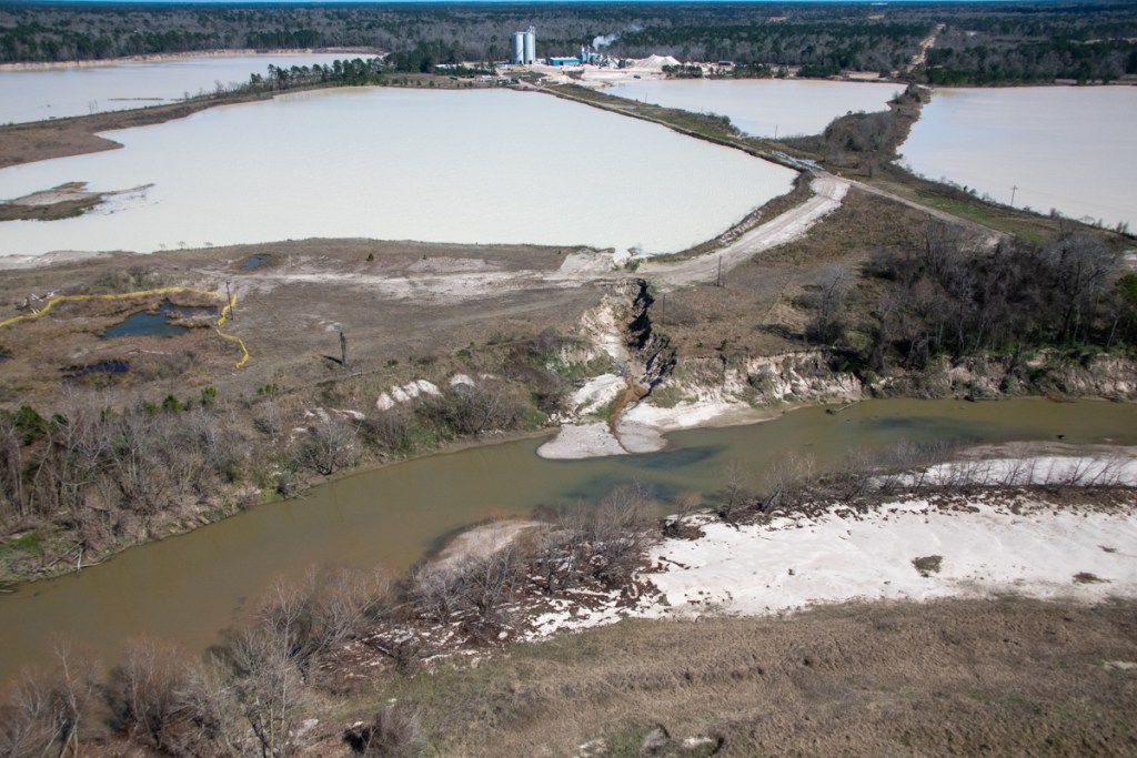
West Fork Images from February Flyover
Below, a sampling of more than 1000 images I took on 2/13/2020. The first batch shows mines on the San Jacinto West Fork between SH242 and US59. I traveled NW to SE toward 59. I’ve arranged images in the same order.
Sand mine pond and water’s path to the river (right).Pond is full to the brim and will overflow on a minor rain.
Another angle looking north toward the same breach.
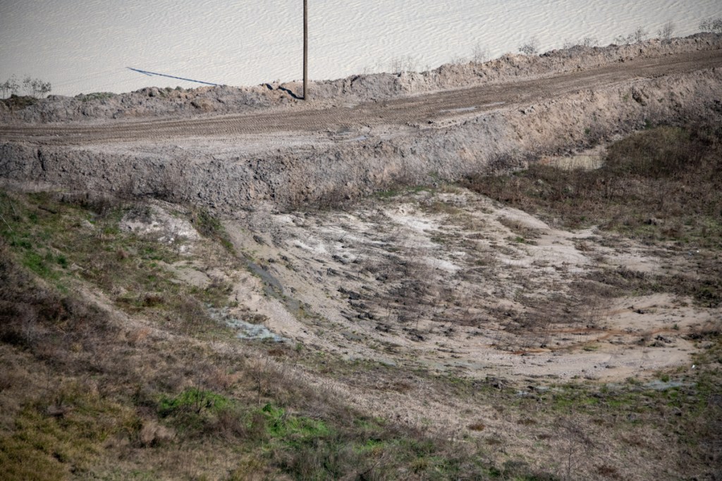
West Fork is migrating toward pit on right and will soon enter it. A powerful argument for reasonable setbacks from river.
Another pond at the same mine. The only thing holding back another illegal discharge is a feeble road made of sand. See close up in next pic of area near poll just left of center.
Close up of road in upper left of previous photo. Note how water seeping through it is already causing road to collapse.
Silt spreading into settling pond. See also reverse shot below.
Reverse angle from previous shot, but same pond. See West Fork in background and note how road in foreground was cut by spreading silt.
Site of previous double breach at RGI mine. Note gray area in second row of dikes. Process water from the pond behind it broke into the settling pond in the foreground and from there into the West Fork. TCEQ cited owners.
Two separate ponds may have shared this same “wash” to the river (foreground). Pond in middle right is actively discharging into river. See reverse angle in next shot.
Same discharge as in previous shot. From this angle it is easier to see the active discharge.
Same breach from third angle. From this angle, you can clearly see the path and the discharge.
This pond has been discharging into the river for months. Note the difference in the color of the river water and discharge water. This indicates the discharge water is still holding silt.
Reverse shot of same breach highlights both the path and the color difference of the discharge.
This pond is leaking into a drainage channel that parallels Northpark Drive south of Oakhurst.
Former breach at Eagle mine on Sorters Road. West Fork in foreground.
Scars from previous breaches. One of these was intentional, though I’m not sure which. See video below.
Video by resident who wishes to remain anonymous shows intentional breach at the mine above.
Another scar from previous breach.
Confluence of Spring Creek (left) and West Fork San Jacinto (right).Facing west.Note color difference in water. It’s frequently visible.
Same area looking southeast toward Humble.West Fork on left.
Same area looking NE toward Kingwood.West Fork comes in from left.Between the 59 bridge in the previous shot and this area, the Army Corps spent more than $90 million removing sediment from the West Fork. The City, County and State could spend another $35 million removing this blockage.
Wider shot shows just how much forest was blown out in this breach, leading one to wonder whether this was caused solely by nature.Another former breach into Caney Creek from the Triple PG mine. Only this eroding road stands between the mine and the creek.
Also at the Triple PG mine in Porter, this breach into White Oak Creek remained open for months. It, too, was the subject the Attorney General’s lawsuit. A restraining order against the mine calls for repairs to be certified by a professional engineer. This looks as though they may have tried to add concrete to the sand and stabilize it with rebar. However, note that the concrete, if that’s what it is, doesn’t rise much above the water. The road is made from eroding sand that will blow out in the next storm.
Reverse shot of same breach looking west. No concrete or rebar visible here – only rilling along steep sides of road. Rilling is the term for those vertical erosion channels.
Posted by Bob Rehak on 2/24/2020
909 Days since Hurricane Harvey and 158 since Imelda
The thoughts expressed in this post represent opinions on matters of public concern and safety. They are protected by the First Amendment of the US Constitution and the Anti-SLAPP Statute of the Great State of Texas.
https://i0.wp.com/reduceflooding.com/wp-content/uploads/2020/02/20200213-RJR_7753.jpg?fit=1200%2C800&ssl=18001200adminadmin2020-02-24 15:22:182020-02-24 15:29:12Are Sand Mine Dikes Designed to Fail?
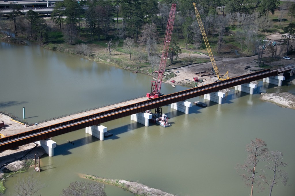
Replacement of the old Union Pacific Bridge across the San Jacinto West Fork is nearing completion.
Less than a month ago, crews constructing the new railroad bridge still had to remove the supports for the old bridge. See below the old four-post steel-frame structures between the new cement supports.
Photo taken on January 20, 2020 shows old supports still in place between new concrete supports.
By 2/13/2020, however, only one of the old supports remained. See photo below.
Photo taken on 2/13/2020 shows only one of the old supports remains.
Trees caught in Union Pacific Railroad Bridge supports during Hurricane Harvey.
The result: the tracks were destroyed. UP had to reroute northbound rail traffic out of Houston for months as they literally built a new bridge around the old one.
Harvey knocked out the Union Pacific Railroad bridge over the San Jacinto River near I-69.
The concrete supports for the new bridge are spaced much farther apart. Thus, they should allow trees to pass through in a flood and eliminate backwater effects.
Photo taken 2/13/2020, the same time as the first shot above. This is from the other side of the bridge.
Other Sign Job is Nearing Completion
Notice in the picture above that crews have already started removing the temporary bridge for cranes on the north side of the river.
All of this is good news from flood remediation and mitigation perspectives. It is yet one more sign that life is finally starting to return to normal after Harvey. The bridge should also help the community deal better with the next major storm.
Posted by Bob Rehak on 2/17/2020
902 Days since Hurricane Harvey
https://i0.wp.com/reduceflooding.com/wp-content/uploads/2020/02/20200213-RJR_7956.jpg?fit=1200%2C800&ssl=18001200adminadmin2020-02-16 19:46:332020-02-16 19:46:51Union Pacific Almost Done Removing Last Remnants of Old Railroad Bridge