Why Harris County Had 31 100-Year Floods in 100 Years
2/7/26 – According to Harris County Meteorologist Jeff Lindner, the county has had at least 31 100-year floods in the previous 100 years. That’s between 1925 and 2025. “How can that be?” you ask. “Doesn’t a 100-year flood only happen once in a 100-years?”
Short answer, NO. To increase your safety and protect your home, read on.
Main Reasons for Apparent Contradiction
Numerous reasons exist for the apparent contradiction in the headline. They fall into three broad categories.
- Widespread misunderstanding of the definition of a “100-year flood”: the term means different things to hydrologists and to the public.
- Physical changes to floodplains and channels since the last flood-map update: Upstream development, sedimentation, lack of maintenance, etc. can all increase your flood risk.
- Evolving statistical estimates of floodplains: Reliable weather records only go back about 130 years in this region. Predicting future risk using such a small statistical base has inherent risks of its own.
Widespread Misunderstanding of Definition
Let’s address misunderstanding of the definition first. The term “100-year flood” emerged in the early part of the 1900s to describe a flood that has a 1% chance of happening each year at any given geographic point.
So, technically, 100-year floods could occur in back-to-back-to-back years. And they have. See Lindner’s list of Harris County’s 31 “100-year floods” below.
- 5/31/29: Buffalo Bayou
- 12/9/35: Buffalo Bayou
- 10/9/49: Cypress Creek
- 9/11/61: Sims Bayou
- 6/20/73: Sims Bayou
- 6/11/75: Sims Bayou
- 7/25/79: Clear Creek, Armand Bayou, Sims Bayou, Vince Bayou
- 9/20/79: Clear Creek, Sims Bayou
- 5/3/81: Vince Bayou
- 8/18/83: Sims Bayou, Vince Bayou, Halls Bayou
- 9/19/83: Sims Bayou
- 6/26/89: Greens Bayou
- 8/1/89: Sims Bayou
- 10/18/94: Clear Creek, Sims Bayou, San Jacinto River, Spring Creek, Little Cypress Creek, Cedar Bayou
- 10/18/98: South Mayde Creek, Bear Creek, Spring Creek, Little Cypress Creek
- 11/14/98: Little Cypress Creek, Spring Creek
- 6/5/01: Clear Creek, Vince Bayou
- 6/9/01: Clear Creek, Armand Bayou, Brays Bayou, White Oak Bayou, Hunting Bayou, Vince Bayou, Little Cypress Creek, Willow Creek, Carpenters Bayou, Greens Bayou, Halls Bayou, Buffalo Bayou
- 10/29/02: White Oak Bayou
- 8/16/07: Vince Bayou
- 9/13/08: Vince Bayou, Bear Creek, South Mayde Creek
- 4/28/09: Bear Creek, South Mayde Creek, Buffalo Bayou
- 7/12/12: Little Cypress Creek
- 5/13/15: Armand Bayou
- 5/26/15: Keegans Bayou, White Oak Bayou, Buffalo Bayou
- 10/31/15: Cedar Bayou
- 4/18/16: Keegans Bayou, Spring Creek, Little Cypress Creek, South Mayde Creek, Bear Creek, Horsepen Creek
- 5/27/16: Spring Creek, Little Cypress Creek
- 8/27/17: Nearly every watershed
- 9/19/19: San Jacinto River, Cedar Bayou
- 5/2/24: San Jacinto River
Many of these watersheds have seen 5 to 10 extreme floods in the last 100-years.
“100-Year Flood” is an estimate of probability and not a guarantee of frequency.
Keep that in mind if you’re shopping for a new home or considering cancelling your flood insurance.
Physical Changes to Floodplains/Channels
The other thing to keep in mind is that floodplains constantly change. You could be high above them one year and far below the next because of changes to the terrain upstream.
I once owned a home in Dallas that went from 2 feet above a 100-year floodplain to 10 feet below it in less than three years. How? One insufficiently mitigated, new development upstream. Think it can’t happen here? Look at Colony Ridge in the East Fork Watershed. It didn’t exist 15 years ago and is now 50% larger than Manhattan.
When buying a home, consider such factors as:
- Subsidence from excessive groundwater withdrawals in Montgomery County (MoCo) could reduce a home’s elevation relative to the Lake Houston Dam. That would reduce the safety margin between your slab and floodwaters.
- Sedimentation could reduce the conveyance of a channel or massively block it. During Harvey, sand washing downstream reduced conveyance of the West Fork by 90%, according to the Army Corps.
- Much of that sand came from sand mines in MoCo. Mines have deforested 20 square miles in a 20-mile length of the river between I-45 and I-69. That exposes a swath of sediment averaging a mile wide to floodwaters.
- MoCo actually gives tax breaks to those mines that encourage deforestation, rapid sedimentation and downstream flooding.
- Until recently, the state didn’t require minimum setbacks from the river for mines. Because of erosion, the river now runs through mines in at least six places on the West Fork.
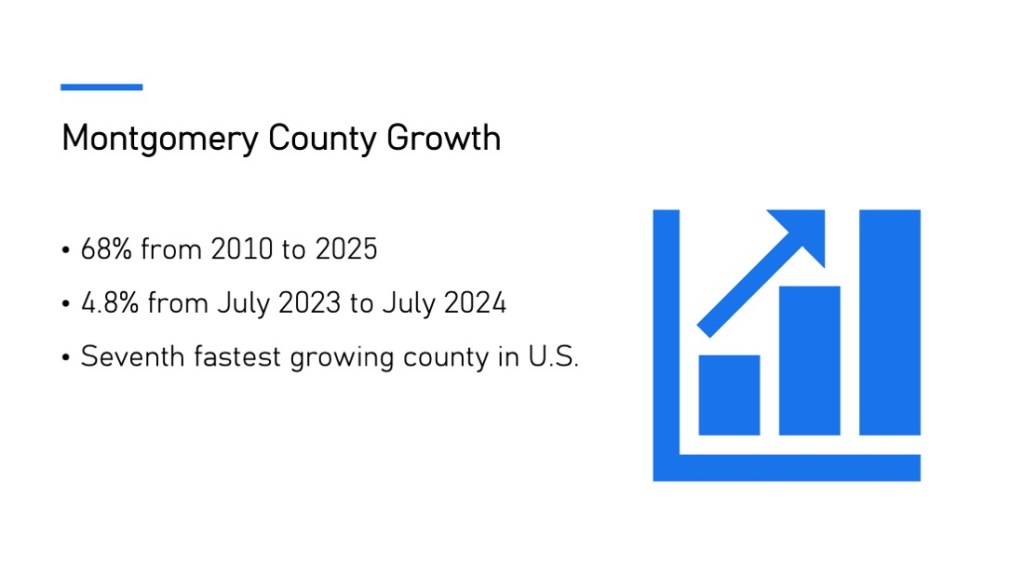
- MoCo is one of the ten fastest growing counties in America. Roads, driveways and rooftops increase the volume and speed of runoff, causing floodwater to peak higher and faster downstream.
- Complicating that, MoCo has not enforced its own floodplain regulations. I have published dozens of stories about that, including the blatant transgressions that flooded 600 homes in 2019 along Taylor Gully across the county line from Perry Homes’ Woodridge Village development.
- When most of the region adopted new drainage and floodplain regulations shortly after Harvey in 2017, MoCo took until late 2025. And their new regs didn’t meet the minimum standards adopted elsewhere.
- One MoCo legislator fought for the right to develop new subdivisions in floodplains, even as another voted against establishing a Dredging and Maintenance District for the Lake Houston Area.
Evolving Statistical Estimates/Building Codes
Climate change aside, such factors as those above make estimating flood risk a shifting target. Worse, the small statistical base for those estimates gives them a large margin of error.
Complete rainfall records for Harris and Montgomery Counties only go back to the early 1890s. So, we’re trying to estimate 100-year rainfalls by looking at one complete 100-year cycle out of 4.56 billion years. That’s as difficult as predicting a statewide election outcome by interviewing one person!
As a result, scientists update rainfall estimates after most major storms such as Harvey and Allison. But that can take years. FEMA is just now releasing new flood maps based on high-water marks and elevation data acquired after Harvey. And MoCo’s population has grown by about a third since then – enough to skew results significantly.
As upstream counties pursue growth, downstream counties must require higher elevations in building codes. But that won’t help already-built homes in older neighborhoods. To help those residents, we must pursue expensive flood mitigation to offset the increased flood peaks resulting from upstream growth.
There’s just no option; it will never end. We can never give up trying to offset competing interests. Or we’re sunk.
Posted by Bob Rehak on 2/7/2026
3084 Days since Harvey
The thoughts expressed in this post represent opinions on matters of public concern and safety. They are protected by the First Amendment of the US Constitution and the Anti-SLAPP Statute of the Great State of Texas.