Tag Archive for: Texas Attorney General

Triple P.G. Owner Transferred Ownership of Sand Mine Days After AG Filed Suit

Mere days after the Texas Attorney General (AG) filed a lawsuit against Triple P.G. Sand Development, the mine’s owner transferred ownership of the mine. Even though the transfer was recorded in October, the attorney general says the papers were dated for the prior January — before the unauthorized discharges from the mine that triggered the AG’s lawsuit.

Hundreds of Millions of Gallons of Wastewater Discharged

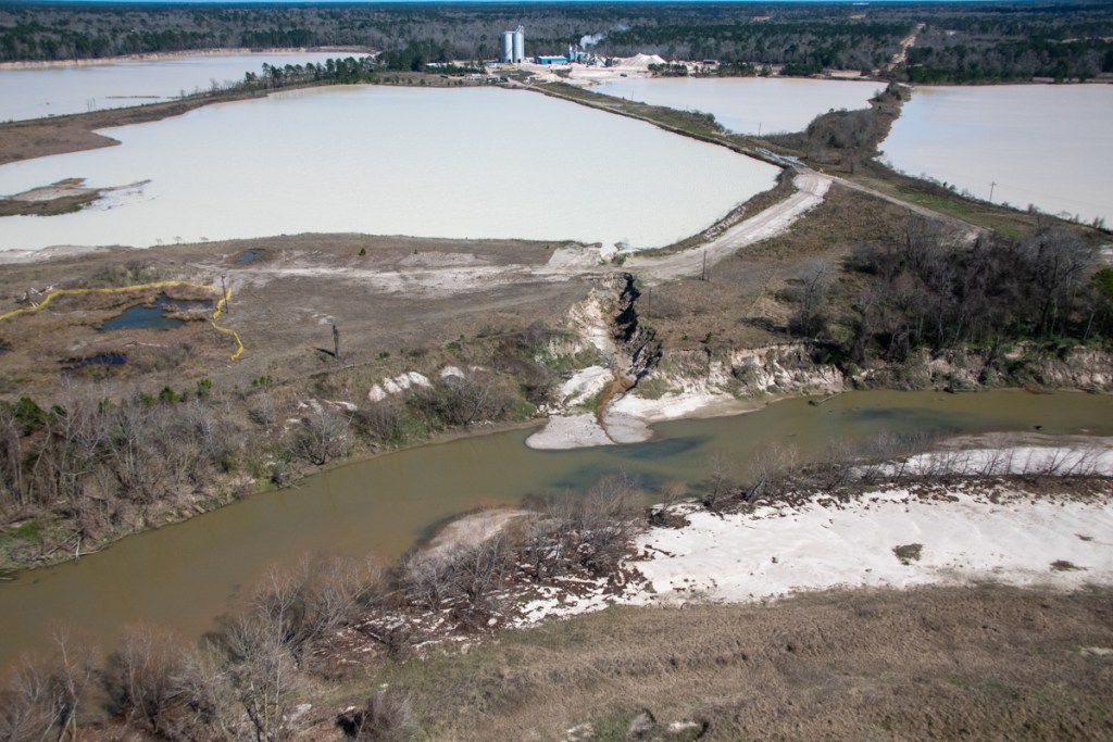
Two unauthorized discharges from the mine in Porter during May and September last year let hundreds of millions of gallons of sediment-laden wastewater escape into the headwaters of Lake Houston, the source of drinking water for 2 million people.

The putative ownership transfer was recorded in October, days after the lawsuit was filed. But it was dated for the prior January—before the May and September discharges that triggered the law suit!

Triple P.G. Mine in Porter. Photographed on 6/16/2020. Bright colors likely due to high chloride content or Cyanobacteria which may contain cyanotoxins.

Suspicious Ownership Transfer

The AG didn’t allege any motives. But the suspicious ownership transfer may have been an attempt to shield assets from prosecutors. People often set up multiple companies, trusts and partnerships to shield assets in one from lawsuits in another.

As a result of the transfer, the Texas Attorney General (AG) amended the State’s original petition and application for injunctive relief against Triple P.G. on 6/17/2020. The new petition added five additional defendants. They include:

  • Guniganti Family Property Holdings, L.L.C.
  • Prabhakar R. Guniganti, individually
  • Prabhakar R. Guniganti, as Director of Triple P.G. Sand Development, L.L.C.
  • Prabhakar R. Guniganti, as sole manager of Guniganti Family Property Holdings, L.L.C.
  • Guniganti Children’s 1999 Trust.

TCEQ Surprised by “Different Operator” at Facility

The Attorney General’s amended petition states, “In or around May 2020, prior to expiration of the Temporary Injunction, Texas Commission on Environmental Quality (TCEQ) investigators conducted a site visit and were informed that a different operator had taken over operations at the Facility.”

Ironically, instead of shielding assets (if that’s what he was trying to do), Guniganti exposed more of his family’s holdings. Now they’re all part of the lawsuit.

Guniganti Family Property Holdings, L.L.C. was the recorded property owner at the time of the May and September 2019 breaches. However, new ownership records now show that in October 2019, Guniganti Children’s 1999 Trust owned the property.

Prabhakar R. Guniganti is the sole director of Triple P.G. Sand Development and sole manager of the Guniganti Family Property Holdings. The AG’s amended petition alleges Guniganti orchestrated the ownership transfer as the sole manager of Defendant Guniganti Family Property Holdings.

Officially, the State filed the amended petition to name additional entities that are responsible for the 2019 discharges. They also share a continuing responsibility to prevent discharges in the future by performing corrective actions to improve the site.

Basis for Lawsuit

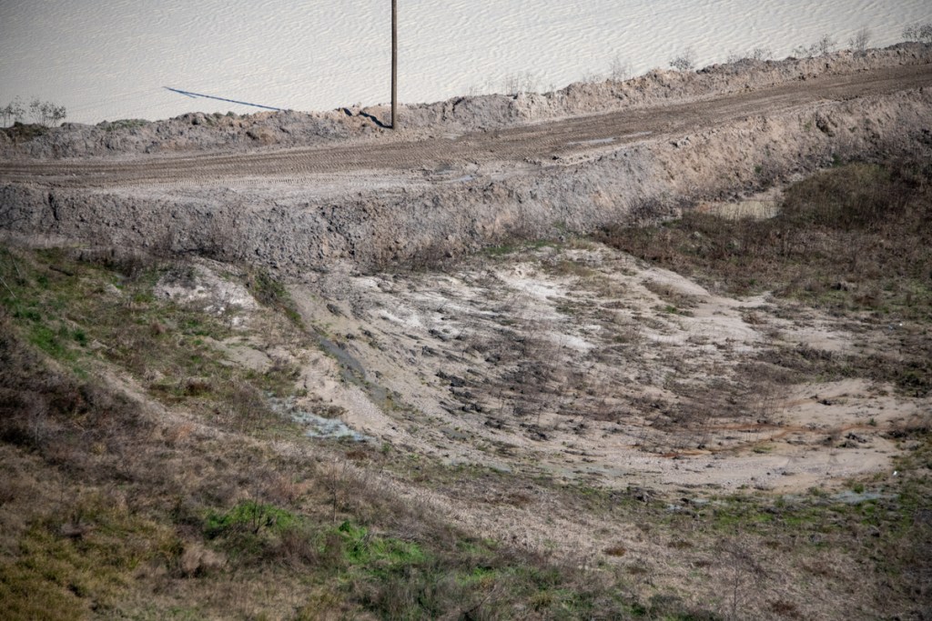
The TCEQ cited Triple P.G. in both months during 2019 for the unauthorized discharge of millions of gallons of sediment-laden process wastewater. In May, the entire contents of the Triple P.G. dredge pond (about 180 acres in area) were released into Caney Creek. TCEQ estimates 325 million gallons of sediment-laden water exited into Caney Creek, which leads directly to the East Fork of the San Jacinto River and onward to Lake Houston. Then, more breaches occurred in September, 2019.

Triple P.G. agreed to injunctive relief last fall. The injunction required Triple P.G. to cease dredging operations, to repair breaches, and to retain an engineer who would propose a plan to ensure the berms could hydraulically isolate the process waste water from waters of the State. The Court entered the Agreed Temporary Injunction on November 25, 2019.

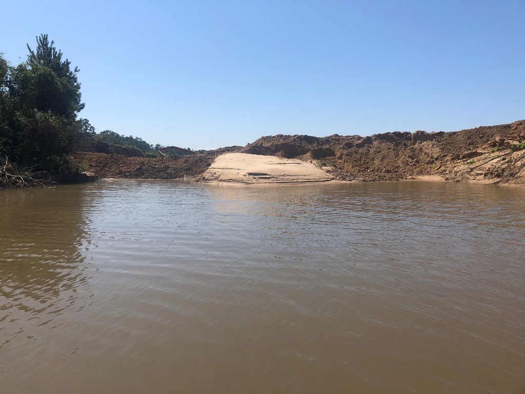
Ever since, Guniganti has been trying to dry-mine sand. Miraculously, water inside the mine has disappeared while water outside the mine has gotten higher.

The AG contends that regardless of which entity owned the mine, they all lead back to the same man and they all had an obligation to ensure that process wastewater was not discharged into waters of the State.

The AG believes all entities are liable for unauthorized discharges pursuant to Texas Water Code 26.121(c), which makes it unlawful to “cause, suffer, allow, or permit the discharge of any waste” in violation of the Texas Water Code.

Dr. Guniganti At Center Allegations

“As the individual with complete management control of sand mining company Triple P.G. and with complete management control of the property on which the Facility is located, Defendant Guniganti had authority to direct activities at the site, including the authority to prohibit or modify sand mining operations on the property, to ensure Triple P.G. maintained adequate berms, and/or to maintain the berms at the Facility to ensure that process wastewater was not discharged into waters of the state,” the AG alleges.

Guniganti, a cardiologist from Nacogdoches who moonlights as a miner, could be fined up to a million dollars for the discharges.

These discharges are the latest in a long series of problems for the troubled mine. For the complete list, read the Attorney General’s entire 51-page amended petition.

The defendant(s) have until July 20, 2020, to respond to the amended petition.

In other developments in the case, Dr. Guniganti has requested to replace his Austin-based attorney with one from Lufkin.

Posted by Bob Rehak on July 1, 2020

1037 Days after Hurricane Harvey

The thoughts expressed in this post represent opinions on matters of public concern and safety. They are protected by the First Amendment of the US Constitution and the Anti-SLAPP Statute of the Great State of Texas.

Are Sand Mine Dikes Designed to Fail?

After 2.5 years of examining photos and videos of the so-called “dikes” in sand mines, I have come to believe that some are designed to fail. In some cases, mines cause them to fail.

In most cases, the “dikes” are not really dikes. They’re just the edges of pits that miners have excavated. Or roads around the pits made of sand that easily erode.

And because miners mine so close to the river, when those pits fill with water, they overflow. The resulting erosion cuts channels between the pit and the river that allow the pits to discharge a portion of their wastewater. Lake Houston and public drinking water become collateral damage.

High Cost of Flimsy Construction

After the storm, miners throw some sand in the breach and wait for it to happen again. The sand creates only the appearance of a fix.

Month after month, I’ve photographed active breaches, “patched” breaches, and scars in the landscape from older breaches. Many reopen multiple times.

Breaches are so common that, in my opinion, they may be part of some miners’ business plans.

High Cost of Silt

If discharges consisted of plain water, I might not care. But the water usually carries silt with it. Miner’s settling ponds can fill with silt which has little marketable value. Flushing it downriver solves another problem.

Miners externalize their cleanup costs by foisting them off on an unsuspecting public. That sediment clogs rivers that must be dredged to avoid flooding. It reduces the capacity of the lake. And it escalates the City’s water treatment costs.

A retired high-level Public Works manager told me he routinely investigated and found breaches at sand mines during floods. In his opinion, many of the breaches were intentional and the floods created the perfect “cover” for the illegal discharges. “Blame it on Mother Nature,” he said.

West Fork Images from February Flyover

Below, a sampling of more than 1000 images I took on 2/13/2020. The first batch shows mines on the San Jacinto West Fork between SH242 and US59. I traveled NW to SE toward 59. I’ve arranged images in the same order.

Sand mine pond and water’s path to the river (right). Pond is full to the brim and will overflow on a minor rain.
Another angle looking north toward the same breach.
West Fork is migrating toward pit on right and will soon enter it. A powerful argument for reasonable setbacks from river.
Dike erosion at Liberty Materials Mine. The TCEQ alleges this mine discharged 56 million gallons of that white gunk into the West Fork last November. This breach has been like this for months.
Another pond at the same mine. The only thing holding back another illegal discharge is a feeble road made of sand. See close up in next pic of area near poll just left of center.
Close up of road in upper left of previous photo. Note how water seeping through it is already causing road to collapse.
Silt spreading into settling pond. See also reverse shot below.
Reverse angle from previous shot, but same pond. See West Fork in background and note how road in foreground was cut by spreading silt.
Site of previous double breach at RGI mine. Note gray area in second row of dikes. Process water from the pond behind it broke into the settling pond in the foreground and from there into the West Fork. TCEQ cited owners.
Two separate ponds may have shared this same “wash” to the river (foreground). Pond in middle right is actively discharging into river. See reverse angle in next shot.
Same discharge as in previous shot. From this angle it is easier to see the active discharge.
Same breach from third angle. From this angle, you can clearly see the path and the discharge.
This pond has been discharging into the river for months. Note the difference in the color of the river water and discharge water. This indicates the discharge water is still holding silt.
Reverse shot of same breach highlights both the path and the color difference of the discharge.
This pond is leaking into a drainage channel that parallels Northpark Drive south of Oakhurst.
Former breach at Eagle mine on Sorters Road. West Fork in foreground.
Scars from previous breaches. One of these was intentional, though I’m not sure which. See video below.
Video by resident who wishes to remain anonymous shows intentional breach at the mine above.
Another scar from previous breach.
Confluence of Spring Creek (left) and West Fork San Jacinto (right). Facing west. Note color difference in water. It’s frequently visible.
Same area looking southeast toward Humble. West Fork on left.
Same area looking NE toward Kingwood. West Fork comes in from left.
Between the 59 bridge in the previous shot and this area, the Army Corps spent more than $90 million removing sediment from the West Fork. The City, County and State could spend another $35 million removing this blockage.

East Fork Images from February Flyover

Breach into Caney Creek at Triple PG sand mine was open for months and became the focus of a suit by the Attorney General. Note steepness of sides of “fix,” and erosion along side. Best Management Practices call for sloping and planting sides of dikes to reduce erosion.
Wider shot shows just how much forest was blown out in this breach, leading one to wonder whether this was caused solely by nature.
Another former breach into Caney Creek from the Triple PG mine. Only this eroding road stands between the mine and the creek.
Also at the Triple PG mine in Porter, this breach into White Oak Creek remained open for months. It, too, was the subject the Attorney General’s lawsuit. A restraining order against the mine calls for repairs to be certified by a professional engineer. This looks as though they may have tried to add concrete to the sand and stabilize it with rebar. However, note that the concrete, if that’s what it is, doesn’t rise much above the water. The road is made from eroding sand that will blow out in the next storm.
Reverse shot of same breach looking west. No concrete or rebar visible here – only rilling along steep sides of road. Rilling is the term for those vertical erosion channels.

Posted by Bob Rehak on 2/24/2020

909 Days since Hurricane Harvey and 158 since Imelda

The thoughts expressed in this post represent opinions on matters of public concern and safety. They are protected by the First Amendment of the US Constitution and the Anti-SLAPP Statute of the Great State of Texas.

Triple PG Mine Scurries to Fill Breaches Day After Attorney General Files Lawsuit

Twenty-three days after Imelda and one day after the Texas Attorney General filed a lawsuit seeking injunctive relief, the owners of the Triple PG Mine in Porter finally took some action to seal at least one of the eight breaches in their dikes.

Photos Taken Saturday Show Start of Repairs

Josh Alberson took the photos below from Caney Creek around 11:30 a.m. on Saturday, October 12, 2019.

While there is now dirt in the breach, it’s not certain what kind. According to Alberson, it appears to be a mix of clay and sand.
If this is the same material used in the same way to plug the May breach, it will probably fail the same way in the next flood.

No Serious Attempt to Compact Materials

Alberson says he observed mine employees dumping fill in the breach, but that he saw no attempt to compact the material with rollers. They did tamp it down with the bucket of the track hoe, however. Here’s what it looked like at about 2PM Saturday from Caney Creek. Not very tamped.

Water in the foreground is part of the original May breach. Repairs from May and so far from September, focused on building a road over the breach that acts as a dam. Two hundred feet of woods once separated the mine from the pit. This “dam” or “dike” is now about 15 feet wide and barely above the water at the low point.

Compare Width of Road to Length of Total Breach

The photo below shows the breach in question before repairs. I shot it from a helicopter on 10.2.2019.

Photo of breach looking west into pit before repairs. Note the location of the island and the width of the road relative to the length of the breach between the pit and Caney Creek (bottom left). Then review the satellite image below from Google Earth taken in February.
Google Earth satellite image before breach in May. Yellow line represents approximate location of breach and measures 218 feet from pit to Caney Creek. Approximate width of repair is 15 feet, 1/14th the width of the original barrier.
Here you can see the width of the road at the end of work today (10/12/2019). Enough to accommodate one way traffic. A reader sent it to me.

Civil Engineer’s Impression of Repairs

Alberson’s brother is a civil engineer. He and another engineer I talked to both felt the repairs were inadequate. When asked what the repairs should consist of, Alberson’s brother suggested:

  • Temporary dam cut at river and in pit.
  • Pump out water.
  • Bring in 100% clay and fill entire dike and previous bank with clay in 1 ft. increments. 
  • Measure clay at its mining point for water content.
  • After each foot, add spray water, then allow to dry to achieve optimum clay cohesion.
  • Roll pack with smooth drum roller.
  • Repeat to needed height.
  • Add geotextile, large stone, and smaller gravel followed by grass on river and pit side.
  • Width and height of damn should be determined by vertical drop of pit and horizontal width (i.e., water pressure on dike). 

He said if they don’t “roll-pack” it, regardless of whether it is made of clay or not, it will fail.

Request for Required Engineering Docs

I requested the TCEQ to provide the engineering documents for the repairs that they demand, consistent with section 301 of their regulations for dikes and levees. Because of the weekend, they could not supply them immediately, but agreed to look and see if they existed.

Impact of “Dike” Failures on Families South of Mine

In the meantime, I interviewed three families below the mine today. They and physical evidence all indicated that water swept through the mine from north to south during Imelda. They said the MINE then flooded them before White Oak or Caney Creek rose. The water from the mine rose so quickly that:

  • One family narrowly escaped with their horses (unlike Harvey when one died).
  • Water covered a second family’s SUV in less than one hour. Their house – on 10-foot silts – took on two feet of water.
  • A third family fled early with their disabled daughter, only to find their home destroyed again when they returned. They also found their foundation undermined by the force of the water from the mine.

There really are no dikes between the mine and these families and dozens of others in their neighborhood. The road surrounding the mine is flush with ground level. It provides no protection when stormwaters capture the pit.

More on their stories in future posts. In the meantime, here are some photos of the heartbreaking devastation they suffered.

The back of Tom and Sherry Gills garage faces the mine. Just feet from the mine’s southern boundary, scouring was so bad that it undermined the foundation.
Shelley Portillo’s porch also faces the mine. Water went in one side of her home and exited the opposite side, leaving sand waves in her home.
Melissa Stowe’s back yard. Direction of flow came from mine and pushed construction debris up against tree line. Elevating her house ten feet after Harvey wasn’t enough. Twelve feet of water inundated her property.

Posted by Bob Rehak on 10/12/2019 with help from Josh Alberson and Charlie Fahrmeier

774 Days since Hurricane Harvey and 23 since Imelda

The thoughts expressed in this post represent my opinions on matters of public interest and safety. They are protected by the First Amendment of the US Constitution and the Anti-SLAPP Statute of the State of Texas.

Texas Attorney General Files Charges Against Triple PG Sand Mine

The Texas Commission on Environmental Quality (TCEQ) announced today that the Texas Attorney General has filed a petition and application for injunctive relief against the Triple PG Sand Development, L.L.C. of Kingwood. The charges allege violations of Chapter 26 of the Texas Water Code and related TCEQ rules pertaining to the discharge of industrial waste and process wastewater.

For the full text of the attorney general’s filing which includes TCEQ investigations dating back to 2015, click here.

Note that the latest TCEQ investigation only covers breaches that investigators could reach safely from the ground. However, from the air, I observed many more breaches.

Maximum Possible Penalties

If past performance is any indication of the future, the mine is likely to receive a slap on the wrist. Fines against sand mines from the TCEQ have averaged around $800. However, this is more serious. The attorney general is involved. And stiffer penalties are now available thanks to a new law sponsored by State Representative Dan Huberty in the last legislation session.

If a court levies maximum penalties against this mine, the owners could be liable for $1.1 million plus $25,000 per day for each day breaches in the mine’s dikes remain open. That could easily exceed another half million dollars.

In addition, Ramiro Garcia, head of enforcement for the TCEQ, said the commission disengaged from settlement talks with Triple PG regarding May breaches. Those breaches also took weeks to patch. If lumped in with this, the court could assess yet another half million dollars.

Claim Patches in May Breaches Made with Clay

According to the results of the May investigation, investigators believe the mine patched its breaches with clay. But photos of the failed dikes indicate they were made from sand.

Breach of Triple PG Mine on Caney Creek in September. Photo taken 9/29/19.
Close up of same breach reveals that this repair was clearly made from sand. Photo taken on 9/29/2019.
Here’s what the same breach looked like from the air. Photo taken on 10/2/2019. I photographed at least 7 additional breaches that same day.
Photo courtesy of Josh Alberson, showing that the breach remained open last Saturday, October 5, when he took this shot from his jet boat on Caney Creek. Investigators found the same breach open on the 9th, 20 days after Imelda.

About Chapter 26 of Water Code

Chapter 26 covers water quality control and industrial waste water. It defines “Industrial waste” to mean “…waterborne liquid, gaseous, or solid substances that result from any process of industry, manufacturing, trade, or business.” Its definition of “pollutant” includes “dredged spoils.”

“Pollution” also means “the alteration of the physical, thermal, chemical, or biological quality of, or the contamination of, any water in the state that renders the water harmful, detrimental, or injurious to humans, animal life, vegetation, or property or to public health, safety, or welfare, or impairs the usefulness or the public enjoyment of the water for any lawful or reasonable purpose.”

Triple PG Mine is at the confluence of floodways for White Oak Creek and Caney Creek.

The mine is in the confluence of two floodways: White Oak Creek and Caney Creek. Both are tributaries to Lake Houston, the source of drinking water for millions of people. The purpose of Chapter 26: “to maintain the quality of water in the state consistent with the public health and enjoyment…”

The code considers the possible adverse effect that illegal discharges might have on receiving bodies of water, such as Lake Houston, and on parks, such as East End Park in Kingwood.

Although the Code permits some discharges. However, “Discharges covered by the general permit will not include a discharge of pollutants that will cause significant adverse effects to water quality.”

Chapter 26 stretches more than 200 pages and 58,000 words. So I won’t attempt to summarize it here, except to say that it also includes the disposal of chlorides. One former executive for the City of Houston’s public works department told me that he personally witnessed many sand mines intentionally breaching dikes under the cover of floods to eliminate chloride buildups in their wash water.

About TCEQ Rules Pertaining to Industrial Waste

It is not immediately clear which TCEQ rules pertaining to the discharge of industrial waste and process wastewater are part of the charges. The TCEQ also enforces water quality rules for rivers and lakes.

“Companies that pollute Texas waterways will be held accountable,” says TCEQ Executive Director Toby Baker. “Every business has a responsibility to respect laws that protect the environment and public health, and I applaud the attorney general for acting swiftly on my request to hold Triple P.G. Sand Development fully responsible.”

The State of Texas requests that the court grant the following relief as allowed by law:

  • A permanent injunction
  • Civil penalties and reasonable attorney fees
  • Court costs
  • Investigative costs.

Repeated Dike Failures

The dikes of the Triple PG Sand Mine do not appear to comply with TCEQ rules for dike construction. They are built from sand and have failed repeatedly in multiple locations. However, the TCEQ rules clearly state, that structural integrity is the number one concern. “Construction must be based upon sound engineering principles. Structural integrity must withstand any waters which the levee or other improvement is intended to restrain or carry, considering all topographic features, including existing levees.”

The Attorney General’s charges do not mention dike construction. Reading the requirements, however, it will be interesting to see which professional engineer signed off on the plans. The requirements state:

§301.36. Plans To Bear Seal of Engineer.

“All preliminary plans and other plans which are submitted with an application for approval of a levee or other improvement shall be prepared by or under the direction of a registered professional engineer and signed by the registered professional engineer whose seal shall appear upon or be affixed thereto.”

Stay tuned. More investigation to follow.

Posted by Bob Rehak on 10/11/2019, with thanks to Dan Huberty, Charlie Fahrmeier and Josh Alberson

773 Days after Hurricane Harvey and 22 after Imelda

All thoughts in this post represent my opinions on matters of public safety and policy. They are protected by the First Amendment of the US Constitution and the Anti-SLAPP Statute of the Great State of Texas.