3/20/26 – This week, we had more two more examples of flood-mitigation projects that are being studied to death.
Spring Creek Watershed Flood Control Dams on Birch and Walnut Creeks
Kingwood Diversion Ditch
They might not be buried yet, but they might as well be.
Let’s look at each and the implications for flood control.
Birch and Walnut Creeks
The two flood-control projects in the Spring Creek watershed were first studied in 1976 (see page 24) when the land was predominantly forested and could have been purchased for a tiny fraction of what it costs today. No one took action then. The benefit/cost ratio came in close to zero; project costs far outweighed benefits by more than 10:1.
This week, 50 years later, SJRA published another study, suggested by a previous 2020 study. And the new study suggested yet another study. But the study just published took so long – 5 years – that land for the projects sold to developers before SJRA completed the study. Whew! Follow all that?
So, the current study’s authors actually suggested yet another study to see if an unidentified sponsor could buy the property (which isn’t for sale) – while engineers design the dams, which probably won’t qualify for funding.
Why? The current study took so long that the federal government excluded social benefits from Benefit/Cost Ratios (BCRs). But the reported BCRs included social benefits…because the study’s authors hoped the Federal Government might include them again at some point in the future. So much for making studies actionable!
It may be time to put this one out of its misery. SJRA can’t even seem to interest Waller County in helping, even though its own residents would benefit the most.
Sites of proposed flood-control dams in NE Waller County within the Spring Creek Watershed.
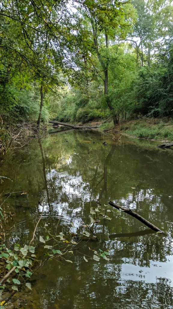
Kingwood Diversion Ditch
One third of all the people who died in Harris County during Harvey died along Bens Branch when the Kingwood Diversion Ditch couldn’t divert enough stormwater.
Ben’s Branch and the Kingwood Diversion Ditch operate as one system to drain the western half of Kingwood. Friendswood conceived the Diversion Ditch as a way to take pressure off Ben’s Branch. But over time, upstream development has overwhelmed both.
Back in 2020, HCFCD’s Kingwood Area Drainage Analysis named the Diversion Ditch the most important project in the area. Congressman Dan Crenshaw requested a $1.6 million grant for Diversion Ditch design in 2021 and obtained it.
Then a preliminary engineering review took three years longer than planned and was widely criticized for missing opportunities.
Next, HCFCD took two years to negotiate the price of the design phase which should have finished by now. But it hasn’t even started yet. So yesterday, HCFCD requested a 2-year extension on the grant.
If lucky, we may see the design by 2028 – 11 years after Harvey. Then come the long and arduous tasks of obtaining funding and completing construction. By then, new upstream development will likely have changed design assumptions. And another study may be necessary.
To widen a straight-line ditch, we’ve already spent twice as much time as it took the U.S. to win World War II.
Looking South along the Kingwood Diversion Ditch from Kings Mill
Political Fragmentation Favors Delay, Not Decisiveness
In my opinion, both of these flood-mitigation projects have stalled because the people in charge of them have lost all sense of urgency or can’t see a clear path to completion.
Action is difficult in the highly fragmented world of flood control because it requires coordination among multiple government agencies on the local, county, state and federal levels. It’s much easier to create the appearance of action – with studies.
But the studies by themselves do nothing to reduce flood risk. For those with long memories or PTSD, they at least hold out hope that someday, somehow, something may happen.
In reality, though, these projects have almost a zero chance of getting built.
The study findings are already obsolete – because of inflation, new development, policy changes, and new political leaders with different priorities. So, we just keep studying things to death.
Meanwhile, indecision is a decision with consequences measured downstream. I have four suggestions:
The state should set up river-basin wide flood control districts. We’re all in this together.
Collectively, we need to redesign flood mitigation business practices around prevention, not correction. It’s much easier and exponentially cheaper.
Hold managers to deadlines. Hire people with entrepreneurial experience and a sense of urgency.
Quit studying things to death. If a project won’t happen, admit it and focus on projects with a fighting chance.
I can already hear the critics now. “Let’s study those suggestions!”
Posted by Bob Rehak on 3/20/2026
3125 Days since Hurricane Harvey
https://i0.wp.com/reduceflooding.com/wp-content/uploads/2020/10/RJR_4304.jpg?fit=1500%2C1000&ssl=110001500adminadmin2026-03-20 20:44:572026-03-20 20:44:58Studied to Death
Note: Updated on 3/19/26 after receiving additional information from SJRA.It’s unlikely either of these projects will ever be built.
3/18/26 – The San Jacinto River Authority (SJRA) has released a 661-page “conceptual engineering feasibility study” on two flood-control dams in the Spring Creek watershed. One is on Birch Creek and the other on Walnut Creek. Both are dry detention dams that would capture floodwater temporarily and release it slowly after the peak of a storm passes.
The Walnut Creek reservoir could hold approximately 13,000 acre feet of stormwater and Birch could hold 9,000 acre feet. The 22,000 acre feet combined represent enough to reshape flood peaks significantly in the immediate area. Downstream areas would also benefit, but to a smaller degree.
The Benefit-Cost Ratio (BCR) on the Walnut Creek Dam barely meets Federal funding thresholds. However the Birch creek BCR is substantial. As a result, the study recommends pursuing both projects, but Birch Creek first.
The study also recommends:
Another study to design dams on both creeks
Refining property acquisition prices
Pursuing the two projects independently rather than jointly.
That latter recommendation is because the combined BCR for the two dams falls far below 1.0 due because the areas benefitted include some duplication. So, they won’t get funded together. Costs far exceed benefits.
Finally, the feasibility study also recommends finding an entity willing to take ownership of the project and a funding mechanism to maintain the projects in Waller County in perpetuity! However, that section of the study does not list Waller County as a potential partner.
Net: While the tone of this study feels optimistic, many obstacles stand in the way that aren’t directly addressed on page 1. This feasibility study never does render an opinion on feasibility. It simply calls for another study to determine whether land can be acquired and what the real costs are.
Flood-Reduction Benefits of Dams
The Birch and Walnut Creek dams would have probable maximum inundation areas of 920 acres and 1,370 acres respectively; 640 acres and 940 in a hundred-year storm. If ChatGPT’s calculations are correct, they could shave peak flows near the creeks by a quarter to a third.
However, downstream at the confluence of Spring Creek and the West Fork, their impact would be much smaller – only 3.1% of the total flow. See below.
100-year Peak-Flow Reduction as a Percentage
Location
Existing 100-year discharge (cfs)
Walnut only
Birch only
Combined
On Walnut Creek
18,334
34.8%
24.0%
58.0%
Walnut Creek Confluence
48,330
2.5%
1.8%
4.0%
SH 249
46,808
7.3%
5.0%
11.6%
Kuykendahl
58,220
4.7%
3.3%
7.9%
Gosling
56,087
6.1%
3.5%
9.2%
I-45
60,814
5.5%
4.2%
7.7%
West Fork Confluence
69,337
1.9%
1.2%
3.1%
Table calculated by ChatGPT from other data available within the report.
Upstream near the projects, peak reduction percentages are large because of the smaller drainage areas. But as you move downstream, inflows from other tributaries, such as Cypress Creek, dramatically reduce the percentages. You’re seeing the impact of much larger areas being drained.
Benefit/Cost Ratios
To meet Federal funding requirements, the benefits of a project must exceed its costs. And those benefits are typically calculated by the number of homes taken out of the 100-year floodplain – in this case 335, most of which are residential.
From page 4 of study. ACE stands for Annual Chance of Exceedance.1% = 100-year storm..2% = 500-year.
Estimating the value of those 335 structures then comparing them to the cost of the dams, shows that each project has a favorable Benefit/Cost Ratio. But Walnut Creek’s BCR of 1.05 just barely exceeds the Federal funding threshold of 1.0. Said another way, benefits barely exceed costs.
Worse, the reported BCRs for both projects include “social benefits.” The federal government no longer allows those as of 2025. But the study authors elected to keep them in the BCRs they reported. That’s because the projects can’t meet the 1.0 requirement without them. The study authors say on page 5 of the executive summary, “…these benefits are not being considered by FEMA at this time.” However, they add, FEMA may re-allow them in the future. (Bottom, Page 10 of PDF or 5 of Executive Summary.)
But that’s not the only B52-sized fly in the ointment. Because this study took so long, a giant solar farm grew up over and around the proposed Walnut Creek project area. Construction started in 2023 and completed in 2025. This study has been gestating since 2020. That drove up the projected purchase price of the Walnut Creek land and drove down the BCR.
Building the Walnut Creek project would require relocating approximately 880 acres of solar panels. That’s 1.375 square miles – 34% of the land in the total Walnut Creek Project.
The cost of relocating all those solar panels has driven up costs and driven down the BCR to the point where the benefits barely outweigh projected costs. The estimated ratio of benefits to costs is 1.05 – marginal.
Moreover, because the study took so long, the Birch Creek project is also endangered. According to the SJRA’s Matt Barrett, “That project would be more difficult to work around.”
But unlike Walnut Creek, the Birch Creek numbers apparently do not incorporate a workaround. So, it’s not totally clear how real the numbers below are.
Both dams together have an estimated total cost of $298 million.
That puts the estimated average cost per structure removed from the floodplain at $890,000.
And 42% of the housing in the project areas qualifies as low-to-moderate income (LMI). However, the entire 661-page report does not use the word “elevate” once. Nor does it use the word “buyout” once. Evidently, the study authors did not consider those alternative mitigation options. Both are classic FEMA strategies to reduce mitigation costs. And one Federal official I talked to said Federal dollars are available for both.
According to Barrett, “Elevation could potentially be a viable strategy in at least some locations/scenarios, but this study was focused on the feasibility of reservoirs in the Spring Creek watershed.
What Study Does/Does Not Show
The feasibility study covers topics such as probable costs, potential sources of funding, potential sponsors, land acquisition hurdles, environmental issues, permitting steps, probable designs, alternative dam locations, soils issues, cost-benefit analyses, and more.
However, even though the report is billed as a feasibility study, the conclusion does not state whether the proposed dams are feasible. It leaves that determination up to those who will debate the disparate findings.
Neither did I find discussions about:
Cheaper mitigation options
BCR calculations without social benefits included
The likelihood of social benefits being re-included in the official formula
What the cost of the proposed next study would be.
In fairness, “social costs” may sound fuzzy. But they include major real-world impacts of flooding, such as displacement, temporary housing, health impacts, economic disruption, school closures, tax losses, etc. So, real-world benefits likely exceed what the official formula allows.
The Costs of Not Taking Action
Also among topics I did not see in the report were the costs of not taking action. The projects are proposed for fast growing areas in far northeast Waller County.
Walnut (left) is larger, but a solar farm already occupies about a third of the basin(grid pattern in background).Black outline is the Spring Creek Watershed. Tan area = Walnut Creek. Red area = Birch Creek. 290 in lower left. Lake Conroe in top center.
Areas most positively impacted by these projects include Klein, Spring and the Woodlands. However, Humble, Kingwood and the Lake Houston area would benefit to a lesser degree. At the US59 bridge, the dams would reduce the height of a 100-year flood by an estimated 4 inches. That might not sound like much until the water starts creeping up your slab.
But peak reduction is only part of the story. The dams would also help keep peaks from other Lake Houston tributaries from stacking on top of each other and creating backwater effects.
Policy Implications
Upstream development makes the case for these dams more urgent, while also making delay more expensive. Why?
Land gets more expensive
More structures enter harm’s way
More roads/utilities complicate acquisition and permitting
Basin footprints become politically harder to preserve.
So, there is a race between:
Locking in regional storage now, or
Letting development consume the very geography needed for floodwater storage.
Delay makes the projects:
More necessary
More expensive
Less effective
If Waller County urbanizes hard over the next decade, then the region may face a worse choice later:
Buy much more expensive land for detention
Widen channels downstream
Dredge more often
Rely more heavily on reservoir operations
Or accept higher recurring damages.
These projects are not just flood-control projects; they are also land-preservation decisions. Ironically, Houston considered buying land in these same areas in 1985 when the price was a fraction of what it is today. But the rural land didn’t justify the BCR at the time.
“One of the important next steps includes identifying a project sponsor within the region that will continue to move the projects forward,” says one of the conclusions.
It seems to me, that needs to happen before proceeding with design of the dams. Without someone willing to push the project forward, what’s the point of a final design that sits on the shelf for decades until it’s no longer doable?
Someone also needs to find whether the land can even still be purchased. If it’s already locked up, another study is a non-starter.
For More Information
The size of the entire study on the SJRA site is more than 330 megabytes. Several people have reported trouble downloading. So I have broken the study up into smaller chunks. See below.
SJRA Spring Creek Dams Feasibility Study – Evaluation of retention sites on Birch and Walnut Creeks. Entire file was 331 megs. Even when “reduced,” the 661 page report weighed in at 63 megs. So I broke it up into several sections to make it easier to download. I have also copied this information to the SJRA tab on my Reports page.
https://i0.wp.com/reduceflooding.com/wp-content/uploads/2026/03/Birch-Walnut-Locations-in-Spring-WS-copy.jpg?fit=1100%2C619&ssl=16191100adminadmin2026-03-18 20:10:522026-03-19 21:06:30SJRA Releases Feasibility-Study Findings on Spring Creek Flood-Control Dams
2/13/26 – Three days ago, Jennifer Stewart, one of my readers, was riding her bike up the Spring Creek Greenway when she witnessed a river of sludge pouring out of a construction site. It was going straight into the creek at a high rate of speed. She immediately contacted me and within the hour I had taken dozens of drone photos documenting the environmental abuse.
Within a couple more hours, I notified Harris County Flood Control. The next morning, I posted about the illegal discharge and how to report it to the proper authorities. Many readers complained to the TCEQ, Harris County Flood Control, Harris County Engineering, and Harris County Pollution Control.
Today, I returned to the site to see if the contractors were still pumping sludge into the creek. I’m happy to say that they were NOT. County environmental investigators had quickly issued citations to Spring ISD, its contractors and environmental consultant.. The County gave them until 2/14/26 to bring their site into compliance with federal, state and county environmental regulations – or else they will receive more citations.
Today, instead of pumping more sludge into Spring Creek, the contractors were installing pollution-prevention measures that should have been in place all along. For instance:
Riprap (rock used to protect channel embankments) that reduces erosion
Silt fences that filter sediment out of water escaping from construction sites
Rock gabions (baskets filled with rocks), also designed to filter runoff.
Who knows how long the contractors would have continued circumventing best management practices had it not been for Stewart who: a) recognized the violations, b) documented them, and c) reported them quickly? Thank you, Jennifer!
Magnitude of Sediment-Pollution Problem
Sediment pollution is widely regarded by hydrologists and water-quality regulators as the single largest pollutant by volume in U.S. surface waters. It is not always toxic, but it is often the most structurally damaging because it alters channel geometry, reduces floodwater storage, and transports contaminants.
Roughly 25–45% of assessed U.S. streams show impairment linked directly to suspended sediment or siltation.
Sediment Discharges Amplify Other Threats
Sediment discharges contribute to the loss of hydraulic conveyance of rivers and streams. When that happens, channel cross-sections shrink and floodwaters rise.
According to ChatGPT, a 10–20% loss of conveyance area can raise flood elevations dramatically. Some estimate the increase could exceed Atlas-14 rainfall increases of about 30% in this area. Also…
Rainfall is episodic. But sediment is cumulative.
Sediment ranks at the top of long-term flood threats for the Lake Houston Area because it:
Increases dredging dependence
Is difficult to regulate retroactively.
It also buries spawning beds for fish and kills aquatic vegetation that filters water.
Importance of Reporting Violations
Regulatory agencies depend on the help of an educated public to report problems promptly when they see them.
Emily Woodell, a spokesperson for Harris County Flood Control District, had this to say about the Spring Creek construction site. “We sent our teams out there and they are working with the Harris County Engineering Department (HCED) on the effort. HCED is actually the entity with regulatory authority, and they issued a citation to the developer.”
“We always want to hear about these kinds of issues. The best way to submit them is via our Citizen Service Center on our website. The requests go straight to our Fast Action Service Teams to investigate and take the appropriate action. It takes all of us being the eyes and ears on the ground, and we truly appreciate every report.”
Pictures Taken February 10, 2026
Compare the pictures taken on February 10 to the ones farther below (taken today). Today’s show installation of pollution-prevention measures and a dramatic improvement in water quality. But first the “problem” shots.
Construction site of Spring ISD’s new high school emptying sludge straight into Spring Creek Sludge migrating down Spring CreekUnchecked runoff from the site was channeled and pumped directly into Spring CreekNo silt fences to check the flow of mudContractors were actively pumping sludge from the detention basinWider shot shows what they were pumping into the source of your drinking water
Photos Taken 2/13/26
Note the dramatic changes in pictures taken today.
After investigation and citation, discharge stopped.Sediment remains from previous discharge, but water is running much clearer.Pump remains by bulldozer in foreground, but is not pumping. Note the riprap at the top of frame to the right of the dump truck where pumped water will discharge into the small channel leading to the creek. The riprap will reduce headward erosion.Beyond the riprap, note the silt fences and what appear to be gabions in the channel leading to the creek to further filter discharged water.They still have a lot of muck to pump.We’ll all be watching to see what happens next.
The thoughts expressed in this post represent opinions on matters of public concern and safety. They are protected by the First Amendment of the US Constitution and the Anti-SLAPP Statute of the Great State of Texas.
https://i0.wp.com/reduceflooding.com/wp-content/uploads/2026/02/20260213-DJI_20260213120221_0165_D.jpg?fit=1100%2C619&ssl=16191100adminadmin2026-02-13 19:38:242026-02-14 22:40:55Quick Action by Resident Halts Spring Creek Environmental Abuse
2/11/26 – Based on a tip from a reader, I learned that a large construction site along Spring Creek near the Hardy Toll Road and State Highway 99 was pumping muddy stormwater directly into Spring Creek.
Images Sent By Reader
The reader sent me pictures taken along the Spring Creek Greenway that suggested this was no accidental overflow. The images show neatly cut and stacked underbrush along a ditch cut between the construction site and the creek.
Photo taken by reader on 2/10/26. Reader wishes to remain anonymous.
Another photo taken from a greenway bridge shows the speed of the discharge.
Note that the discharge appears to have been much higher at one point judging by the grass laying down.
Aerial Images Taken on 2/10/2026
So, I grabbed my drone and headed over to nearby Harris County Precinct 3 Dennis Johnston Park. From the air, you could clearly see where the sediment-laden sludge was coming from.
Construction site emptying detention basin straight into Spring CreekSomeone had cut channels to drain silty stormwater from a drainage ditch and detention basin.The path to Spring Creek took the sludge under the greenway in the forest.Opposite angle shows muck flowing straight into Spring Creek.Silt migrating downstreamtoward Harmony, Benders Landing Estates, Humble, Kingwood and Lake Houston.They were actually pumping the sediment from the stormwater detention basin. What they were pumping…And those silt fences don’t do much good when you tear them down.
The Human Toll: Ruining a Community Asset
The reader who sent me the ground level images told me how she felt she had had a pleasant experience stolen from her. She was out for a fun bike ride during spring break. The Spring Creek Greenway is one of the longest urban trails in North America. It is supposed to be a refuge. But instead of clear water and a healthy ecosystem, she found this appalling sight.
She said the plume was migrating downstream toward Jesse Jones Park where she saw “tons of kids fishing today.”
An avid environmentalist, she says, “Siltation kills the fishing experience. The cloudy water makes it impossible for sight-feeding fish to hunt for insects. And the heavy sediment smothers the ‘honey holes’ where fish congregate.”
Silt Contributes to Flooding
When a developer pumps mud into the creek, that sediment eventually settles and raises the creek bed. That means the channel holds less water.
Spring Creek is a major tributary to the San Jacinto West Fork. Every ton of mud pumped into the Spring Creek eventually migrates downstream to the San Jacinto, exacerbating flood risks in Humble, Kingwood and the Lake Houston Area.
Pumping silt like this also creates a burden on taxpayers. Developers profit by taking “shortcuts” on-site. But the public pays the price. When the river fills with silt and flood risk increases, taxpayers bear the burden of multi-million dollar dredging projects to restore the river’s capacity.
Since Harvey, taxpayers have spent hundreds of millions of dollars dredging area rivers.
Ecological Suffocation
My source, who wishes to remain anonymous, talked about “gill clogging.” High concentrations of suspended solids can literally suffocate fish.
Silt settling into the gravel and woody debris on the creek floor also smothers the macro-invertebrates (bugs) that form the base of the food chain.
Just as bad, such activities kill the filtering mechanism that keeps creeks healthy. Oranizations, such as the Bayou Land Conservancy, work to protect the wetlands that filter our water. Dumping raw silt bypasses this natural filtration and destroys the very plants that help stabilize the banks.
Silt isn’t just dirt. Construction runoff often carries other pollutants attached to the soil particles, including fertilizers, heavy metals, or chemical residues from the site, which are now being “injected” into the local water supply.
That’s why pumping sediment-laden water directly into a creek is a flagrant violation of sediment-control protocols. Not preserving floodplains has many costs that most people don’t realize.
How to Report Such Violations
Readers who share my concerns should report such violations to the Texas Commission on Environmental Quality and the Harris County Flood Control District. You may also want to notify Harris County Precinct 3 and Montgomery County MUDs, as Spring Creek serves as the border between the two counties. Both have a vested interest in keeping that channel clear. Readers report that this is the site of the new Spring ISD High School.
I couldn’t find an entrance to the site with an address, sign, or stormwater pollution prevention plan. But for reporting purposes, the GPS coordinates are: 30°05’16.3″N 95°24’07.6″W.
Posted by Bob Rehak on 2/11/26
3088 Days since Hurricane Harvey
The thoughts expressed in this post represent opinions on matters of public concern and safety. They are protected by the First Amendment of the US Constitution and the Anti-SLAPP Statute of the Great State of Texas.
https://i0.wp.com/reduceflooding.com/wp-content/uploads/2026/02/20260210-DJI_20260210164515_0136_D.jpg?fit=1100%2C619&ssl=16191100adminadmin2026-02-11 09:43:112026-02-11 20:14:21Construction Site Pumping Sludge Straight into Spring Creek
1/11/2026 – At the end of 2025, the San Jacinto River Authority (SJRA) issued an update on the status of four flood-mitigation projects. During Hurricane Harvey and again in May 2024, SJRA came under withering criticism for releases from Lake Conroe exceeding 70,000 cubic feet per second that flooded downstream residents.
The four projects represent different ways to offset similar releases in the future and their adverse effects. They include:
The City of Houston is currently performing a project to add new spillway gates to increase the controlled release capacity of the Lake Houston dam. The goal of this Joint Reservoir Operations Study is to determine the most efficient and safe operation of Lake Conroe in series with Lake Houston once the new gates are installed.
The study will evaluate the feasibility of prereleases including impacts on water supply. The study will also develop a forecasting tool for Lake Houston and support development of the gate operations policy for the proposed Lake Houston dam gates.
Black & Veatch is handling the million-dollar study for SJRA, City of Houston, City of Humble and the Texas Water Development Board. The engineering company received a notice to proceed in August 2025 and expects to complete the project by December 2027.
Black & Veatch is also handling the engineering for the City of Houston on the project to add more flood gates to the Lake Houston Dam. The company has completed preliminary engineering. Mayor Whitmire expects them to finish detailed engineering by the end of this year.
For more on the Joint Reservoir Operations Study, see:
This project explored multiple alternative sites for dams along Spring Creek with the potential to reduce flooding. The two most cost effective alternatives were on Birch and Walnut Creeks. SJRA released its draft report to the Texas Water Development Board in June 2025. Its final report is due next month.
For more on the Spring Creek Dams Site Study, see:
Upper San Jacinto River Basin Regional Sedimentation Study
According to the Army Corps, conveyance of the San Jacinto West Fork between Humble and Kingwood was reduced 90% due to sedimentation. That exacerbated flooding. Since then, SJRA has evaluated sedimentation throughout the river basin to learn:
Where the most sediment comes from
How to prioritize watersheds for improvements
Conceptual solutions
The goal: reduce loss of floodway conveyance in the basin.
SJRA started the project in May 2022. It hopes to deliver a draft report to the TWDB by October 2026 and the final report by June 2027.
The sand trap project is one potential way to remove material from the river in order to improve conveyance and reduce the risk of flooding.
SJRA is working with HCFCD and City of Houston to plan, design, and construct one or more “sand traps” along the West Fork.
A major component of the project is coordinating with Aggregate Production Operations (APOs) along the river. A public/private partnership would provide for operation and maintenance of the proposed sand trap(s). A conceptual design effort to select the most feasible site(s) for installation of sand trap(s) has been completed, and preliminary design is scheduled for completion in early 2026.
It’s important to recognize that more than eight years after Harvey, not one of these studies is complete yet. And the studies are just the first step in a multi-step process that includes final engineering, funding, land acquisition, and construction for most of these.
At this rate, it could take decades before we see actual flood-mitigation benefits. We really need to find ways to speed up this process.
Posted by Bob Rehak on 1/11/26
3057 Days since Hurricane Harvey
https://i0.wp.com/reduceflooding.com/wp-content/uploads/2019/04/LC-Dam-e1719277556742.jpg?fit=1200%2C549&ssl=15491200adminadmin2026-01-11 19:19:532026-01-11 19:23:35SJRA Update on Status of Four Flood-Mitigation Projects
8/4/2025 – The San Jacinto River Authority (SJRA) has unveiled a ten-year flood-mitigation plan for the river basin. For the most part, it’s built around continuations of previous efforts. Regardless, it’s interesting to see what SJRA hopes to focus on in the future.
The plan contains eight main elements:
Spring Creek Watershed Flood-Control Dams Feasibility Study
Upper San Jacinto River Basin Sedimentation Study
Lake Conroe/Lake Houston Joint Reservoir Operations Study
San Jacinto River and Tributaries Sediment Removal and Sand Trap Development
Previously, the SJRA identified two potential sites for flood-control dams in the upper Spring Creek watershed. The sites included properties along Birch and Walnut Creeks. One of the sites subsequently was sold for a solar farm. However, SJRA believes it only needs a small portion of that property. It has budgeted money to buy that property and relocate some of the solar panels.
Matt Barrett, SJRA Flood Management Division Manager said, “We believe it is still a feasible site if we can identify a project sponsor to own and maintain the dam/reservoir.”
Currently, SJRA is seeking partners who could help fund land acquisition, construction and maintenance.
As with many of these items, SJRA emphasizes that it only has money for planning, coordination and project leadership, but not actual execution. For that, it must rely on grants.
Upper Basin Sedimentation Study
SJRA started this project several years ago also. The presentation shows them wrapping up their sedimentation study next year. They intend to rank order and develop an implementation plan for all projects that they have identified to date.
When last I checked, the City planned to adjust the number of gates to fit available funding. Once the release capacity has been locked down, engineers can develop:
An inflow forecasting tool for Lake Houston
Gate operations policies
Feasibility of pre-releases at either or both reservoirs
Risk evaluations in different weather scenarios.
SJRA hopes to complete this project by 2028.
Sediment Removal and Sand Trap Development
This project started in 2020 and identified a test site near the Hallett mine on the San Jacinto West Fork. SJRA wanted the site to be near a mine so miners could remove accumulated sediment from the sand trap once it filled up.
However, after the site was identified, the recommended site was subsequently cut off by a “pit capture.” The river is now flowing through the Hallett pit rather than around it.
The question in my mind is whether the pit walls can be hardened or vegetated somehow to let the exposed pit function as the sand trap.
SJRA hopes to work with a consultant to simplify the design and reduce costs for all involved. They see project completion in 2028.
Waller County Flood Mapping
SJRA hopes to obtain a grant from the Texas Flood Infrastructure Fund to update Waller County’s flood maps to Atlas 14 standards. This project could go through 2029 and cost $7 million.
Upper-Basin Dual-Purpose Reservoir
This is one of the most exciting elements of the 10-year plan. This feasibility study would determine the most viable location for a new lake/reservoir in the upper river basin that could mitigate flooding and supply water.
The study will look at a number of constraints and work with stakeholders, such as the US Forest Service.
Depending on the feasibility of the ultimate recommendation, it could replace a number of preliminary recommendations from the River Basin Master Drainage Plan developed several years ago. The study would go through 2029.
A new dual-purpose reservoir could be sited north of Lake Conroe or in the East Fork Watershed.
Rain/Stream Gage Installation
SJRA, working with counties, precincts, and other local governments, has identified 48 locations for rain/stream gages across the upper river basin. SJRA has incorporated all of them in the Regional Flood Plan.
As funding becomes available, they would be constructed. SJRA projects this project could last through 2032.
Miscellaneous
In the latter phases of the 10-year plan, SJRA is reserving some money for miscellaneous projects that arise through 2035. They might be small scale follow-up studies or facilitation of major construction projects – when/if they come to pass.
4/17/2025 – Montgomery County Precinct 3 Commissioner Ritch Wheeler’s office says he is taking the controversial Townsen Blvd. extension off of the County’s 2025 Road Bond. However, as of 4 P.M. this afternoon, the county’s website does not yet reflect the deletion.
Montgomery County Precinct 3 Commissioner Ritch Wheeler addressing Town Hall meeting about Townsen Blvd. and the 2025 MoCo Road Bond.
The change comes after a Town Hall meeting last night at which the commissioner heard a crowd of angry residents express their concerns about the Townsen Blvd. extension. The extension would open up 5,500 flood-prone acres, where a developer plans to build 7,000 homes.
No one spoke in favor of the road project, which includes three segments.
The cancellation of the County’s portion of the project could make it more difficult for a private developer to build a separate segment beyond that. The developer would have no thoroughfare to connect to.
Contractually, that separate segment must be completed by the end of 2030 if the developer hopes to get reimbursed $27 million from County tax revenues for building the road.
Road Plans Included Three Separate Segments
At the start of the meeting Wheeler explained that the entire road, as originally conceived, stretched from the Grand Parkway to Spring Creek on the south in three discrete segments. A bridge over Spring Creek was to have connected the Montgomery County portion of Townsen to the Harris County portion of Townsen Blvd.
Going into last night’s meeting, financing of the second segment (dotted green line) was to have come from Montgomery County’s 2025 Road Bond.
The third segment (shown in red) was to have been financed through a “381 Agreement” between Ryko, Montgomery County and several utility districts.
Controversy Surrounding 381 Agreement
Under a Texas 381 Agreement, if a developer builds a road and developments around it, the county reimburses the developer for their expenses. That reimbursement comes out of future tax revenues from the new residents. Such agreements encourage economic development.
According to Wheeler, his predecessor, James Noack, initially signed the 381 agreement with Ryko in 2018. The contract required them to complete the road by the end of 2027. But they still have not started construction, jeopardizing that deadline.
So, before Noack left office at the end of 2024, he signed an agreement to extend the deadline to 2030. That gave the developer three more years.
But Noack pushed the deadline extension through Commissioners Court on a “consent agenda.” Here’s where the plot thickens. Typically, consent agendas are reserved for non-controversial items, such as fixing a pothole.
However, the portion of the road covered by this 381 agreement was and is controversial for several reasons.
Last night, residents expressed concerns about decreases in property values along with increases in crime, traffic, flooding, and taxes. Residents also worried about the impacts on traffic safety and area schools.
This deal is very controversial and according to Wheeler should never have gone on the consent agenda.
Deadline Extension Also Fundamentally Changed Developer’s Obligation
Wheeler also pointed out that the deadline extension fundamentally changed the deal. The original agreement obligated Ryko to build the bridge over Spring Creek. However, the three-year deadline extension obligates them only to build the road – not the bridge. He also said the county has no plans to build that bridge, nor is it in the 2025 Road Bond.
Wheeler explained he had little to no power to stop the road or the agreement. “You cannot deny access to a public right of way to a property owner,” said Wheeler. But residents complained nonetheless.
Wheeler said that he met with Ryko and tried to buy the land from them. But he said they wanted “nine figures.” That would be somewhere north of $100,000,000 for 5,500 acres. And that would make the price per acre a whopping $18,000…for land that is largely in a floodplain and pockmarked with wetlands.
The land sits at the tip of a funnel where the San Jacinto West Fork, Spring Creek and Cypress Creek all come together. FEMA’s flood map below shows just how flood prone the area is.
Ryko and its partner, Pacific-Indio Properties, own the land bounded by red box. Cross-hatched = floodway. Aqua = 100-year floodplain. Brown = 500-year floodplain.
Wheeler also said that Harris County Flood Control previously offered to buy 1,800 acres of Ryko’s land – the portions closest to the West Fork and Spring Creek. However, the developer wanted $15 million. Flood Control couldn’t afford it. The land would have cost more than $8,000 per acre.
County commissioners on both sides of Spring Creek (Wheeler and Harris County Precinct 3 Commissioner Tom Ramsey), have said publicly that they would not support building a bridge over Spring Creek.
So Ryko is now battling connectivity issues to its north and south. That will limit the appeal of any developments built there. And that’s probably a good thing.
The Case for Caution
As the Federal Government reduces support for flood-mitigation and disaster relief, the financial burden will fall increasingly onto states, counties and cities to do the job by themselves. And the lowest cost way to do that is by preserving land along bayous, creeks and rivers. Prevention is always cheaper than correction.
Taking that center portion of the Townsen Blvd. extension off the Montgomery County road bond won’t prevent Ryko from developing its land. But it could make it more difficult. And, in my opinion, that is a step in the right direction.
Posted by Bob Rehak on 4/17/2025
2788 Days since Hurricane Harvey
The thoughts expressed in this post represent opinions on matters of public concern and safety. They are protected by the First Amendment of the US Constitution and the Anti-SLAPP Statute of the Great State of Texas.
https://i0.wp.com/reduceflooding.com/wp-content/uploads/2025/04/20250416-DSC_2187.jpg?fit=1100%2C733&ssl=17331100adminadmin2025-04-17 16:14:372025-04-17 18:12:08MoCo Commissioner Taking Townsen Blvd. Extension Off 2025 Road Bond
On Friday, 10/13/2023, Bayou Land Conservancy (BLC) staff and board members met with supporters and legislators for a ribbon-cutting ceremony at BLC’s new Arrowwood Preserve on Spring Creek in Tomball west of 249.
BLC’s Arrowwood Preserve is in the floodplain of Spring Creek just north of Lone Star College – Tomball.
Land Donated by Two Sand Miners in 2020
The occasion: dedication of a new outdoor classroom for environmental education. Years of work that began with the donation of 117 acres to the Bayou Land Conservancy in 2020 culminated yesterday. Two sand miners, Don Poarch and Joe Swinbank, owners of Sprint Sand & Clay, donated the ecologically diverse land across Spring Creek from Lone Star College-Tomball.
The preserve takes its name, Arrowwood, from a 6-8 foot shrub that’s a member of the Honeysuckle family. The preserve marks the western extent of the plant’s natural range.
Since acquisition of the land, BLC staff, volunteers and supporters have developed a management plan, blazed trails, erected boardwalks, and built the new outdoor classroom.
BLC developed the open-air classroom in partnership with William & Madeleine Welder Smith Foundation; The Ralph H. and Ruth J. McCullough Foundation; and Plains All-American Pipeline Company.
An Ecological Gem Now an Outdoor College
The photos below show some of the quiet, natural beauty of the Arrowwood Preserve.
Arrowwood is 117 acres of wetlands also populated by hardwoodsand some pines.
Spring Creek cuts through the Arrowwood Preserve.View looking south from above the new outdoor classroom.Looking East. The preserve extends to SH249, left to right in the middle. Jill Boullion, Executive Director of the BLC, cuts the ribbon to honor years of hard work by staff, board members and supporters.New outdoor classroom in background.After the ribbon cutting, attendees explored the beauty of wilderness in the city.
The land will connect to the Spring Creek Greenway which extends all the way southeast to US59.
Value of Nature in Flood Mitigation
It’s hard to put an exact dollar figure on the value of such a preserve. Traditional benefit/cost ratios used in flood-mitigation projects quantify the benefits of massive engineering/construction projects against the cost of avoided damages.
But this land is still natural. So damage to structures is not a consideration. The value of damages avoided would depend on how many people with bad judgement might choose to build on land that goes deep under water during frequent floods. At 249, Spring Creek floodwaters rose 11.4 feet above flood stage during Harvey. That equals 27.5 feet above the normal elevation!
Need for New Formula to Weigh Prevention Against Correction
But there’s another way to look at this: the value of prevention compared to the cost of correction. Our parents all taught us that an ounce of prevention is worth a pound of cure.
The current mapped floodplains around and in Arrowwood look like this.
From FEMA’s National Flood Hazard Layer Viewer.Striped area = floodway of Spring Creek. Aqua = 1% annual chance of flooding. Tan = .02% annual chance.
Keep in mind that the map above was drawn in 2014 – before Harvey. FEMA has not yet released new post-Harvey flood maps. The floodplains will reportedly expand by 50% to 100%.
So, protecting this land from development will save money several ways. It will eliminate or reduce the:
Injuries and lives lost.
Cost of flood repairs.
Disruption to people’s lives after a flood.
Wasted construction dollars in unsafe areas that could have built safe homes on higher ground.
Buyouts after repetitive flooding.
Loss of home values.
Lawsuits.
Urban decay.
Taxpayer subsidies for the National Flood Insurance Program.
Cost of engineering and environmental studies designed to determine how to fix the problems.
Construction costs to build flood-mitigation measures, such as stormwater detention basins and channel widening
The need for expensive bulkheads and dikes to control river migration.
Higher tax rates to pay for many of the costs above.
Then, balance all those uncertainties and negatives against the positives of preservation.
Forests also slow down floodwaters by creating friction. This reduces severity of damage and gives people downstream more time to evacuate if necessary.
Clearly, determining the value of preservation demands a different kind of formula that considers different costs and different benefits.
Perhaps the next generation of future homeowners and leaders from Lone Star College will learn such things at BLC’s new outdoor classroom on Spring Creek and change the world for the better. I hope so.
Support Bayou Land Conservancy
This is an area that should stay natural forever. And with the help of the Bayou Land Conservancy, it will. BLC is an organization making a huge difference in a quiet way. It deserves the support of each and every one of us.
Posted by Bob Rehak on 10/14/23
2237 Days since Hurricane Harvey
https://i0.wp.com/reduceflooding.com/wp-content/uploads/2023/10/20231013-RJR_2846.jpg?fit=1100%2C733&ssl=17331100adminadmin2023-10-14 04:56:122023-10-14 11:46:10Bayou Land Conservancy Ribbon Cutting on Spring Creek
The San Jacinto River Authority (SJRA), which is managing a feasibility study on two Spring Creek dams, has run into some unexpected hurdles. They involve the benefit-cost ratio and competing uses for the land. Matt Barrett, PE, the SJRA’s Water Resources and Flood Management Division Manager, updated ReduceFlooding on the status of the project.
Project Location Near Montgomery
Harris County Flood Control District, five municipal utility districts, the City of Humble, and the Texas Water Development board are also involved in this project. The dams could reportedly reduce flood levels up to half a foot for 40 miles downstream.
The proposed Spring Creek Flood Control Dams would lie in far northeastern Waller County, a few miles west of Magnolia in Montgomery County.
Second Time Around for Spring Creek Dams
The SJRA first recognized the flood mitigation benefits of dams in the Spring Creek watershed back in 1985. But ironically, while the land could have been bought for a song back then, the projects failed to achieve favorable benefit-cost ratios because so few people lived in the then-rural area.
Fast forward 32 years to Hurricane Harvey when more than 10,000 structures downstream flooded. Experts identified more upstream stormwater-detention as one of the top three priorities for flood mitigation.
When I asked Matt Barrett, PE, the SJRA’s Water Resources and Flood Management Division Manager about the status of the dams, he had this to say. “We’re still working on the feasibility study. We ran into a couple hurdles when we started digging further into the proposed reservoirs.”
Benefit-Cost Ratio
What kind of hurdles? “First, after modeling was updated as part of the study, the benefit/cost ratios came out lower than was previously estimated as part of the San Jacinto Regional Watershed Master Drainage Plan,” said Barrett.
“I think we have a solution for this issue,” he said. “Once we optimized dam sizes and incorporated ‘social benefits’ (which the Federal Government now will consider) into the calculations, the BCRs came out at 1.88 and 2.03 for the two reservoirs.” That means the benefits exceed the costs, a crucial hurdle.
“Because of their costs, the reservoirs would almost certainly rely on some level of Federal participation for construction.”
Matt Barrett, PE
Competing Uses for Land
“The other issue,” Barrett continued, “is that each planned reservoir site is also the site of another planned development, which was not identified until we got into the feasibility study.”
A residential/commercial development is planned for the Birch Creek reservoir site, and a large solar farm for the Walnut Creek site.
Barrett said, “No ground has been broken on the former, and I would like to work with the developers to see if we can come up with a scenario where both projects could exist. Construction HAS begun at the solar farm site, and we are coordinating to determine what options there might be for future coexistence at the site.”
Funding Partners Will Determine Path Forward, Timetable
“We are currently scheduling meetings with elected officials to present the project and its challenges,” said Barrett. “We want to get their input. Our goal is to get back together with our funding partners likely early next month to determine our path forward.
“The draft report should be completed by April next year, but that is subject to change. We are behind schedule due to the challenges experienced.”
Project Will Ultimately Depend on Several Factors
Barrett concluded, “Whether the reservoirs ultimately get built will be based on the results of the study and whether there is an entity willing to champion the project through design and construction and ultimately own and take responsibility for operations and maintenance of one or both reservoirs.”
Alternative Possibilities
The SJRA is not actively looking at alternative reservoir sites. However, SJRA and its partners have discussed it. “If we determine the hurdles at the two proposed sites make those sites infeasible, we could consider other sites,” said Barrett. “That said, we selected those two sites because they seemed the most promising. Other sites may not pan out for other reasons. One potential alternative is to look at several smaller detention sites.”
Developers are working toward building a bridge over Spring Creek and a road that would connect Townsen Boulevard in Humble with the Grand Parkway in Montgomery County. However, City and County authorities on both sides of the county line say they know nothing tangible about the bridge yet.
I’ve talked to several engineers about this property. One said that if the bridge gets built, it will open thousands of acres to development. A second said that if the property gets developed, it would be like “aiming a firehose at Kingwood and Humble.” A third cautioned that when the developer sees the new floodway and floodplain maps, a bridge will likely become cost prohibitive.
The developers in question have not returned calls, but here’s what we know so far based on publicly available information and several Freedom-of-Information-Act Requests.
Bridge Rumored for More than a Decade
The Army Corps of Engineers first issued a permit for a bridge in 2009. Last year, it issued an extension of the permit that requires completion of the work by 12/31/2026.
Map shown on Page 25 of Corps Permit Extension shows a 100-foot-wide right of way with twin bridges north- and southbound.
However, the Montgomery County Engineer’s Office and Harris County Flood Control say no one has applied for any permits with them yet to actually build a bridge. Regardless…
Company Purchases Land, Sets Up Mitigation Companies
The landowner on the north side of Spring Creek has purchased a small parcel of land on the south side of the creek at the current terminus of the Townsen Blvd. extension. Thus they would control the land needed for a bridge.
Pacific Indio owns thousands of acres north of the creek and one little parcel south of the creek where a bridge would terminate.From HCAD.org.
Another company, Skymark, also has considerable floodplain holdings in Montgomery County under a variety of corporate shells, such as Hannover Estates, Headway Estates and the CFW Family Limited Partnership. The Secretary of State SOS Direct database shows that Skymark principal Clinton F. Wong controls 231 companies including Townsen Holdings and Townsen Landing.
From Texas SOS Direct. Note notation in lower right. This is page 7 of 24 containing a total of 231 companies.
The Montgomery County Appraisal District website shows that many of Wong’s holdings border Pacific Indio’s. And Skymark owns most of the land south of Spring Creek where the bridge would be built. See more below.
The minutes also reference a settlement between the EPA and Skymark.
Purchase Offer Reportedly Turned Down
Harris County Flood Control reportedly offered to buy this land several years ago, but Ryko wanted “an insane amount of money.” This could have been an indication that the owner felt confident in its ability to develop the land and profit from it.
…But Project Would be Very Difficult to Develop
FEMA shows large floodways and floodplains on both sides of the creek that any road would have to go over or through. Keep in mind that the map below does not yet show the new Post-Harvey flood hazards. They will reportedly expand by 50- to 100%.
Permit plans also show at least 9 other stream crossings along the way north. Those would expand, too, with the new floodplain maps.
Finally, the project would cross numerous wetlands.
Wetlands on Pacific Indio Property near the confluence of three major waterways: West Fork San Jacinto, Spring Creek, Cypress Creek. From from National Wetlands Inventory,
Legal History
The Bender Estate, which previously owned approximately 800 acres of undeveloped land in the northwest quadrant of Humble, granted a Right-Of-Way easement to Ryko Development to construct a road that would ultimately cross Spring Creek and service the planned development between Spring Creek and 99 on the Pacific-Indio Property.
Skymark Development later purchased those 800 acres from the Bender Estate and started to develop them.
According to Jason Stuebe, Humble City Manager, after Humble began to re-construct Townsen, Ryko presented the easement to Humble and stated they intended to connect into Townsen Blvd.
This caused consternation as it didn’t fit with the city’s plans for reconstructing Townsend. All parties (including Ryko and Skymark) went to court. They reached a settlement sometime in 2018 that gave Ryko two years to begin constructing the roadway.
EPA Delays Road
However, a cease-and-desist order from the EPA delayed the work; Skymark inappropriately filled in some wetlands elsewhere on its property. Once the EPA recognized that Ryko’s road was not affiliated with the wetlands issue, EPA allowed Ryko to proceed with constructing the road.
Extension to Townsen Boulevard under construction where it stops at Spring Creek. Photo taken 9/26/2022.
Stuebe stated, “Because the road actually leads out of our jurisdiction, I have no further information on the status of its permitting with either Harris County or the state with regard to crossing Spring Creek. Once the roadway is completed, inspected and approved by the City Engineer and Public Works, it will become a right of way of Humble.”
I suspect that the bridge is more of a dream than a done deal at this point. Despite obstacles, attempts are being made to put all the pieces of the puzzle into place. But high hurdles remain.
Posted by Bob Rehak on 11/19/22
1908 Days since Hurricane Harvey
The thoughts expressed in this post represent opinions on matters of public concern and safety. They are protected by the First Amendment of the US Constitution and the Anti-SLAPP Statute of the Great State of Texas.
https://i0.wp.com/reduceflooding.com/wp-content/uploads/2022/11/20221119-Screenshot-2022-11-19-at-2.20.46-PM.jpg?fit=1200%2C911&ssl=19111200adminadmin2022-11-19 18:11:202022-11-23 17:22:27A Townsen Bridge Across Spring Creek?