Tag Archive for: Signorelli

Signorelli Tries Again to Expand Commons of Lake Houston into Floodplains

10/14/25 – Signorelli Company has filed another general plan with the Houston Planning Commission for expansion of the Commons of Lake Houston. The new area for proposed development will be called The Crossing at the Commons of Lake Houston.

The new plan dated 9/23/25 shows roughly 450 new homesites on approximately 105 acres. About half the homes will be wholly or partially in the current 100- or 500-year floodplains.

Looking S toward Lake Houston. Crossing at the Commons of Lake Houston in foreground. East Fork San Jacinto on R. Kings Point water tower in upper right.

How Big Are Those Floodplains?

The expansion area is carved out of a larger 284-acre area, mostly in the floodplains of the San Jacinto East Fork, across the river from Kingwood’s East End Park. See above and below.

For a high-resolution 24×36 inch PDF suitable for printing, click here.

In the map above, the dotted lines snaking through and around the homes represent the 100- and 500-year floodplains.

Screen capture as of 10/14/25. Crosshatch = floodway. Aqua = 100-year or 1% annual chance floodplain. Tan = 500-year or .2% annual chance floodplain.

The current flood maps released in 2007 are based on data acquired after Tropical Storm Allison in 2001. But, Harris County Flood Control has said that FEMA will release new flood maps before the end of this year based on data acquired after Hurricane Harvey.

From MaapNext.org. Screen capture on 10/14/25.

And those new flood maps will reportedly show floodplains expanding 50% to 100%. However, even under the current, outdated flood maps, half the planned homes are in floodplains.

Could the imminent release of new flood maps explain the motive behind Signorelli’s submission of a new general plan at this time?

Previous Attempts at Development Met Stiff Resistance

This is apparently the third time, Signorelli has tried to get plans for The Crossing approved. The previous attempts met with stiff resistance. Reportedly, Harris County Commissioner Adrian Garcia personally testified at the Houston Planning Commission against Signorelli’s plans when he was Precinct 2 commissioner (before redistricting).

Later, Signorelli fought the City of Houston all the way to the Texas Supreme Court for the right to develop the floodplain land. Signorelli claimed Houston regulations adopted after Hurricane Harvey made the land virtually un-developable. The developer argued that they violated property rights and amounted to inverse condemnation.

The Supremes did not rule outright for Signorelli in March 2025. They remanded the case back to the trial court when they found procedural errors in the trial court’s original decision. As of this writing, I can find no public records indicating a subsequent trial court ruling.

However, the previous iteration of the general plan for the Commons showed no stormwater detention basins. This iteration shows the addition of a 31-acre basin that could might provide fill to elevate some or all of the homes out of the floodplain.

That’s an improvement. But Harris County Flood Control District regulations call for a mandatory minimum of .55 acres of detention per acre. So, Signorelli’s plan seems to fall short of that requirement.

Lot Size and Shape Typically Exacerbate Flooding

Moreover, the small, narrow lots shown in the general plan typically increase impervious cover which can lead to faster runoff and higher flood peaks.

Narrow-lot developments often have less room for detention or swales on-site, forcing greater reliance on underground detention vaults or regional drainage systems.

Neighborhood-wide, narrow-lot development can raise local drainage loads significantly. For example, a Houston Public Works study of a pilot area in Near Northside reportedly found:

Converting a block of 24 large lots (total 3.5 acres) into 72 narrow-lot homes raised impervious area from 42 % to 82 %, doubling the 2-year storm runoff volume and increasing peak flow rate by ~65 %.
(Source: City of Houston Infill Redevelopment Drainage Assessment, 2019.*)

This area has flooded three times in recent years. During Harvey, Imelda, and the May 2024 flood. The new development could put people in harms way. However, the developer hasn’t yet filed a full drainage study or flood-mitigation plan. So we don’t yet know the flood danger.

Concerns of Residents

At this point, residents’ I talked to had three primary concerns about the new development.

  • Consistency with the surrounding area
  • Traffic congestion/wear and tear on roads
  • Loss of recreational area.

One resident told me, Signorelli promised the community that the land now proposed for development would be turned into soccer fields. It wasn’t. But at least it people could hike on it.

If a bright spot exists, approximately 180 acres will remain along the river if Signorelli builds these homes. That’s slightly larger than Kingwood’s East End Park on the opposite side of the river. But there’s no guarantee Signorelli won’t try to develop the remaining 180 acres, too, in the future.

On 10/16/25 Planning Commission Agenda, Then…?

This issue will be on Thursday’s Planning Commission agenda. General-plan approval is only a first step in developing a neighborhood or tract of land. If the General Plan is approved the developer then submits the plat application(s). If that is approved, the developer moves on to submitting the plans to the Office of City Engineer for approval of permits.

Posted by Bob Rehak on 10/14/25

2968 Days after Hurricane Harvey

The thoughts expressed in this post represent opinions on matters of public concern and safety. They are protected by the First Amendment of the US Constitution and the Anti-SLAPP Statute of the Great State of Texas.

*While I have found references to the study, I have not yet found the study itself.

Signorelli Developing Another 3,000 Acres Near Splendora

The Signorelli Company (TSC) of The Woodlands, which developed Valley Ranch, has purchased another 3,000 acres of land near Splendora. The tract will become a master-planned community with more than 7,000 single-family homes in East Montgomery County. Located north of FM 2090 and west of Daw Collins Rd., the new development will be 15 minutes from Valley Ranch and five minutes west of Interstate 69. 

Senior VP Mike Miller said, “We planned the community to provide a unique lifestyle for residents – outside with nature. We are confident the amenities will attract a variety of homebuyers.” 

Amenities will include hundreds of acres of open space, numerous parks, miles of meandering trails, and various recreation areas.

TSC will break ground this fall, with the first phase of single-family homesites delivered by the end of 2023. Upon completion, the community will also have one million square feet of multi-family, office, medical, retail and hospitality space.

Maps of Area

According to Signorelli, new homes will range from the $250s to $700s. Signorelli did not announce a name for the development. Planning is still underway.

Location of new Signorelli development in SE Montgomery County. Map from Houston Business Journal.
Approximate area of Signorelli Development from Google Earth.

The Texas Parks and Wildlife Watershed Viewer indicates that the West Fork of Spring Branch and Gully Branch drain most of this area.

Google Earth (above) shows that dense forests cover most of the area, with a few small, scattered farms and ranches. I drove there today to get a closer look. My initial impressions were correct. Gorgeous, secluded country homes on large acreage dot the areas surrounding Signorelli’s land. See below.

Looking west from Daw Collins Road and pipeline corridor. Until now, the area has been home to scattered small ranches and farms, secluded in the forest. Photo taken 6/4/2022.
Looking north from same location. Daw Collins Road on right. Sam Houston National Forest in distance. Photo taken 6/4/2022.

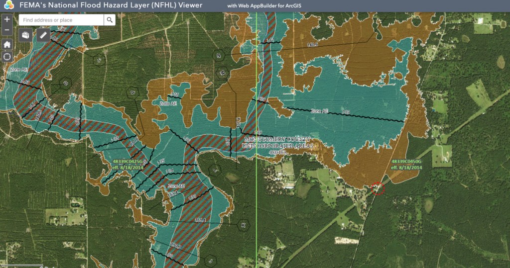
Virtually all of this forest is in some kind of floodplain. See FEMA map below.

Much of Land in Floodplains

FEMA’s National Flood Hazard Layer View shows that large parts of the Signorelli site are in the floodway (striped), 100-year floodplain (aqua) or 500-year floodplain (brown). Photo above this map was taken looking north from red dotted circle.

Keep in mind that the flood map above is based on 2014, pre-Atlas 14 data. The floodplains will expand even further when FEMA updates the flood map.

Current Residents Worry About Development’s Impact on Flooding

I talked to one lady today who lived near the clearing (shown in the first drone photo above) for 55 years. She said she never flooded in all that time. But she worries that she will now. She understood intuitively how the acceleration of runoff from developments, if not properly mitigated, can result in higher flood peaks. She also worried that changes to the slope of the land around her might funnel water toward her property, just as Valley Ranch did to some surrounding homes and businesses.

Only time will tell if her fears are founded. Based on the FEMA flood map above, it appears that Signorelli will need to move a significant amount of earth to elevate homes above floodplains. Signorelli will also likely need to create many detention ponds for an area this large.

Say Goodbye to the Era of Country Retreats

One thing is certain, however. The era of country retreats in this area is history.

The Houston Business Journal published an article on the Signorelli development last week. It listed seven new master-planned developments going in nearby. But the list didn’t even include the closest two, Townsend Reserve and Splendora Crossing on FM2090, about a mile to the southeast and immediately south of Splendora High School. Those have already consumed at least another thousand acres of forest. More on those tomorrow.

Posted by Bob Rehak on 6/5/2022

1741 Days since Hurricane Harvey

Developer Seeks City Approval to Expand Commons of Lake Houston into Floodplain – Without Detention Ponds

Clarification: General plans, as described below, are primarily about street layouts. However, many people have been trying to raise awareness at the Planning Commission that street patterns are affected to a significant degree by the volume and and layout of drainage and detention features. And, of course with Atlas 14 that is more true than ever. Danny Signorelli, CEO of the Signorelli Companies, took issue with this post. I offered him an opportunity to print a rebuttal verbatim. He refused the offer.

Signorelli Companies have filed a general plan with City of Houston Planning Commission for a new development on the San Jacinto East Fork. It’s called “Crossing at the Commons of Lake Houston.”

Second Time Around for Developer

According to residents in other parts of the Commons, Signorelli tried to develop this property before and reportedly wanted to add 4-6 feet of fill to the floodplain. It’s not yet clear what they have in mind for this iteration of the project. However, comparing the general plan to FEMA’s National Flood Hazard Layer Viewer shows that parts of the development are still in the flood plain. (See below.)

No Detention Ponds Shown on Plans

The general plan filed with the planning commission also shows that the developer shows no plans for detention ponds on the property. A best practice to reduce flooding is to “retain your rain.”

General plan filed with the City of Houston Planning Commission shows no detention ponds. For a large, high res PDF, click here.

Location

Here are satellite and close-up views of where the new subdivision would be relative to the the surrounding area and existing parts of the development.

Crossing At the Commons of Lake Houston is in the Huffman area opposite Lake Houston Park and East End Park on the west side of the East Fork.
Crossing at the Commons of Lake Houston relative to existing streets in the Commons. From General Plan inset.

Floodplain Issues

Parts of the proposed development will be in the floodplain. And those floodplains will soon expand to include even more homes. See the two dotted lines below.

Close up of PDF above shows how 100-year floodplain (dotted line on left) and 500-year (dotted line on right) would impact proposed homesites. Note the drainage easement in the lower left.
FEMA’s National Flood Hazard Layer Viewer shows parts of the proposed new 75.3-acre subdivision would be in the 100- and 500-year floodplain.

Ironically, just last night, the City of Houston and its partners (Harris County Flood Control, Montgomery County and the SJRA) presented a draft of the findings of the San Jacinto River Master Drainage Plan. In it, they recommended avoiding flood plain development to keep people out of harm’s way. See slide below from their presentation.

Slide from San Jacinto River Master Drainage Plan Draft Report shows how adding fill to flood plains can affect other homes in area.

The presenter also discussed how the floodplains were expanding due to revisions of flood maps based on new hydraulic and hydrologic modeling not yet been shared with FEMA.

The 100-year floodplain in many areas will likely expand well into the 500. And the 500-year flood plain will likely expand into areas previously not shown in ANY floodplain.

San Jacinto River Master Drainage Plan Draft Report 8/13/2020

Thus, the number of homes affected by floods could greatly expand beyond the number shown above.

Drainage in Commons Already a Problem

Plans also show that homes will be built very close to a drainage easement. Yet existing ditches in the Commons are eroding badly due to lack of maintenance. Below is a picture of one taken in January last year. Residents say the trees are still there and the erosion became much worse during floods in May and Imelda.

Commons drainage ditch photographed last year.

Less Than One Fourth of Property Now Under Consideration

The tract is 332 acres, but only 75.3 is proposed for development at this time.  It is entirely located within the incorporated limits of the City of Houston. The entire tract is adjacent to COH flooding easements for Lake Houston. 

How to Voice Concerns, If You Have Them

Here’s how you can voice concerns, if you have them. The City Planning Commission will hold virtual meetings until further notice. So it’s very easy to make public comments. You can sign up to speak by going to the Planning Commission Home Page.

The next Planning Commission meeting is Thursday, August 20, 2020. If you’d like to speak, you must sign up at least 24 hours before the meeting.

Use the online speaker form at https://www.tfaforms.com/4816241 or submit comments on an item via email to speakercomments.pc@houstontx.gov.

Speakers have only TWO MINUTES. Key points to consider:

  • Floodplain will officially be expanding soon.
  • Some of these homes are already in it.
  • Many more soon will be.
  • That could require fill.
  • And fill will make flooding worse for other homes near the river on both sides.
  • No detention ponds or drainage plans are shown.
  • The Planning Commission should consider these things.

Posted by Bob Rehak on 8/14/2020

1081 Days since Hurricane Harvey

The thoughts expressed in this post represent opinions on matters of public concern and safety. They are protected by the First Amendment of the US Constitution and the Anti-SLAPP Statute of the Great State of Texas.