Two days ago, I wrote about San Jacinto East Fork Flooding at FM2090 in Plum Grove. Yesterday, floodwaters were peaking downstream at FM1485/SH99. No homes were threatened that I saw, but at least one vehicle stalled and was abandoned.
Pictures Taken on 4/10/23 Just After Peak
See the pictures below that I took Monday afternoon when the river was at 63 feet.
Looking west along SH99 at the San Jacinto East Fork where FM1485 parallels the Grand Parkway.
Note the difference in the width of the spans in these bridges. The newer bridge is at least 5X wider. Because water flows right to left, this creates a bottleneck that causes the roads in this area to go underwater frequently. TxDoT probably needs to widen the 1485 bridge or elevate the roadway or both.
Looking east. Upstream (left) of the 1485 bridge, the East Fork remained placid. But downstream, you can actually see the currents in the rushing water.Looking east from over eastbound FM1485 as vehicles attempted to plough through water. Note the black car stalled at the side of the road farther up. That one didn’t make it.Looking west at same location. Despite the dangers, vehicles persisted through the water. There was no room for them to turn around.
As of this writing (noon on 4/11/23), SJRA has scaled back its releases from Lake Conroe to about 1000 cubic feet per second (CFS).
Caution to Swimmers and Waders
Swimming or wading in floodwater can endanger your life. A cubic foot of freshwater weighs about 62 pounds. Rapidly moving water that rises above knee level has enough force to easily knock adults over and sweep them downstream.
The East Fork at FM1485 is still moving at more than 4000 CFS!
So swimmers and waders beware. This morning a reader wrote me about a woman and her daughter who were killed in the East Fork after Harvey. The woman could not battle the current. Her daughter tried to save her and both died.
Understand also that floodwaters can easily scour the riverbed to create drop-offs in unexpected places. Even if you could safely wade in areas before the flood, after the flood, you could easily step into holes over your head.
If you find yourself swept up in a strong current, don’t try to swim against it. Swim perpendicular to it or with it to reach shore.
Certainly, there are many honorable developers who try to build high-quality communities for people without adversely affecting downstream residents. I don’t wish to malign a whole profession. Nor do I want to fail to acknowledge the many wonderful communities they have built in this area.
But there are also some developers who put profit before people. They try to cut corners wherever they can and hope that nobody will notice. Especially regarding flood control. It’s expensive and easy because most people don’t understand it.
Grand Parkway Coming Soon To Wetlands Near You
The construction of State Highway 99, aka the Grand Parkway, has opened up vast new areas on the outskirts of Houston to developers. Many of those areas consist of wetlands and forests.
TxDoT is currently prepping land for Section H of the Grand Parkway almost all the way to FM 1960 on the east from US59.
From USGS. Wetlands near the path of Grand Parkway extension. Compare with maps above and below.
Visible Difference in Development Density Where SH99 Completed
The map below shows permit applications in the north Houston area. Compare the density of projects around sections of the Grand Parkway that have already been completed (left) with the areas on the east where the concrete has not yet reached.
This map shows permit applications in the northeast Houston area, both within the City and its ETJ (extra territorial jurisdiction. The Colony Ridge development featured below is outside the ETJ (green area) in the upper right of the map above.
Developers have even more projects underway outside the City’s ETJ (not shown on the map above).
How Development Can Affect Flooding
Kingwood residents have seen how one developer can contribute to flooding hundreds of homes. Last year, Perry Homes clearcut 268 acres north of Elm Grove before installing detention ponds. Hundreds of Elm Grove homes then flooded on May 7 and again on September 19, during Tropical Storm Imelda.
Below are recent photos of a massive 10,000 acre development in Liberty County near Plum Grove. It is about to become a 15,000 development now, thanks in part to Grand Parkway access. And yet it has only one small traditional detention pond.
Detention ponds slow down the rate of runoff to compensate for the loss of trees, wetlands and ground cover that have been replaced by streets and rooftops.
Their goal: to prevent downstream flooding.
Colony Ridge Accounts for All Growth in Liberty County In Last Decade
Colony Ridge can account for all the growth in Liberty County in the last decade. Below are some photos of Colony Ridge and its expansion near Plum Grove. The approach of SH99 will make it more accessible and therefore more attractive (at least from one point of view).
All aerial photos below were taken on 6/126/2020.
Looking north across the Grand Parkway extension toward Colony Ridge in Liberty County near Plum Grove.Just north of the Grand Parkway (upper left), you can see roads going in that will accommodate even more manufactured homes, aka trailer homes.The developer puts in roads, ditches, water and sewer. Fire hydrants? Forget it.
Developer’s Marketing Strategy
The developer tries to pass as many costs along to lot buyers as he can to maximize profit. He targets Hispanics. Residents tell me that sometimes two or three families may live in one of the homes you see here.
Nobody knows the real population of Colony Ridge because many residents are reportedly undocumented and uncounted.
Site work before parking a home is the responsibility of site buyers, many of whom openly burn brush to clear their lots. Like the developer, they’re trying to cut costs.
Land of Fire and the Forgotten
Resident burning brush on his property last Sunday afternoon.Residents aren’t the only ones burning.That smoke you see on the horizon is from dozens of brush fires set by the developer as he continues to clear land.Here’s one still smoldering.At this point, a major storm would bring the potential for uncontrolled erosion,just as it did in Woodridge Village in Montgomery County, above Elm Grove.As dry as it has been lately, the developer is burning brush piles next to woodlands. That increases fire risk. The barren surface also accelerates runoff and erosion, increasing flood risk.Note the haze and plums of smoke on the horizonand the vast expanse of exposed, packed dirt.The smoke is coming from burning piles of brush, such as these. If a fire spread into surrounding woods, local volunteer fire departments would be overwhelmed.No fire hydrants anywhere in sight.
If this were Houston, hydrants would be spaced at a minimum of every 500 feet. A firefighter told me that the spacing often depends of home values and population. Based on population alone, he believes this area should have hydrants.
One Small Detention Pond for 15,000 Acres
The developer has one detention pond (center) for the entire 15,000 acres. He relies on less efficient, in-ditch detention for additional capacity.Note the proximity to SH99 in the upper right.There are no detention ponds anywhere in the new areas being cleared. This is reminiscent of Woodridge Village which contributed to the flooding of hundreds of homes in Elm Grove.But Woodridge was only 268 acres. The developer relies on this and other drainage ditches to double as detention ponds in storms. But at the far end of this ditch……FM 1010 washed out during Harvey and destroyed one of the two major access roads into the development. The in-ditch detention failed. So has the county. The road has been out now for 1025 days, increasing the commute time for residents and the response time for firefighters.
Endless Loop of Construction and Destruction
State Highway 99 represents more than just a third loop around the City of Houston.
SH 99 will bring more developersand more people eager to escape downstream flooding issues.
Tapayer funded roads such as these create endless loops of construction and destruction. They are like a perpetual motion machine. Building one area floods another, causing people to move farther out and the cycle to repeat itself.
No one will admit it’s intentional, of course. The flooding is just a byproduct of greed. Cut a detention pond here. Substitute in-line detention there. Don’t bother planting grass to reduce erosion. Send your problems downstream. Let someone else worry about them.
One Chance
Do all developers think that way? Of course not. Many have principles and wonderful communities to show for them.
That notwithstanding, as one Splendora resident said, “They really only have one chance to get this right. If they screw this up, it will be almost impossible to fix and they will argue over who is going to pay for it for centuries.”
We are at that inflection point now.
Posted by Bob Rehak on 6/19/2020
1025 Days since Hurricane Harvey
The thoughts expressed in this post represent opinions on matters of public concern and safety. They are protected by the First Amendment of the US Constitution and the Anti-SLAPP Statute of the Great State of Texas.
https://i0.wp.com/reduceflooding.com/wp-content/uploads/2020/06/20200616-RJR_3705.jpg?fit=1200%2C800&ssl=18001200adminadmin2020-06-18 21:28:292020-06-18 21:57:39“The Developers Are Coming! The Developers Are Coming!”
TxDOT has recently cleared a vast swath of forest stretching 13 miles east of US59 to lay the groundwork for the next section of the Grand Parkway.
Almost 25X larger than 610 Loop
When complete, the Grand Parkway will form the third ring around Houston.
610 formed the first ring. It has a perimeter of 37 miles and encompasses an area of 94 square miles.
Beltway 8 formed the second ring. It has a perimeter of 87 miles and encompasses an area of 535 square miles.
The Grand Parkway, when complete, will have a perimeter of 180 miles with an area of 2274 square miles.
That’s almost 25 times larger than the Loop 610 ring.
Map of Completed/Incomplete Segments
The TxDOT map below shows the completed (open) and incomplete (under construction) segments of the Grand Parkway (SH99).
More about Section H
Section H runs north and east of the Lake Houston area through sparsely populated areas that drain back toward Lake Houston. The major streams: White Oak Creek, Peach Creek, Caney Creek, San Jacinto East Fork and Luce Bayou.
Here’s a look at the status of construction between US59 and Plum Grove Road. All aerial photos taken March 6, 2020.
Looking east from Monday Hargrave road.Looking east toward Plum Grove Road by the cement plant.Looking east from over Plum Grove Road.Looking southwest toward where the East Fork San Jacinto crosses under FM1485Looking SW toward Redbud Drive (bottom right) across FM1485Looking SW across Caney Creek. That water in the upper left is the northernmost pond of the Triple-PG sand mine.Looking SW while over the intersection of Sullivan Road and Thelma Lane.Looking SW toward East Community Drive from over the Martin Marietta New Caney Yard. That’s the 59 overpass in the far upper right.Looking SW toward Loop 494 cutting under supports for new bridge.Looking south down 494 from over the Grand Parkway.US59 cuts through the upper right of the frame.Looking NE from SW corner of SH99 and US59. (This image taken Jan. 20, 2020.)
One Quarter of Loop Stretches Through 4 Counties
Combined, Segments H and I-1 will stretch 37.5-miles. It will be a controlled-access toll road with intermittent frontage roads from US 59 North (the Eastex Freeway) near New Caney to US 90 near Dayton to I-10 East (the East Freeway) near Mont Belvieu. This segment of the new road will stretch through four countries: Montgomery, Harris, Liberty, and Chambers.
One of the avowed goals of this project: to foster economic development. It’s certainly going to do that. All those people who moved to Porter and New Caney for a rustic lifestyle on large lots nestled away in the woods, will soon see changes. Your new neighbor could be Perry Homes and the next Woodridge Village or Artavia.
https://i0.wp.com/reduceflooding.com/wp-content/uploads/2020/03/20200306-RJR_9900.jpg?fit=1200%2C800&ssl=18001200adminadmin2020-03-26 14:27:422020-03-26 17:12:06Grand Parkway Will Open Vast New Upstream Areas to Development
As we enter 2020, keep your eyes on these stories.
Elm Grove Lawsuits and Mitigation
In 2019, Elm Grove flooded twice with runoff from the Perry Homes/Woodridge Village development in Montgomery County. Hundreds of homeowners sued Perry Homes’ subsidiaries (PSWA and Figure Four Partners) and their contractors.
On 12/17/19, attorney’s for the plaintiffs filed a fourth amended petition. Since the original filing, plaintiffs have named Double Oak Construction and Texasite LLC as additional defendants.
The judge set a jury trial date for July 13, 2020. To date, Perry Homes has done nothing to reduce the threat of flooding from their job site.
The 268-acres clear-cut acres that contributed to Elm Grove Flooding.
That brings us to the subject of mitigation.
What can be done to restore the safety of residents?
Perry Homes has demonstrated no interest in reducing the threat to downstream flood victims.
Protecting homeowners will require massive intervention from an outside source. But who? And how?
I recently learned of two new developments in the Ben’s Branch watershed.
A developer intends to build 18 acres of apartments where the woods adjacent to the new St. Martha Church now stand.
Another developer intends to build hundreds of homes on tiny lots on an 80-acre site just north of St. Martha’s.
These two projects represent dozens of others gobbling up farm and forest land in southeast Montgomery County.
This drainage ditch feeds into Ben’s Branch at Northpark Drive. The 18 acres of trees on the other side of the ditch could soon become apartments.
Businesses such as the St. Martha School and Kids in Action already flooded twice this year. So did dozens of homes along Ben’s Branch.
Additional upstream development has the potential to make flooding even worse. This is like death by a thousand cuts. Residents just don’t have the time or energy to monitor each development to ensure that owners follow rules and regulations for wetlands, floodplains, drainage, etc. Neither evidently does Montgomery County. Which brings us to…
Montgomery County Standards and Enforcement
Montgomery County competes for development by touting its lack of regulations. That’s a huge problem for downstream residents.
Montgomery County still bases flood maps on data from the 1980s.
Large parts of the county remain unmapped for flood hazards.
The County last updated its Drainage Criteria Manual in 1989.
Developers ignore many provisions within it.
County Commissioners voted to leave loopholes open that allow developers to avoid building detention ponds.
The County even paid an engineering company to investigate itself for its role in the Elm Grove Disaster.
You get the idea. If you thought some benign government entity watched over new developments to protect downstream residents, think again. Below you can see the 80-acre site I mentioned above.
Source: USGS National Wetlands Inventory.
Note how it was covered in wetlands. Developers did not ask permission from the Corps to remove them. They just decided on their own that they didn’t need to ask.
Below, you can see how virtually half the site is in a flood zone or floodway.
Here’s how it looks in Google Earth. Developers have already cleared the site.
Developers intend to build high-density homes in the floodplains. They will also build their detention pond in the floodway. Those hazard areas will likely expand when and if the County incorporates new Atlas-14 data into their flood maps.
Layout for Brooklyn Trails development in Montgomery County
None of this seems to bother the leadership of Montgomery County. And that’s a bigger problem than any one development.
In 2020, expect more focus on the decision-making process and decision makers who have created a permissive culture of indifference to flooding problems.
Sand Mines
Sand mines operate so closely to the San Jacinto that their walls frequently break and pour polluted process water into the drinking water for 2 million people. If they get caught, they pay a small fine and continue operating with impunity.
Left: Liberty Materials Mine in Conroe that undercut five pipelines carrying highly volatile liquids. Center: Triple PG mine in Porter where erosion during Imelda exposed one natural gas line and threatens 5 more HVL pipelines. Right: Another Liberty Materials mine that allegedly dumped 56 million gallons of white goop into the West Fork.
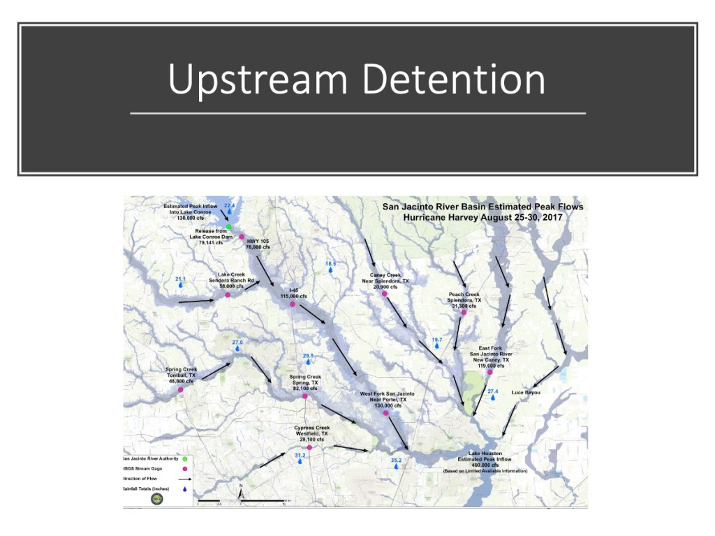
Upstream Detention
During Harvey, the release of 80,000 cubic feet per second from Lake Conroe added to downstream flooding. The goal: to find enough upstream detention capacity to help offset future releases. The San Jacinto River Basin Study will examine that possibility. It’s unlikely that one reservoir will provide enough capacity. However, multiple smaller reservoirs may.
Luckily, State Representative Dan Huberty sponsored legislation that allocated another $30 million. The Harris County Flood Bond allocated $10 million. The City of Houston allocated $6 million. Plus two more grant requests are still pending that could increase the total even more. And a disposal site for the material has already been permitted.
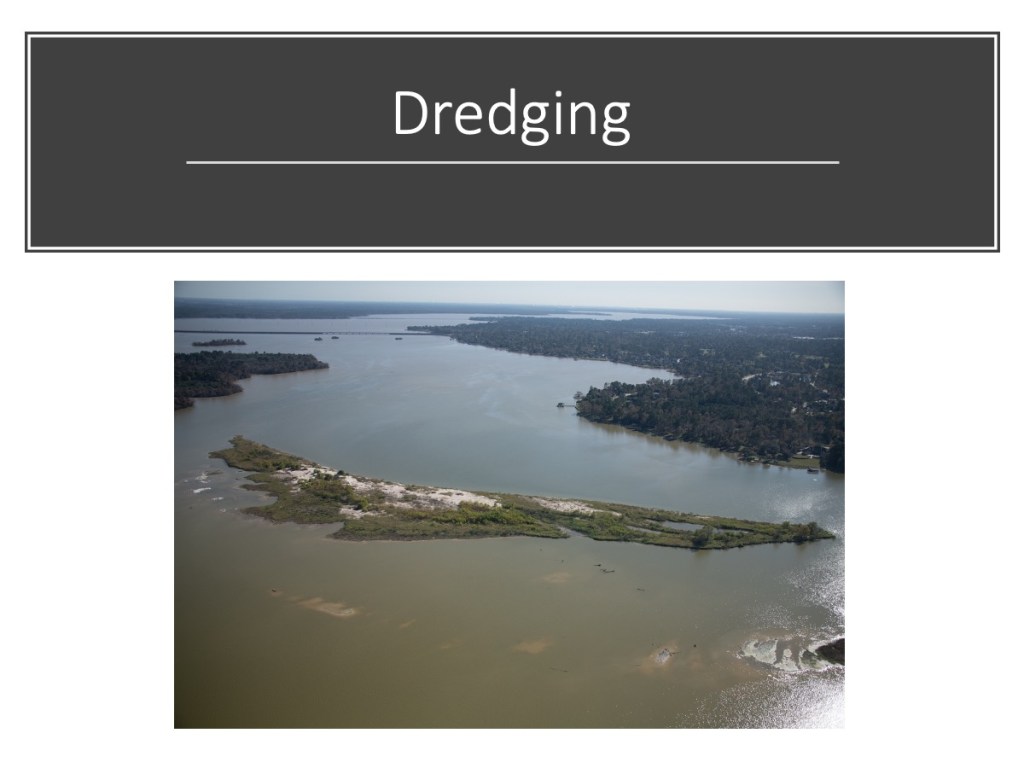
Mouth Bar of the West Fork. Photo taken 12/3/2019.
Last week, Harris County commissioners voted to proceed with additional dredging. Project managers are studying the most cost effective ways to proceed. We should see more dredging soon.
This money could also be used on the growing mouth bar of the East Fork.
State Highway 99 Extension
The extension of the Grand Parkway (State Highway 99) east and south to I-10 will open up vast new expanses of forest and farmland to high density development. The biggest threat will be to the East Fork watershed as construction moves through southeast Montgomery County and the northeast tip of Harris County into Liberty County.
Eastward clearing for SH99 has reached Caney Creek near Lake Houston Park.
Those are my predictions for the biggest stories of 2020. There’s a lot of good news in the forecast and much to remain vigilant about. Life seems to be a constant struggle between those who would increase and decrease our margin of safety when it comes to flooding.
Posted on 12/21/2019 by Bob Rehak
844 Days after Hurricane Harvey
The thoughts expressed in this post represent opinions on matters of public concern and safety. They are protected by the First Amendment of the US Constitution and the Anti-SLAPP Statute of the Great State of Texas.
https://i0.wp.com/reduceflooding.com/wp-content/uploads/2019/12/Slide14.jpeg?fit=1200%2C900&ssl=19001200adminadmin2019-12-21 12:30:522019-12-21 14:37:12Big Stories to Watch in 2020