5/24/26 – What’s wrong with this picture? It shows the confluence of Spring Creek (l) and the San Jacinto West Fork (r).
Confluence of Spring Creek (l) and West Fork on 5/24/26 after several rounds of heavy rain in previous 3 days.
I took it at approximately 3PM today. It has not been retouched. You are looking at the actual color difference in the water coming down the two streams after several days of rain.
However, the heavy rains were almost equally distributed between the two watersheds according to the Harris County Flood Warning System. So, what accounts for the difference? This is important. After all, that’s the drinking water for more than two million people you’re looking at.
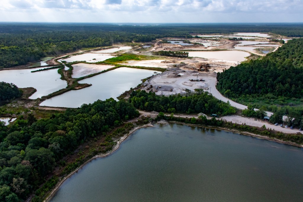
20 Square Miles of Sand Mines in a 20 Mile Reach of the River
A quick look at Google Earth Pro will show a huge difference. There is very little (if any) sand mining upstream on the left, but approximately 20 square miles of sand mines in a 20 mile reach of the river upstream on the right.
And in several mines, the West Fork runs right through active or abandoned sand pits, a phenomenon known as “pit capture.”
So, I drove upstream to learn more. Here’s what I saw.
Water flowing out of a former Hallett pit now owned by Riverwalk Porter LLC. The West Fork enters the pit out of frame to the right.See next shot.Where the West Fork now flows into the Riverwalk pit. Hallett mine in background. River used to flow out of frame in the sandy area on the right, which now totally blocks the river.
Farther upstream, but still at the Hallett mine…
The West Fork flows through another captured pit.Northpark Woods subdivision in background. Pond on the left is an active Hallett pit. Pond in center was formerly owned by Hallett’s parent, the Rasmussen Group, but is no longer actively being mined. Despite that, notice discolored water flowing out of center pit into West Fork.The Hallett Mine exposes several square miles of sediment to erosion.
Another source of sediment from the mine is repairs to its dikes. A local fisherman supplied me with this photo taken today. It shows how repairs to a dike near the processing plant are slumping into the river. I originally posted about the repairs several months ago.
Photo taken on 5/24/26 near Hallett processing equipment.
Here’s what that area looks like from the air.
Note loose, unconsolidated sediment dumped into river near center of frame
Externalizing Operational Costs to Taxpayers
The sand-mining industry in Montgomery County helps power growth there. The bulk of the mines are located close to the Harris County line. So Montgomery County gets the benefit. And Harris County gets the cleanup costs in the form of dredging, water treatment, and medical bills.
TCEQ monitors this mine for Nitrate + Nitrite N, total suspended solids, pH, and hazardous metals including Arsenic, Barium, Cadmium, Chromium, Copper, Lead, Manganese, Mercury, Nickel, Selenium, Silver, and Zinc.
Ask your favorite AI program what the health risks of exposure to those chemicals are.
This is what economists call an “externality.” The full cost of providing the sand is not reflected in the bills that purchasers receive. Miners pass their clean up costs on to taxpayers downstream in order to provide an artificially low cost to the actual consumers.
And in my opinion, that’s what’s wrong with the picture.
Posted by Bob Rehak on 5/24/2026
3190 Days since Hurricane Harvey
The thoughts expressed in this post represent opinions on matters of public concern and safety. They are protected by the First Amendment of the US Constitution and the Anti-SLAPP Statute of the Great State of Texas.
https://i0.wp.com/reduceflooding.com/wp-content/uploads/2026/05/DJI_20260524145751_0210_D.jpg?fit=1100%2C619&ssl=16191100adminadmin2026-05-24 19:21:342026-05-25 09:33:44What’s Wrong with This Picture?
The design of the Lake Houston Spillway doesn’t facilitate sediment discharge.
Lake Houston provides water for millions of people and loss of storage capacity is critical
Consequences of Sedimentation
This combination of factors is not unique, but it is unusual in its magnitude and consequences. Here’s why.
Lake Houston has a 3,160 foot long fixed height spillway for its primary discharge feature.While common in older water supply reservoirs, it provides few flood-control benefits.Studies to add tainter gates are not yet complete.
There is no way to remove sediment from Lake Houston except by dredging. Texas Water Development Board studies show that the lake has lost about 20% of its original storage capacity.
But the total storage loss is not the only issue; also consider where the loss is. Most sediment concentrates in the headwaters of the lake upstream from the FM1960 causeway where the river slows down as it meets a standing body of water.
Deceleration causes sediment to drop out of suspension. A delta has formed at this location, creating a hydraulic chokepoint that backs water up.
The Army Corps dredged approximately 2.1 million cubic yards from the area above FM1960.
Looking S over West Fork mouth bar after Harvey and before dredging.
East Fork Mouth Bar after Imelda, but before dredging
We have seen what happens when we ignore sediment buildups. Thousands of people can lose homes and businesses in a major flood.
Need for Ongoing Sediment Removal and Preservation
The SJRA has studied sedimentation and sand traps for years to help control such buildups. But they have yet to implement any solutions.
Thankfully, a bill by State Representative Charles Cunningham created a Lake Houston Dredging and Maintenance District during the 2025 legislature. That should help manage sediment buildups in the future before they become critical.
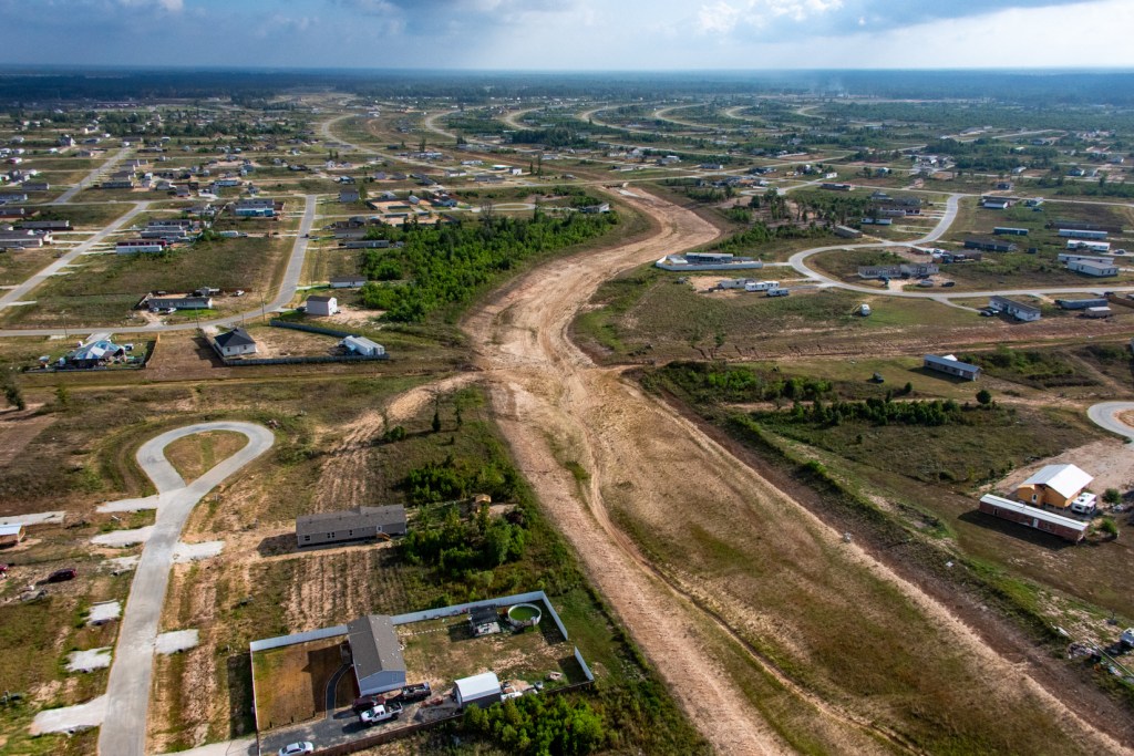
5,300 flood-prone acres between the confluence of Spring Creek (l) and the San Jacinto West Fork (r) are slated for development by Scarborough, a Dallas-based developer and the Texas General Land Office. Note first of many upstream sand mines in upper right.
The area above borders 20-square miles of West Fork sand mines.
The loss of forests due to mining exposes more sediment to erosion during floods.
The loss of forests and riparian buffers leads to a triple whammy in terms of sedimentation. It increases the natural rate of erosion. It costs taxpayers hundreds of millions of dollars to remove it. And until they do, it increases flood risk.
As sand production on the West Fork winds down, now is the perfect time to discuss creating a Montgomery County Lake District or a new state park in this area. It could turn into a win/win for upstream and downstream interests.
For More Information
For more about the causes of flooding and how they can compound each other in the Lake Houston Area, see the Lessons Page.
Posted by Bob Rehak on 4/10/26
3146 Days since Harvey
The thoughts expressed in this post represent opinions on matters of public concern and safety. They are protected by the First Amendment of the US Constitution and the Anti-SLAPP Statute of the Great State of Texas.
https://i0.wp.com/reduceflooding.com/wp-content/uploads/2026/04/DJI_0724.jpg?fit=1200%2C900&ssl=19001200adminadmin2026-04-10 12:19:232026-04-10 17:22:12How Sediment-Induced Loss of River Conveyance Increases Flood Risk
4/9/2026 – Another “lesson learned” about flooding since Hurricane Harvey has been role of sedimentation from industrial-scale sand mining upstream from Lake Houston. It can only be appreciated from the air.
May 2024 flood at Hallett Mine on San Jacinto West Forknear Northpark Drive in Kingwood.Note the difference in water quality in the ditch.
Few, if any, urban watersheds have such dense clusters of sand mines directly upstream from their water reservoirs in major river channels. This is one of the most distinctive features of flooding in the San Jacinto Watershed.
The mines not only contribute to flooding in an outsized way, they impair water quality, damage the environment and harm wildlife.
Chronic Sediment Mobilization During Floods
Most erosion happens during floods. And most sediment moves during floods.
More than 20 square miles of sand mines in the floodway and floodplains of the San Jacinto immediately upstream from Lake Houston provide a ready source of exposed sediment, ripe for mobilization.
I have photographed:
Sand mines pumping sediment over and through dikes
Dike failures.
Rivers capturing sand pits during floods
Mines dumping sediment directly into rivers
See a small sampling of photos below.
LMI sand mine on West ForkBreach of sand-mine dike into San Jacinto West ForkBreach of Triple PG mine dike into Caney Creek in East Fork Watershed. Mine dumping sediment in West ForkSame mine overflowing onto neighboring properties and then West ForkPit capture at Hallett Mine. River now flows through mine instead of around it.FM2090 is now threatened by the East Fork which has rerouted itself through an abandoned sand mine.Pipelines carrying highly volatile liquids undercut by erosion from sand mine on West Fork.East Fork Sand Mine undercutting more pipelines and leaking into Caney Creek Abandoned sand mine equipment leaking oil into West ForkRusting dredge in abandoned sand mine in Humble on North Houston AvenueConfluence of Spring Creek and West Fork in August 2019. TCEQ cited Liberty Mines for discharging 56 million gallons of white sludge into the West Fork.Sand freshly deposited during Harvey blocked West Fork 90%, according to Army Corps. Farther downriver, a mouth bar blocked the West Fork backing water up into thousands of homes and businesses. Army Corps has since dredged this.
The Houston area certainly isn’t the only place in the U.S. with alluvial floodplain mining. But rarely, if ever, do such practices take place with such impunity so close to the water supply for two million people.
For More Information
See the sand-mining page of this website for Best Practices in the U.S. and abroad; academic studies on sand mining; Texas sand mining laws/regulations; observations; and tax appraisal practices. An investigation found that virtually all of the sand mines shown above are in Montgomery County which taxed them as ag- and timberland rather than depleting assets.
Also search on the tag “sand mining” to find more than 300 posts containing thousands of pictures of mining practices in the San Jacinto River Basin.
Posted by Bob Rehak on 4/9/26
3145 Days since Harvey
The thoughts expressed in this post represent opinions on matters of public concern and safety. They are protected by the First Amendment of the US Constitution and the Anti-SLAPP Statute of the Great State of Texas.
https://i0.wp.com/reduceflooding.com/wp-content/uploads/2019/11/RJR_4154-e1775771233982.jpg?fit=1100%2C733&ssl=17331100adminadmin2026-04-09 16:19:172026-04-09 16:47:27Role of Industrial-Scale Sand Mining in Lake Houston Area Flooding
Flat terrain is one of the most under-appreciated aspects of flood risk. It complicates virtually every aspect of flood control.
Flat terrain increases flood risk primarily by reducing the speed of runoff. It causes water to pool rather than drain away. Also, lack of gradient lets floodwaters spread wider, increases sedimentation, backs water up into storm sewers, and creates unpredictable backwater effects.
Spreading Wider
In steep, mountainous areas, a one-foot rise in a river can be relatively contained; it won’t spread out much. But in flat areas, water spreads out easily. Even a slight rise in water level can submerge numerous properties. And that water may not drain away quickly. As water fills channels, it backs up water into storm sewers and may cause street flooding.
Increases in rainfall can also shift floodplain boundaries significantly, as we saw recently with the introduction of new draft flood maps based on Atlas 14. Homes once considered outside of floodplains are now within them.
Increasing Sedimentation
Flat terrain also makes rivers move slowly. This enables suspended sediment to settle and reduces a river’s capacity to convey stormwater, leading to more frequent flooding.
It can also lead to the creation of sand bars, especially where rivers meet standing bodies of water, such as Lake Houston. During Harvey, we saw “mouth bars” grow thousands of feet on the East and West Forks above Lake Houston.
San Jacinto West Fork Mouth Bar after Hurricane Harvey
Mouth bars are sand bars found at the mouths of rivers. Such blockages create partial sediment dams that back water up and promote even more deposition upstream. For instance, see below.
Farther upstream from the West Fork mouth bar, additional freshly deposited sand during Harvey reduced West Fork conveyance by 90% at this location, according to the Army Corps.
The Army Corps has since dredged the West Fork. However, while dredging can temporarily deepen a channel, it does nothing to increase the slope (gradient). Without a steeper slope, the river remains slow, and new sediment quickly refills the dredged areas.
In steep river systems, flood waves pass quickly. But in Southeast Texas, flood waves move slowly down rivers. Peaks linger and lengthen. This increases the probability that the peaks will synchronize, i.e., stack on top of each other.
That’s especially true in large storms, such as hurricanes, that may stall over an area for days and dump rain uniformly across the region. Stormwater peaks from different tributaries then stack on top of each other as they moves downstream.
The highest flooding in Harris County during Harvey occurred at the confluence of Spring Creek (L) and West Fork (R). Looking NW from over I-69 Bridge.
Other Backwater Effects
The low gradient of streams in southeast Texas makes them extremely sensitive to a variety of backwater effects.
In flat river basins like the San Jacinto, Trinity and Brazos, mild slopes amplify “backwater effects.” Examples include
Bridges, culverts, sand bars, levees, dikes, and new developments
Can constrict conveyance and back water up
Same confluence as shown above but from a different angle shows how floodplain fill is constricting floodplain storage and the floodway near a critical choke point, the I-69 Bridge
Implications for Policy Making
In low gradient systems, many streams become hydraulically coupled during floods. So, basin-wide coordination is essential.
West Fork sand mine frequently inundated by floods illustrates need for vegetative controls to reduce erosion.
Summary
To summarize, in flat coastal plains with low-gradients:
Low slope = low velocity = poor drainage
Water spreads laterally instead of moving quickly downstream, flooding many structures
Stormwater from different tributaries has a higher chance of stacking up
Sediment accumulates faster
Infrastructure bottlenecks can have large spatial impacts.
Posted by Bob Rehak on 4/7/26
3143 Days since Harvey
The thoughts expressed in this post represent opinions on matters of public concern and safety. They are protected by the First Amendment of the US Constitution and the Anti-SLAPP Statute of the Great State of Texas.
1/11/2026 – At the end of 2025, the San Jacinto River Authority (SJRA) issued an update on the status of four flood-mitigation projects. During Hurricane Harvey and again in May 2024, SJRA came under withering criticism for releases from Lake Conroe exceeding 70,000 cubic feet per second that flooded downstream residents.
The four projects represent different ways to offset similar releases in the future and their adverse effects. They include:
The City of Houston is currently performing a project to add new spillway gates to increase the controlled release capacity of the Lake Houston dam. The goal of this Joint Reservoir Operations Study is to determine the most efficient and safe operation of Lake Conroe in series with Lake Houston once the new gates are installed.
The study will evaluate the feasibility of prereleases including impacts on water supply. The study will also develop a forecasting tool for Lake Houston and support development of the gate operations policy for the proposed Lake Houston dam gates.
Black & Veatch is handling the million-dollar study for SJRA, City of Houston, City of Humble and the Texas Water Development Board. The engineering company received a notice to proceed in August 2025 and expects to complete the project by December 2027.
Black & Veatch is also handling the engineering for the City of Houston on the project to add more flood gates to the Lake Houston Dam. The company has completed preliminary engineering. Mayor Whitmire expects them to finish detailed engineering by the end of this year.
For more on the Joint Reservoir Operations Study, see:
This project explored multiple alternative sites for dams along Spring Creek with the potential to reduce flooding. The two most cost effective alternatives were on Birch and Walnut Creeks. SJRA released its draft report to the Texas Water Development Board in June 2025. Its final report is due next month.
For more on the Spring Creek Dams Site Study, see:
Upper San Jacinto River Basin Regional Sedimentation Study
According to the Army Corps, conveyance of the San Jacinto West Fork between Humble and Kingwood was reduced 90% due to sedimentation. That exacerbated flooding. Since then, SJRA has evaluated sedimentation throughout the river basin to learn:
Where the most sediment comes from
How to prioritize watersheds for improvements
Conceptual solutions
The goal: reduce loss of floodway conveyance in the basin.
SJRA started the project in May 2022. It hopes to deliver a draft report to the TWDB by October 2026 and the final report by June 2027.
The sand trap project is one potential way to remove material from the river in order to improve conveyance and reduce the risk of flooding.
SJRA is working with HCFCD and City of Houston to plan, design, and construct one or more “sand traps” along the West Fork.
A major component of the project is coordinating with Aggregate Production Operations (APOs) along the river. A public/private partnership would provide for operation and maintenance of the proposed sand trap(s). A conceptual design effort to select the most feasible site(s) for installation of sand trap(s) has been completed, and preliminary design is scheduled for completion in early 2026.
It’s important to recognize that more than eight years after Harvey, not one of these studies is complete yet. And the studies are just the first step in a multi-step process that includes final engineering, funding, land acquisition, and construction for most of these.
At this rate, it could take decades before we see actual flood-mitigation benefits. We really need to find ways to speed up this process.
Posted by Bob Rehak on 1/11/26
3057 Days since Hurricane Harvey
https://i0.wp.com/reduceflooding.com/wp-content/uploads/2019/04/LC-Dam-e1719277556742.jpg?fit=1200%2C549&ssl=15491200adminadmin2026-01-11 19:19:532026-01-11 19:23:35SJRA Update on Status of Four Flood-Mitigation Projects
Harris County Flood Control, SJRA, and the Cities of Humble and Houston using funding provided in part by the Texas Water Development Board are searching for sediment solutions in the Upper San Jacinto River Basin. Their major scientific study includes all or parts of seven counties: Harris, Montgomery, Waller, Grimes, Walker, San Jacinto and Liberty – all land draining into Lake Houston.
From Technical Memorandum 1 of the Upper San Jacinto River Basin Regional Sedimentation Study.
The high-level goal: to better manage sediment in the river basin. Sediment reduces both floodway conveyance and the storage capacity of Lake Houston. Both contribute to the frequency and severity of flooding.
Among other things, the study partners hope to prioritize sediment hot spots so they can develop sediment solutions and recommendations.
I hope they look at Colony Ridge. It exemplifies a major hot spot and points the way to an obvious sediment solution – better enforcement of existing regulations.
Scope and Status of Sediment Study
The study is now about half complete. With much of the fieldwork complete, the partners will next focus on modeling, hotspot identification, area prioritization and sediment solutions, according to Matt Barrett, Water Resources and Flood Management Division Manager atSJRA.
To date, the study has examined a variety of factors:
Sediment Solutions Must Address Development Practices
Erosion occurs naturally. But poor development practices can accelerate the rate of erosion unnaturally.
Regulations in Liberty County call for backslope interceptor swales to prevent sheet flow over the sides of ditches. I have yet to see one such system anywhere in the 30+ square miles of Colony Ridge. What you typically see is this.
All that sediment washes downstream where it reduces the carrying capacity of rivers and the storage capacity of Lake Houston.
Liberty County regulations also call for planting grass on the side slopes of ditches and detention basins. The grass reduces erosion, too. But you don’t see much grass on those side slopes either.
Compare the ditch above with the ditch below in Harris County to see how grass and backslope interceptor swales can reduce erosion.
Small swales behind main slopes capture sheet flow heading toward the ditch. Pipes then take runoff to the bottom of ditch, thus reducing erosion on side slopes.
Here’s Colony Ridge again.
Three-mile-long Colony Ridge drainage ditch has no grass or backslope interceptor swales.
Address the Elephant in the Room Before the Next Disaster
Ironically, both Liberty and Harris County have almost identical regulations for erosion control. Harris County enforces them; Liberty County doesn’t.
Enforcement of development regulations is the elephant in the room.
So, as the SJRA and its partners search for sediment solutions, here’s one simple recommendation. Enforce regulations already on the books.
Colony Ridge and other developments that skirt regulations represent a disaster waiting to happen. Unfortunately, it will probably take a disaster, such as Harvey, to cause leaders to take action. But by then, it will be too late.
Posted by Bob Rehak on 10/20/23
2242 Days since Hurricane Harvey
The thoughts expressed in this post represent opinions on matters of public concern and safety. They are protected by the First Amendment of the US Constitution and the Anti-SLAPP Statute of the Great State of Texas.
https://i0.wp.com/reduceflooding.com/wp-content/uploads/2023/10/20231006-RJR_6038-1.jpg?fit=1100%2C733&ssl=17331100adminadmin2023-10-20 14:08:222023-10-20 17:39:42Search For Sediment Solutions Should Lead Straight to Colony Ridge
Colony Ridge, the world’s largest trailer park, fails to meet Liberty County regulations for the construction of stormwater detention basins and ditches. The development’s basins and ditches routinely lack erosion controls such as grass and backslope interceptor swales. The resulting erosion can reduce the conveyance of streams, increase flood risk and threaten property both inside the development and downstream. The failure to follow those regulations imposes a hidden tax on residents of Liberty and surrounding counties.
Pages 152 and 153 of the regulations also require backslope drain systems to “intercept sheet flow which otherwise would flow over the banks of drainage channels leading to erosion of the side slopes.” Swales behind the edges of basins and channels trap stormwater. Pipes then carry it to the bottom of the ditch or basin so that it won’t erode side slopes.
What Ditches/Detention Basins Should Look Like
The photo below shows a Harris County ditch with grass on the side slopes and pipes that lead from backslope swales to the bottom of the channel. Note how they reduce erosion and sedimentation.
Harris County ditch which follows regulations similar to Liberty County’s. Compare the Colony Ridge ditches below.
Compare Requirements to Photos
I took the pictures below on 8/12/23 from a helicopter while flying over Colony Ridge in Liberty County. Note the lack of grass and interceptor inlets/outlets. Also note the severe erosion that results.
Note severe erosion on banks of pond. Also note lack of backslope swales, inlets, and outlets in base of pond.No backslope interceptor system. No grass.No backslope interceptor system. No grass.No backslope interceptor system. No grasson sides of ditch.Ditto.Ditto
In some cases, the ditches and detention basins don’t even have perimeter maintenance roads and the erosion is cutting into people’s back yards.
Colony Ridge resident losing back of property due to ditch erosion.
The Largest Development Few Know About
Colony Ridge is large and growing rapidly. The satellite image below shows how it has virtually doubled in size within the last two years as it has grown from left to right and bottom to top. The large area in the lower left began developing around 2011. Those lines that look like hashmarks are thousands of mobile homes.
This satellite image taken in July 2023 does not even show the development’s current extent. Much of the area in the upper right below the clouds was cleared since then.See below.Portion of Colony Ridge in upper right of satellite photo has now been cleared.
Colony Ridge already comprises more than 30 square miles. That makes it approximately one third the size of the area inside Houston’s 610 loop.
Mostly mobile homes and rivers of mud as far as the eye can see.
Erosion a Major Issue
Colony Ridge drains into three watersheds: the East Fork San Jacinto, Luce Bayou and Tarkington Bayou. And all of them drain into Lake Houston. That will make erosion from Colony Ridge Harris and Liberty County’s problem forever.
“Erosion and sedimentation can have very serious effects on storm water drainage.”
“Erosion can cause slope failures, increase roughness coefficients, and generally reduce the efficiency of drainage channels. However, sediment deposition can clog drainage culverts and reduce the available conveyance in open channels.”
“Erosion can significantly reduce the maintainability of drainage facilities and increase the cost of maintenance by increasing the frequency with which repairs are required.”
LJA engineering wrote a letter to the Liberty County Engineer that underscores the need to plan ahead as the county transitions from rural to urban. “While limited regulation of development in a rural area may not significantly impact drainage issues, Liberty County is now challenged with explosive population growth and a particularly high percentage of socially vulnerable residents…” said the letter.
Hidden Cost to Downstream Residents
Most people in Harris County don’t even know that Colony Ridge exists. Yet the drainage practices there affect dredging costs downstream. The City of Houston, Harris County and Army Corps spent almost a quarter billion dollars dredging the headwaters of Lake Houston between Harvey and mid-2021.
Clearly, not all of that sediment came from Colony Ridge. However, the development practices in Colony Ridge and other developments like it will set the pattern for the future.
Developments are virtually impossible to change after people start building next to undersized basins and ditches that erode more with every substantial rain.
What You See Makes You Question What You Don’t See
Substandard construction practices make you wonder about engineering practices. Did Colony Ridge engineers produce reliable, accurate estimates of drainage needs? Are those ditches and detention basins sized properly? Will they hold enough runoff to protect residents?
Probably not. Even assuming engineers and contractors did their jobs properly (a big assumption), Liberty County still defines a 100 year/24 hour rainfall as 13.5 inches (see page 108), a rate associated with pre-Atlas 14 days.
Atlas 14 catalogs the current national precipitation frequency standards for every community in the U.S.
However, the phrase “Atlas 14” appears nowhere in the 2019 Liberty County Subdivision and Development Regulations.
But NOAA now defines a 100 year/24 hour rainfall for nearby Cleveland, TX, as 17.1 inches – a 27% increase above the current Liberty County standard. So in a hundred-year rainfall, everything you see in Colony Ridge will be 27% short of capacity. Few people likely understand this.
Consider also that NOAA is already working on replacing Atlas 14 with Atlas 15!
Posted by Bob Rehak on 8/16/23
2178 Days since Hurricane Harvey
The thoughts expressed in this post represent opinions on matters of public concern and safety. They are protected by the First Amendment of the US Constitution and the Anti-SLAPP Statute of the Great State of Texas.
https://i0.wp.com/reduceflooding.com/wp-content/uploads/2023/08/20230812-RJR_5768-e1692197968560.jpg?fit=1100%2C733&ssl=17331100adminadmin2023-08-16 11:46:552023-08-16 23:01:40Colony Ridge Stormwater Detention Basins, Ditches Fail to Meet Liberty County Standards
The Lake Houston Gates Project is moving closer to reality with breakthroughs on the benefit/cost ratio, funding and endorsements.
City of Houston Mayor Pro Tem Dave Martin and Chief Recovery Officer Stephen Costello provided updates on 2/27/23 at City Hall on the Lake Houston Gates Project. The wide-ranging, hour-long discussion covered several related topics. They included:
A critical path for construction
Dredging of the lake
Funding for gates and dredging
Several related engineering studies
A favorable ruling from FEMA on the Benefit-Cost Ratio
An endorsement to the area’s legislators by the Greater Houston Partnership.
Need For Gates
For those new to the area, the City of Houston has been pushing to add gates to the Lake Houston Dam ever since Harvey in 2017. Upstream, Lake Conroe’s gates can release 150,000 cubic feet per second (CFS). But Lake Houston’s can only release 10,000 CFS.
The disparity in discharge capacity complicates joint-reservoir-management and pre-release strategies designed to avoid flooding by reducing the water level in Lake Houston.
Lake Houston releases cannot keep up with Lake Conroe’s. And pre-releasing water from Lake Houston takes so long that storms can veer away during the lowering process, often resulting in wasted water. That’s an important consideration for a water-supply lake.
According to Martin and Costello, the gate project will:
• Serve as the first phase of a long-term effort to extend the life of the Dam • Enable the rapid lowering of lake levels in advance of a flood • Eliminate the need for a seasonal lowering of both Lake Houston and Lake Conroe • Provide potential water-rights savings • Protect an estimated 5,000 residential properties in the surrounding area • Yield an estimated half billion dollars in economic benefits during the life of the project
However, the City discarded that idea as “too risky” after further study. The engineering company cautioned the City that it would have a difficult time finding contractors willing to risk modifying a 70-year old concrete dam. The potential liability was just too great. So the City then revisited adding various numbers of tainter gates to the eastern, earthen portion of the dam.
Because tainter gates exceeded FEMA’s funding, the City had initially focused on crest gates. But after investigating the safety issues, the City decided to seek more funding for tainter gates instead.
Recommended location for new tainter gates is next to old ones, not farther east as I conjectured earlier.
The picture below is slightly wider and shows more of how both halves of the dam come together.
If funding comes through, new gates would go in the upper right along the earthen portion of the dam, next to the old gates.
Funding Needs
FEMA initially set aside $50 million for the gates. Plus Harris County committed $20 million in the 2018 Flood Bond to attract FEMA’s match. But the latest construction estimates show eleven tainter gates could cost between $200 and $250 million.
After engineering and environmental studies, only $68.3 million in funding remains. That includes an earmark secured by Congressman Dan Crenshaw. So the City is seeking another $150 million from the State of Texas. Martin and Costello have made weekly trips to Austin so far during this session to line up support from legislators, committee chairs, and the Texas Division of Emergency Management.
Social Benefits Improve Benefit/Cost Ratio
All this is suddenly possible because of a favorable ruling from FEMA on the benefit-cost ratio (BCR).
For years, Houston had struggled to get the BCR for the gate project above 1.0 (the point at which benefits exceed costs). Usually, FEMA strictly interprets benefits as “avoided damages to structures.”
But Houston Mayor Sylvester Turner and Costello met with FEMA to argue that the problem was much bigger than damaged structures.
As a result, FEMA allowed the City to add the value of “social benefits” to the BCR. Social benefits can include such things as avoiding lost wages when businesses are destroyed; transportation disruptions that reduce the region’s productivity; reducing negative impacts on student achievement when schools are disrupted; and more.
The social-benefit ruling covers a number of City projects, not just the gates. It should also benefit other areas, especially rural ones.
Said Costello, “The minute the social benefits came in, everything was great.” Instead of struggling to reach 1.0, the City is now far above it.
Greater Houston Partnership Endorsement
With that out of the way, the Greater Houston Partnership wrote a powerful letter to state legislators seeking their support for the gate project. See below.
The Partnership includes business leaders from 900 member companies in the 12-county Houston Region.
Dredging Update
While pressing ahead with the gates project, the City is also working on a long-term dredging plan for the lake and working with the SJRA on sedimentation and sand-trap pilot projects.
The lake has already lost more than 20,000 acre feet of capacity due to sedimentation. That worsens flooding. While the Federal Government supports efforts to improve Lake Houston now, the chances of getting more money in the future will be reduced – unless we can show that we’re at least keeping pace with annual sediment deposits.
Since Harvey, FEMA, the Army Corps, TWDB, and City of Houston have removed almost 4 million cubic yards of material from the lake at a cost of $226 million.
We have to prevent more sediment from coming downstream or dredge it after it gets here.
Stephen Costello, City of Houston Chief Recovery Officer
The City is currently lobbying for another $50 million for maintenance dredging to add to the money secured in the last legislative session by now-retired State Representative Dan Huberty. New Representative Charles Cunningham will reportedly now carry that banner forward along with State Senator Brandon Creighton.
Legislative News to Follow
March 10th is the last day to file bills in the Texas Legislature this year. Please visit the legislation page on ReduceFlooding.com for updates once bills are filed and start moving forward in Austin.
Thanks to all of our elected and appointed representatives who have pushed so hard on so many fronts for the last 2008 days to tie all the pieces of this complicated flood-mitigation puzzle together.
Posted by Bob Rehak on 2/27/2023
2008 Days since Hurricane Harvey
https://i0.wp.com/reduceflooding.com/wp-content/uploads/2023/02/20230227-Screenshot-2023-02-27-at-9.28.29-PM.jpg?fit=1200%2C679&ssl=16791200adminadmin2023-02-27 21:45:512023-02-28 11:45:24Lake Houston Gates Project Moves Closer to Reality
The hand of sand miners weighs heavily on the San Jacinto watershed. Not all miners. But many.
While exploring the river basin by helicopter last week, the contrast between two scenes struck me: 1) The natural blanket of green in Lake Houston Wilderness Park. 2) Sand mines that lined the banks of the East and West Forks for miles.
The trees and natural wetlands inhibit floods. They slow floodwaters down, hold them back during heavy rains, and reduce erosion. The sand mines do not. They may provide some floodwater detention, but the pits are often filled to the brim and their dikes often break.
How you treat the land determines how it treats you. Especially during floods. This aerial photo essay shows how the San Jacinto River Basin used to look and how it looks today.
Lake Houston Wilderness Park
Peach and Caney Creeks border Lake Houston Wilderness Park on the west. The San Jacinto East Fork borders it on the east. The shot below represents the way the whole Lake Houston area used to be.
Looking across the 5000 acres of Lake Houston Wilderness Park – the largest urban nature park in America.
Compare That With These Shots
This first provides a direct comparison.
Sand mine on Caney Creek. Lake Houston Wilderness Park in upper right.
I’ll provide five more shots here, all from the West Fork San Jacinto. They represent more than 500 similar shots I took on 7/22/22.
No Swimming
When I see all this environmental degradation, my mind starts swimming – despite the scary water.
How much sediment gets swept downstream in floods?
Can this land ever return to productive use?
Do other cities allow mining in urban environments upstream from their water sources?
What effect does mining have on the water quality in Lake Houston?
What percentage of our water bills goes to cleaning up this water?
Why doesn’t Texas have performance bonds that ensure sand miners leave the land in habitable shape?
The sand makes concrete. It supports growth. But is all growth good?
Is growth in one area at the expense of public safety in another worthwhile?
Should we limit the concentration of mines in an area?
Why do mines expect the public to pay their cleanup and reclamation costs?
Is it safe to build mines below a dam that releases enough water during floods to break the mines’ dikes?
Are there no alternatives?
Cycle Continues
New Segment H of the Grand Parkway cutting east through forests will attract more subdivisions that require more sand for more concrete.
I encourage rebuttals from any mine owner who wishes to address these questions.
Posted by Bob Rehak on July 27, 2022
1793 Days since Hurricane Harvey
The thoughts expressed in this post represent opinions on matters of public concern and safety. They are protected by the First Amendment of the US Constitution and the Anti-SLAPP Statute of the Great State of Texas.
https://i0.wp.com/reduceflooding.com/wp-content/uploads/2022/07/20220722-RJR_0554.jpg?fit=1200%2C800&ssl=18001200adminadmin2022-07-27 14:03:372022-08-29 15:08:12The Hand of Sand Miners on the San Jacinto
The Colony Ridge development in Liberty County, aka the world’s largest trailer park, has more than doubled in size in the last 3 years. Measurements in Google Earth show that Colony Ridge, which started clearing land in 2012, has expanded from approximately 8,000 acres in 2019 to almost 20,000 acres today. To put that in perspective, Kingwood comprises approximately 14,000 acres and took more than 40 years to build out.
Colony Ridge started developing on the left (west). It is expanding eastand north.
Growing Pains
But the rapid growth of Colony Ridge has not come without pain:
Rivers of mud continue to flow out of drainage ditches with big rains because the developer flaunted construction regulations for them.
Consequences of Poor Construction Practices
As a result of such drainage issues and exposed soils, more sediment flows downstream than otherwise would. This contributed to sediment buildups on the San Jacinto East Fork (see below). Those, in turn, reduce conveyance and contribute to downstream flooding – unless the public continues to spend millions on dredging.
East Fork Mouth Bar after Imelda but before recent dredging. Average river depth had been reduced to three feet.
Still Not Following Best Practices
Aerial photos taken on 7/22/2022 with Ken Williams and Bill Callegari, two fellow members of the Harris County Community Flood Resilience Task Force, show the current state of the development and construction practices in Colony Ridge. Sadly, not much has improved. For instance, the developer still piles dirt on the edge of ditches without protecting them with silt fences.
Note long drainage ditch cutting diagonally through middle of frame. Developer has piled dirt next to it (middle left of frame) without protecting ditch with silt fencing.Major ditch cutting through older section is sill not protected with back-slope interceptor swales or vegetation.Erosion is rampant.
Water shooting down the ditch above created a major headache during Harvey. See below.
FM 1010 Still Washed Out
Floodwater from the ditch washed out FM 1010. This major N/S thoroughfare still needs repair…five years later!
Break in FM 1010, aka Plum Grove Roadforces residents to detour for miles.
Photos Showing New Development
Area developed last year is starting to fill in with new trailer homes already.Note absence of fire hydrants…still.Looking east at area still under construction.Looking E from NE corner of development.Another area semi-cleared but still unpaved.
If there’s good news in these photos, it is that the developer appears to be leaving more natural ground cover in the newest areas. Still, without vegetation on the sides of ditches, without better construction practices, excess sediment could continue washing into the Lake Houston Area for years to come.
Downstream residents will continue to pay the price for egregious development practices upstream.
Someday, the people who buy these lots will also become flood victims of similar new developments even farther upstream.
Will we continue to repeat mistakes of the past in ever widening circles? Will we continue to sow the seeds of future flooding? Or will we wake up to the fact that we are all part of one giant community?
Posted by Bob Rehak on 7/23/2022
1792 Days since Hurricane Harvey
The thoughts expressed in this post represent opinions on matters of public concern and safety. They are protected by the First Amendment of the US Constitution and the Anti-SLAPP Statute of the Great State of Texas.
https://i0.wp.com/reduceflooding.com/wp-content/uploads/2022/07/20220726-Screen-Shot-2022-07-26-at-10.27.55-AM-2.jpg?fit=1200%2C854&ssl=18541200adminadmin2022-07-26 15:04:302022-08-29 15:09:39Controversial Colony Ridge Development Doubles in Size