What’s Wrong with This Picture?
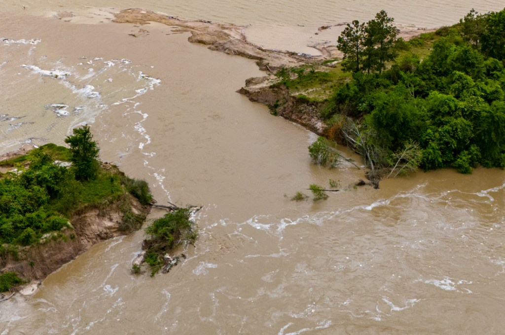
5/24/26 – What’s wrong with this picture? It shows the confluence of Spring Creek (l) and the San Jacinto West Fork (r).

I took it at approximately 3PM today. It has not been retouched. You are looking at the actual color difference in the water coming down the two streams after several days of rain.
However, the heavy rains were almost equally distributed between the two watersheds according to the Harris County Flood Warning System. So, what accounts for the difference? This is important. After all, that’s the drinking water for more than two million people you’re looking at.
20 Square Miles of Sand Mines in a 20 Mile Reach of the River
A quick look at Google Earth Pro will show a huge difference. There is very little (if any) sand mining upstream on the left, but approximately 20 square miles of sand mines in a 20 mile reach of the river upstream on the right.
And in several mines, the West Fork runs right through active or abandoned sand pits, a phenomenon known as “pit capture.”
So, I drove upstream to learn more. Here’s what I saw.


Farther upstream, but still at the Hallett mine…


Another source of sediment from the mine is repairs to its dikes. A local fisherman supplied me with this photo taken today. It shows how repairs to a dike near the processing plant are slumping into the river. I originally posted about the repairs several months ago.

Here’s what that area looks like from the air.

Externalizing Operational Costs to Taxpayers
The sand-mining industry in Montgomery County helps power growth there. The bulk of the mines are located close to the Harris County line. So Montgomery County gets the benefit. And Harris County gets the cleanup costs in the form of dredging, water treatment, and medical bills.
TCEQ monitors this mine for Nitrate + Nitrite N, total suspended solids, pH, and hazardous metals including Arsenic, Barium, Cadmium, Chromium, Copper, Lead, Manganese, Mercury, Nickel, Selenium, Silver, and Zinc.
TCEQ Report
Ask your favorite AI program what the health risks of exposure to those chemicals are.
This is what economists call an “externality.” The full cost of providing the sand is not reflected in the bills that purchasers receive. Miners pass their clean up costs on to taxpayers downstream in order to provide an artificially low cost to the actual consumers.
And in my opinion, that’s what’s wrong with the picture.
Posted by Bob Rehak on 5/24/2026
3190 Days since Hurricane Harvey
The thoughts expressed in this post represent opinions on matters of public concern and safety. They are protected by the First Amendment of the US Constitution and the Anti-SLAPP Statute of the Great State of Texas.