Friendswood Development Company has started clearing 553 acres west of Huffman-Cleveland Road. It will eventually extend from Northwood County Estates on the north to Cypress Point on the south. Plat records show that Friendswood has named the development “Sila.”
Long, Narrow, Dense Homesites
The new residential community will contain an unspecified number of homesites, most long and narrow. This will certainly increase the percentage of impervious cover relative to the surrounding area.
Detail from Sila Section 3 plat approved by Houston Planning Commission in 2023.
Existing homes sit on larger, heavily wooded lots. So, this and other new, nearby developments will change the character of the area considerably. Along with that will come more traffic and congestion.
To put that in perspective, I talked to one homeowner in nearby Northwood Country Estates who owns a five-acre lot.
Forty-five of the lots indicated above could fit on his property.
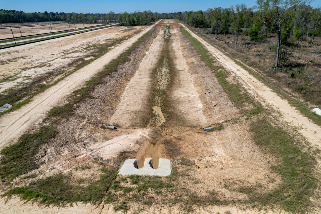
Drainage Plans
Friendswood appears to be almost halfway done with clearing land for Sila. Consistent with best practices and construction plans, contractors appear to be clearing one section at a time, installing perimeter catchment ditches, erecting silt fence, and stabilizing land before moving on to the next area.
Detail from Sila drainage impact analysis.
The drainage analysis also claims that the development will provide more than the minimum amount of required detention-basin capacity. The minimum required is .65 acre feet per acre. But the engineering firm BGE says it will provide .67.
The minimum requirement was established by Harris County Flood Control District in 2019 after Hurricane Harvey. So, it should accommodate 100-year rainfalls projected under Atlas 14, NOAA’s current standard for rainfall estimates.
Approximately the northern half of this area has been cleared to date.
Approximately Half of Land Cleared So Far
The pictures below, all taken on 2/3/24, show the areas cleared so far.
Looking west over Huffman-Cleveland Road at extent of clearing. Curvature in road is caused by wide-angle-lens distortion.
The yellowish runoff in the foreground of the photo above is from Saint Tropez another new, but different development seen in the background of two pictures below.
Note the ditches that channel runoff away from homes in Northwood County Estates in upper right.
A 1.5 inch rain the night before I took these photos caused the ponding water you see.
Reverse angle. A series of three connected stormwater retention basins will flank the main entry road. Area to right (south) has not yet been cleared.Looking east toward Saint Tropez across Huffman-Cleveland Road.Friendswood appears to have planted grass in foreground to reduce erosion.Silt fence protects neighbors in other areas cleared earlier.
Proposed Lake Houston Mitigation Bank
The Sila property will drain into hundreds of acres that are part of the proposed Lake Houston Mitigation Bank.
Looking W at wetlands and floodplain between Sila and the East Fork San Jacinto.
East Fork San Jacinto River and Lake Houston Park beyond.
The preservation of so much land will help protect homebuyers from flooding. It will also provide wildlife habitat and an exceptional recreational amenity. Here’s the prospectus for the mitigation bank presented to the Army Corps. Corps approval still appears to be pending as of this writing.
Areas of Concern
Two areas of concern, however, exist near the land most recently cleared. Contractors have not yet erected silt fence or dug protective ditches behind some of the neighboring homes on Davidson Lane in Northwood County Estates.
Looking S. Neighboring homes in upper right were still unprotected from runoff when I took this picture on 2/3/24. Water flows from left to right toward East Fork San Jacinto out of frame on the right.Looking W. Note how runoff is draining across neighbor’s property. A larger rain could have caused damage.
Neighbors in Northwood County Estates are also concerned with how existing drainage will tie into Sila’s drainage. Elevations on county drawings and Sila’s drawings differ in places. So residents are asking for confirmation that existing ditches will continue to drain properly.
Ditch at end of Davidson Lane in Northwood Country Estates.
For the most part, with the exceptions noted above, Friendswood seems to be responsibly navigating the perilous early phase of development between clearing and the installation of drainage.
Posted by Bob Rehak on 2/4/24
2250 Days since Hurricane Harvey
The thoughts expressed in this post represent opinions on matters of public concern and safety. They are protected by the First Amendment of the US Constitution and the Anti-SLAPP Statute of the Great State of Texas.
https://i0.wp.com/reduceflooding.com/wp-content/uploads/2024/02/20240203-DJI_0671-Pano.jpg?fit=1100%2C462&ssl=14621100adminadmin2024-02-04 15:18:312024-02-04 18:57:12Friendswood Clearing 553 Acres in Huffman
Two on the east side of FM2100 have come a long way since I first photographed them seven months ago. Last July, I flew over Los Piños and Saint Tropez. At the time, Los Piños was paving streets. Saint Tropez had just broken ground and started clearing.
On 3/5/23, I flew over both again and drove through Los Piños.
Saint Tropez is in upper portion of map at FM2100 and Meyer Road. Los Piños is south of Saint Tropez.
Los Piños now has a welcome center open that trumpets “owner financing.” And Saint Tropez looks to be in the final stages of clearing and grading. Let’s look at some “then-and-now” photos for both areas.
Los Piños
July 2022
Los Piños Phase I in July 2022
March 2023
Los Piños Phase I looking west, March 5, 2023Los Piños Phase I looking east, March 5, 2023
The 130-acre Los Piños Phase I tract represents only 0.34% of the larger LH Ranch Tract from which it is carved.
Saint Tropez
Looking SW
Megatel, the developer had just broken ground the month before I first flew over St. Tropez in July 2022.
Saint Tropez in July 2022. Looking SW from NE corner.
Here’s how the property looks today from the same angle.
Saint Tropez looking SW from NE corner, March 5, 2023
Looking SE from Over FM2100
Saint Tropez in July 2022, looking SE from NW cornerSame angle seven months later. Saint Tropez in March 2023.
From FM2100 to the far end of the development is about a mile. The owner, Megatel plans to build a 1,000-acre, 4500-home community around a giant manmade lagoon with white sand beaches, a water park with surf simulator, and an entertainment district.
The press release announcing the groundbreaking last year in June stated that Megatel anticipated completion of Phase I sometime in the first quarter of 2023. They have a long way to go in the next three weeks! Rising interest rates and the recession in the housing market may have slowed plans down.
Los Piños Drainage Plans Claim No Adverse Impact
Both developments naturally drain southeast toward tributaries of Luce Bayou. You can see a channel leading toward them in the photo below. But at this writing, I only have drainage plans for Los Piños.
Looking SE from Saint Tropez in foreground toward Los Piños (upper right) and Key Gully/Luce Bayou out of sight in background. Drainage channels from Saint Tropez (upper left) and Los Piños (foreground) come together and veer right toward Key Gully and then Luce Bayou.
Preston Hydrologic developed the drainage plans for Los Piños and claimed the side slopes of the channels would be grass-lined to reduce/prevent erosion.
The developer may have to replant grass to reduce erosion. Los Piñosphoto taken 3/5/2023.
While the upper portions of channel banks have some grass, it appears that grass on the lower portions has washed away. Significant erosion is visible on channel banks and culverts between these linear stormwater detention basins are filling with silt.
For the complete Los Piños drainage analysis, click here. The engineering company claims it has 25% more stormwater-detention-basin capacity than necessary. That should actually reduce flood risk downstream, assuming the plans are accurate. Preston claims Los Piños will have no adverse impact.
Wetlands are interlaced throughout this area. And wetlands mitigation will be part of the plans for developments on both sides of FM2100, according to the Army Corps.
Posted by Bob Rehak on 3/5/2023
2014 Days since Hurricane Harvey
The thoughts expressed in this post represent opinions on matters of public concern and safety. They are protected by the First Amendment of the US Constitution and the Anti-SLAPP Statute of the Great State of Texas.
https://i0.wp.com/reduceflooding.com/wp-content/uploads/2023/03/20230305-DJI_0268.jpg?fit=1200%2C799&ssl=17991200adminadmin2023-03-05 19:18:422024-02-04 12:09:32Los Piños Now Selling Lots in Huffman; Saint Tropez Still Clearing, Grading
On 7/22/22, I photographed two new developments at different stages of completion east of Huffman-Cleveland Road and south of the Grand Parkway. Both are being carved out of a 3,738-ac tract owned by LH Ranch LTD.
A third part of that tract, west of Huffman-Cleveland Road, is in the planning stages and submitting plats for approval.
General Location
The first two developments are immediately east of Huffman-Cleveland Road and south of Meyer Road. See red area below.
Red outlined area contains the two new developments.The third area is to the west (left) of the red box.
One of the new developments will become a “lagoon community” called Saint Tropez. Another will become a residential community called Los Pinos. The third will also become a residential community.
Saint Tropez
Megatel Homes has begun clearing land for what it says will become a $2 billion lagoon community spanning 1,000 acres.
Looking SW from over Meyer Road at the first part of what will become Saint Tropez.
According to Megatel, the development will eventually feature 4,500 homes, an enormous manmade lagoon with white sand beaches, paddle-boarding, kayaking, a swim-up bar, surf simulator, a water slide tower, a playground, cabanas, soundstage, splash park, and more.
An entertainment district will offer a restaurant, bar, teen arcade, bowling alley, and a children’s immersive indoor play area. That will certainly change the character of the rural Huffman area.
The development will feature both single and multi-family housing. Single-family homes will range in size from 1,500 square feet to 4,000 square feet and sell for between $350,000 to $700,000 each.
Full construction plans and a drainage analysis are not yet available. At this time, the Harris County Engineering Department has only issued a permit for clearing the land, but it shows a general layout.
Plan submitted to Harris County Engineering to obtain clearing permit. Intersection of Meyer Rd. and FM2100 in upper left.
Los Pinos
South of Saint Tropez, the second development is much further along. For it, I have obtained both construction plans and a drainage analysis via a FOIA Request.
Looking SE from over FM 2100. Note the large, linear detention basin in the foreground running diagonally through the frame.
Drainage Features
Phase One of the 130-acre Los Pinos Project will have approximately 250 single-family residential lots. The 1/3rd-acre lots will have about 30% impervious cover.
Plans claim that the total detention storage will exceed Harris County Flood Control District’s (HCFCD) minimum storage requirements. They require 270.4 acre feet, but the developer will provide 366.3 – 26% more.
Phase One sits in the FEMA’s unshaded X zone (higher than the 500-year flood plain). So there is no requirement for floodplain mitigation.
Preston Hydrologic, Inc., which conducted the drainage analysis, says, “The proposed detention basin will reduce the maximum sheet flow depths downstream of the development, for storm events up to and including the 1% AEP storm.” AEP means annual exceedance probability. And 1% refers to a 100-year storm.
The tract drains to Key Gully and two unnamed tributaries within the Luce Bayou watershed. This development falls outside Houston’s city limits in unincorporated Harris County.
Looking east from over FM 2100. Note a second large linear detention pond on the right bracketing the development.
Water in this area naturally flows toward the southeast where it enters Luce Bayou. The detention ponds that bracket the development are designed to contain rain falling on the development and water trying to flow across it.
Map from Preston Hydrologic’s drainage analysisshows layout of detention basins.
Six interconnected, dry-bottom detention basins will mitigate the impacts of development, according to hydrologists. The lots in proposed Phase 1 will drain into Ponds 2 and 6. Ponds 1, 3, 4, and 5 will intercept runoff from undeveloped land.
Peak flow estimate indicates ponds should hold a 100-year rainfalland cut peak outflow roughly in half(red vs. blue curve)
Claims No Adverse Impact
Hydrologists claim the development will cause “no adverse impacts” compared to the pre-project drainage conditions of the receiving streams in the Luce Bayou watershed. That includes downstream properties within the City of Houston.
They also estimate that overlandsheet flow will not cause any adverse impacts downstream of the project site. In fact, the hydrologists claim that the proposed project will reduce peak flow rates and runoff volumes to areas downstream. That, they say, will result in reduced ponding depths in the Huffman Hills subdivision and adjacent properties.
Small Part of Future Development
The 130-acre Los Pinos Phase One tract represents only 0.34% of the larger LH Ranch Tract from which it is carved. The hydrologists caution that future phases will require future studies of their own. They indicate that future uses of the LH Ranch tract may include additional single-family residential development, commercial development, and a wetlands mitigation bank.
The mitigation bank proposal showed that 25% of the LH Ranch tract would be set aside for mitigation.
The LH Ranch tract bridges two watersheds. The western portion drains to the East Fork. The eastern portion drains to Luce Bayou. Both eventually drain into Lake Houston. Much of the land was originally wetlands.
Image from same general area taken on January 2021 when tree canopy did not obscure ground.Note standing water.
Preston Hydrologic believes that the increased runoff from Los Pinos Phase One will not increase erosion in Key Gully. They base that opinion on three factors: a USGS estimate of soil-erosion potential in the area, reduced peak flow, and slower water velocity at the peak.
Potential Problems
Section 5.3 of the drainage analysis cites an inventory of potential problems. Among them: Colony Ridge. Preston’s report says, “Currently, a large developing area adjacent to the Harris-Liberty County line may create problems for water quantity and quality. This development is large-lot rural and uses underground septic systems located in the effective floodplain area of Luce Bayou. Additionally, it is possible that inadequate drainage infrastructure is being provided in the area, which could lead to a possible increase of floodwater peak flow rates downstream in Harris County.”
West of FM 2100, LH Ranch LTD and Friendswood Development applied to the Houston Planning Commission for plat approval of a 927-acre parcel on 8/4/22. This parcel is immediately west of the two projects discussed above. It drains into the East Fork on the left edge of the map below.
No further details are available at this time. I will watch it closely in the future months. One thing is clear: Huffman will never be the same.
Posted by Bob Rehak on 8/9/22
1806 Days since Hurricane Harvey
The thoughts expressed in this post represent opinions on matters of public concern and safety. They are protected by the First Amendment of the US Constitution and the Anti-SLAPP Statute of the Great State of Texas.
https://i0.wp.com/reduceflooding.com/wp-content/uploads/2022/08/20220722-RJR_0726.jpg?fit=1200%2C800&ssl=18001200adminadmin2022-08-09 14:25:202022-09-19 11:50:273738-Acre Property Developing Near Huffman