Tag Archive for: Ryko

Editorial: The Secrecy Police and Flood Risk

3/16/26 – If you’ve ever requested public records via the Texas Public Information Act, you know how difficult obtaining them can be. Your success depends, to a large degree, on how embarrassing they could potentially be to a public official.

Want to know how the School Land Board, a group within the Texas General Land Office, got involved in a deal to develop 5300+ acres on some of the most flood-prone land in Southeast Texas that was owned by Scarborough Development? Good luck with that!

How Do They Explain This One?

I initially asked the GLO’s press office about it and was told the land wasn’t in the floodplain. After I showed them flood maps, the GLO “went dark,” as they say in the media business.

Scarborough Land in center from FEMA’s Flood Hazard Layer Viewer: Cross-hatched = Floodway. Aqua = 100-year floodplain, Brown = 500-year. Map dated 2014, pre-Harvey. New draft maps show even worse flooding.

This land lies at the confluence of four major waters: the San Jacinto West Fork, Spring Creek, Cypress Creek and Turkey Creek.

Floodplains Streams from Ryko Drainage Study

So, it’s not surprising that new flood maps recently updated by FEMA show dramatic expansion of both the floodway and floodplains.

Somebody Please Send a Wake-Up Call To Austin

Harris County and the City of Houston have already unanimously passed resolutions against developing the land.

Montgomery County Precinct 3 took a road through the proposed development off of its 2025 Road Bond.

MoCo Engineering demanded a second way into and out of the development, which a bridge across Spring Creek would have provided. But Harris County Flood Control did NOT approve building a bridge across Spring Creek.

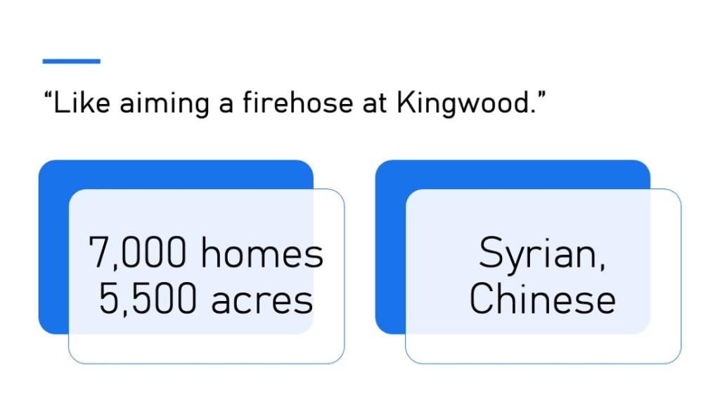
One of the most respected hydrologists in the region has said that if the land gets developed, “it would be like aiming a firehose at Humble and Kingwood.”

At least two state reps have tried to get to the bottom of this with little success.

Nearby neighbors who got wind of the deal and fear flooding from it have been trying since 2025 to understand why the state got involved and what the extent of the state’s involvement is?

Stop Sign at the End of the Information Superhighway

The GLO did not produce the requested records for the neighbors. Instead, GLO asked the Texas Attorney General whether it had to release the records.

This morning, the neighbors received a letter from the AG’s office to Ms. Hadassah Schloss, Director of Open Government at the GLO. The letter to Ms. Schloss by Michelle Garza, Assistant Attorney General in the Open Records Division, says GLO does NOT have to produce the requested records.

So, at this point we don’t know:

  • Whether the deal is on or off
  • How much the state invested
  • If the investment is wise
  • Whether the state can back out without incurring a penalty
  • What options the GLO and developer are considering
  • Why the state contended the land was not in a floodplain even though FEMA Maps clearly show it is
  • Why a state agency charged with flood mitigation is investing in a development likely to make flooding worse.

I’ve never met Ms. Schloss. I’m sure she’s a nice person. But I couldn’t help noticing the irony in her name. In German, “Schloss” means a fortified castle with high walls, often surrounded by a moat to help fend off invading forces. Schloss can also mean “a lock,” as in “locked” doors. And yet, Ms. Schloss is the Director of Open Government for the GLO. But I digress.

Basically, we have government by secrecy.

Bob Rehak

We do know, however, that two executives of Scarborough Lane Development (Ryan Burkhardt and James R. Feagin), the Dallas-based developer behind the deal, made substantial contributions to the re-election campaigns of both Land Commissioner Dawn Buckingham and Governor Greg Abbott.

But hey! The secrecy police did their job.

Posted by Bob Rehak on 3/16/26

3121 Days since Hurricane Harvey

The thoughts expressed in this post represent opinions on matters of public concern and safety. They are protected by the First Amendment of the US Constitution and the Anti-SLAPP Statute of the Great State of Texas.

State Agency Responsible for Flood Mitigation Invests in Flood-Prone Development

12/22/25 – The Texas General Land Office (GLO), which manages state and federal money for flood mitigation, has invested an undisclosed sum of money in a flood-prone development at the confluence of Spring Creek, Cypress Creek and the San Jacinto West Fork. See below.

From FEMA’s Flood Hazard Layer Viewer. Brown = 500-year floodplain, Aqua = 100-year, Cross-hatched = Floodway. Map dated 2014. Floodplains will likely expand 50-100% in updated maps based on Atlas 14.

On the surface, the GLO investment appears to be a conflict of interest. Dig deeper and two separate mandates for the GLO emerge that are not reconciled in state law:

  • To mitigate flooding
  • To help fund public schools.

The GLO home page trumpets how it manages $14.3 billion in disaster recovery and flood mitigation funds.

Simultaneously, the GLO’s website stresses how it manages $60 billion dollars in public school funds. But the investment funds strategic plan makes no mention of flooding. It does, however, say they seek “exceptional returns.” Developments in floodplains can provide those.

I gave multiple people in the GLO Press Office a chance to comment on this post before I published it. Not one replied.

Amount at Stake Could Be as High as $140 Million

A company called Ryko sold the 5,000+ acres in question to Scarborough Houston/San Jacinto Preserve earlier this year.

State Representative Steve Toth claimed in a press release on December 11, 2025, that he was working to revoke the state’s “$140 million investment” in the project by the GLO’s School Land Board.

However, Ryan Burkhardt, the president of Scarborough, told ReduceFlooding that Scarborough itself had close to $140 million invested in the project. He admitted the state was his partner, but refused to say how much the state invested.

Subsequent efforts to verify the GLO involvement in this project revealed that the School Land Board, a group within the GLO, invested in the property. However, the GLO refused to reveal the amount of the investment (and did not say that the investment had been revoked as Toth’s press release claimed).

GLO Statement Admits Involvement, But Sheds Little Light

The terse GLO statement below raises more questions than it answers.

“This investment was approved by the School Land Board (SLB) pursuant to Chapter 51 of the Texas Natural Resources Code (TNRC). The GLO’s investment in this project through the SLB as a limited partner was contingent upon Montgomery County’s approval of the drainage study, which was successfully completed in July 2025. As Land Commissioner, I am committed to preventing future flooding. We are meeting with stakeholders and have heard the local concerns regarding this project. Our agency is dedicated to serving the best interests of the community.” Commissioner Dawn Buckingham, M.D.

Conflicting Mandates

More exploration revealed that the GLO wears two hats. It simultaneously manages flood-mitigation programs and invests School Land Board capital – sometimes in flood-prone land – under conflicting statutory obligations and fiduciary standards.

Those functions report to the same elected official – Dawn Buckingham, M.D. They are:

Flood-Mitigation

Under various statutes and federal requirements, the GLO:

  • Administers U.S. Department of Housing and Urban Development Community Development Block Grant funds for Disaster Relief and Flood Mitigation (HUD CDBG-DR and CDBG-MIT)
  • Manages large-scale flood mitigation and buyout programs
  • Works with local entities such as Harris County Flood Control District, to reduce flooding
  • Evaluates flood risk, vulnerability, and benefit-cost ratios.

In this role, the GLO must:

  • Reduce flood risk
  • Avoid repetitive loss
  • Comply with federal mitigation standards
  • Justify investments of tax dollars based on public safety and resilience.

School Finance

Separately, under the Texas Constitution and Natural Resources Code Chapter 51, the GLO (through the School Land Board) must:

  • Manage land and money as a trust
  • Maximize long-term returns
  • Avoid sacrificing value for unrelated policy goals.

The real conflict here may be competing, internal statutory silos.

Texas law reportedly does not require the GLO’s flood-mitigation knowledge, data, or policy goals to constrain its school-investment decisions.

There seems to be NO:

  • Statutory cross-check
  • Internal requirement preventing such conflict
  • Duty to reconcile flood-risk mitigation goals with land monetization.

The same agency can therefore:

  • Fund buyouts downstream while…
  • Profiting upstream from development pressure that increases downstream risk…

…without violating any explicit statute.

Three Potential Conflicts

From a governance perspective, this arrangement creates at least three tensions:

First, the GLO:

  • Possesses detailed flood-risk data in its mitigation role.
  • But it is not legally required to make investment decisions that consider that data.

Second, the State can:

  1. Invest capital in flood-prone land at a discount
  2. Benefit from development-driven appreciation
  3. Later deploy flood-mitigation grants funded by taxpayers to address resulting impacts.

Third, the conflict creates the appearance of policy incoherence. The State appears to be:

  • Subsidizing flood risk on one side of the balance sheet
  • Funding mitigation on the other.

Why This Remains Legal

According to ChatGPT, this dual role persists because “the Texas Constitution elevates school-fund fiduciary duties to near-absolute status.”

Absent a statute saying, “School fund investments shall be consistent with state flood-mitigation objectives,” the GLO operates in parallel lanes and pursues investments with the highest rates of return.

Sadly, in this case, that includes property in floodplains undervalued upfront because of flood risk.

Where This Leaves the Scarborough/San Jacinto Preserve Issue

The school-fund investment side of the GLO may not even understand the flood risk or recognize the political sensitivity. It likely focuses only on evaluating the land primarily as an undervalued trust asset.

This case makes a powerful example of conflicts of interest. However, I have another concern: transparency. Two state legislators and multiple residents have requested information about the state’s involvement with little luck.

Both Toth and State Representative Charles Cunningham have reached out to the GLO on behalf of downstream constituents. But so far, neither legislator has received an explanation.

Even worse, residents’ FOIA requests (going back to October) have been denied and appealed to the State Attorney General’s office, which denied them also. Three months of inquiry have resulted only in the one terse statement printed above.

This is an absolute PR disaster fraught with multiple potential conflicts of interest. The GLO is creating the appearance of a coverup even if none exists.

Bob Rehak

Need for Full Disclosure Now

The State and GLO should insist on full disclosure now. That includes any political contributions made by the land owners or sellers (directly, or indirectly through family members, employees or PACs) to state officials, especially those connected to the School Land Board.

According to the Texas Water Development Board’s most recent state flood plan, the number of Texans living in floodplains exceeds the population of 30 states. This investment illustrates one of the reasons.

We also need to verify whether the developer really received approval of its drainage impact analysis in July of 2025, as claimed in the GLO statement above. The so-called “approval” letter I have from the Montgomery County engineer dated July 2025 (when Ryko still owned the land) is best characterized as preliminary. It says, “Here are three pages of issues you need to address to get approval.” It does NOT give full, final approval.

One issue MoCo raises is adequate emergency access during 500-year, Atlas-14 flood events. But a Townsend Blvd. extension across Spring Creek was taken off Montgomery County’s 2025 road bond to help deter development of Scarborough’s property.

At this point, Montgomery County Precinct 3 Commissioner Ritch Wheeler, Harris County, State Representative Steve Toth, and City of Houston have all come out against this project because of the flood risk. But I have seen no official announcements from the Governor’s Office or the GLO about cancelling their support.

In my opinion, the only good investment in this land would be to turn it into a state park.

To continue backing this Scarborough deal may make better financial sense than public policy. As one public official told me, “Typical government…trying to fix problems it creates!”

Posted by Bob Rehak on 12/22/25

3037 Days since Hurricane Harvey

The thoughts expressed in this post represent opinions on matters of public concern and safety. They are protected by the First Amendment of the US Constitution and the Anti-SLAPP Statute of the Great State of Texas.

The Profit in Floodplain Development Explained

12/19/25 – Despite substantial hurdles, floodplain development can be very profitable for patient developers with deep pockets, even if only a small percentage of their land is developed.

For instance, Scarborough Lane Development/San Jacinto Preserve LP has purchased more than 5,000 acres of land in floodplains and floodways near the confluence of four waterways. They include the San Jacinto West Fork, Spring Creek, Cypress Creek, and Turkey Creek.

Floodplains Streams from Ryko Drainage Study
Base map from seller’s preliminary drainage analysis. Scarborough/San Jacinto Preserve property outlined in red. Shades of blue represent floodways and floodplains on property.

Buyer Says It Paid $140 Million for Property Appraised at Less Than $1 Million

Scarborough claims it paid close to $140 million for the property – 8X higher than the Montgomery County Appraisal District (MCAD) places the market value of the land and 175X higher than the appraised value. See below.

This image has an empty alt attribute; its file name is Scarborough-Appraised-Value-1024x518.png
Source: MCAD-TX.org. Timber exemptions account for low appraised value. Size = acres

Even more stunning, Ryko, the company that sold the property to Scarborough/SJP, produced a preliminary engineering study that suggested only 38% of the land was developable because it has such high flood risk.

So, in what galaxy does this make economic sense?

Actually, it makes perfect sense – if you understand how the game is played.

Spread Makes Bread

Said another way, buy low; sell high.

The exceedingly low appraised value of floodplain land helps developers acquire and hold the land, sometimes for decades – at a very low tax cost while they work out regulatory issues. And when they do, the step change in value is so great, that if only 20% of the land is developable, they likely still make money.

This is according to ChatGPT, which costed out details of several development scenarios for me. One was even profitable with only 10% developable land.

A wide spread between acquisition costs and potential land sales after all permits and mitigation costs are accounted for is one of the main reasons why developers target floodplain land.

The dynamic is well understood in land economics and is particularly visible in fast-growing regions like Montgomery County.

Floodplain land often sells at a steep discount relative to nearby uplands because of:

  • Regulatory limits (floodway vs. floodplain)
  • Engineering costs (fill, detention, bridges)
  • Uncertainty (permitting, litigation, political risk)
  • Time value (increased holding costs because of longer periods before land becomes salable).

With steep, discounted prices in mind, even modest success—e.g., making 20–30% of a tract buildable — can make the entire investment profitable. Anything above that is gravy.

Why Floodplain Land Produces Unusually Large Spreads

Floodplain land tends to be priced as “mostly unusable.” Once permits are secured, the buildable portion prices like normal land. But the remainder can still be monetized as detention, mitigation, or open space.

Better yet for the developer, some of the land designated as green space may even be developed years later as the pain of flooding dims and political winds shift.

This can create huge “step” changes in land value.

Factors that Amplify Spread

In Texas, several factors amplify this spread. Consider, for instance:

Timber Exemptions that Lower Carrying Costs:

Developers pay only a few dollars in taxes per acre per year. On the five parcels above, taxes average $148 per acre per year. That makes patience very cheap. A well capitalized developer can afford to wait years while working out permitting issues.

Timber exemptions also mask speculative intent. On paper, the land looks like a passive forestry holding, not a development play.

Reliance on Post-Development Mitigation at Public Expense:

Some developers shift part of their mitigation costs onto the public. For example, some developers in Montgomery County have avoided building detention basins by using questionable flood routing studies. Even the former Montgomery County engineer criticized the practice. As flood peaks build over time, downstream residents clamor for mitigation. But it comes at public expense. So the developer has effectively externalized some of its costs.

Permissive Local Drainage Rules and Lax Enforcement:

This is especially true in counties that surround fast growing metropolitan areas. Some counties around Houston still use drainage criteria from the 1980s to help attract development.

Sometimes gaps in regulations cause flooding as Elm Grove discovered twice in 2019. Many floodplain developers tend to exploit such gaps in regulations and then claim they are complying with all applicable regulations.

Montgomery County recently upgraded its drainage criteria manual and adopted Atlas 14 rainfall probability standards. But willful blindness among regulators can still create a permissive environment to the detriment of people living downstream.

Risk/Reward Ratio Attracts Only Certain Types of Developers

Floodplain land tends to attract well-capitalized, patient developers with a 10–20 year horizon. For those with deep pockets and powerful partners, economics may work even if 90% of the land never becomes buildable.

This is not accidental; it is a rational, well-understood land-banking strategy.

However, the spread only turns into profit if risk converts to permission. It collapses if floodway limits are strictly enforced, mitigation costs surge, public opposition blocks approvals, or political sentiment hardens after major floods.

In such cases, floodplain land can become a capital trap, not a bargain. But still…

The large spread between low purchase cost and high potential value is a major magnet for developers.

And that’s how the Houston region got 65,000 homes built in floodplains since Hurricane Harvey, as investigative reporter Yilun Cheng discovered for the Houston Chronicle.

Courageous reporting, such as hers, makes flood risk highly visible and politically salient. And that makes the spread harder to monetize. Witness recent resolutions by Harris County Precinct 3 and the City of Houston. It will be interesting to see Scarborough’s next moves.

Next Up

I am working on a series of posts about floodplain development. Next, I’ll examine the seductive promise of green space. Floodplain developers often promote abundant, recreational green space to early buyers in a development.

But just as often, they try to monetize that green space during the latter stages of a development – green space they promised early buyers would remain green forever. Check out the warning-sign checklists in my next post before you buy property to see if your green space could someday vanish.

Scarborough property near US59 bridge west of Kingwood. San Jacinto West Fork on right. During Harvey, water was 27 feet above the level you see here.

Posted by Bob Rehak on 12/19/2025

3034 Days since Hurricane Harvey

The thoughts expressed in this post represent opinions on matters of public concern and safety. They are protected by the First Amendment of the US Constitution and the Anti-SLAPP Statute of the Great State of Texas.

City Council to Vote on Development in Area with Catastrophic Flooding

12/14/25 – The Houston City Council will vote Wednesday, December 17 on a resolution opposing the proposed 5,300 acre Scarborough Lane/San Jacinto Preserve Development in Montgomery County. Virtually the entire area lies in floodplains and floodways west of Kingwood near the confluence of the San Jacinto West Fork, Spring Creek, and Cypress Creek.

The resolution says that the area is “repeatedly marked by catastrophic flooding, rendering the tract unmistakably unfit for residential development.”

The City resolution comes less than a week after Harris County unanimously adopted a similar resolution

Resolution Highlights Potential Liability to Developer

The resolution, proposed by District E Council Member Fred Flickinger, also warns the developer about “potential liability associated with placing future residents in an area of heightened risk for property damage, personal injury, and loss of life.”

While the proposed development lies wholly within Montgomery County, it also lies wholly within Houston’s city limits and extra-territorial jurisdiction.

The resolution largely parallels a similar motion adopted unanimously on 12/11/2025 by Harris County Commissioners Court.

Other Key Provisions of Resolution

Among other things, the resolution urges Montgomery County to:

  • Apply Harris County drainage standards when evaluating the developer’s plans
  • Evaluate the property for flood-mitigation, flood-preservation, and public park purposes
  • Implement flood-mitigation protections while restoring wetlands, replenishing groundwater, and safeguarding the future of surrounding communities.

See the complete text below or download the PDF here.

Text of Resolution


City of Houston, Texas, Resolution No. 2025-              

A RESOLUTION OF HOUSTON CITY COUNCIL OPPOSING THE PROPOSED SCARBOROUGH LANE DEVELOPMENT IN MONTGOMERY COUNTY, LOCATED IN THE EXTRATERRITORIAL JURISDICTION OF THE CITY OF HOUSTON, TEXAS AND A PORTION IN AN AREA ANNEXED BY THE CITY OF HOUSTON, TEXAS FOR LIMITED PURPOSES; CONTAINING VARIOUS FINDINGS AND OTHER PROVISIONS RELATING TO THE FOREGOING SUBJECT.

*  *  *  *  *

WHEREAS, The City of Houston and Harris County lead the nation in flood-prevention investments, with more than $3.5 billion committed to flood-mitigation projects over the coming years, and urges Montgomery County leadership to adopt, at minimum, the drainage criteria previously approved by the Harris County Commissioners Court; and

WHEREAS, the land proposed for the Scarborough Lane Project in Montgomery County rests at the vulnerable confluence of Spring Creek, Cypress Creek, and the West Fork of the San Jacinto River, an area repeatedly marked by catastrophic flooding, rendering the tract unmistakably unfit for residential development; and

WHEREAS, any further construction within this well-documented flood zone would inevitably heighten flood dangers, placing the residents of Montgomery and Harris Counties at greater risk and compounding the devastation they have already endured; and

WHEREAS, this resolution serves as notice to the developer regarding potential liability associated with placing future residents in an area of heightened risk for property damage, personal injury, and loss of life; and

WHEREAS, the highest and best use of this property should be evaluated for flood-mitigation, flood-preservation, and public park purposes; and

WHEREAS, any development of this parcel must rigorously meet or exceed Harris County standards, including the elevation of finished floors, and any proposed mitigation ponds must be located entirely outside the current 100-year floodplain and completely beyond the floodway, ensuring no increased risk to surrounding communities; and

WHEREAS, all mitigation efforts should prioritize detaining stormwater as early as possible during rainfall events; and

WHEREAS, this tract stands as a rare and extraordinary opportunity to transform a hazardous flood zone into a steadfast shield against disaster, delivering vital flood-mitigation protections while restoring wetlands, replenishing groundwater, and safeguarding the future of surrounding communities;

NOW, THERFORE, BE IT RESOLVED BY THE CITY COUNCIL OF THE CITY OF HOUSTON, TEXAS:

Section 1. That the findings contained in the preamble of this Resolution are determined to be true and correct and are hereby adopted as part of this Resolution.

Section 2. That the City Council respectfully calls upon the leadership of Montgomery County to reconsider the currently proposed Scarborough Lane development and any future development on this property, as it poses unacceptable hazards to future residents of Montgomery County and will substantially increase flood risks for existing residents of both Montgomery and Harris Counties.

Section 3. That this Resolution shall take effect immediately upon its passage and approval by the Mayor; however, in the event that the Mayor fails to sign this Resolution within five days after its passage and adoption, it shall take effect in accordance with Article VI, Section 6, Houston City Charter.

[Signatures]


HCFCD/MoCo Both Tried to Buy Property for Flood Mitigation

Harris County Flood Control District tried to buy the property after passage of the 2018 flood bond. But reportedly, the property owner at the time wanted much more than the appraised value of the property.

A person familiar with the negotiations at the time told me that, “If that property ever gets developed, it would be like aiming a fire hose at Kingwood and Humble.

Ryko, the owner at the time, planned to build 7000 new homes on the property according to Montgomery County Precinct 3 Commissioner Ritch Wheeler. Wheeler also tried to buy the property. But the developer reportedly wanted north of $100 million for it.

A press release by Wheeler, dated 12/11/25, states that he believes “preserving this land for public use and for future generations remains a shared goal across our community.”

“If successful,” Wheeler said, “the effort would allow the land to be protected for regional detention, parks, trails, and natural green spaces, ensuring it remains an environmental and recreational asset for Montgomery County residents.”

Floodplains Streams from Ryko Drainage Study
Base map from seller’s preliminary drainage analysis. Scarborough/San Jacinto Preserve property outlined in red.

For More Background Information

See these previous posts about Ryko, Scarborough and the San Jacinto Preserve.

12/13/25 Harris County Passes Ramsey Resolution on Scarborough Development In MoCo

10/31/25 Supposed “Letter of No Objection” to Floodplain Development Lists 3 Pages of Objections

10/30/25 New Plans to Develop 5,316 Acres West of Kingwood Mostly in Floodplains, Floodways

10/16/25 Developer Buys 5300 Acres of Floodplains, Floodways, Wetlands from Ryko

5/7/25 Is It Safe to Build 7,000 Homes on Ryko Land?

5/6/25 Montgomery County Engineering Letter Blasts Ryko’s Drainage Study

4/25/25 Lengthy Catalog of Concerns about Proposed Ryko Development

4/23/25 Harris County Did NOT Approve Ryko Development

4/18/25 Bald Eagles Live Where Developer Wants to Build 7,000 Homes

4/17/25 MoCo Commissioner Taking Townsen Blvd. Extension Off 2025 Road Bond

Posted by Bob Rehak on 12/14/25

3029 Days since Hurricane Harvey

The thoughts expressed in this post represent opinions on matters of public concern and safety. They are protected by the First Amendment of the US Constitution and the Anti-SLAPP Statute of the Great State of Texas.

Supposed “Letter of No Objection” to Floodplain Development Lists 3 Pages of Objections

10/31/25 – On 10/29/25, Scarborough Development/San Jacinto Preserve pitched their plans to develop 5,372 acres in Montgomery County and build a bridge across Spring Creek to Harris County.

They told Precinct 3 Commissioner Tom Ramsey and Houston City Council Member Fred Flickinger that they had “letters of no objection” (LONOs) from the Montgomery County Engineer and Harris County Flood Control District. See the red box on the page below.

LONO stands for Letter of No Objection.

The phrasing of the text implies “approval.” However, reading the text of the actual letters suggests that huge concerns remain about the project.

Montgomery County Concerns

The letter from Brian Clark, Montgomery County engineer, dated 7/2/25 or one month before Ryko sold the land to Scarborough Development/San Jacinto Preserve, has no objection to the preliminary information provided but goes on to list three pages of concerns. They start with an underlined phrase in the second paragraph.

“…additional analysis will be required incorporating a definitive land plan.”

Brian Clark, PE, Montgomery County Engineer

Clark goes on to say that the land plan must be approved before any construction for any portion of the development can be approved. In addition, he says that additional analysis and construction plans must address Montgomery County’s following concerns:

  • Significant potential for erosion under homes, roads, utilities and bridge(s)
  • Need for emergency access and rescue planning during floods
  • Potential for increased floodplain levels due to future upstream development, which could place the entire project in the 100-year floodplain. “This creates a high risk of future flood blight, negatively impacting the tax base and endangering future residents,” he said.

Page 2 contains a lengthy list of information still required:

  • Detailed drainage master plan including specific lot, street, and detention pond sizing and locations.
  • Master plan that includes a comprehensive, no-rise, floodplain analysis for the 5-, 10-, 100- and 500-year Atlas 14 peak flows, along with drawings that show proposed grading and the extent of floodplain encroachment.
  • Atlas-14, 500-year water elevations in all models
  • Adequate mitigation for any fill in the 100-year floodplain
  • Develop and implement robust erosion control measures and geotechnical studies to ensure the long-term stability of the development
  • Design bridge and road network to guarantee adequate emergency access during the Atlas-14, 500-year storm
  • Analyze the proposed bridge location and describe how the proposed bridge will accommodate the dynamic (shifting) nature of Spring Creek
  • Emergency access plans must be approved by the county before any plans for sections in the subdivision will be reviewed
  • Submit documents indicating Army Corps approval, including any mitigation the Corps requires
  • Complete environmental due diligence documentation pertaining to Endangered Species Act
  • Approval of bridge plans by Harris County Flood Control District showing no modification to the main stem of Spring Creek will be required before MoCo provides any future letters of no objection.

Pages 2 and 3 contain cautions about:

  • Data and calculations made in the preliminary drainage analysis
  • A conditional letter of map revision (CLOMR) must be approved by FEMA before the county can approve bridge construction plans
  • The limited nature of the LONO itself.

The letter closes with a warning:

“This memorandum does not guarantee that the ‘developable areas’ presented in the report will remain unchanged as more information becomes available.”

Brian Clark, PE, Montgomery County Engineer

That sounds like quite a mountain to climb! Especially since MoCo Precinct 3 Commissioner Rich Wheeler took the Townsen Blvd. Extension off the County’s 2025 Road Bond. Harris County Precinct 3 Commissioner Tom Ramsey, PE, also vehemently opposes a bridge across Spring Creek. And the area upstream from this development is one of the fastest growing in the region…and the country, according to the Census Bureau.

Text of Letters

Here is the entire letter, obtained via a FOIA request.

And here is the entire letter from HCFCD. It expresses many of the same concerns.

Photos Make A More Compelling Case than Engineering Studies

Having spent years now studying how upstream development changes downstream assumptions about flooding, I hope this area does not get developed. Significant public safety concerns exist.

We should never forget what happened to Kingwood and Humble, and the I-69 and UnionPacific Railroad Bridges during Harvey.

Even if Scarborough/San Jacinto Preserve could build a bridge across Spring Creek, it would not form a reliable evacuation route in the event of another Harvey. Why? People coming south could be in floodwaters over their heads once they got off the bridge. See the pictures below.

US59 at West Fork during Harvey
Another view of Harvey at I-69. The Spring Creek bridge would come down in the flood, out of frame to the right. Water at this location reached 22 feet above flood stage.
west fork flood during Harvey
Townsen Road in Humble (center) where it crosses I-69. Photo courtesy of Harris County Flood Control District.
I-69 during Harvey. Photo by Melinda Ray. So much for evacuation routes to the south.
I-69 repairs
It took TXDoT almost a year to repair the I-69 bridge causing massive traffic jams on alternate routes.
UP Rail Bridge Wash Out
Harvey also destroyed the UnionPacific railroad bridge over the West Fork.

Even the I-45 and West Lake Houston Parkway bridges were damaged.

So, in my opinion, there is NO reliable evacuation route to the south. Period. End of story.

For more photos from Harvey, see Dawn of a Disaster.

The developer can save his money on the engineering studies and cut his losses. The only way to salvage anything from this disaster-in-the-making is to donate the land to Texas Parks and Wildlife, take a tax deduction, and trumpet your concern for the environment.

Posted by Bob Rehak on 10/31/25

2985 Days since Hurricane Harvey

The thoughts expressed in this post represent opinions on matters of public concern and safety. They are protected by the First Amendment of the US Constitution and the Anti-SLAPP Statute of the Great State of Texas.

Developer Buys 5300 Acres of Floodplains, Floodways, Wetlands from Ryko

Update 10/16/25 at 10am – The Planning Department intends to recommend deferring consideration of the general plan discussed below until after the City of Houston District E and Harris County Precinct 3 have have met with the new owner.

10/15/2025 – San Jacinto Preserve and a sister company, Scarborough Houston LLC have purchased approximately 5300 acres of land west of Kingwood from Ryko Development and its sister company, Pacific Indio Properties.

Ryko tried for years to develop the property, most of which is floodplains, floodways and wetlands where the San Jacinto West Fork, Spring Creek, Turkey Creek and Cypress Creek all converge.

Concerns about flooding may have triggered Ryko’s sale after a succession of rapid-fire setbacks:

  • May 2024 floods and the second largest release from Lake Conroe in the history of the SJRA rekindled memories of Harvey’s devastation.
  • A Townsen Blvd. extension through the property was taken off Montgomery County’s 2025 Road Bond at the request of neighboring residents and MoCo Precinct 3 commissioner Ritch Wheeler.
  • The Montgomery County Engineer blasted Ryko’s drainage study
  • Harris County Flood Control did not approve Ryko’s flood-mitigation plans.
  • Harris County Precinct 3 Commissioner Ramsey lined up against a bridge that would connect the area to Humble.

Sale of Property to San Jacinto Preserve, LP, Scarborough Houston LLC

Under public pressure on all sides and faced with the loss of connectivity and critical infrastructure support, Pacific Indio sold the property to San Jacinto Preserve, LP and Scarborough Houston LLC in August of this year. Here is the Special Warranty Deed.

Both buyers have common ownership and management, as with Ryko and Pacific Indio. Companies often try to limit liability by setting up different companies for different projects. That way, if one part of the empire encounters trouble, it won’t bring down other parts.

In this case, the names of two men keep showing up: Ryan Burkhardt and James R. Feagin. Among the many companies under their control:

Scarborough Lane Development appears to be at the top of the food chain and headquarters in Addison, TX, a north Dallas suburb. All the other companies list the same address. So even though company names change, the same people control everything.

Scarborough Lane Development’s website says its “always committed to protecting the environment.” And it brags that it is “capable of handling the most challenging development projects.” We shall see.

Land Virtually Covered by Floodplains, Floodways

This project will test their talent as this map in Ryko’s drainage analysis shows. Only the small, dark gray areas in the red outline are above the 500-year floodplain.

Ryko drainage impact study illustration showing outline and floodplains.
Ryko’s drainage impact analysis showed this map of floodplains, floodways and streams on their property (outlined in red).

But keep in mind, that the floodplains will soon expand when FEMA releases new maps based on data acquired after Hurricane Harvey. The floodplain mapping above is from 2014. It predates the Memorial Day Flood, Tax Day Flood, Harvey, and the May 2024 flood.

On Houston Planning Commission Agenda for 10/16/25

San Jacinto Preserve’s (SJP) general plan is on the Houston Planning Commission’s consent agenda for Thursday, 10/16/25. See below. Their engineers chose to render the floodplains in barely distinguishable shades of gray this time.

Lisa Clark, who Chairs the Houston Planning Commission, also represents the San Jacinto Preserve.

Both Harris County Precinct 3 and City of Houston District E have requested the planning commission to postpone consideration until they have had the opportunity to meet with the developer and learn more about the plans.

Here is the General Plan that SJP submitted to the Planning Commission.

For a full-size, high-resolution PDF, click here.

This is a pretty high-level plan. It shows planned major thoroughfares, easements, pipelines, property boundaries, drill sites, and floodplains/floodways. But it’s not yet a plat that shows the street layouts of neighborhoods or homesites.

However, it does still show a Townsen Blvd. extension bridging across Spring Creek into Humble. That piqued my interest.

I called Mr. Burkhardt in Addison for clarification, but he did not return my phone call to confirm exactly what their plans are. So we shall have to wait and see. They will have challenges, no doubt.

MoCo Residents Successfully Protest Connectivity Plan

Yesterday, Benders Landing Estates (BLE) Property Owners Association (immediately north of the SJP property had a proposal on the Montgomery County Commissioners Court Agenda. SJP wanted to connect their new neighborhoods through a quiet, residential street (Shady Hills Landing Lane) in BLE.

They felt the street was not suited to handling the volume of traffic that a 5000+ acre development would generate. And their plan to block SJP access through the street succeeded.

Commissioners voted to abandon a one-foot-wide portion of Shady Hills Landing Lane in Benders Landing Estates Section 7. The land will vest to adjoining property owners, who can then effectively block SJP residents from exiting any new subdivisions through their property.

Commissioners Court unanimously approved the measure. It was a minor victory and likely will not affect the long-term war. But it showed the will of the community.

Profits Over People?

The San Jacinto Preserve development comes with inherent flood risks. At this point, we need to wait and see what they propose. At a minimum, it will likely include:

  • A new drainage-impact analysis
  • New plats that show the exact location of homes and their density relative to floodplains
  • Street layouts
  • The amount of impervious cover added
  • How much forest is lost
  • Flood-mitigation plans
  • A no-adverse-impact statement from Texas-certified engineers.
  • Environmental/wetlands studies including impacts on water quality in Lake Houston
Wetlands in SJP floodplain

One seasoned hydrologist held out little hope for the safe development of this property. She told me that developing it would be like aiming a firehose at Kingwood. She also suggested that the developer was putting “profits over people” and that the people of Humble and Kingwood should oppose it for their own safety. Check back often as news develops.

Posted by Bob Rehak on 10/15/25

2969 Days since Harvey

The thoughts expressed in this post represent opinions on matters of public concern and safety. They are protected by the First Amendment of the US Constitution and the Anti-SLAPP Statute of the Great State of Texas.

Is Downstream Flood Mitigation Keeping Pace with Upstream Development?

5/14/25 – This morning, I gave a presentation that compared the pace of downstream flood mitigation with the pace of upstream development. Are we gaining or losing ground in the Lake Houston Area?

Presentation Connects Many Dots

Answering that question requires connecting many dots. Here are the slides from the presentation with my narrative.

To download a PDF of the presentation, click here.
Offsetting Forces

As new upstream development adds impervious cover (roads and roofs) that can increase and accelerate runoff, building flood peaks higher and faster. And that can erode the safety of downstream residents. Managing flood risk becomes a struggle between competing forces.

MoCo One of Fastest Growing Counties in Country

The Lake Houston Area lies downstream from one of the fastest growing counties in the country. Montgomery County (MoCo) grew 68% in the last 15 years and 4.8% in 12 months recently. MoCo is currently the seventh fastest growing county in the entire country.

Ryko Exemplifies Danger of Upstream Development

Let’s look at a proposed MoCo development in the headwaters of Lake Houston. A company named Ryko bought 5,500 acres about a quarter mile west of Kingwood. It’s in the southern part of a triangle formed by Spring Creek, the San Jacinto West Fork and the Grand Parkway.

US59 Bridge in foreground by the confluence of the Sand Jacinto West Fork and Spring Creek.
“Like Aiming a Firehose At Kingwood”

Ryko, which is a Syrian-owned company, is reportedly working with Wan Bridge, a Chinese company, to develop 7,000 homes on the property. One of the leading hydrologists in the area told me that developing this property would be “like aiming a firehose at Kingwood.”

Many “Guardrails” Being Removed

Government has established many guardrails over time to protect people from insufficiently mitigated upstream development. But many of the guardrails are being removed. Or people are trying to remove them.

In this case:

  • A change to the state property code in 2023 gave developers the right to opt out of a city’s extra territorial jurisdiction (ETJ). ETJs lay the groundwork for future annexation by ensuring new infrastructure meets the standards of areas that might annex them someday. But if developments are not in an ETJ, they could change plats without approval.
  • Two bills pending in the legislature, HB23 and its companion SB2354, would essentially let developers “self-permit” by hiring engineering firms that replace government oversight.
  • The Endangered Species Act (ESA) constrains development in areas inhabited by threatened or endangered species. But Executive Order 14192 could change that. The US Fish and Wildlife Service has proposed a change under the order that means Ryko would no longer have to work around endangered species on its property.
  • An ex-Senior VP of Ryko for 21 years is now chair of the Houston Planning Commission. She still reportedly represents the company as an independent consultant,
  • The Montgomery County Drainage Criteria Manual hasn’t had a serious update for 40 years. The County still allows controversial practices, such as hydrologic timing surveys, to “prove” that upstream developments have no adverse impact on downstream residents.

Let’s take a closer look at the Ryko property with these issues in mind.

Upstream Development Almost Entirely in Floodplains

With that as a backdrop, what’s going on with the Ryko land? The map in the background for this next slide comes from Ryko’s Drainage Impact Analysis. It shows that their property (outlined in red) lies at the confluence of four major streams. All that blue represents floodplains and floodways.

Property outline and stream names enhanced for readability.
How Bad Is Ryko’s Flood Risk?

FEMA’s base-flood-elevation viewer shows that at the southern end of Ryko’s property, any homes would be under 25 feet of water in a 500-year flood (18.7 feet in a 100-year flood). Even at the higher elevations farther north, homes would be under 7 feet of water in a major flood.

Frequent Bald Eagle Sightings

Homeowners father north report frequent sightings of bald eagles. They believe the eagles live on Ryko’s property which is currently wilderness. One resident sent me a video of two eagles that landed in a tree right outside her living room window.

Click here for video.
How Developers Document “No Adverse Impact”

The Texas Water Code contains a rule that states upstream development can have “No Adverse Impact” on downstream neighbors. To prove no adverse impact, engineers compare estimated pre- and post-development runoff.

If post-development estimates are less than or equal to pre-development, they satisfy the requirement.

Estimates Based on Hydrologic Timing Not Always Accurate

But how accurate are those estimates? Montgomery County’s antiquated drainage criteria manual still lets engineers use hydrologic timing surveys, a practice now prohibited by the City of Houston and Harris County for several reasons.

Timing studies let developers avoid building detention basins if they can show that their development’s stormwater “beats the peak” of a flood. The theory: they aren’t adding to the peak.

Not building detention basins saves developers money and adds to the number of salable lots. But “beat the peak” studies have serious limitations and can often mislead.

They assume, for instance, a uniform storm across an entire watershed. But that rarely happens. Imagine the case of a storm like Harvey, which approaches from the south as developers to the north rush to get their water to the river. God help the people caught in the middle.

Timing surveys, in the case of Montgomery County, are also based on decades old data that ignores the cumulative impacts of other developments over time.

How Avoiding Detention Can Add to Flood Peaks

What often happens in reality is that you get higher peaks than if you had built detention. This graph shows three lines. The two at the bottom show typical pre- and post-development runoff rates where/when hydrologic timing studies are prohibited.

Not building detention often leads to earlier, higher peaks.

The height difference could be the difference between flooding or not flooding.

MoCo Still Doesn’t Require More Reliable Method

In short, building stormwater detention is a sure thing. Hydrologic timing is not.

Banning hydrologic timing studies would force developers to design systems that TRULY detain and slow runoff. But Montgomery County still permits timing studies. The County’s new Drainage Criteria Manual that prohibits them has been sitting on the shelf for more than a year.

Downstream Mitigation Slowing

Now, let’s look at what downstream residents are doing to offset the impacts of upstream development.

Compared to the period after Harvey, that activity has slowed. The Lake Houston Area Task Force identified three crucial needs to reduce flood risk.

  • Dredging to increase throughput
  • More floodgates on Lake Houston to speed up output
  • Upstream detention to reduce input.
Dredging is Highlight to Date…

Dredging continues. We’ve spent approximately $200 million to date and that total is still increasing.

Images shot current West Fork dredging plan, location of dredge by FM1960, and spoils placement area by Luce Bayou.
…But More Sediment Keeps Coming

After the Army Corps finished its emergency West Fork Dredging Project, they recommended regular maintenance dredging to ensure our rivers had sufficient conveyance and our drainage ditches were not blocked. State Representative Charles Cunningham authored HB1532 to create a dredging district for the Lake Houston Area.

HB1532 passed overwhelmingly in the House and is now waiting to be heard by Senator Paul Bettencourt’s Local Government committee in the Senate.

But this legislative session ends in two weeks. Any bill not out of committee by this Friday is effectively dead. And Bettencourt has not yet scheduled Cunningham’s bill for a hearing.

Construction on More Floodgates Not Likely Before 2027

The additional floodgates on Lake Houston have been delayed repeatedly for various reasons. Simultaneously, the Coastal Water Authority (CWA) is looking at the costs of repairing the dam and replacing it altogether. The 70+ year old dam is near the end of its useful life.

CWA board member Dan Huberty stated that engineering for additional gates should be complete by 2027. At that time, the project will go out for bids.

The CWA won’t receive preliminary reports on dam repairs and replacement until at least July of this year.

No Progress on Upstream Detention, None Likely Anytime Soon

Meanwhile, virtually nothing has happened yet in terms of upstream detention. The San Jacinto River Authority identified 16 areas for upstream detention basins/lakes in its River Basin Master Drainage Study.

SJRA has no construction funds. So many of the projects were incorporated into the state flood plan. But the state’s Flood Infrastructure Fund does not have a committed revenue stream.

The Texas Water Development Board has about a billion dollars currently available to build $54 billion worth of requests in the flood plan.

So keep the pressure on elected representatives who can protect your family.

Posted by Bob Rehak on 5/14/25

2815 Days since Hurricane Harvey

Is It Safe to Build 7,000 Homes on Ryko Land?

5/7/25 – A developer named Ryko has announced plans to build 7000 homes on floodplain land that could be inundated with 7 to 25 feet of floodwater in the next 0.2% annual chance storm. The Houston area has had four such storms in the last 10 years.

From a public policy perspective, that raises three questions:

  • Could homeowners on Ryko land survive a major flood?
  • Would evacuating them put first responders at risk?
  • Is there a better use for the land?

Developer’s Entire Property Likely Under Water During Harvey

Benders Landing Estates (BLE) is currently the southern extent of development in the triangle bounded by Spring Creek, the San Jacinto West Fork and the Grand Parkway. Several of the southernmost homes in BLE flooded during Harvey.

From there, the Ryko land drops 30 feet in elevation to the confluence of Spring Creek and the West Fork. So, it stands to reason that virtually everything on Ryko’s land flooded, too.

FEMA’s Base Flood Elevation Viewer shows that in a 500-year flood, land at the southern end of Ryko’s property near the confluence of Spring Creek and the West Fork would be under 25 feet of water. And at the northern end, higher land would be under 7 feet.

Flood height above land near confluence of Spring Creek and West Fork. From FEMA Base Flood Elevation Viewer.

Would Such Flooding Be Survivable?

At the deeper end of Ryko’s property, such a flood might not be survivable. Look at what that much water did to the townhomes in Forest Cove a little more than a mile downstream from Ryko.

Forest Cove Townhomes
Townhomes cut in half by Harvey’s floodwaters. Photo: September 14, 2017.

Close up, the damage looked like this.

Riverview townhome
Forest Cove Townhome destroyed by Harvey.

Of course, damage at the higher elevations on Ryko’s land would not be as severe. Whether Ryko’s residents could survive would depend on how deep in the floodplain they lived and whether they could evacuate before floodwaters rose.

One resident of Benders Landing Estates told me of helicopter rescues during Harvey.

Comments on this social media post during Harvey went on for five pages.

If BLE residents had to be rescued by helicopter, imagine the logistics of rescuing thousands more deeper in the floodplain.

Assuming an average population density of about 2.5 people per household, Ryko’s 7,000 homes could hold 17,500 people.

Rescuing that many residents by helicopter would be an air traffic control nightmare…especially in heavy weather with limited visibility.

Putting First Responders at Risk

Harvey’s floodwaters rose at night as people were sleeping…without warning or time to evacuate. A few miles downstream, a dozen people died as a result of injuries sustained during evacuation by boat. A first responder told me that HFD estimated the West Fork water speed at 22 MPH. That’s dangerous!

Clearly, there are no good ways to rescue that many people when floodwaters rise that high next time.

Is There a Better Use for the Land?

Yes. This land would make an ideal park. And we already have an ideal model in the nearby Lake Houston Wilderness Park. Both areas:

  • Are roughly similar in size.
  • Lie between major streams
  • Are unsafe to develop.
  • Flood regularly.
  • Host a variety of wildlife including bald eagles.
The natural solution to flooding: park land.

If wilderness floods, it won’t endanger people or property. When water recedes, life goes back to normal without:

  • Presidential disaster declarations
  • Congressional appropriations
  • Bankrupting the national flood insurance program
  • Decades of flood-mitigation grants and rebuilding efforts.

To end on a positive note, parks enhance home values for humans. Multiple studies have shown that proximity to parks enhances the value of homes.

Perhaps it’s time for Ryko to recognize that developing this land is too risky. Doing so would open themselves up to multi-million dollar lawsuits if people died in a flood…especially after they were warned by Montgomery County that developing the land was unsafe.

In my opinion, Ryko should put a reasonable price on the property that lets the State, County and/or City turn the land into a park. Then everyone could win and walk away whole.

Posted by Bob Rehak on 5/7/25

2808 Days since Hurricane Harvey

The thoughts expressed in this post represent opinions on matters of public concern and safety. They are protected by the First Amendment of the US Constitution and the Anti-SLAPP Statute of the Great State of Texas.

Montgomery County Engineering Letter Blasts Ryko’s Drainage Study

5/6/25 – ReduceFlooding has obtained an uncharacteristically blunt letter via a Freedom of Information Act request to Montgomery County’s Engineering Department. The letter blasts Ryko’s Drainage Study for its proposed 5,500-acre development deep in the floodplains near the confluence of four major streams across US59 from Kingwood.

Base map from Ryko Drainage Study. Emphasis added to property boundary (red) and stream names for readability. Shades of blue show floodways and floodplains.

Overview of Drainage Study Objections

The letter, which brims with frustration, strongly objects to Ryko’s Preliminary Drainage Impact Study based on safety concerns. It then lectures Ryko’s engineers about their responsibility to protect the public and goes on to address seven specific concerns.

The author of the letter has since left the Montgomery County Engineering Department after James Noack, who was Montgomery County Precinct 3 Commissioner at the time, reportedly objected to the letter’s objections.

Letter Later Rescinded

A month later, Montgomery County’s Director of Engineering Services sent a second letter to Ryko’s engineers. The terse, three-sentence letter rescinded the first letter and said that the head county engineer would re-review the drainage study.

Montgomery County did not supply any additional details regarding the re-review. Nor did it supply the drainage study submitted by Ryko (although I separately received a copy from Harris County).

Noack was voted out of office last year and replaced by a new Precinct 3 Commissioner, Ritch Wheeler. In a town hall meeting last month, Wheeler said he tried to buy the land from Ryko, but the company wanted an outrageous sum of money for it – more than four times the appraised value. Harris County also reportedly tried to buy the land, but could not afford Ryko’s price either.

Litany of Safety Objections

The first letter to Ryko’s engineers is a classic for its lack of ambiguity. It states that the deceased County Engineer, Dan Wilds, “provided a considerable amount of objection to this development over the years.”

“The most obvious objection,” it continues, “being that that this proposed development is located at the confluence of four major streams: Turkey Creek and Cypress Creek, Cypress Creek and Spring Creek, and finally Spring Creek and the West Fork of the San Jacinto River.”

“Given both the history of this development and a sincere concern for the safety of the public, I can in no way approve this preliminary drainage study nor should anyone as the risk is too high.”

Red and underlined emphasis was in original letter.

The letter then reminds the two engineers for Ryko of their responsibilities under Section 137.55 of the Texas Board of Professional Engineers and Land Surveyors (TBPELS). The regulations outline the duty of engineers to protect the public by ensuring their work does not endanger health, safety, property, or welfare. This includes preventing unsafe practices.

The letter concludes with a litany of concerns about the drainage impact study and the proposed development. The last concern states, “The County Engineer’s office believes that any development in the subject area, at the confluence of Spring Creek and the San Jacinto River, will be at a higher risk of flooding during extreme events and thus should be avoided.”

To See the Original Letters

For a printable PDF of the first letter, click here. For the second letter rescinding the first letter, click here.

Posted by Bob Rehak on 5/6/25

2807 Days since Hurricane Harvey

The thoughts expressed in this post represent opinions on matters of public concern and safety. They are protected by the First Amendment of the US Constitution and the Anti-SLAPP Statute of the Great State of Texas.

If any responsible parties have opposing or additional points of view on this subject, I will be happy to publish them.

Far More Proposals in State Flood Plan Than Funds For Them

4/20/25 – There are far more flood-risk-reduction proposals (studies, projects and strategies) in Texas’ first state flood plan than funds to finance them.

Tressa Olsen, Assistant Director of Flood Planning for the Texas Water Development Board, spoke about the plan at a meeting of the Society of American Military Engineers on 4/14/25.

TWDB’s Assistant Director of Flood Planning, Tressa Olsen.

Altogether, the 15 regional flood planning groups in the state identified approximately 5,000 proposals with a combined price tag of $54.5 billion. But, she says, the legislature has allocated only approximately $1.4 billion since 2019 for them.

Of the $54.5 billion, more than $34 billion are in the San Jacinto river basin.

Page 13 from Olsen’s presentation on state flood plan. To see her entire presentation, click here.

That underscores the need for better floodplain management practices that can prevent rather than correct flooding problems – especially in the San Jacinto watershed. After more flood issues become apparent in the next big storm, it may take generations and billions of dollars to remediate them.

Right now, 14 bills pending in the state legislature mention the state’s Flood Infrastructure Fund. But most of those bills focus on prioritizing projects. Not one bill establishes a steady income stream for the Fund which helps finance mitigation projects in the State Flood Plan.

Proposed Ryko Development Makes Case For Intensive Scrutiny

Regardless, every month, it seems more and more developments are moving into floodplains and closer to rivers. Major storms can turn those rivers and streams into raging torrents that destroy homes and lives.

Last week, I focused on the proposed Ryko development immediately west of Kingwood in Montgomery County.

The company hopes to build 7,000 homes on 5,500 flood-prone acres near the confluence of Spring Creek and the San Jacinto West Fork.

Ryko’s land lies within the area bounded by Spring Creek (left) and the San Jacinto West Fork (right).

North of Ryko’s land, about halfway to the Grand Parkway and on property 30 feet higher than the confluence, is an existing subdivision called Bender’s Landing Estates. (See top of map below.) One resident told me that 53 homes there flooded during Harvey.

So, Ryko’s property below Benders Landing has even higher flood risk. See red outline superimposed over FEMA’s map below.

Ryko Flood risk
Ryko property bounded by red. Cross-hatched = floodway. Aqua = 1% annual chance. Brown = .2% annual chance. The Houston area has had four .2% annual chance floods in the last 10 years.

As the Federal government scales back disaster relief and flood mitigation assistance, and as the State doesn’t step in to provide steady funding for mitigation efforts in the State Flood Plan, the responsibility to prevent flooding will increasingly fall onto the shoulders of local officials.

But that will require local officials to update and integrate data on their own. FEMA is already years behind schedule in releasing new flood maps for the Houston region.

Elevation Data Acquired in 1988

“Base Flood Elevation” in engineer-speak is the expected height of a 1% annual-chance (100-year) flood. FEMA provides a Base-Flood-Elevation Viewer that estimates the height above ground for both 1% and .2% Annual Chance (500-year) Floods.

However, FEMA uses elevation data acquired in 1988 to estimate the height of base floods above ground level.

Near the confluence of Spring Creek and the West Fork, Ryko land would be under more than 25 feet of floodwater in a .2% annual chance flood. A point near Benders Landing Estates on much higher Ryko ground would be under 7.3 feet of water in the same flood.

A whole page in FEMA’s Base-Flood-Elevation estimates discusses disclaimers. “Everyone is at risk,” it says. “The chances of experiencing a flood can vary due to unevaluated conditions, such as the unstudied effects of community growth and development or intense storms uncharacteristic to historical trends.”

Extreme Risk Requires Extreme Caution

FEMA’s reports even suggest actions homeowners can take to reduce their flood risk and insurance premiums, such as elevating slabs. But by how much? FEMA doesn’t say. And elevation can be a shifting target.

One of the “unevaluated conditions and unstudied effects of community growth” is subsidence.

Harris-Galveston Subsidence District says subsidence at a gage next to Ryko’s property averages .73 inches per year due to groundwater withdrawal. Adding 7000 new homes would accelerate subsidence.

0.73 inches per year translates to approximately two feet of sinking during a 30-year mortgage. And that’s twice as much as the freeboard factor (safety margin) used to establish the elevation of foundations above expected floods in Montgomery County.

MoCo only requires foundations of new homes to be one foot above the base flood elevation (100-year floodplain), And we’ve had four 500-year floods in the area in the last 10-years. The image below shows what one of those floods did to townhomes in Forest Cove about a mile downstream from Ryko’s property.

Riverview townhome
Forest Cove Townhome destroyed by Harvey.

Montgomery County Commissioners beware!

Posted by Bob Rehak on 4/21/25

2792 Days since Hurricane Harvey

The thoughts expressed in this post represent opinions on matters of public concern and safety. They are protected by the First Amendment of the US Constitution and the Anti-SLAPP Statute of the Great State of Texas.