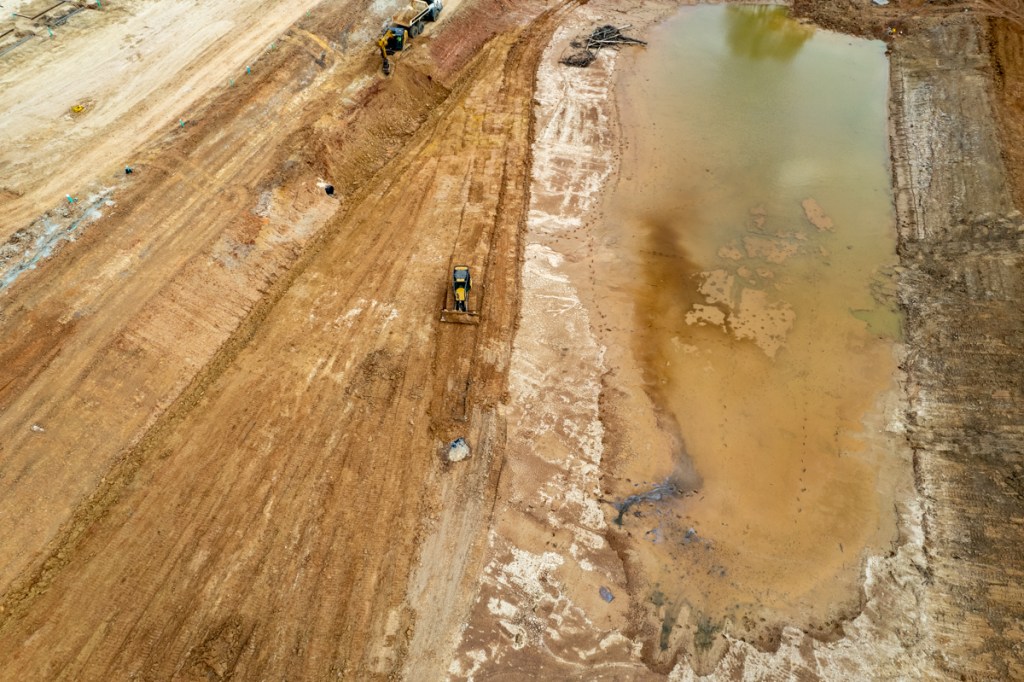
The detention basin at the Laurel Springs RV Resort was supposed to have been a dry-bottom pond. Despite one of the driest springs on record, it’s still holding water. And it’s still leaking into Harris County Precinct 3’s Edgewater Park. Despite:
The leak in question is in the exact place where contractors dug a trench through the south wall of the detention pond. They discharged silt that spread out for hundreds of feet into the wetlands of the park. Then they laid pipes in the trench and covered them up.
But somehow silty, oily stormwater still seems to be escaping into the wetlands from where the pipes were.
5/15/22
Photo taken 5/15/22. Leak in same area where trench and pipes were.Close up cropped from shot above. Note ripples on rushing water.
5/22/22
Same area photographed again on 5/22/22.Close up cropped from 5/22/22shot. Again note running water and oily film on it.
One wonders why the pumps in the approved drains are still not working. See bottom center in photo below.
Wide shot taken from over Laurel Springs Lane on 5/22/22 showing location of approved drain (bottom center) and extent of construction.Forms being laid for next concrete pour. Will there be enough space between RV slots to open doors? Picture taken from over railroad tracks.
Obviously, from all the standing water, they still have a little work left to do on drainage.
Still No Replacement Trees Planted
Photo taken on 5/18/2022 showing swath of trees that contractors cut in county park (left).
The developer also has a lot of work to do replanting trees. Note the wide swath outside the fence in the photo above that stretches for approximately 750 feet. That’s where the contractor destroyed trees in the county park.
Posted by Bob Rehak on 5/22/2022
1727 Days since Hurricane Harvey
The thoughts expressed in this post represent opinions on matters of public concern and safety. They are protected by the First Amendment of the US Constitution and the Anti-SLAPP Statute of the Great State of Texas.
https://i0.wp.com/reduceflooding.com/wp-content/uploads/2022/05/20220522-DJI_0526-2.jpg?fit=1200%2C799&ssl=17991200adminadmin2022-05-22 17:43:332022-05-22 20:13:03RV Resort Still Leaking Stormwater into County Park
Photo taken 3/5/22. Note difference of color in puddles just inches from each other.Wide shot also taken on 3/5 shows bulldozer filling in one black area while another leaks into pond. Note streak in water and see below.Also taken 3/5. Pond was being manually pumped into Lakewood Cove Storm sewer systemand thence into Lake Houston.The pumping explains the streak.On 3/10/22, I noted these black areas at the western end of the pond emerging from freshly bulldozed areas.Photo taken 3/11. The situation was worse and the bulldozers were back.On 3/14, the floor of the detention pond had been smoothed out, but the black spots were making another embarrassing comeback.Close up of same spot taken on 3/15.
I have dozens of other shots that show similar patterns. But you get the idea.
I asked the Railroad Commission if they could identify oil seepage from photos. The answer was no. But they did send an investigator out. Unfortunately, he arrived after everything had been covered up.
The contractor acknowledged the black spots, but claimed they were just seepage from rotting mulch. But why would a contractor place mulch below an area being excavated? That would just raise the level of the pond they were deepening. The mystery continues.
The Railroad Commission of Texas found no records of abandoned oil or gas wells on this property, although many are nearby.
As a show of good faith, I wish the developer would have an independent lab confirm what this stuff is now that it’s being pumped to a storm sewer system that feeds into Lake Houston.
Other Recent Activity
In other news:
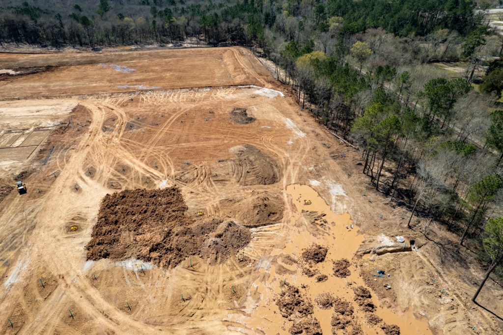
The developer has removed hundreds of truckloads of debris from below the detention pond.
They have excavated material from the southern walls of the pond and moved it north. This effectively shifted the pond back onto the developer’s property while elevating other portions of the property.
Contractors erected posts for what appears will be a chain link fence at the southern edge of the resort.
Contractors have finished tying the detention pond into the Lakewood Cove Storm Sewer system.
They also installed more underground drainage throughout the property.
The photographs below illustrate the points above.
Photo taken 2/23/22 shows part of debris pulled up from south of detention pond. Also note the black spots in the detention pond.Taken 3/16/22.Photo courtesy of reader. Used with permission.Note fence posts along left.These would appear to confirm the property boundary.The detention pond intake valve in the foreground is now connected with the pump housings on higher ground. However, the pumps may not yet be installed. And the housing still looks sealed off.Photo taken 3/15/22.Additional dirt is being brought in to raise the elevation of the site.Photo taken 3/13/22. Note water still ponding on site from a half inch of rain on 3/15. This soil is not as porous as the stormwater pollution prevention plan claims.Rebar being laid for the next concrete pouron 3/14/22.
Posted by Bob Rehak on 3/16/22
1660 Days since Hurricane Harvey
The thoughts expressed in this post represent opinions on matters of public concern and safety. They are protected by the First Amendment of the US Constitution and the Anti-SLAPP Statute of the Great State of Texas.
https://i0.wp.com/reduceflooding.com/wp-content/uploads/2022/03/Screen-Shot-2022-03-05-at-4.47.19-PM.png?fit=1984%2C1260&ssl=112601984adminadmin2022-03-16 20:20:412022-03-16 22:27:44Laurel Springs RV Resort Update: Mysterious Black Spots and Other News
Four months after Laurel Springs RV Resort contractors started tying into the Lakewood Cove storm sewer system, they may finally finish the job in the next few days. I spotted them yesterday and today, digging a trench from the pumps to the pond.
At their present rate of progress, and with gasoline prices spiraling out of control, one wonders whether RVs will be able to afford gas to get here when this job is complete.
Detention Pond Storm Sewer Tie In Started in Early December
Laurel Springs RV Resort detention pond drainage tie in as of 12/05/21. Contractor has tunneled under Laurel Springs Lane to Lakewood Cove storm sewer system on far side.Drainage plans approved by City of Houston for this portion of the job site. SE corner of detention pond below is in upper leftof diagram above.
Contractor Now Working on Approved Tie In
Wednesday around noon, 3/02/22, workers started excavating around the circular pump housing. By early morning 3/3/22, they had already laid the first section of pipe.By noon on 3/3/22, they had laid another section of pipe and were excavating their way to the corner of the pond.
Rec Center Being Framed Out
In separate news, workers started framing the RV Resort recreation building yesterday.
This shows the status on the morning of 3/3/22.
Spiraling Cost of Gasoline Could Affect Demand
I heard a story on the radio this morning that gasoline in Toronto has now topped $8.50 USD per gallon. With gasoline prices spiraling out of control, it’s unclear how many people will be traveling in RVs anytime soon. The larger ones get as little as 6 miles per gallon.
I remember taking a trip through the Yukon Territory several years ago when gasoline was half that price and seeing an RV fill up for more than $1000.
That’s comparable to the cost of a 2500 square-foot penthouse suite in a luxury 5-star hotel.
Now imagine doubling that cost to stay in something one tenth the size.
As they say in Hollywood, “Timing is everything in show business.” You could say the same for the RV park business.
Posted by Bob Rehak on 3/3/22
1647 Days since Hurricane Harvey
The thoughts expressed in this post represent opinions on matters of public concern and safety. They are protected by the First Amendment of the US Constitution and the Anti-SLAPP Statute of the Great State of Texas.
https://i0.wp.com/reduceflooding.com/wp-content/uploads/2022/03/20220303-DJI_0535.jpg?fit=1200%2C799&ssl=17991200adminadmin2022-03-03 15:16:502022-03-03 15:31:20RV Resort Detention-Pond Drain Finally Being Installed in Approved Location
Since development of the Laurel Springs RV Resort started last October, the Centerpoint easement below the development has turned into a small lake. It’s not clear at this point what caused the lake to develop. Several theories come time mind: increased runoff; sediment blocking drains; heavy January rains; poorly drained soils; illegal discharges; or some combination of the above. Regardless, this raises the most common question I encounter these days. “What happens when a developer builds its land up and sends water onto my property?”
Before Development
Here’s how the Centerpoint easement looked on October 25 last year when contractors started clearing land. Note the power lines in the small corridor left of the bigger one for railroad tracks. Also notice the tiny little ponds in the distance toward Hamblen Road at the top of the frame.
Looking SSE along the utility corridor and railroad tracks to the west of the RV resort shortly after clearing started on October 25, 2021.
According to Weather.gov, the 30 year average for October is 5.46 inches. So we got a little more than an inch above normal. Yet the corridor had only tiny amounts of ponding water.
January Photo Shows Ponds Expanding
On January 9, we had a large rainfall event and a photo that day shows the ponds expanded.
After heavy rains on 1/9/2022. Note small stream of water running down middle of utility corridor and two large ponds.
But also note how the larger pond in the distance stops well short of Hamblen Road in top right of frame.
February Rainfall One Third of Normal, But Ponds Continue to Grow
But since January 8/9, we’ve had very little rain. Nevertheless, the ponds have expanded into what one resident called a “lake” that blocked her hike down the utility corridor. See below.
Looking S toward Hamblen Road at top of frame. Pond now extends almost all the way to Hamblen.
The amazing thing is that the “lake” grew despite very little rain in February. As the chart below shows, we got 1 inch which is one third of the monthly average of 2.97 inches. Moreover, we got no significant rain for the 7 weeks before I took the picture above.
Yet the lake now stretches almost all the way to Hamblen! It’s getting bigger! So where’s the water coming from?
Water Not Coming West, East or South
It didn’t come from west of the railroad tracks. Union Pacific elevated those several feet above ground level.
Laurel Springs Lane has storm sewers that would have intercepted water from the east.
And water doesn’t usually flow uphill, so it didn’t come from the south either.
Much of it probably came from the north and the detention pond below which the developers drained into Edgewater Park on January 29.
Contractors drained detention pond into Edgewater Park on January 29.
Prior to that, they also pumped water over the wall of the pond.
Laurel Springs RV Resort pumping stormwater into Edgewater Parkon 1/18/2022.Then on January 31, contractors even tried to lay pipe through the wall of the detention pond to create a permanent conduit for stormwater into Edgewater Park.
Addition of Fill
They’re also bringing in fill to build up the RV Resort higher than the property around them. As they do so, they have been pushing standing water toward the utility corridor.
Looking west toward Centerpoint corridor just beyond tree line. Photo taken 2/10/22.
Lake Expands on One-Third Average Rainfall!
The bottom line is this.
Standing water in the Centerpoint utility corridor has increased as rainfall has fallen well below normal.
When you look around, there’s only one place this water could have come from.
I don’t want to beat this horse to death. But I get emails every day from people across northern Harris and southern Montgomery Counties. They worry about comparable issues. In essence, the emails say something like this: “A developer is building up land and flooding my property.”
I can understand the desire to build up land to avoid flooding on your own property. But we need to agree on ways to avoid flooding neighbors in the process. The answer probably lies in:
Better construction practices and training, i.e., sloping all land toward detention ponds.
Meaningful inspections and penalties by authorities.
Publication of the penalties.
Posted by Bob Rehak on 2/28/2022
1644 Days since Hurricane Harvey
The thoughts expressed in this post represent opinions on matters of public concern and safety. They are protected by the First Amendment of the US Constitution and the Anti-SLAPP Statute of the Great State of Texas.
How soon we forget. Hurricane Harvey was just 4.5 years ago. Since then I have documented dozens, if not hundreds of questionable practices that erode margins of flood safety.
It Didn’t Have to Be That Bad
Harvey was the largest rainfall event in the history of North America. However, with better regulations and construction practices, it didn’t have to be as destructive as it was.
Lax regulations;
Willful blindness;
Development and construction practices that pushed the safety envelope;
Relentless destruction of forests and wetlands near rivers and streams;
And homebuyers who didn’t realize their true flood risk…
…made Harvey’s destruction worse than it otherwise would have been.
No one factor by itself would explain Harvey’s destruction. But put them all together, and it’s like “death of a thousand cuts.”
The sheer volume of material – more than 1,000,000 words on this site – makes it difficult for people to see the big picture sometimes. To put 1,000,000 words into perspective, the average novel contains only about 100,000. So I’m condensing the website into a book that includes the themes below.
No One Wins Arguments with Mother Nature
During an interview with Milan Saunders and his daughter Lori, Milan said, “No one wins arguments with Mother Nature.” How profound! It doesn’t matter how many surveys, studies and engineer stamps you have on your home’s title. If you don’t:
Large islands built up during Harvey blocked both drainage ditches and rivers. Below, you can see a large sand island (top) built up at the confluence of the Kingwood Diversion Ditch where it reaches the San Jacinto West Fork at River Grove Park. This sand bar reached 10-12 feet in height above the waterline and helped back water up into Trailwood, the Barrington and Kingwood Lakes and Kings Forest. Before the Army Corps dredged this island, River Grove flooded five times in six months. It hasn’t flooded since.
The Kingwood Diversion Ditch and West Fork San Jacinto were almost totally blocked by sediment dams deposited during Harvey.
The second photo above was taken a few hundred yards downstream on the West Fork from the first. It shows “Sand Island” – so nicknamed by the Army Corps. It took the Corps months to dredge this island which they say had blocked the West Fork by 90%.
A certain amount of this sedimentation can be explained by natural erosion. But mankind also contributed to the sheer volume by other practices which I will discuss below.
Influence of sand mines of West Fork San Jacinto water quality.
End the War on Wetlands
Wetlands are nature’s detention ponds. During storms, they hold water back so it won’t flood people downstream. But we seem to want to eradicate wetlands. The images below show the Colony Ridge development in Liberty County. Wetlands (right) are being cleared (left) to make way for the world’s largest trailer park. The acceleration of runoff wiped out FM1010 during Harvey. The road still has not been repaired.
Colony Ridge in Liberty County.
Conservation Costs Much Less than Mitigation
Halls Bayou at I-69 near Fiesta. Image on left shows whole subdivisions that that to be bought out before detention ponds on right could be built.
Respecting Individuals’ Property Rights While Protecting Others’
In Texas, it sometimes feels that an individual’s right to do what he/she wants with property trumps others’ rights NOT to flood. You may think you’re protected by all those public servants reviewing and approving plans. But what happens when developers and contractors decide to ignore the approved plans? Here’s a prime example: the Laurel Springs RV Resort near Lakewood Cove.
About 10% of all the water coming down the West Fork at the peak of Harvey came from Crystal Creek in Montgomery County. But the wetlands near the headwaters of Crystal Creek are currently under development. And the developer is avoiding building detention ponds with a “beat-the-peak” survey. This loophole allowed by Montgomery County says that if you get your stormwater to the river faster than the peak of a flood arrives, then you’re not adding to the peak of a flood and you don’t have to build detention ponds. So developers conduct timing surveys to reduce costs and maximize salable land.
What happens when upstream areas develop without consideration for the impact on downstream property owners.
Of course, speeding up the flow of water in a flood is the opposite of what you want to do. To reduce flooding, you should hold back as much water as possible.
The graph on the right shows what happened on Brays Bayou without suitable detention upstream. Floodwaters peak higher, sooner. Harris County has spent more than $700 million in the last 20 years to remediate flooding problems along Brays.
How much will we need to spend when more areas like Mavera get built upstream on the West Fork?
How Quickly We Forget!
FEMA’s Base-Flood-Elevation Viewer shows that in that same area, developers have already built homes that could go under 1-5 feet of water in a 100-year flood. These homes are actually in a ten-year flood zone. And yet more homes are being built nearby. On even more marginal land!
In recent years, the price of land as a percent of a new home’s cost has risen from a historical average of 25% to approximately 40% today. This puts pressure on developers to seek out cheaper land in floodplains, reduce costs by avoiding detention pond requirements, pave over wetlands, and reduce lot sizes resulting in more impervious cover. All contribute to flooding.
Of course, smart homebuyers would not make such risky investments. But few lack the expertise to gauge flood risk. Educating such homebuyers will be one of the major objectives of the book I hope to write.
Posted by Bob Rehak on 2/23/2022
1639 Days since Hurricane Harvey
The thoughts expressed in this post represent opinions on matters of public concern and safety. They are protected by the First Amendment of the US Constitution and the Anti-SLAPP Statute of the Great State of Texas.
https://i0.wp.com/reduceflooding.com/wp-content/uploads/2019/11/RJR_4245.jpg?fit=1500%2C1000&ssl=110001500adminadmin2022-02-23 18:55:302025-08-19 22:13:53How Soon We Forget!
Construction activity at the Laurel Springs RV Resort near Lakewood Cove kicked into overdrive today as workers laid forms to prepare for concrete and more pipes went into the ground. Also, the detention pond seemed to change shape in ways that could reduce its capacity.
Getting Ready for Concrete
The shot below shows what will become the main entrance/exit opposite Mystic Glen Loop in Lakewood Cove.
Entrance/Exit to RV Resort. Concrete building pad for recreation center. The two rectangular areas in front of the three cargo containers will be the first RV pads. Blue pipes will carry fresh water.Plans that correspond to the photo above.Concrete forms also extend south toward the detention pond, out of sight at bottom of frame.
Baffling Work at Detention Pond
The work at the detention pond today was hard to explain. For the last few days, workers have pulled dirt and tree debris up onto the southwestern wall of the detention pond. Here’s how it looked yesterday around noon.
SW wall of RV Resort detention pond photographed on 2/17/2022.
Trucks have moved a portion of it to the western wall.
Looking east. Excavator loading debris onto truck which will back it around to the western wall (out of frame to the lower left). This and all photos below taken 2/18/22.Truck transplanting debris on western wall.
The wide shot below shows where they have been piling it on the western wall and puts the activity in context.
Looking South toward Edgewater Park in background.But it wasn’t all going to the western wall. Bulldozers spread some into the Laurel Springs RV Resort detention pond. The area where contractors laid pipe between the pond (left) and ponding water (right).Meanwhile, another bulldozer seemed to push dirt from the outside of the pond’s southern wall to the inside. It appeared as though contractors were attempting to shift the entire wall to the north. If accurate, that could reduce the pond’s already constrained capacity.
Did the developer’s surveyors make a mistake initially? We shall know soon enough if the County conducts its own survey.
If that tree debris gets plowed into the pond wall, it could weaken the structural integrity of the pond as the woody material decays.
The further along construction gets, the harder it is to undo mistakes if they happen. So we need to monitor this closely.
Posted by Bob Rehak on 2/18/22
1634 Days since Hurricane Harvey
The thoughts expressed in this post represent opinions on matters of public concern and safety. They are protected by the First Amendment of the US Constitution and the Anti-SLAPP Statute of the Great State of Texas.
https://i0.wp.com/reduceflooding.com/wp-content/uploads/2022/02/20220218-DJI_0059.jpg?fit=1200%2C799&ssl=17991200adminadmin2022-02-18 20:45:272022-02-18 20:45:31RV Resort Getting Ready to Pour Concrete, Baffling Activity at Detention Pond
One thing became immediately clear after reviewing aerial photos of the Kingwood area’s first RV resort last Monday. The heavy rains created a mud pit. After removing every tree and blade of grass on these 20 acres, the owners of this project will have to pave over virtually the entire site to make it useable.
I took all photos below on Sunday morning 1/9/22 after heavy rains stopped, but between sporadic light rains.
Laurel Springs RV Resort after Heavy Weekend Rains
Looking NW from over Laurel Springs Lane at Kingwood’s first RV resort and its detention pond after a 5.5 inch rain.
Silt seems to be piling up along silt fence on right, an indication of how site is sloped.
Contractors are starting to build roads. But look at ponding on either side of first one.
Looking SSE across RV resort from over UP railroad tracks at Lakewood Cove.
Rains can delay construction by making it difficult to work the ground.
Note drainage running down Centerpoint utility corridor.
Note heavy erosion and debris in detention pond.
Currently lip of detention pond is below road level. Overflow from pond will likely go into Edgewater Park’s cypress ponds below hill.
Bad News, Good News
Most of the initial fears that Lakewood Cove residents had about this site remain valid. Railroad noise. Traffic safety. Road destruction. School impact. And more.
However, after seeing the response of the site to last weekend’s heavy rains, I’m less concerned about the site flooding Lakewood Cove if the southern lip of the detention pond remains at its current height.
Presently, the pond lip is much lower than the road as you can see in the photo above. If it stays that way, overflow stormwater will go down the hill west of Laurel Springs into what will soon become Precinct 4’s new Edgewater Park.
However, there’s also a significant amount of dirt piled on the northern lip of the pond. It’s unclear where contractors will put that. If they use it to build up the southern lip, that could change the game.
Clearly, the owners lucked out with the timing of this storm. They substantially completed the detention pond before the storm. Otherwise, this could have turned into another Woodridge Village/Elm Grove situation.
Posted by Bob Rehak on 1/14/2022
1599 Days since Hurricane Harvey
The thoughts expressed in this post represent opinions on matters of public concern and safety. They are protected by the First Amendment of the US Constitution and the Anti-SLAPP Statute of the Great State of Texas.
https://i0.wp.com/reduceflooding.com/wp-content/uploads/2022/01/20220109-DJI_0406.jpg?fit=1200%2C799&ssl=17991200adminadmin2022-01-14 16:11:342022-01-14 16:21:34Photos of Kingwood’s First RV Resort after Heavy Rains Last Weekend
An angry Houstonian wrote me earlier this week about a new RV park. It lies mostly in the floodway of Luce Bayou next to Huffman/Cleveland Road – near rotting shells of abandoned homes, repeatedly flooded. This is inside the City of Houston. So the City permitted it, not Harris County.
“The Retreat” Will Debut This Year
The developer bills it as an RV and camping resort called The Retreat. Copy says, “The premier destination is planned to include RV camping sites, cabins, tiny homes, wagons, and elevated yurts. Families, couples, and groups of all ages can enjoy fishing, kayaking, paddle boarding, walking trails, boating, outdoor games, lounging at the pool, and more!” Sounds idyllic until you drive around in the surrounding neighborhoods and see all the flood wreckage.
Is This Type of Development Safe for This Location?
I’m sure the developer will argue that:
The RVs are technically vehicles that can be moved out of harm’s way when floods come up.
Any permanent structures are built on higher ground in the 500-year floodplain.
A retention pond will offset any increase in runoff.
But do these arguments really hold water?
Will owners have time to evacuate everyone?
Will the ground be high enough after floodplain maps are redrawn?
How much water will the detention pond hold back if the river exceeds its banks?
During Harvey, people up and down the West Fork woke up in the middle of the night with water coming into their homes.
An architect who designs RV resorts told me it can easily take a novice half an hour to lower the trailer; disconnect electricity, water and septic lines; and hitch up a truck – in ideal conditions.
Now imagine you’re doing it during an intense rainfall and moving to the exit with a hundred other campers…at night…onto a two lane blacktop road…as the bridge goes under water…and the kids are crying.
How High is High Enough?
According to the Weather Channel, just two feet of water is enough to carry away most vehicles. They also say that water levels in flash floods can rise a foot in just five minutes. Six inches of water will reach the bottom of most passenger cars, causing loss of control and potential stalling. Finally, they say that water flowing at just 7 mph has as much force per unit area as wind in an EF5 tornado.
During Imelda, Archie Savage and Rosemary Fain, who live upstream, documented water bridging from the East Fork San Jacinto to Luce Bayou. If that happened again, campers could find themselves potentially cut off from escape routes.
Worse, flood maps have not yet been updated from Harvey and Imelda. The new 100-year flood is based on roughly 30-40% more rainfall. So floodways and floodplains in updated maps will soon expand beyond those shown below.
This image shows the location of the developer’s property between Luce Bayou and Huffman-Cleveland Road. The inter-basin transfer canal cuts across the bottom of the frame and FM2100 cuts diagonally through the upper right.Lake Houston is out of frame at the bottom.
FEMA’s National Flood Hazard Layer Viewer shows the extent to which the floodway and floodplains of Luce Bayou infringe on the property.All but the northwest corner near the letter “I’ is currently in a floodplain or floodway. That could soon change when flood maps are updated from Harvey.
FEMA’s base flood elevation viewer shows that in a 100-year flood, about three quarters of the property would go under 5 or more feet of water.Another 10-20% would go under 1-4 feet. Again, these maps are based on pre-Atlas 14 data.
The Retreat RV Resort and Campground
The lower part of the property is just a few feet about the river level.
Looking south toward the Huffman-Cleveland Road Bridge over Luce Bayou.
The detention pond actually appears to be several feet lower than the bayou. That won’t hold back much water in a flood. Note the green color.
No Prohibition, But Plenty of Warnings
Evidently, no laws or regulations prohibit this type of development. Chapter 19 of the City Code of Ordinances contains floodplain regulations but does not address recreational vehicles. Chapter 29 addresses recreational vehicles but does not address floodplains.
However, a website called RVParkUniversity.com which advises RV Park investors says, “RVs do float – but they’re not designed to. Floodplain and RVs do not get along well. So if you’re looking at buying an RV park that has “floodplain” shown on the survey, it cannot be taken lightly. Flood plains destroy your ability to obtain a loan, find a future buyer, and create huge liability for you with your customers.”
Also, the Texas Water Development Board advises people camping near water to ask the park operator about flood warnings and evacuation plans. The State does have regs that govern RV parks in floodplains. The problem is, the rules are easily circumvented. For instance, people can not leave campers in the same location for more than 180 days. But nothing prevents owners from getting around that by moving them to the next pad. In this way, temporary recreational amenities become permanent residences.
Up and down the East Fork, developers are building more such facilities.
Yesterday, I posted about how we often sow the seeds of our own disasters. This could be one of those cases in the making. Are we putting people in harm’s way without anticipating the speed or magnitude of the next big flood?
Posted by Bob Rehak on February 26, 2021
1277 Days since Hurricane Harvey and 526 since Imelda
The thoughts expressed in this post represent opinions on matters of public concern and safety. They are protected by the First Amendment of the US Constitution and the Anti-SLAPP Statute of the Great State of Texas.
https://i0.wp.com/reduceflooding.com/wp-content/uploads/2021/02/RV-Resort-Outline.jpg?fit=1200%2C827&ssl=18271200adminadmin2021-02-26 19:53:172021-02-27 09:21:22RV Park Being Built in Luce Bayou Floodway, Floodplain