Geologists use the term “mouth bar” to describe a sand bar that forms at the mouth of a stream. Where moving water meets standing water, the velocity slows and sediment drops out of suspension, forming a mouth bar. Mouth bars reduce the conveyance of a stream, forcing water up and out during floods. Removal of mouth bars reduces flood risk.
After Harvey, Rogers Gully had the largest mouth bar on the perimeter of Lake Houston with the exception of the West and East Forks of the San Jacinto. Jessica Beemer with Mayor Pro Tem Dave Martin’s office said they do not yet know where the dredgers will go next.
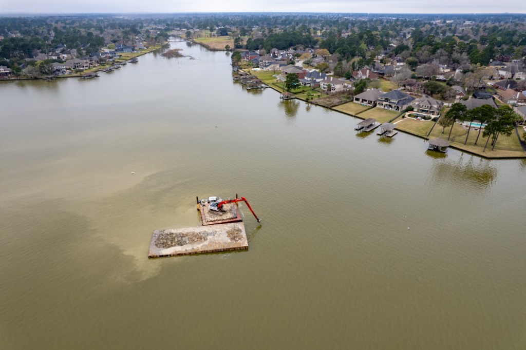
Before Picture
Mouth bar in February of 2020. Note HCFCD excavating channel further upstream in upper left of photo. The City of Houston owns the portion of the channel in foreground.
Looking west, upstream on mRogers Gully. 6/2/22.No more mouth bar!Wider shot from farther back, looking upstream from over Lake Houston. 6/2/22.Shot taken looking east on 6/2/22.Hauling the spoils to the east side of the Lake. 6/2/22.
When last I reported on Lake Houston dredging, the focus of operations had shifted from the East Fork to Rogers Gully. However, the dredgers were still stationed hundreds of feet offshore. According to State Representative Dan Huberty, shallow water forced them to dredge their way into the Gully. (See below.)
Location of dredge on March 1, 2022.Mouth bars, like the one in the foreground are deposited where water slows down as it reaches the lake.
Compare Photos Taken Today
Now, 2.5 months later, the dredgers have reached the Rogers Gully mouth bar and have completed dredging most of it.
Looking east toward Lake Houston. Compare photo above.Looking west toward the Walden Country Club, upper right.
Aerial photos taken this afternoon show that all but a small portion has already been removed. The operation could be completed in the next week or two, weather permitting.
Pontoons ferry the spoils to a converted marina across the lake now used as a temporary placement area. From there, trucks take the spoils to a fill-dirt company on FM1960 near SH99 east.
Before Dredging Began
To appreciate the progress, compare the photo below taken two years ago.
Rogers Gully Mouth Bar on June 16, 2020 before dredging started.
It’s not clear yet where the dredges will go next. They’re on a mission, with money that Huberty helped obtain from the legislature, to open up more ditches and streams that empty into Lake Houston. Blockages like the one at Rogers Gully can reduce the conveyance of streams. They create sediment dams that back water up. And that contributes to flooding homes and businesses behind them.
I went back to see how much of the mouth bar remained this morning and was shocked. The two dredges are still sitting far offshore, approximately where they were on March 1.
Here are several pictures that show their position this morning, 3/11/22.
Looking west from the mouth of Rogers Gully toward the dredges about a quarter mile away and the eastern shore of Lake Houston in the background.Reverse angle. Looking over one of the two dredges toward the mouth of Rogers Gully.
Curious about why the dredges were working so far out, I asked State Representative Dan Huberty “Why?” Huberty, who secured money for the dredging, texted back a one-line answer.
“Can’t get into Rogers Gulley without dredging their way in.”
It’s been almost two weeks since they started working here. And this area is far wider than the Royal Shores channel. Rogers Gully has apparently formed a wide and long “underwater” delta that extends far beyond the above-water portion.
So in answer to the question in the headline, “How blocked up is Rogers Gully?” It’s baaaad.
https://i0.wp.com/reduceflooding.com/wp-content/uploads/2022/03/20220311-DJI_0742.jpg?fit=1200%2C799&ssl=17991200adminadmin2022-03-11 16:22:472022-03-11 16:24:20How Blocked Up Is Rogers Gully?
Within the last week, the focus of dredging moved from the East Fork San Jacinto to the mouth of Rogers Gully on the west side of Lake Houston near the Walden Country Club. HCFCD conducted a dredging operation upstream from the Rogers Gully mouth bar in 2020. But the mouth bar itself is in Lake Houston, which is owned by the City of Houston. So this portion is the City’s responsibility.
Where dredging stopped in East Fork in late February. Looking South. Luce Bayou on upper left. FM1960 Bridge in upper right.Picture taken 2/27/22.Rogers Gully mouth bar has already been partially removed by the dredgers anchored in the distance for the evening.Looking east toward Huffman on far side of lake from over the Walden Country Club.Photo taken 3/1/22.
New Base of Operations Will Shorten Supply Lines
At the same time, the base of operations for dredging appears to be moving from the West Fork to a marina across the lake from Rogers Gully. The new drop off point for spoils is about 2.2 miles from Rogers Gully. Compare that to almost 7 miles to get from the East Fork to Berry Madden’s property south of River Grove Park on the West Fork.
New deposit site for dredging spoils on Fairlake Lane in Huffman.Photo taken 2/27/22.
Over the weekend, I photographed dredgers preparing the site and carting the first loads of sediment to a dirt/mulch company about six miles east on 1960.
Where spoils from Lake Houston are going on FM1960 toward 99.
The dirt company is about 2 miles inside the new Grand Parkway extension.
Looking south. New Grand Parkway extension crossing FM1960. Photo taken 2/27/22.
The new highway will open vast new areas for development and create ready markets for dredging spoils to elevate homes and build roads.
Focus Shifting to Inlets Around Lake
According to State Representative Dan Huberty, about $40 million remains in the dredging fund appropriated by the state legislature last year. He hopes that after inlets around the lake are cleaned out, that dredgers will return to the East Fork in the future to continue the effort there.
Pictures taken this afternoon show that in the last two days, the dredgers have taken a significant bite out of the Rogers Gully mouth bar, which in my opinion, was the worst of many smaller inlets around the lake.
Rogers Gully mouth bar in August of 2020. Compare to photos below to see progress already made.
The photos below tell the story.
Looking west from beyond one of the anchored dredges toward the mouth bar and the Walden Country Club in the top center.Still looking west at the partially removed mouth bar.Looking NNW.From here, tugs will ferry the pontoons toward the general vicinity of that white spot on the lake front in the upper right.Note the FM1960 bridge in the background.
Soon, the dredgers will finish with Rogers Gully and move on to the next inlet.
Posted by Bob Rehak on 3/1/22 with input from Dan Huberty
1645 Days since Hurricane Harvey
https://i0.wp.com/reduceflooding.com/wp-content/uploads/2022/03/20220301-DJI_0429.jpg?fit=1200%2C799&ssl=17991200adminadmin2022-03-01 19:01:142022-03-01 19:09:52Dredgers Move to Rogers Gully from East Fork
In January, the City hired DRC Emergency Services, LLC (DRC) to begin mechanical dredging of the San Jacinto West Fork Mouth Bar. I’ve provided periodic updates on that. According to Houston Mayor Pro Tem Dave Martin, DRC has now officially completed 60% of that project.
In the meantime, other related dredging projects, including East Fork dredging and long-term Lake Houston maintenance dredging are reportedly taking shape. Here’s how pieces of the puzzle fit together. But one piece is still missing – long-term funding to pay for the maintenance dredging.
Two-Phase Program
DRC’s scope of work has two distinct phases:
Phase One will remove accumulated materials near and at the mouth bar on the West Fork of the San Jacinto River.
Phase Two will remove accumulated materials in the East Fork of the San Jacinto River AND other locations in Lake Houston.
West Fork Mouth Bar as of late June 2020.
During Phase One, 400,000 cubic yards of material will be removed over twelve months. To date, DRC has removed approximately 240,080 cubic yards of material. (See photo above.) That’s 60% in approximately 60% of the allotted time, so that part of the project is on schedule.
East Fork Mouth Bar as of May 2020. This areas went from 18 to 3 feet deep during Imelda, according to boater Josh Alberson. The above-water portion of this sand bar has grown three quarters of a mile since Harvey.
Phase Two of the project will consist of:
Hydrographic surveys of the West Fork of the San Jacinto River, the East Fork of the San Jacinto River, and Lake Houston to determine dredge material volumes
City of Houston advertising and awarding a dredging contract to the lowest responsive bidder
Phase Two will run simultaneously with Phase One to expedite dredging.
Dave Martin, Houston Mayor Pro Tem
Mayor Pro Tem Martin did not provide an update on where Phase Two currently stands. But residents have reported seeing survey boats on Lake Houston, and the East and West Forks of the San Jacinto.
Mouth bar forming at Rogers Gully on Lake Houston. Example of kind of projects being considered for Phase 2.Photo late June, 2020.
Long-Term Dredging Plan in Development
Additionally, during Phase Two, City of Houston and its partners will develop a long-term dredging plan for Lake Houston. City of Houston or the Coastal Water Authority will execute the plan.
The intention: to fund dredging operations in perpetuity.
This phased approach will obligate the full grant funding before the 87th legislative session in 2021. This grant funding was made possible thanks to State Representative Dan Huberty (District 127) through the passage of Senate Bill 500.
Mayor Pro Tem Martin credits Huberty for his dedication to the long-term maintenance dredging activities on Lake Houston. “Representative Huberty has been a champion for his residents and a great ally in seeing these additional dredging efforts come to fruition,” said Martin.
$40 Million Project
The total project is valued at $40 million (except for the perpetuity part). Funding for the immediate dredging projects comes through a combination of:
City of Houston Harvey Disaster dollars provided by Governor Greg Abbott
Grant dollars from the Texas Water Development Board (TWDB)
Harris County Flood Control District (HCFCD) Bond Program.
Long Term Funding – Still A Missing Piece of Puzzle
Lake Houston, a City of Houston asset, is losing capacity. Everyone has recognized that fact for decades. But as silt filled the rivers, inlets and lake, maintenance was deferred, reportedly for budgetary reasons. In 2017, during Harvey, the problem became so big that no one could ignore it anymore. Flooding was the immediate problem. But loss of water capacity is an even bigger, longer-term problem.
It’s one thing to have a long-term maintenance dredging plan and another to put it into action. But where will the money come from?
A tax on sand mines? Won’t work. Most aren’t in the City. Or even in Harris County.
Some have suggested creating a taxing district for lakefront homeowners. That won’t work either. Not enough of them. And it would create a stampede for the Oklahoma border. Moreover, it hardly seems fair; the lake is part of a City system that provides water to two million people and generates revenue.
The logical solution seems to be increasing the cost of water. Adding just a fraction of a penny per 1000 gallons should do it. Dredging isn’t just about reducing flooding. Or preserving views for lakefront homeowners. It helps preserve the lake’s capacity. And that benefits everyone.
As we develop a long-term dredging plan for the lake, we also need to consider a sustainable source of financing.
Posted by Bob Rehak on 8/12/2020based, in part, on a release by Houston Mayor Pro Tem Dave Martin
1079 Days after Hurricane Harvey
https://i0.wp.com/reduceflooding.com/wp-content/uploads/2020/08/20200306-RJR_9786.jpg?fit=1200%2C800&ssl=18001200adminadmin2020-08-12 13:45:302020-08-12 16:03:12Long-Term Lake Houston Dredging Plan in Development; West Fork Mouth-Bar 60 Percent Completed
Correction on 7/4/2020: The article below was based on a City of Houston District E newsletter. It inferred that the City “applied for” five grants (in bullet points below). Other entities, such as the SJRA, applied for those. Mayor Pro Tem Dave Martin personally supports them.
The City of Houston has submitted several applications to the Texas Water Development Board (TWDB) for Flood Infrastructure Fund dollars. Among the projects was one for Taylor Gully Flood Damage Reduction. It consists of evaluating flood reduction alternatives plus design, permitting, and construction of a detention basin located on a 278 acre site to the north of the Elm Grove subdivision.
Looking SW atWoodridge Village as of 6/16/2020
Woodridge Project One of Six Apps
Other applications include:
San Jacinto River Sand Trap Development
Spring Creek Watershed Flood Control Dams Conceptual Engineering
Upper San Jacinto River Basin Regional Sedimentation Study
Lake Conroe-Lake Houston Joint Reservoir Operations Study
Harris County MUD #153 Siltation Reduction
“All of these projects submitted for funding promote regional resiliency and future sustainability in an effort to protect life and property from future flooding,” said Mayor Pro Tem and District E City Council Member Dave Martin. “The ability to submit these projects to the TWDB for funding would not be possible without State Senator Brandon Creighton’s writing of Senate Bill 7. We continue to applaud the Senator for his forward thinking and hope to receive funding for these projects. State Representative Dan Huberty has also been a vocal proponent for resiliency within our area and just beyond the City boundary. We are thankful to have him as a local engaged leader.”
Looking NW from US59 (foreground) over San Jacinto West Fork at the confluence of Spring Creek (left) and the West Fork (right). Spring Creek splits off to left. Its watershed contains several natural areas that might make candidates for flood control dams.
Neither Martin, nor his office, provided additional details on any of the grant applications.
However, from the wording of the release, it sounds as though state leaders are fully aligned and engaged to support the projects.
Woodridge Village Project Has Long History
The grants, if approved, could help reduce flooding throughout the Lake Houston Area.
Both the City and County have been silent on any deal since then. The County refused a Freedom of Information Act request to release the text of the motion, which was approved in a public meeting. They even protested release of the information to the State Attorney General.
Putting Application in Historical Context
The following is speculation, but speculation based on the historical context. It appears that when County Commissioners voted to demand that the City come up with half the the purchase AND construction costs, the City found it hard. The grant application, if successful, is a way for the City to help the people of Elm Grove, who flooded twice last year after Perry Homes cleared 268 acres of adjacent land.
At the time of the floods, less than 25% of the planned detention pond capacity was in place. Perry has since developed additional detention ponds that provide the other 75%.
A joint reservoir operations study seems necessary. Currently, FEMA is funding a preliminary engineering study to add additional gates to the Lake Houston Spillway. If FEMA also approved the money for construction of the gates, they will be a game changer.
The Spring Creek Watershed flood control dams would provide additional upstream detention. Community leaders identified that as a high priority after Harvey. They would reduce the amount of water coming downstream during a flood.
Sand bar blocking mouth of Rogers Gully has backed up water and contributed to flooding. Photo taken 6/16/2020.
Posted by Bob Rehak on 7/3/2020
1039 Days since Hurricane Harvey
https://i0.wp.com/reduceflooding.com/wp-content/uploads/2020/07/20200616-RJR_4383.jpg?fit=1200%2C800&ssl=18001200adminadmin2020-07-03 11:55:542020-07-04 14:02:25City Applies for TWDB Grants to Turn Woodridge Village Into Detention Basin and More
Aerial photos taken on April 21, 2020 show that Harris County Flood Control District (HCFCD) finished its Rogers Gully project in the Walden area of Lake Houston south of FM1960. However, a significant mouth bar remains in the portion of the ditch owned by the City of Houston.
Looking west from shoreline of Lake Houston. Harris County Flood Control excavated accumulated sediment earlier this year in the visible portions of Rogers Gully.Looking east from same position, shows work still remains in the City-owned portion of Rogers Gully.
Project Did Not Extend to Lake Houston
The channel repair project extended from Trophy Place to approximately 1,400 feet downstream. Matt Zeve, Deputy Executive Director of HCFCD, said “We had worked this location a year ago, and the sediment accumulated in this spot again very quickly, so we had to come back.”
However, he added, “We won’t be getting the mouth bar.” The mouth bar is yet another one of the jurisdictional issues that plague homeowners around Lake Houston. The map below shows the HCFCD right-of-way in yellow. City of Houston (COH) is the red (actually COH owns all of the lake area even though it doesn’t show up on the map).
HCFCD excavated the yellow portion of Rogers Gully.
Zeve also said, “The mouth bar will have to be handled by another dredging contract that will come after the COH executes the $30 million program.” The $30 million program refers to the Huberty Amendment to SB500 passed during the last legislature.
The April photo of the mouth bar above was taken after a large rain when the lake level was up slightly. When the level is down, here is what the problem looks like.
The Rogers Gully mouth bar still appears to have the potential to back water up and contribute to neighborhood flooding.
Posted by Bob Rehak on 5/10/2020
985 Days after Hurricane Harvey and 234 after Imelda
https://i0.wp.com/reduceflooding.com/wp-content/uploads/2020/05/20200421-RJR_1184.jpg?fit=1200%2C800&ssl=18001200adminadmin2020-05-10 14:27:342020-05-10 14:29:32HCFCD Finishes Clean-Out of Its Portion of Rogers Gully; But Mouth Bar Remains