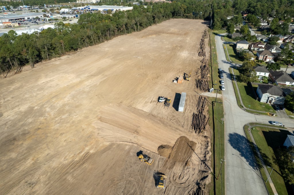
Clean Sweep for RV “Resort” Owners
As of Friday morning, 11/19/21, only about a half dozen trees remained standing on the 20-acre site of what will soon become the Kingwood area’s first RV “Resort.” At this point, they will need to rename it the RV Resort and Tanning Salon. All the trees that used to provide shade will soon be replaced by concrete that will broil RV owners in the Texas sun. And when it’s raining, that concrete will accelerate runoff and exacerbate flooding – because the detention pond is designed to hold only about half of the runoff required by the current City standard.
Making Room for 226 RVs on Site Permitted for 182
Last month, the City of Houston approved plans for 226 RVs on a site permitted for 182 and the denuding of the site began almost immediately. Despite multiple irregularities in permit approvals and concerns about the drainage impact on neighboring Lakewood Cove, construction of this concrete desert is moving forward relentlessly and, some say, remorselessly.
To my knowledge, this will be the first commercial venture in the Kingwood Area directly opposite a residential neighborhood without a green-space buffer between them.

Those buffers, usually in the form of trails and greenbelts, give Kingwood its distinctive character.
However, while the RV park will be in the Kingwood Area, technically it will not be Kingwood per se. So Friendswood deed restrictions do not apply. And the property seems to have no other deed restrictions, at least none that I can find.
What Kind of Traffic Will RV “Resort” Attract?
Aside from sunbathers, what kind of people will the Laurel Springs RV “Resort” attract?
Chapter 29 of the City of Houston Code of Ordinances permits several different types of vehicles in RV Parks. They include:
- Camping trailers for a period not to exceed 30 days in any consecutive six-month period. They may be used for sleeping and living purposes during that time.
- Self-contained motor homes, truck campers and travel trailers with a minimum 120 SF of floor space for up to six months within any consecutive twelve-month period.
- Motor homes, truck campers or travel trailers with a minimum 84 SF of floor space that are not self-contained for up to 30 days within any consecutive twelve-month period.
- Travel trailers without a time limitation if connected to park utilities, water supply and sewer system. They must have at least 120 square feet of floor space for the first occupant and at least 30 square feet for each additional occupant. Other conditions such as hot water, heating, etc. also apply.
Hmmmm. That last category may be a way to get your kid into Humble ISD schools without buying a home or even renting an apartment.
I have not yet found any information about how the owners intend to market the RV Resort.
Shell Companies Behind the Project
Two men, Clay McDaniel and Richard Rainer, are responsible for developing the site. They have insulated themselves from liability with several layers of corporations.
Laurel Springs RV, LLC, managed by Rainer and McDaniel, owns the property.
But the Plat shows McDaniel as a manager and Rainer as a manager/owner.
A TCEQ permit (see below) posted at the site shows LS RV Resort, LP, is the secondary “operator” of the site. (A contractor is the primary operator; the secondary operator supervises the primary operator.) Rainer signed the LS RV Resort permit and listed himself as Manager. Laurel Springs RV, LLC is LS RV Resort, LP’s general partner.

Rainer and McDaniel also own a company called Excel Commercial Real Estate, LLC. Their website claims they offer “…diverse experience … to each detail of the real estate development, management and ownership process.”
The two founded Excel in 2005 to “conceive, design, and build income producing real estate.”
Excel’s website shows they concentrate on small strip centers, self-storage buildings, and manufactured home parks.
A search of the Secretary of State’s website shows that Rainer plays some kind of role (manager, director, registered agent, director, VP, president or governing person) in approximately 70 different entities.
McDaniel is even more prolific. The Secretary of State shows McDaniel’s name attached to more than a hundred different entities, often in multiple capacities.
Rainer and McDaniel control more than 100 different companies or partnerships.
According to one developer I talked to, the large number of companies may indicate that spinoffs are part of their business strategy. And in fact, many of the projects shown on Excel’s website are listed as “sold.”
Irony
Rainer and McDaniel list 9121 Elizabeth Road, Suite 108, Houston, TX 77055 as the address for Excel; Laurel Springs RV, LLC; and LS RV Resort LP. That property is covered with trees and on a tree-lined street…where all the trees are vertical.

How ironic that all the trees on Laurel Springs RV Resort are now horizontal!
Posted by Bob Rehak on 11/19/21
1543 Days after Hurricane Harvey
The thoughts expressed in this post represent opinions on matters of public concern and safety. They are protected by the First Amendment of the US Constitution and the Anti-SLAPP Statute of the Great State of Texas.


