Tag Archive for: release rates

Lake Conroe Release Rate at 90% of Harvey

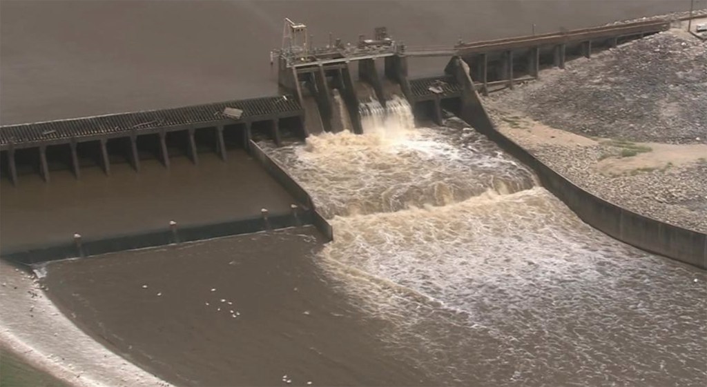
5/2/24 at 4:30 PM – The San Jacinto River Authority (SJRA) is releasing water at the rate of 69,545 cubic feet per second (CFS from Lake Conroe. That’s down a couple thousand from the 71,835 they released earlier this afternoon, the second highest release rate ever – 90% of the all-time record of 79,000 CFS during Hurricane Harvey.

At that rate, NOAA predicted the San Jacinto West Fork at US59 would peak at 62.4 feet. Since then, they’ve reduced that back a bit to 62.2.

However, the level of Lake Conroe is still rising slightly. It stands at 205.13 MSL (mean feet above sea level) as of 4:30 PM.

And local leaders including Houston Mayor John Whitmire, State Rep. Charles Cunningham and City Council Member Fred Flickinger met in Kingwood to plan emergency response with first-responders.

More Rain on Way

The level of Lake Conroe is up significantly since this morning. And another rain storm is headed our way tonight. The National Weather Service predicts a 40% chance of more thunderstorms tonight. Anything that falls will be on top of almost 7 inches of rain received in the Kingwood area earlier today.

Flood watches and warnings remain in effect at the present time. Any new rain will fall onto already saturated soils, resulting in rapid runoff.

SJRA Pushing Up Against Limit

But the SJRA is running out of room. At 207, they flood Lake Conroe homes and endanger the dam, according to Mark Micheletti, an SJRA board member who lives in Kingwood.

Micheletti has demanded that SJRA operators throttle back releases as soon as they stabilize the Lake Conroe’s level. The SJRA hopes to keep a safety margin by not letting the lake level get above 206, but nature, not engineers will make that call.

Meanwhile, the uncertainty has many Kingwood people in panic mode wondering whether they should evacuate. I’ve been deluged (pardon the pun) with requests for information.

Whitmire Visits Kingwood to Plan Flood Response

Houston Mayor John Whitmire came to Kingwood this afternoon to meet with first responders and area leaders. He wanted to personally see the situation and assess what the area needs. He met with Fire Chief Samuel Peña, first responders, State Representative Charles Cunningham and City Council Member Fred Flickinger at Fire Station 102 on West Lake Houston Parkway.

CM Fred Flickinger (center) met with Mayor Whitmire (right), Chief Samuel Peña (left) and other first responders at Fire Station 102 this afternoon on West Lake Houston Parkway.

Peña emphasized the need for vehicles to stay out of high water. The fire department had already made numerous high water rescues today.

State Representative Charles Cunningham (left) also helped plan the emergency response.

At the meeting, Whitmire also said that he had discussed evacuation orders for certain subdivisions with Harris County Judge Lina Hidalgo. After Harvey, “communication with residents” and “warning time” were identified as two of the primary things officials needed to improve.

Current East Fork Predictions and Evacuation Orders

According to Harris County Meteorologist Jeff Lindner, the County has issued evacuation orders for the east side of the East Fork San Jacinto from FM1485 to Lake Houston. (Lake Houston Park is on the west side.) Forecasted water levels will rise 7-8 feet higher than earlier this week. Structures on the ground will be flooded to rooftop levels. Elevated structures will be flooded.

For reference, the forecasted East Fork water level is 3 ft below Harvey.

Impacted subdivisions: 
  • Idle Wilde
  • Idle Glen
  • Cypress Point
  • River Terrace
  • Magnolia Point
  • Northwood Country Estates

Current West Fork San Jacinto Predictions and Warnings

The West Fork is rapidly rising from upstream inflows. It will reach major flood levels and will rise to near 62 ft on Saturday. Widespread low-land flooding will occur impacting the following subdivisions:

  • Belleau Woods
  • Rivercrest
  • Northshore
  • Forest Cove
  • Kings Point
  • Atasocita Shores

In Kingwood, Lindner expects flooding of streets and the lowest structures nearest the river. He also predicts backwater impacts along the tributaries. That means high river levels could force water in channels and tributaries to back up.

The following areas will be completely flooded with several feet of water: Deerwood Country Club, Deer Ridge Park, and Kingwood Country Club.

Elevated residents near the river should be prepared to be cut-off through the weekend.

I have queried HCFCD about the list of subdivisions above. It seems incomplete. But I have not yet heard back.

San Jacinto River Below Lake Houston

Major flooding is expected at all locations along the lower portions of the river.

Rio Villa will be completely inundated and cut-off. 

High velocity flows may damage vessels and barges near I-10.

Flow may approach and potentially reach I-10 on the west side of the river.

Real Time Inundation Monitoring

To monitor what’s going on around you, Harris County Meteorologist Jeff Lindner suggests using the Real-Time Inundation Mapping Tool found in the Harris County Flood Warning System. From the home page, just click “Inundation Map” in the upper left tool bar, then zoom into the area of interest.

As of 4:22 PM on 5/2/24. Note large areas already inundated.

Easy Way to Find the Elevation of Your Home

Don’t know the elevation of your home? Consult this post about how to find it in the USGS National Map.

More updates later. SJRA may issue another statement at 8PM.

Posted by Bob Rehak at 4:30 PM, Thursday, May 2, 2024

2438 Days since Hurricane Harvey

Pre-Storm Lake- and River-Level Report

With major rainfall expected this week, here is a pre-storm report on lake and river levels.

Lake Conroe Pre-Storm

Even though Lake Conroe has released water continuously since April 1, the SJRA has not succeeded in reducing the lake level to their seasonal target of 200 feet. They were close at one point, but recent rains have elevated the lake back to its normal pool level. As of this writing, the lake is at 200.87 feet. Normal level is 201 mean feet above sea level. Thus Lake Conroe is only down about one tenth of an inch despite the fact that the SJRA continues to release water at the rate of 522 cubic feet per second.

Lake Conroe levels for the last week. On May 1, the SJRA increased the release rate from about 350 cfs to 522 cfs. Despite that, the lake has risen back to its normal level because of recent rains.

Here’s a picture of the massive gates at Lake Conroe. Compare them to…

The gates at Lake Conroe can release water at up too 150,000 CFS but are currently releasing at only 522 CFS to avoid flooding downstream areas.

Lake Houston Pre-Storm

Lake Houston has its gates wide open. At that setting, they can release 10,000 CFS. But the recent rains are also refilling Lake Houston as fast as its draining. Normal pool level is 42.5 feet and the lake is presently. at 42.6 feet. This is why we need more gates!

Gates on Lake Houston can release a maximum of 10,000 cubic feet per second, one fifteenth the rate of Lake Conroe.

To summarize, both Lake Conroe and Lake Houston are within a tenth of an inch of normal levels. Both are releasing water. Lake Houston is releasing water as fast as it can. Lake Conroe cannot release any faster without flooding the Humble/Kingwood area, especially with more rain on the way.

Additional rainfall tomorrow should saturate the ground. More storms later in the week could cause river flooding. Harris County Flood Control expects heavy rain for the next 5-7 days. 

Pre-Storm River Report

With rivers already highly elevated and some at or above flood stage, additional widespread heavy rainfall will only aggravate ongoing flooding or result in worsening flooding especially along the Trinity and Brazos basins.

San Jacinto River: 

No flooding is currently impacting the basin, but forecasts for this week indicate significant rainfall potential over the basin. If accurate, the rainfall would result in significant rises on the system.

Trinity River: 

Flooding is in progress both upstream of Lake Livingston and downstream of the lake in Liberty County. Flooding will continue through the end of the week and likely into next week. Liberty may approach major flood levels by the end of the week depending on releases from Lake Livingston. 

Navasota River: 

Minor flooding is in progress as upstream releases from Lake Limestone are maintained. River is in recession and may fall back below flood stage by the middle of the week.

Colorado River: 

Upstream weekend flood wave is moving downstream and is at Columbus and will near approaching Wharton in the next 24-36 hours. No flooding is currently expected on the Colorado basin.

Brazos River: 

Flood wave is passing Bryan and heading for Hempstead. Minor flooding is forecasted for Richmond and moderate flooding at Rosharon. These three charts tell the story.

Brazos River at Hempstead: 
Brazos River at Richmond: 
Brazos River at Rosharon: 

Unlike street flooding which is fast and local, river flooding is delayed and regional. As you can see from these charts, it can take days for upstream rains to create downstream floods.

Please Help

Rains later this week could be intense. Some forecasters are predicting up to 10 inches. Make sure the storm drains on your street are clear. If you can’t remove accumulated debris yourself, please call 3-1-1. The last thing we need is for all the downed tree branches, twigs, and leaf litter from last week to clog drains with 10 more inches on the way.

Posted by Bob Rehak on 5/6/2019

615 Days since Hurricane Harvey

SJRA Has Released Water Continuously since December 7

Last night after posting the third flash flood warning in less than a month, several flood-weary people on FaceBook flashed back to Harvey. They questioned why the SJRA wasn’t releasing water in advance of the storm. I quickly went to SJRA.net and looked at their dashboard. They WERE releasing water. The discussion then morphed into another SJRA bloodletting, borne of fear and frustration over a month of near-continuous flood risk and a year and a half of expensive flood repairs.

I’m not here to defend the SJRA. But I suspected perception and reality were currently out of sync. So I emailed a reader’s comments to Jace Houston, general manager of the SJRA, and asked what they were doing to address his concerns.

Update from Jace Houston of SJRA on Recent Releases

Here is the response I got today. I’m reprinting it word for word.

“As you know, there’s a big information gap between what we do during storm events and what the public perceives.  We’re working on some significant items to begin closing that gap.”

“We have an information piece that will go out this afternoon regarding the current rainfall event, but I thought I would mention a couple of items to you just in case you get more inquiries.”

“We’ve been releasing water non-stop since the December 7th rainfall.  It takes quite a while to safely lower the lake after its risen a couple of feet above normal level.  Obviously the level jumped back up from the Christmas rainfall.  Releases went back up to around 7000 cfs, and we’re still at over 3000 cfs.  Rainfall has been in the forecast pretty much constantly the last 30 days, so we’re in the mode of trying to safely move it out of the lake before the next storm hits.”  

“The forecast for this event is not too bad.  Approximately two to three inches across our watershed.  We’re only a few inches over 201’, so we should be able to manage this one similarly to the Christmas event.”

Mark Micheletti emailed this PDF to me last week. Micheletti is one of Kingwood’s two SJRA board members. The letter explains in more detail how they set the level of releases and coordinate with other agencies.

I hope this settles some nerves and reassures people.

Update on Current Conditions and Releases

At approximately 9 p.m. on January 2, the SJRA is releasing 3198 cfs. Harris County’s Flood Warning System shows the largest rainfalls so far during this event are less than 2 inches.

Jeff Lindner of Harris County Flood Control issued this update re: current rains at 7 p.m. tonight:

“A band of heavy rainfall with rainfall rates of 1.0-1.5 inches per hour is moving NNE over much of Harris County currently extending along the US 59 corridor. HCFCD gages show rainfall amounts of .75-1.5 inches with this band in an hour or less and this will likely result in some street flooding. Rises on area watersheds are likely, but creeks and bayous will be able to handle this round of rainfall.”

“Additional activity to the SW will likely move into the county over the next few hours.”

Hope that helps! Stay tuned to the National Weather Service, NOAA or your favorite source of weather information.

Here are the latest predictions from NOAA for the area around US59 and rainfall in the last 24 hours for Harris County.

Posted by Bob Rehak on January 2, 2019

491 Days after Hurricane Harvey