Tag Archive for: regional stormwater detention basin

How Stormwater Detention Basins Work

Stormwater detention basins work by storing excess stormwater temporarily until channels can safely carry it away. Water enters the basin quickly during heavy downpours. But the basin releases it slowly at a steady rate that channels are designed to carry. This helps reduce the risk of flooding.

Harris County is so flat that dams are not often options. Therefore, virtually all of our stormwater storage has to be excavated.

Harris County Flood Control District

Willow Water Hole Example

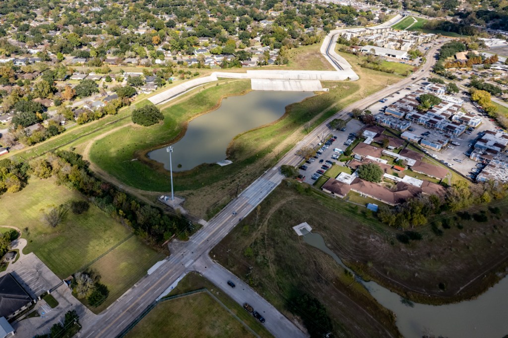
The Harris County Flood Control District (HCFCD) detention basins typically cover several hundred acres and service regions. Willow Water Hole just outside the southwest corner of Loop 610 on a tributary of Brays Bayou is an excellent example.

The 279-acre Willow Waterhole has six compartments. Willow is part of the Brays Bayou Federal Flood Damage Reduction Project (Project Brays), a multi-year, $550 million project that substantially reduces flooding risk in the Brays Bayou watershed. The project is a cooperative effort between the Harris County Flood Control District and the U.S. Army Corps of Engineers. 

Willow Waterhole Detention Basin Complex in SW Houston has six compartments.

Why the Need?

As areas develop, buildings and concrete cover up soil, so stormwater can’t sink into the ground. Water runs off concrete faster than it does from native grasslands. When that water all hits channels, streams and bayous simultaneously from different directions, it exceeds the carrying capacity of the channel. And homes flood.

Many, but not all, new developments use stormwater detention basins to offset that negative effect.

When full, detention basins often resemble lakes. When dry, detention basins look like large excavated open space areas. The Willow Water Hole is normally dry. Yesterday, however, it contained water from recent rains and the low (seasonal rate of evaporation).

Two of the compartments bracket South Willow Drive. See location above.
Note the weir (discussed below) leading to the channel.

Some systems have water in them permanently, so they resemble small lakes. These provide flood storage between the normal surface of the lake and the top of the bank. See the difference in the photograph below.

Willow Water Hole southwestern pond. Note extra capacity between the top of the water and the top of the banks.

Detention? Retention? Which is It?

A detention basin normally has a dry bottom. It holds excess stormwater temporarily.

A retention basin always has a wet bottom. It stores water indefinitely. Retention basis normally have no outlet. Evaporation and infiltration usually keep the lake levels manageable.

The Harris County Flood Control District always builds and uses detention basins. Developers more likely will use retention ponds and market the resulting “lakes” as residential amenities.

HCFCD owns approximately 70 large regional detention basin sites throughout Harris County. They supplement hundreds of smaller developer-built basins. Countywide, these basins hold billions of gallons of stormwater during heavy rainstorms. 

Two northeastern retention ponds within Willow Water Hole complex on either side of South Post Oak Road.

How Water Gets In

Sometimes HCFCD designs stormwater detention basins with a weir (visible in the first and second drone photos above). The weir, or low dam, lets stormwater rising in the channel spill into the detention basin when it reaches a certain height. Other detention basins have no weirs. They are simply open to a channel. In this case, stormwater fills the basin as it rises in the channel.

But there’s also a third alternative for stormwater detention basins, i.e., those not near a channel. Storm sewers and/or sheet flow fill these detention basins. “Big pipes in – little pipes out” is the rule in this instance. The basin gets the water away from streets and homes quickly. Then lets it drain off slowly.

How Water Gets Out

HCFCD typically designs detention basins to drain by gravity, as opposed to using pumps. This lets basins function when power goes out, a frequent occurrence during floods.

In ponds that drain by gravity, depth of the drain (outfall) is dictated by the depth of the receiving channel. The rate at which stormwater drains depends on the stormwater level in the receiving channel. Typically, stormwater drains out of the detention basin after channel levels recede.

Complex engineering calculations determine the volume of stormwater that a detention basin must hold to protect surrounding homes and businesses. That volume, usually measured in acre-feet, determines the width, length and depth of a basin. The amount of time stormwater stays in a basin depends on levels in the receiving channel and how full the basin got. In Harris County, detention time is usually measured in hours, not days.

How the Process Works

Normal Flow

When there is normal flow in a bayou or channel, the detention basin is generally empty.

Initial Storm Effects

Basins begin to fill as bayous or channels rise, or as surrounding developments drain into them through storm sewers.

Capturing the Flow of a Heavy Storm

As water continues to fill the detention basin, it spreads out into the excavated area. Often culverts connect multiple “compartments” within a larger basin, as above.

Detaining the Flow

By holding water in the detention basin, it does not flood homes and businesses downstream.

Draining Detained Water

As the level of the channel recedes, the channel water level drops and lets the basin drain, but only as fast as the channel can handle it.

Back to Normal Flow

With the water level in the channel normal, the basin is once again empty and ready for the next rainstorm.

End Result

Often, HCFCD partners with local groups, such as the Houston Parks Board, to build trails around these ponds that provide a retreat from busy city life. Areas such as Willow Water Hole also provide habitat for birds. People out for a stroll or a jog may think they are in a beautiful park and not even realize the role it plays in reducing flood risk.

Posted by Bob Rehak on 12/2/2021 based on information provided by HCFCD

1556 Days since Hurricane Harvey

Mayor Pro Tem Martin Provides Additional Details on Purchase of Woodridge Village

Houston Mayor Pro Tem Dave Martin issued a press release today that provided additional details about the potential Harris County/City purchase of Woodridge Village.

Unanimous County Vote For Earnest Money Contract

As reported Tuesday evening, Harris County Commissioner’s Court voted unanimously to authorize the Harris County Real Property Division to negotiate an earnest money contract with Figure Four Partners, LTD. The purchase includes two tracts of land containing 267.35 acres located in Montgomery County, which could become the Woodridge Village Stormwater Basin.

The purchase price of $14,019,316.00 is about $5 million below the appraised value of the land. Martin thanks Harris County Judge Lina Hidalgo, Precinct One Commissioner Rodney Ellis, Precinct 2 Commissioner Adrian Garcia, Precinct 3 Commissioner Steve Radack, and Precinct 4 Commissioner Jack Cagle for their support. 

TWDB Loan Application

Said Martin, “This is the first crucial step in completing an inter-local agreement between the City of Houston and Harris County to purchase Woodridge Village.” This vote, coupled with the upcoming announcement from the Texas Water Development Board of the City’s eligibility to apply for a 0% interest loan to help develop the Woodridge Village project, will help reduce future flooding in Kingwood and the Lake Houston region.” 

During May of 2019, as well as Tropical Storm Imelda almost exactly a year ago, Woodridge Village contributed to flooding and heavy sediment deposited in much of northern Kingwood.  Mayor Pro Tem Martin called for the immediate stoppage of the planned development and sale of this site.

End-of-Year Deadline

Martin says he is happy to see the execution of the earnest money contract. It will lock in the purchase price for 120 days. The purchase of the property is contingent upon Harris County Flood Control District (HCFCD) entering in to an interlocal agreement with the City of Houston within 120 days of signing the earnest money contract. 

Last week, the City of Houston Public Works Director, Carol Haddock, submitted a letter of intent to the HCFCD Executive Director, Russ Poppe. It acknowledges the commitment by both parties, City and County, to execute a binding inter-local agreement no later than December 31, 2020. 

“A binding agreement for the proposed transaction can only be evidenced by HCFCD executing a finalized inter-local agreement which will need the approval of Houston City Council” said Martin. Martin also said he “is committed to working with every council office to gain their support of this interlocal agreement, as mutual support of projects to reduce future flooding citywide are key to a successful resiliency plan.” 

The location of the Figure Four Property is suitable for a sub-regional stormwater detention facility, which will help protect affected residents from future intense rainfall events.

Dave Martin, Houston Mayor Pro tem

Consolidation of Three Wastewater Treatment Plants on Woodridge Property

“Additionally, the City has identified a need for approximately 73 acres of the total site to serve as the location for a regional wastewater treatment plant,” says Martin. “This would facilitate consolidation of three wastewater treatment plants in the Kingwood Area.”

Two of these three plants were significantly impacted by flooding during Hurricane Harvey.  

The City would contribute cash for the portion of the site that would house the new wastewater treatment facility.

Land in Lieu of Cash for Floodwater Detention Portion of Property

For the floodwater-detention portion of the property, the City would contribute land in lieu of cash for Harris County Flood Control District flood-risk-reduction projects. 

Construction Funding Details Still to Be Worked Out

Once purchased, the City and District will work together to find additional funding to construct additional stormwater detention on the site to maximize downstream benefits. The Perry Homes/Figure Four Partners property only contains enough detention capacity at the moment to handle about 60% of Atlas 14 requirements. Atlas 14 is NOAA’s attempt to update rainfall precipitation frequency statistics. The need for the update became apparent after four so-called 500-year rains in five years (Tax Day, Memorial Day, Harvey, Imelda).

Despite the recent completion of three additional detention ponds, the Woodridge Village site currently only has about 60% of the detention capacity needed to handle a true 100-year rain (according to Atlas-14 requirements). Photo 9/11/2020.

The City has recently submitted an abridged application to the Texas Water Development Board (TWDB) for a $30 million grant/loan to fund a flood-damage-reduction project on Taylor Gully.

TWDB manages the capital Flood Infrastructure Fund (FIF) created by the 86th legislature in 2019, thanks to Texas State Senator Brandon Creighton and Texas State Representative Dan Huberty. The legislature mutually seeded the FIF program with approximately $790 M, the state has received applications requesting over $2.3 billion to date. Staff recommendations for applications to advance to the formal comprehensive application submittal phase are pending. 

“Ultimately, approval of this earnest money contract is a huge win for the City of Houston and Kingwood residents,” said Martin. “We hope to have more good news once the city has completed its application to the Texas Water Development Board for improvements to Taylor Gully, which will happen later this year.”

Posted by Bob Rehak on 9/17/2020

1115 Days after Hurricane Harvey and 364 since Imelda