Harris County Flood Control District (HCFCD) says that, as of 10/31/22, Sprint Sand and Clay has hauled off 66,094 cubic yards of dirt from Woodridge Village. That means, despite the slowing real estate market, that the company has exceeded its Excavation and Removal contract minimum within nine months of the first year.
Objective of Excavation
The objective of the contract: to get a head start on the removal of up to 500,000 cubic yards of dirt from what will eventually become the sixth stormwater detention basin on the Woodridge Village property. Woodridge forms the headwaters of Taylor Gully.
Community Meeting Will Reveal Findings of Engineering Study
HCFCD is now planning a community meeting to share the results with affected residents before the end of the year.
It’s not clear yet exactly:
How much additional detention Woodridge will need
How much channel widening Taylor Gully will need
Whether any bridges need to be replaced
How upstream improvements will affect residents farther downstream.
The preliminary engineering report should address all those questions.
Photos from September and October
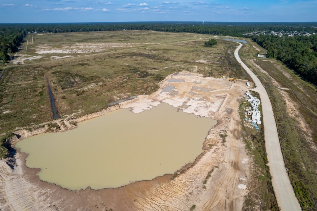
In the meantime, a parade of dump trucks visits the Woodridge site most days to haul off dirt from where the sixth basin will go. The sixth basin could double stormwater detention capacity on the site – if Sprint excavates all 500,000 CY.
Sprint’s contract calls for them to remove a minimum of 60,000 cubic yards per year or 5,000 per month.
The September and October pictures below show how far Sprint has come in the last six weeks.
End of September 2022End of October.Sprint has not gone much farther, but they have gone deeper.
See pictures taken below from the reverse angle. The majority of the work now takes place at the far end.
Extent of excavation on September 24.End of October 2022.
Groundwater appears to be seeping into excavated areas.
HCFCD did not confirm WHY Sprint appears to be digging shallower. Amy Stone, a HCFCD spokesperson, did say however that the site contains multiple types of soil. The volume removed in a particular location may relate to demand for a particular type.
More news about the community meeting and study findings when it becomes available.
Posted by Bob Rehak on November 1, 2022
1890 Days since Hurricane Harvey
https://i0.wp.com/reduceflooding.com/wp-content/uploads/2022/11/20221031-DJI_0038.jpg?fit=1200%2C799&ssl=17991200adminadmin2022-11-01 13:00:172022-11-02 14:38:13Woodridge Village Excavation, Taylor Gully Updates
When Harris County and the City of Houston closed on the purchase of Woodridge Village, flood victims in Elm Grove, North Kingwood Forest and along Taylor Gully were elated. Harris County purchased the land to create a regional floodwater detention basin. That immediately raised questions about what comes next and when?
The first will occur early in the development of the Preliminary Engineering Report (PER). The goals: to inform the community of each project’s purpose and receive community input during preliminary engineering.
A second meeting will occur once the final draft of the preliminary engineering report is complete. Its purpose: to present the results to community.
HCFCD will also communicate with local groups such as homeowner associations and the Kingwood Service Association in regularly scheduled virtual meetings as needed. Those will provide project updates and information about other Flood Control District efforts (e.g., buyouts, maintenance projects, smaller capital projects) in the Kingwood area throughout the PER process.
The Flood Control District will also identify opportunities to participate in regularly scheduled meetings and develop project-specific presentations to convey project information and proposed project features.
First Engineering Firm Already Selected
The engineering firm elected to develop the Preliminary Engineering Report for Taylor Gully improvements, IDCUS, will also consider Woodridge Village within its scope of work. IDCUS will consider what detention volume can be achieved on the Woodridge Village property and how that would affect the Taylor Gully project.
The Flood Control District plans to set up a separate project with a different consultant team to provide the detailed design services for the proposed detention basin.
Role of Rustling Elms Bridge in Flooding to Be Examined
Many residents have observed that the bridge over Taylor Gully at Rustling Elms seems to be a choke point that backs water up into surrounding homes. HCFCD will examine the role of the bridge in flooding. But, said Matt Zeve, Deputy Executive Director of HCFCD, “I cannot guarantee that the recommended plan will include any modifications to Rustling Elms.”
Looking downstream at the Rustling Elms Bridge over Taylor Gully during peak of May 7, 2019 flood. Note how water downstream from the bridge is within banks, but water upstream is overflowing.
The different heights of water above and below the bridge relate its design. See below.
Looking upstream at same bridge at later date, you can see how the twin-culvert design severely restricts flow.
However, retaining more water upstream might eliminate the need to make any costly changes to the bridge. Everything works together. It’s just too early to tell.
Other Changes Being Considered
The Flood Control District is considering a regional stormwater detention basin for the Woodridge Village site. A portion of the property will be owned by the City of Houston for a future wastewater treatment plant.
Looking south across the main portion of Woodridge Village toward homes that flooded twice in 2019. HCFCD will have the southern two thirds of this property (toward the top of the photo) to use for a regional detention basin.
Other amenities could be considered for the site, but would require a partner to construct and maintain those amenities. “The Flood Control District does not design, construct, or maintain amenities such as dog parks, trails, playgrounds, or sports fields,” said Zeve. However, HCFCD expressed a willingness to meet and work with community groups to discuss potential partnerships and make sure that input is included in design considerations.
Atlas 14 Will Form Basis of Design
Perry Homes sized detention ponds currently on the site to meet pre-Atlas-14 requirements. That means their detention capacity will fall about 30-40% short of Atlas-14 requirements. Montgomery County’s Atlas-14 requirements are lower than Harris County’s. When asked about this, Zeve responded, “HCFCD will use Atlas 14 rainfall rates for our designs even if the watershed area is not in Harris County.” That should provide some extra capacity that provides a buffer against additional upstream growth in the watershed.
Could Excavation Start Before Hurricane Season?
The Flood Control District will sometimes starts excavation on sites before final design plans are completed. HCFCD uses this program frequently to get a head start on excavation for large stormwater detention basins. “The District may not have enough time to get that program up and running by June 1, 2021, but we can certainly provide updates on this effort via our website,” said Zeve.
Posted by Bob Rehak on 3/11/2021
1290 Days since Hurricane Harvey
https://i0.wp.com/reduceflooding.com/wp-content/uploads/2019/05/Taylor-Gully-at-Peak-e1728600738227.jpg?fit=1100%2C327&ssl=13271100adminadmin2021-03-11 14:38:492021-03-11 14:38:55What Next for Woodridge Village, Taylor Gully
In early April, the Coastal Water Authority (CWA) quietly finalized the scope of work for engineers working on adding more gates to the Lake Houston Dam. Engineering firm Black & Veatch’s contract was approved. And their work has now begun. Here’s what it involves.
Looking upstream at the Lake Houston Dam. Photo taken 11/4/2019.
The current gates on Lake Houston’s dam have one fifteenth the discharge capacity of Lake Conroe’s – 10,000 cfs vs. 150,000 cfs.
Additional gates could help synchronize the release rates of the two dams and thus reduce flood risk. More/bigger gates could lower the Lake Houston faster in advance of a storm and add width to the spillway during a storm. Both help reduce flooding.
Avoiding Unnecessary Releases
Currently, it takes several days to lower Lake Houston enough to significantly reduce flood risk. During that time, approaching storms can veer away or dissipate. So a conservation angle exists here, too. More gates release water faster. That lets CWA wait until weather-forecast certainty is higher before lowering the lake. And that, in turn, helps avoid unnecessary discharges and conserve water.
18-Month Project Starting from April 8th
The addition of gates is a three-year project broken into two 18-month phases.
Phase 1 involves preliminary design of conceptual alternatives, selecting the “best” based on criteria described below, and permitting.
The clock for Phase 1 started ticking on April 8, 2020, the day Black and Veatch’s contract was approved. Phase 1 should conclude in September 2021.
Phase 2 involves final design and construction. Assuming all goes well, we could have more discharge capacity at the Lake Houston dam by March 2023 at the earliest. However, there will be an evaluation period between the two phases that could push the completion date out further. Also…
Phase 2 Depends on Outcome of Phase 1
One objective of Phase 1 is to prove up the concept, the budget, and the benefit/cost ratio.
Proceeding to construction in Phase 2 will depend on the outcome of Phase 1. In Phase 1, engineers will examine several possible designs to determine the most effective alternative. They will consider flood reduction benefits, downstream impacts, cost, environmental impact, constructibility and more.
Then FEMA will evaluate the benefit/cost ratio of the winning design to ensure it meets or beats initial projections in the grant request.
If it does, FEMA will release money for Phase 2, the final design and construction.
If it doesn’t, the whole project could die.
FEMA does not guarantee Phase 2 funding at this time.
What Happens Now?
The scope of work document reveals who will do what in the next 18 months on the Lake Houston Spillway Improvement Project (LHSIP).
Objective: To relieve upstream flooding by increased discharge capacity that supports pre-releases.
Modifications could include (but are not limited to):
Additional crest gates on or adjacent to the existing dam or…
New, as-yet-unspecified hydraulic structures that provide for releases elsewhere on the embankment
The project will consider both upstream benefits and downstream impacts.
Looking downstream over the Lake Houston Dam in foreground gives you some idea of the courage that it requires to live or work below a dam.
After defining alternatives and constraints, the contractor, Black & Veatch, will analyze the alternatives to quantify and compare costs and benefits of each configuration.
Five Major Tasks in Phase 1
Preliminary engineering involves five major tasks:
Management plans
Hydrology and Hydraulic Modelling
Permitting
Field Investigation
Development of alternative concepts
Let’s look at each.
Management Plans
Black & Veatch will begin Phase 1 by developing project-, quality-, and risk-management plans.
H&H Studies
Hydrology and hydraulics (H&H) studies will evaluate the ability of the various concepts to reduce upstream flooding and downstream impacts. Black & Veatch will develop H&H models that combine both the San Jacinto River and Buffalo Bayou basins to evaluate downstream impacts of any dam.
The combined model will extend all the way to Galveston Bay and evaluate design alternatives for up to nine events:
2-, 10-, 50-, 100-, and 500-year storms
Extreme historic events (e.g. Harvey, Ike or Memorial Day), including at least one with storm-surge effects
A hypothetical Probable Maximum Precipitation event.
The process includes collecting, reviewing, adjusting and validating existing models before performing simulations.
Permitting Gauntlet
To save time, permitting will begin concurrently with design. The permitting schedule is aggressive and may spill over into Phase 2 as details are refined. Permitting includes (but is not limited to) coordination with federal, state and local agencies for:
Environmental Assessment
Environmental Impact Statement
Wetland delineations
Threatened and endangered (T&E) habitat assessment
T&E species-specific surveys
Migratory Bird Treaty Act (MBTA) surveys
Freshwater Mussel survey
Stormwater pollution prevention
Clean Water Act
Flood Plain Construction
The environmental team will also consider:
Topography and Soils Construction Impacts
Land Use
Indirect and Cumulative Impacts
Geology, Hydrology and Drainage
Sediment Quality
Vegetation
Air Quality
Invasive Species
Coastal Zone Management Wildlife and Endangered Species
Essential Fish Habitat
Existing Facilities and Utilities
Noise Quality
Socioeconomics
Traffic and Circulation
Waters of the U.S., including Wetlands
Environmental Justice
Cultural Resources (historical and archaeological)
Recreation
Floodplains
Visual/ Aesthetic Appeal
Water Quality
Hazardous Materials
Field Investigations
Black & Veatch will also conduct site surveys and a geotechnical investigation, complete with borings, to evaluate soil conditions, depth-to-water, permeability, and seepage control.
A bathymetry team will measure water depth and develop contour maps for an area that extends 500 feet upstream from the dam.
Preliminary Engineering/Conceptual Design
Finally, preliminary engineering will develop conceptual layouts and site plans for several alternatives.
This exercise will also evaluate areas of impact, site access and utilities, staging and borrow areas, dewatering extents, existing structure tie-in, general facilities layout, and downstream channel alignment.
These site plans will be used for costing and evaluating the feasibility for each alternative.
Criteria for Choosing Best Alternatives
The engineers will also develop an evaluation matrix that includes, but is not limited to:
Ability to meet project goals
Environmental clearance
Construction costs, including any environmental mitigation
Long-term operation and maintenance costs
Benefit/cost analysis
Risks in design, construction, and operation.
From all the feasible options, engineers will then chose the three best based on:
Cost
Upstream impact
Downstream impact
Environmental impact
Permitting requirements
Constructibility
Timing on Phase 2
Assuming we get to Phase 2, the second 18 months may not start immediately. FEMA will need time to evaluate Phase 1 results. And the CWA will need to develop bid specs, bid the job, select a winner, and develop a contract with a scope of work, just as they did for Phase 1. That could talk several months and push completion well into 2023.
https://i0.wp.com/reduceflooding.com/wp-content/uploads/2020/05/20191104-RJR_4790.jpg?fit=1200%2C800&ssl=18001200adminadmin2020-05-01 12:22:242020-05-01 15:57:06Preliminary Engineering Starts for Adding More Gates to Lake Houston Dam