5/24/26 – What’s wrong with this picture? It shows the confluence of Spring Creek (l) and the San Jacinto West Fork (r).
Confluence of Spring Creek (l) and West Fork on 5/24/26 after several rounds of heavy rain in previous 3 days.
I took it at approximately 3PM today. It has not been retouched. You are looking at the actual color difference in the water coming down the two streams after several days of rain.
However, the heavy rains were almost equally distributed between the two watersheds according to the Harris County Flood Warning System. So, what accounts for the difference? This is important. After all, that’s the drinking water for more than two million people you’re looking at.
20 Square Miles of Sand Mines in a 20 Mile Reach of the River
A quick look at Google Earth Pro will show a huge difference. There is very little (if any) sand mining upstream on the left, but approximately 20 square miles of sand mines in a 20 mile reach of the river upstream on the right.
And in several mines, the West Fork runs right through active or abandoned sand pits, a phenomenon known as “pit capture.”
So, I drove upstream to learn more. Here’s what I saw.
Water flowing out of a former Hallett pit now owned by Riverwalk Porter LLC. The West Fork enters the pit out of frame to the right.See next shot.Where the West Fork now flows into the Riverwalk pit. Hallett mine in background. River used to flow out of frame in the sandy area on the right, which now totally blocks the river.
Farther upstream, but still at the Hallett mine…
The West Fork flows through another captured pit.Northpark Woods subdivision in background. Pond on the left is an active Hallett pit. Pond in center was formerly owned by Hallett’s parent, the Rasmussen Group, but is no longer actively being mined. Despite that, notice discolored water flowing out of center pit into West Fork.The Hallett Mine exposes several square miles of sediment to erosion.
Another source of sediment from the mine is repairs to its dikes. A local fisherman supplied me with this photo taken today. It shows how repairs to a dike near the processing plant are slumping into the river. I originally posted about the repairs several months ago.
Photo taken on 5/24/26 near Hallett processing equipment.
Here’s what that area looks like from the air.
Note loose, unconsolidated sediment dumped into river near center of frame
Externalizing Operational Costs to Taxpayers
The sand-mining industry in Montgomery County helps power growth there. The bulk of the mines are located close to the Harris County line. So Montgomery County gets the benefit. And Harris County gets the cleanup costs in the form of dredging, water treatment, and medical bills.
TCEQ monitors this mine for Nitrate + Nitrite N, total suspended solids, pH, and hazardous metals including Arsenic, Barium, Cadmium, Chromium, Copper, Lead, Manganese, Mercury, Nickel, Selenium, Silver, and Zinc.
Ask your favorite AI program what the health risks of exposure to those chemicals are.
This is what economists call an “externality.” The full cost of providing the sand is not reflected in the bills that purchasers receive. Miners pass their clean up costs on to taxpayers downstream in order to provide an artificially low cost to the actual consumers.
And in my opinion, that’s what’s wrong with the picture.
Posted by Bob Rehak on 5/24/2026
3190 Days since Hurricane Harvey
The thoughts expressed in this post represent opinions on matters of public concern and safety. They are protected by the First Amendment of the US Constitution and the Anti-SLAPP Statute of the Great State of Texas.
https://i0.wp.com/reduceflooding.com/wp-content/uploads/2026/05/DJI_20260524145751_0210_D.jpg?fit=1100%2C619&ssl=16191100adminadmin2026-05-24 19:21:342026-05-25 09:33:44What’s Wrong with This Picture?
8/14/25 – A State of Texas lawsuit against the Triple PG sand mine that began in 2019 will now be tried, at the earliest, in 2026. Meanwhile problems at the mine have gotten worse. Breaches in their dikes that triggered the lawsuit have recurred. And five pipelines carrying highly volatile liquids (HVL) are now exposed and suspended over another breach.
Trial Date Set for Feb. 2026
According to the fourth revised scheduling order issued by a Travis County district court, the lawsuit brought by the State of Texas against the Triple PG sand mine in Porter will now go to a jury no earlier than February 2026.
The State first sued Triple PG in 2019 for mining sand in a pit whose dikes had been breached in at least two places. White Oak Creek was flowing through an area being actively mined and then out through Caney Creek into the headwaters of Lake Houston, which supplies drinking water for more than 2 million people.
The judge quickly issued an injunction against the mine’s owner. Mining briefly stopped while miners repaired the dikes. But the dikes failed again. And the mine briefly became an issue in a Houston mayoral election when Tony Buzbee visited the breach for a photo op in May 2019.
Tony Buzbee (plaid shirt) visited Triple PG breach into Caney Creek with camera crew in May 2019 during mayoral campaign.
On the legal front, the mine’s owner, a cardiologist from Nacogdoches, named Prabhakar R. Guniganti, transferred ownership of the mine through a series of shell companies and trust funds that he and his family controlled. This forced the attorney general’s office to sue one entity after another and name the cardiologist individually as a defendant.
In August and September this year, the parties will designate their expert witnesses.
During October and November, they will complete discovery.
In December, they will challenge each other’s expert witnesses and file remaining unheard motions.
In January, they will exchange witness and exhibit lists.
And the Jury Trial will begin on February 9, 2026.
However, the possibility exists that this could slip again as it has at least twice before. The judge originally scheduled this case for trial on October 10, 2023, and October 28, 2024.
General Reasons for Delays
Aside from specific legal maneuverings in this case, lawsuits in general can drag on for years. Many moving parts must align. And each step can take months or even longer. The main causes include:
1. Pre-trial Procedures Can Be Slow
Discovery – Both sides gather and exchange evidence, which can involve reviewing thousands of documents, deposing witnesses, and fighting over what’s admissible.
Motions and Hearings – Lawyers may file motions to dismiss, suppress evidence, or get summary judgment. Each motion needs time for responses and court rulings.
Scheduling Conflicts – Courts juggle many cases, and attorneys may have other trials or deadlines.
2. Complexity of the Case
Many Issues – Multi-defendant cases or lawsuits involving technical subjects (e.g., environmental law, patents) require more experts, more evidence, and more coordination.
Specialized Evidence – Expert reports, forensic analysis, or financial audits can take months to produce.
3. Negotiation and Settlement Efforts
Even if both sides want to settle, negotiations can stall while parties evaluate risk, await rulings on key motions, or try mediation.
4. Appeals and Interlocutory Delays
If a court rules on an important issue before trial, one side might appeal immediately. This “pause” can last a year or more before the trial even resumes.
5. Strategic Delays
Parties may deliberately slow the process to pressure the other side—by increasing costs, waiting for evidence to weaken, or banking on a change in law or circumstance.
6. Court Backlogs
In busy jurisdictions, there can be long waits simply for your turn on the docket—especially after events like the COVID-19 pandemic, which created major case backlogs.
Dikes Open and Pipelines Exposed
In July, mining continued with the dikes wide open again.
The U.S. Mine Safety and Health Administration regulation §56.20010 regarding retaining dams specifies that “If failure of a water or silt retaining dam will create a hazard, it shall be of substantial construction and inspected at regular intervals.”
TCEQ also has requirements for constructing dikes and levees. Note the paragraph on page 2 about structural integrity. “Construction must be based upon sound engineering principles. Structural integrity must withstand any waters which the levee or other improvement is intended to restrain or carry, considering all topographic features, including existing levees.”
Pipeline Issues Now Added to Complaint
Breaches aren’t the only issue at the Triple PG mine (now operated under the name Texas Fracsand). The daredevils operating the mine have exposed five pipelines carrying highly volatile liquids.
Triple PG Breaches and Exposed Pipelines on July 24, 2025
I alerted the Texas Commission on Environmental Quality after discovering this, but have not yet heard of the outcome of their investigation.
When went back today to see if the operator had addressed either the breaches or the pipeline issues, I found no changes.
The breeches were still wide open and the pipelines unprotected.
Pray that we don’t see any more delays in the jury trial.
Posted by Bob Rehak on 8/14/25
2907 Days since Hurricane Harvey
The thoughts expressed in this post represent opinions on matters of public concern and safety. They are protected by the First Amendment of the US Constitution and the Anti-SLAPP Statute of the Great State of Texas.
https://i0.wp.com/reduceflooding.com/wp-content/uploads/2025/08/20250814-DJI_20250814160312_0143_D-2.jpg?fit=1100%2C619&ssl=16191100adminadmin2025-08-14 17:40:112025-08-14 17:42:04Triple PG Sand-Mine Lawsuit Slides to Year 7 as Problems Get Worse
1/13/25 – The Texas Commission on Environmental Quality has proposed new Best Management Practices (BMPs) for mining in response to a mandate from the 2023 session of the Texas Legislature. However, in my opinion, the recommended BMPs will do little to nothing to help control sediment pollution from mines in the Lake Houston Area.
The BMPs feel like little more than a half-hearted attempt on the part of a reluctant regulator to create the illusion of environmental protection.
You can find the proposed BMPs at this page on the TCEQ website. You may submit comments on them electronically. To be considered, TCEQ must receive your input by 11:59 p.m. on January 24, 2025. Your email should reference “APO BMP List Proposal.”
Please let the TCEQ know what you think even if you disagree with me.
Notable Omissions
The TCEQ’s recommended BMPs do not really address the biggest mining issues we have in the upper San Jacinto watershed.
I urge you to urge TCEQ to develop BMPs that address:
Discharge of sediment-laden water
Pit capture (when a river starts flowing through a mine)
Periodic flooding.
The proposed BMPs do not cover these issues at all.
The final report of a TCEQ investigation into a West Fork pit capture last year didn’t even mention the phrase. Do they not consider it a problem? I sure wish the TCEQ could enlighten us on this issue. I documented seven instances of pit capture in the Lake Houston watershed last year alone. There may have been more; many mines are in remote, difficult-to-access locations.
Sediment Pollution Reduces Water Quality, Increases Flood Risk
All three of the bullet points above add up to a big problem called “sediment pollution.” Dredging costs for the City of Houston and Army Corps approached $200 million dollars as of October 2023. Better BMPs would likely have reduced or delayed that expenditure of public funds.
At an October 2023 town hall meeting in Kingwood, Mayor Pro Tem Dave Martin presented this summary showing dredging costs totaling $186 million.
But those costs paled in comparison to the damages to 13,000 homes and businesses that flooded in the Lake Houston Area behind giant sand bars that formed sediment dams at the mouths of the East and West Forks of the San Jacinto.
Nor do the costs reflect extra water filtration at the City’s Northeast Water Purification plant.
To be fair, nature causes some erosion. The question is whether local mining practices accelerate it.
Photos of Sediment Pollution Related to Discharges, Pit Capture and Flooding
See the pictures below. I will submit these as part of my comments on the draft BMPs. Feel free to submit them as part of yours, too.
Confluence West Fork and Spring Creek near US59 Bridge. This is a frequent sight. Twenty square miles of mines are upstream on the right in a 20-mile reach of the river.San Jacinto East Fork capturing a mine in Plum Grove.Effluent from the Hallett Mine settling pond (white in upper right) on San Jacinto West Fork escaping into adjacent property owned by others.Close up of same effluent from same pondDike of abandoned Williams Brothers Mine (upper right) eroded by the San Jacinto West Fork (lower left) about to give way……was taken out by flooding from Hurricane Beryl shortly after I took the photo above this one.
Hallett sold the San Jacinto West Fork sand pit below to a real estate developer. Within months, the river captured the pit.
West Fork flows into the pit at the north end……and flows out at the south end.The pit in question is to the right of the S-turn in the river (middle). Here you can see both the entry (lower right) and exit (upper right) breaches in the dikes.
River Speed During Floods High Enough to Stir Up and Carry Even Largest Particles of Sand
Now, let’s discuss the speed of floodwaters and whether it’s sufficient to entrain sand in pits and carry it downstream.
Flood inundated both sides of the West Fork during May 2024.My drone measured logs floating through the captured pit at 5 MPH, more than fast enough to scoop up and carry off the largest grains of sand and other sediment.See below.Industry-standard graph shows the speed necessary to erode, transport and deposit sand/sediment of different particle sizes. Blue line indicates measured speed of water. Red indicates range of typical sand sizes.Another West Fork pit capture at the Hallett Mine after floodwaters receded. Notice how natural channel of the river has been virtually cut off.Effluent from the Hallett Mine (upstream in upper right) polluting the West Fork at the Northpark/Oakhurst Ditch (middle foreground). Water flows right to left.Reverse angle shows proximity of pollution to homes.Same ditch blocked by sand increases flood risk for those homeowners.Farther downstream, the Kingwood Diversion Ditch (top middle) also became blocked by sediment. A Harris County Flood Control District study found that the Diversion Ditch was one of the two most dangerous flooding problems in Kingwood.Broken dike at the Triple PG sand mine in Porter. Industrial waste water is flowing out of the mine into White Oak Creek which joins Caney Creek and the San Jacinto East Fork before flowing into Lake Houston.
Horrifying! Aren’t they? The truly horrifying part is that I have thousands of similar shots. These are not isolated instances.
This is THE biggest environmental problem in the Lake Houston Area. We have industrial waste polluting the drinking water supply for 2 million people and the TCEQ BMPs don’t even address the problem.
Don’t forget to reference “APO BMP List Proposal” when you submit the web form. Greater setbacks of mines from rivers could solve all the problems discussed above.
Posted by Bob Rehak on 1/13/25
2694 Days since Hurricane Harvey
The thoughts expressed in this post represent opinions on matters of public concern and safety. They are protected by the First Amendment of the US Constitution and the Anti-SLAPP Statute of the Great State of Texas.
https://i0.wp.com/reduceflooding.com/wp-content/uploads/2025/01/20240504-DJI_20240504164238_0406_D.jpg?fit=1100%2C619&ssl=16191100adminadmin2025-01-13 17:53:172025-01-13 19:12:07Better Sand-Mining BMPs Needed to Control Sediment Pollution
12/13/24 – Proposed new Texas Commission on Environmental Quality (TCEQ) Best Management Practices (BMPs) for sand mines ignore what miners are supposed to do in the case of pit captures. “Pit capture” happens when a river breaks through the dikes of a sand mine. It can have serious consequences including, but not limited to:
Increased erosion and river instability
Altered hydrology
Water quality degradation
Habitat loss and ecosystem disruption
Infrastructure risks
Channel realignment
Economic impacts (cost of mitigation)
Identifying Pit-Capture Pros and Cons
In some circumstances, pit capture can also produce benefits. The balance between benefits and risks depends on the specific geomorphological and ecological context of the river and the sand mine pit. To maximize benefits while mitigating risks, scientists recommend:
Performing a hydrological and ecological assessment before and after capture.
Using adaptive management strategies to guide the development of the captured pit.
Integrating the site into regional plans for flood control, habitat creation, or recreation.
However, the new TCEQ sand mine BMPs mention no such studies, despite the fact that at least six pits were captured on the East and West Forks of the San Jacinto during floods this year. Plus, consider this. The City is getting ready to spend another $34 million to dredge another million cubic yards of sand from the confluence of the two forks.
Instead, the new TCEQ BMPs emphasize concepts under headings such as “Be a Good Neighbor,” “Practice Good Housekeeping,” and “Select Appropriate Equipment.” This is stuff most guys learned in a middle school shop class. Under “Good Housekeeping,” one recommendation urges miners to adequately maintain sanitary facilities. But they forgot the “Wash hands after using a port-a-potty” requirement.
My overwhelming impression after reading the new BMPs was a yawn. Why bother?
The new BMPs are more notable for what they don’t include than what they do include.
And they don’t include anything about the B-52 sized elephant in the broom closet – pit capture.
River now cuts through Hallett Pit on West Fork and has abandoned its original channel (right).Pit containing wastewater now has a more direct route to river when it breaches. Note repair by maintenance road.The pit above is just one of many at the Hallett West Fork Mine which spans several square miles.
I discovered the pit capture above in June of this year. It likely occurred in the May flood. And Hallett has done nothing to mitigate it since.
Perhaps they and the TCEQ feel the benefits outweigh the consequences. But of course, they aren’t footing the $34 million dredging bill.
In August of this year, TCEQ issued a report on another pit capture slightly downstream from here. It didn’t mention this pit even though it was open at the time and multiple people filed complaints. Nor did it mention the term “pit capture.” And the report made several other mistakes. For instance, Hallett claimed the expert witness TCEQ identified works for them, the but the TCEQ listed the employee as working for a Hallett competitor. No wonder the Texas Sunset Commission called TCEQ a reluctant regulator.
Leave a Public Comment
So what’s a mere citizen who enjoys clean water to do?
The TCEQ is soliciting public comment on their new BMPs for sand mines. I know what my comment will be about. If you wish to leave a public comment:
Feedback or comment must be provided to Jess Robinson, MC 175, Office of Legal Services, Texas Commission on Environmental Quality, P.O. Box 13087, Austin, Texas 78711-3087. Comments may also be submitted electronically. To be considered for this project, input must be received by 11:59 p.m. on January 24, 2025, and should reference “APO BMP List Proposal.”
8/6/24 – During Beryl in July, the San Jacinto West Fork continued to run through at least three abandoned sand pits. Mining companies still own two. A third has been sold to a residential developer for unknown purposes.
The river captured the pits earlier this year. “River capture” is a term used by geologists when floodwater breaks through a dike on one side of a pit and then bursts out the opposite site. That effectively reroutes the river. The phenomenon usually takes place in pits on a point bar and shortens the distance water must travel around them.
Sold by Hallett to Riverwalk Porter LLC
Hallett sold a 200-acre pit on the west side of the San Jacinto West Fork to Riverwalk Porter LLC shortly before the January floods this year. It was great timing for Hallett; not so great for the developer. See below.
West Fork, upper left, enters a 200-acre pit (left) that Hallett sold to Riverwalk Porter LLC shortly before the pit capture.Note how the normal riverbed is now blocked by sand. 8/6/24.At the south end of the same pit, the river re-enters its normal channel.8/6/24.
If Riverwalk Porter LLC planned to use this pit for stormwater detention, that will no longer work. They would be pumping water directly into the river.
Second Pit Still Owned by Hallett
A little farther north, the river cuts through another pit. Hallett still owns this one. The southern end of this pit (bottom of frame below) was left open for years until the Texas Commission on Environmental Quality (TCEQ) made Hallett fix it.
Now it’s open again…but on two sides. And the TCEQ has not yet taken action. I first observed this opening after May floods.’
Looking North. West Fork now cuts straight through the pit rather than going around it via its normal channel.8/6/24.Closer shot of bypassed channel at same pit.8/6/24.
Williams Brother Pit
Just south of White Sands Drive in Porter, Williams Brothers abandoned a pit after Harvey. The company still owns the property. However they show no signs of re-establishing an eroded dike.
A narrow berm used to seal the pit off from the river at the top of the frame. The berm eroded during January floods then disappeared in May floods this year.
With the river now flowing into the mine, it is starting to erode a channel out of the mine.
Williams Brothers Mine after Beryl. Photo taken 7/9/24. River flows toward foreground.
In fairness, when the river is lower, the channel in the foreground does not yet convey water all the way back to the river.
Abandoned Pits Becoming Bigger Problem
At least four other companies have abandoned pits on the West Fork in recent years that represent potential issues:
I’ve been talking lately to residents neighboring these facilities. They worry about flooding related to the mines and how that can undermine their property values.
One resident that I interviewed today talked about growing up on the river before Lake Conroe, sand mining and his property flooding. He talked about clear water, abundant fish and plentiful wildlife.
I’ve been researching best practices for sand-mine abandonment and have some thoughts that I will share on the subject in coming days. I’m not sure we can get back to the way it was in the 1960s, but we can definitely do better. Check back in the coming days.
Posted by Bob Rehak on 8/6/2024
2534 Days since Hurricane Harvey and 29 since Beryl
The thoughts expressed in this post represent opinions on matters of public concern and safety. They are protected by the First Amendment of the US Constitution and the Anti-SLAPP Statute of the Great State of Texas.
https://i0.wp.com/reduceflooding.com/wp-content/uploads/2024/08/20240806-DJI_20240806112047_0506_D.jpg?fit=1100%2C619&ssl=16191100adminadmin2024-08-06 21:32:422024-08-06 21:39:12West Fork Still Running Through Sand Pits
The San Jacinto West Fork has become totally blocked by sediment at the Hallett Mine in Porter and rerouted itself through the giant sand mine.
The old river channel has been sealed off by sediment. And the river now enters and exits one of the mine’s largest pits through large breaches in what used to be dikes. See below.
White oval shows location of blockage. Blue line shows old route of river. Red lines show detours through sand pit.
More than Normal Erosion
Rivers always move during floods through erosion. But this represents a far larger than normal amount of movement through a process called pit capture.
The river now runs through the Hallett pit instead of following its normal curving channel.
See photos below.
The loss of the dikes is likely the result of the SJRA releasing 71,000 cubic feet per second from Lake Conroe during the peak of the recent flood. That was the second largest release in the history of the SJRA.
Pictures taken just before the peak of the flood show the river already overtopping the pit’s dike. Dikes like walls that separate the river from the mine’s pits. They keep industrial wastewater out of your drinking water.
Weak Sand Mining Regulations Brought This On
Two other contributing factors are the depth of the pit compared to the river and the width of the dike.
The deeper the pit (compared to the river), the less stable the dike.
The narrower the dike, the weaker it is.
Until recently, Texas was one of the few states (if not the only one) that had no minimum setbacks of mines from rivers. Bill McCabe of the Lake Houston Area Flood Prevention Initiative was instrumental in lobbying for greater setbacks. The TCEQ adopted them in 2021, but this pit predated the new regulation. And the TCEQ did not enforce the regulation in this case.
In fact, this pit was open on its southern end since January. That breach was already expanding before the recent flood.
Pictures Taken Before and After Flood Show Pit Capture
Pictures taken during and after the flood show the impact.
Hallett Mine San Jacinto West Fork on May 3, near peak of recent flood.Same area photographed on May 11, 2024. Break in dike is circled in red.
Following the river around to the right, you can see how much sand the river laid down. This likely happened when the volume of water moving through the channel decreased as the velocity decreased, allowing suspended sediment to drop out of suspension.
The river which flows right to left, used to flow toward the bottom left. But now it flows into the pit (upper left).Closer shot showing the river being diverted into piton the left.
This video shows the height of the sand deposited in the river bed when the river started flowing to the pit instead of following its normal channel.
Video courtesy of a fisherman, Jody Binnion. Listen to his narration.This shot also gives you some idea of the height of the sand now blocking the river.Farther upriver but looking downriver, you can see how the river has been diverted. Note how narrow the dike is/was as it approaches the point of failure.Note the ripples on the water flowing into the pit.At the far southern end of the pond, the water exits back into the river through this breach that opened up in the January flood.Between the new entrance and exit from the pond, the Northpark ditch enters the river from Oakhurst and Northpark Woods.
Impacts Associated with Pit Capture
Without a river to remove sand from the confluence with the ditch, more and more sediment will likely build up here.
In regard to the last point, sand mining also frequently stirs up heavy metals such as lead and cadmium, which have been documented in academic literature. However, I have no evidence that such chemicals are coming from the Hallett Mine.
This river, which now flows through the Hallett pit, flows into Lake Houston. And Lake Houston is the source of drinking water for more than 2 million people.
Posted by Bob Rehak on May 11, 2024
2448 Days since Hurricane Harvey
The thoughts expressed in this post represent opinions on matters of public concern and safety. They are protected by the First Amendment of the US Constitution and the Anti-SLAPP Statute of the Great State of Texas.
https://i0.wp.com/reduceflooding.com/wp-content/uploads/2024/05/20240511-DJI_20240511084429_0574_D.jpg?fit=1100%2C619&ssl=16191100adminadmin2024-05-11 11:28:382024-05-14 17:08:58San Jacinto West Fork Reroutes Itself Through Giant Hallett Mine
The sign outside the abandoned Texas Concrete Sand and Gravel Mine in Plum Grove tells readers that an RV resort is coming soon. They might want to rethink that concept. Yesterday, rampaging floodwaters destroyed most of the mine except for a small area near the entry on FM1010.
Classic Example of Pit Capture
The East Fork rerouted itself right through the heart of the mine, sweeping away almost everything in its path. The river swelled to more than half a mile wide and ruptured dikes in at least four places when the river rose 10 feet in 24-hours.
The East Fork at this location rose 15 feet in three days, 10 of those in one day.
Normal course of river is red line on west side of mine. During flood, the river broke through the dike on the north side. Then floodwater filled the mine like a water balloon which burst in multiple places on the south side. Water now follows the yellow line.
This is a classic example of what geologists call pit or river capture. The East Fork entered the northern side of the mine and exited at multiple points on the south. Current coming out of the mine exceeded that in the river itself, carrying mud and muck downstream.
Flooding Based on Less than 10-Year Rain
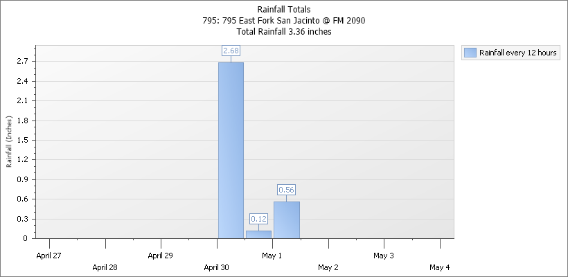
The gage at this location indicated Plum Grove received only 3.36 inches of rain over a three-day period. However, up to 8 inches fell upstream from here, primarily during a two-day period. Jeff Lindner, Harris County’s meteorologist characterized the rains that produced the flood as, “Generally less than a 10-year event for the 48-hour time period.”
Pictures Taken on 5/3/2021
I took all of the shots below on 5/3/2021, three days after the major portion of the rain fell on April 30.
Looking north at the northernmost portion of the mine. The river appears to have entered the mine in this area.Note the dike in the far distance that’s not visible in the tree-line on the left.
Wider shot, still looking north toward entry point shows white water ripping through mine.
Looking south, you can see that the water in the mine is now higher and faster than the water in the river to the right.
Still looking south toward FM2090, now the only way in and out of Plum Grove. FM1485 is closed due to high water and FM1010 was washed out during Harvey by runoff from Colony Ridge to the southeast.
Looking north across FM2090. Where the water exits the mine, you can see that the force of the main flow is now misaligned with the bridge opening.
The width of the mine is now the width of the river…plus the river.Only the entry of the mine at the upper right remains above water at this time.
Looking east from over FM2090.
Danger of 2090 Washout in Next Big Flood?
Unless someone reroutes the river back to its original course and fixes the dikes, the current through the mine will continue to erode the banks of the roadway at the top of the image above.
These images dramatize the need for real sand-mining reform in Texas. There’s some evidence that Imelda did the same thing to this mine two years ago. But the TCEQ forced the company to repair the dikes. Now that the miners are gone, who will do that?
Plum Grove was lucky that upstream rains only amounted to a ten-year event. A larger storm could have cut the City and Colony Ridge off from the only viable evacuation route. More than 20,000 people would have been affected.
Posted by Bob Rehak on 5/3/2021
1343 Days since Hurricane Harvey and 592 since Imelda
The thoughts expressed in this post represent opinions on matters of public concern and safety. They are protected by the First Amendment of the US Constitution and the Anti-SLAPP Statute of the Great State of Texas.
https://i0.wp.com/reduceflooding.com/wp-content/uploads/2021/05/20210503-DJI_0661.jpg?fit=1200%2C900&ssl=19001200adminadmin2021-05-03 15:45:402021-05-04 07:53:21Rampaging East Fork Floodwaters Cut New Path Through Plum Grove Sand Mine
This story illustrates on of the dangers of pit capture in sand mining. During the peak of Imelda, 42,000 cubic feet of floodwater per second came down Caney Creek. However, early the morning of September 19th, residents south of the Triple PG Sand Mine on Hueni Road in Porter started seeing water coming from the mine before it came up from the creek.
Escaping with Only a Minute to Spare
They started evacuating their families and animals. One Walden Woods resident told me that the water came up so fast, it covered an entire SUV within an hour. Another told me that had she waited one more minute to evacuate, she and her family would have had no way out. The force of the rushing water undermined the house and garage of a third. Farther south of the mine, residents of Dogwood Lane, Woodstream Village, Dunnam Road, and Riverchase felt the same panic.
Caney Creek Captures Triple PG Sand Pits
So what happened? A review of aerial photographs below taken on 10.2.19, almost two weeks after Imelda, showed a massive breach in the northern dike of the mine. Erosion patterns suggest the water then rushed through the mine in a north to south direction.
Trees laid down in a southerly direction at the entry point
Sand waves orient along the north-to-south direction of flow
East/west roads separating the ponds were blown out, by water flowing north to south
The mines main stockpile shows massive erosion along its western edge in a north-to-south direction
Sand is piled up against the mine’s main building along the northern side only (where the water came from)
Photo Tour of the Aftermath
All the photographic evidence suggests a classic case of pit capture. Peach Creek joins Caney Creek just north of this entry point.
Where water entered the mine from the north. Looking northwest from inside the mine and past the northern dike. Note the trees pushed into the mine by the force of the water, indicated the direction of flow.Reverse shot. Looking south into the Triple PG Sand Mine.A closer view of the same scene shows clear evidence of erosion within the mine from rushing floodwaters. The water came from directly behind the camera position. The road in the middle was blown out, but reconstructed by the time I shot this photo two weeks after Imelda. The TCEQ said they could not safely reach this part of the mine because of damaged roads.
You can see from the shot above that water barreled through this mine as if shot from a water cannon.
Close up of repairs to damaged road. Looking southwest. Sand patterns show water moving north to south. Note the sand pushed up against the north-facing back of this building.The eastern side of this stockpile was eroded from the bottom by water side-swiping it from a north-to-south direction.
No Effective Dike at Southern End of Mine
There really is no dike at the southern end of the pit, just a road around the perimeter. The ground level in the neighborhood to the south is virtually even with the level of the road. After water flowed through the pit, it flowed through neighborhood(s) to the south and damaged homes. It’s easy to see the damage immediately south of the pit and imagine the pit capture as the cause of the damage. The damage faces the mine, not Caney Creek to the east.
Floodwaters from the Triple PG mine partially knocked this home off its foundation. The owner had to jack it up and re-level it. The back of the house faces the mine and is not more than a hundred feet from it.The same homeowner’s garage. Floodwaters from the mine scoured under it. Again, the back of the garage faces the mine and is not more than a 100 feet from it.
Reasons for Pit Capture
What is pit capture? It’s when a river or stream cuts through the pit of a nearby sand/gravel mine instead of following its normal course.
How does it happen? Water starts to overtop or penetrate the dike. It creates a fissure that rapidly widens and opens a hole. Pretty soon the dike collapses and the water rushes in. The water moves from areas of high pressure and elevation to areas of low pressure and elevation. After the water moves into into the pit, it fills the pit up and needs to find a way out on the other end. Like a water ballon attached to a faucet, sooner or later dikes on the other side burst.
Why does this happen?
The mine was built in the floodway of Caney Creek on a point bar
Dikes made out of sand could not withstand the force of the water
Dikes had previously failed in the same places and left “weak points”
When the water came up, it took the path of least resistance
Texas has no minimum setbacks from rivers for mines
Texas enforces no best management practices for mines
Potential fines could reach well past a million dollars. That raises the question, “What can be done with this mine to protect residents below the mine and to protect the City of Houston’s water supply?”
Over the years, Triple PG’s owners have removed 800 acres of forest and an unknown volume of sand from the mine. The risk of pit capture is greatest were mines are deeper than the adjacent river bed and close to the river/stream. Both conditions apply in this case.
The dike between Caney Creek and the Triple PG pit is a narrow strip of unvegetated dirt, just wide enough to support a vehicle…and not compacted very well as you can see below.
This shows repairs to an exit breach to Caney Creek farther south. No geotextile fabrics or rip rap are holding the repair together. Photo courtesy of Josh Alberson. Taken 11.2.2019.This closer shot shows the same breach filled with sand and clay. You can see how flimsy the repair is. The uncompacted and unprotected soil is already eroding after two inches of rain last week.Photo courtesy of Josh Alberson. Taken on 11.2.2019.
If the courts should shut this mine down, sealing it off permanently will be difficult and costly.
Posted by Bob Rehak on 11.3.2019 with images from Josh Alberson
796 Days since Hurricane Harvey and 45 since Imelda
The thoughts in this post reflect my opinions on matters of public concern and safety. They are protected by the First Amendment of the US Constitution and the Anti-SLAPP Statute of the Great State of Texas.
https://i0.wp.com/reduceflooding.com/wp-content/uploads/2019/11/Triple-PG-Mine-Looking-South-10.2.19.jpg?fit=1500%2C1000&ssl=110001500adminadmin2019-11-02 20:10:422019-11-02 20:10:53Pit Capture on Caney Creek: What Happens When A Sand Mine Builds Flimsy Dikes in Floodways
Steady northward migration of the San Jacinto West Fork could threaten the proposed new high-rise Kingwood Marina development – within the lifetime of many residents.
An analysis of satellite and aerial imagery in Google Earth shows that the river channel has shifted 758 feet north in 40 years – almost 20 feet per year – toward the site of proposed 25-50 story high rises. The proposed Kingwood Marina site is on the cutbank side of the West Fork. And the West Fork is definitely cutting.
Measuring River Migration Rate
These three images tell the story.
The white line shows where the original north shore of the river was in 1978. Image also shows location of proposed high rises relative to the river as it existed then. This shows the river in 2017 after Harvey. The line shows the original location of the north shore in 1978. The river has shifted north by its entire width. The measuring tool in Google Earth shows that the shift was 758 feet (length of the yellow line).
The migration of the river toward the high rises should continue. The river appears to be moving back toward one of its old meanders. The developer plans to build the high-rises in the old river bed. That’s a dangerous practice, because during floods, as residents all over Harris County discovered after Harvey, water seeks to return to old channels.
Floodway Shifting, Too
As the river moves closer to the high-rises, so will the floodway. Right now, the high-rises are built on the edge of the floodway that was mapped after Tropical Storm Allison in 2001. However, I believe that upstream development, river migration, and sedimentation are causing the floodway to expand and shift north. If current plans are approved “as is,” structures, people’s lives, and investor’s money will all be at risk.
Already at Greater Risk than Town Center
Harvey inundated Kingwood’s Town Center area. That’s a mile further from the river and on higher ground. About a year and a half later, approximately 25% of the businesses in Town Center still have not returned. That would certainly affect the economics of this development if it ever floods.
The proposed high rise development would sit on the edge of the cross-hatched area which represents the old floodway. These floods zones became effective in 2007, but are in the process of being updated in light of new data from three so-called 500-year storms in 2015, 2016 and 2017.
50 Years or Bust
At the current rate of northward migration, the river could reach the marina in about 50 years; it’s currently about a 1000 feet away. If the river “captures” the marina (just as it captures sand pits), we could expect to see a rapid shift in river migration toward the high rises. See the demonstration in the video below.
How rivers can suddenly jump when they get near big open areas like sand pits…or a marina.
Of course, before that happened, someone would try to prevent it. The owners would push to “shore up” the development with bulkheads or levees.
Futile Struggle to Combat Nature
Bulkheads didn’t work very well for these people on Marina Drive in Forest Cove.
Empty townhomes stand a mute witness to the destructive power of 240,000 CFS/second.
Levees have their own set of problems. And anyway, how do you put a level around a marina? Seems like building this close to the river is just asking for trouble.
Planned Construction Level Likely to Flood Every 4-10 Years
The developer wants to build the foundations up to 57 feet. That’s asking for trouble, too.
If you go back and analyze the crest data for the West Fork for the last 90 years, you will see that the river has crested higher than 57 feet nine times – once a decade. But you will also see that it has crested higher than 57 feet six times in the 25 years since 1994 – about once every FOUR YEARS!
Rivers! Look pretty. Get ugly.
Sometimes rivers remind me of that classic 1983 teen flick called War Games staring Mathew Broderick and Ally Sheedy. The duo hacks into a Department of Defense Computer and starts playing what they think is a game. It’s called “Global Thermonuclear War.” They quickly discover it isn’t a game; they’ve triggered the real thing. In the end, they discover that “the only winning move is not to play.”
That’s certainly the case with the West Fork.
As always, these are my opinions on matters of public policy. They are protected by the First Amendment of the United States Constitution and the Anti-SLAPP statute of the Great State of Texas.
Posted by Bob Rehak on 1/26/19
515 Days since Hurricane Harvey
https://i0.wp.com/reduceflooding.com/wp-content/uploads/2019/01/Highlight.jpg?fit=1500%2C991&ssl=19911500adminadmin2019-01-26 19:55:462019-01-27 02:34:52West Fork Migrating Toward Proposed High-Rise Marina Project at 20 Feet Per Year
In the next two months, I expect to see legislation filed that will strengthen regulations on sand mining. Hopefully, legislation will prevent dangerous practices by the mining industry that have put residents at risk in the past.
Perhaps we can compromise on legislation that lets miners exercise their property rights without harming the property rights of others…or their incomes, safety, and families.
This is another post designed to raise awareness of sand mining problems and how other states have solved them. One of the main problems with sand mining in Texas: virtually all miners locate their mines in floodways. That almost guarantees a phenomenon called pit (or river) capture. Washington State has discovered the following about pit capture.
“Regardless of the best planning and intentions, impacts of flood-plain mining may simply be delayed until the river is captured by the … pit,” they say. “While capture may not occur in the next 100-year flood event, it is likely to occur in the future as development and consequent flood magnitude increase. In the long term, stream capture by (sand and) gravel pits is a near certainty.”
Consequences of Pit Capture
The paper cites more than three dozen examples of pit capture. Consequences include:
Lowering the river bed upstream and downstream of mining operations
River bed erosion and (or) channel incision
Bank erosion and collapse
Undercutting of levees, roads, bridge supports, pipelines, utility towers and other structures
This short YouTube video may help you visualize how this process works. A company called Little River made it with funding from the EPA and State of Missouri. Little River specializes in table-top, tank experiments for science classes. This video shows how pit capture happens and how erosion results.
Depending on the area and depth of the pit, and sediment volume carried by the river, it could take “millennia” to restore the natural environment after pit capture.
Operators’ attempts to prevent pit/river capture by armoring dikes and channelizing rivers often accelerate floodwaters and increase erosion downstream, say the authors (page 13 and figure 17) .
Cures for Pit Capture
The Washington State Department of Ecology Shoreline Management Handbook recommends locating mining activities “outside the shoreline jurisdiction.” They recommend 200 ft. from the floodway or off the 100-year flood plain. The latter coresponds to Texas regulations for the John Graves Scenic Riverway District on the Brazos River.
Immediate Reclamation for Each Segment
The Washington State Department of Natural Resources administers their Surface Mine Reclamation Act (RCW 78.44). It generally requires reclaiming mines immediately after each segment is mined. The 1993 revision of this law requires that most mines in flood-plain environments be reclaimed as beneficial wetlands.
The immediate reclamation requirement could benefit Texans. Texas law requires sand miners to file a reclamation plan to obtain a permit. However, there is no requirement to execute the plan before leaving the property. Many simply walk away from their obligations, much to the detriment of surrounding property owners and the safety of the public. Requiring miners to reclaim one section of a mine before permitting another would give them a powerful incentive to reclaim land.
The authors conclude: “If mine plans call for sites on flood plains, then wide, topographically higher, and thickly vegetated buffers should be considered as a means of reducing the probability of river avulsion in the near term. However, in most instances, buffers only delay the inevitable.:
“Determining an adequate distance between the flood-plain mine pit lake and the river will depend on understanding the rate of river meandering and the risk of avulsion.”
As always, these are my opinions on matters of public policy. They are protected by the First Amendment of the United States Constitution and the Anti-SLAPP statutes of the Great State of Texas.
Posted by Bob Rehak on August 13, 2018
441 Days since Hurricane Harvey
00adminadmin2018-11-13 21:03:562018-11-14 09:45:03Whose Property Rights are More Important? Yours or Sand Miners’?