Tag Archive for: NWS

Moderate Flooding Expected on West Fork, Minor Flooding on East Fork

The rain overnight became pretty intense between 4:30 and 5:30 a.m. about the time the NWS issued a tornado watch. Once again, areas north and northwest of us received more rain that we did. The NWS has issued a flood warnings for the West Fork of the San Jacinto. West Fork. They expect the river to crest at 51.3 feet, well below the major classification.

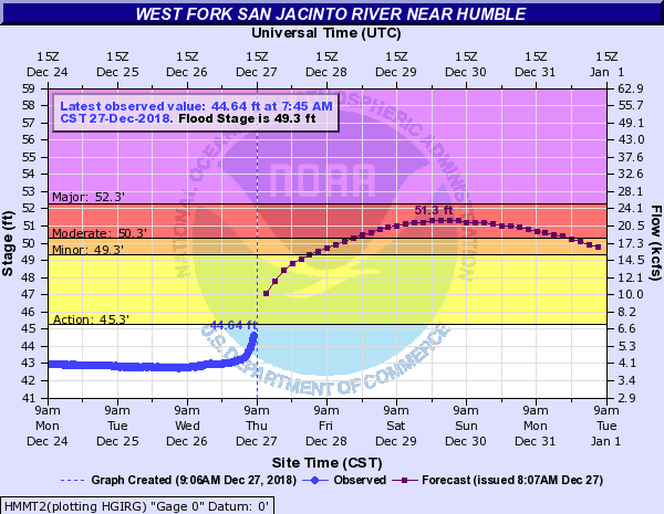
The River should rise above flood stage Friday morning and crest on Sunday. The flood will impact low lying roads near the river. The north side turnaround at US 59 and low points on Thelma Rd, Aqua Vista Dr, and Riverview Dr. will begin to flood. Water levels should approximate those reached in the December 7-8, 2018 event. Nearly all of the water heading into the West Fork is from significant run-off being generated on Cypress, Spring, and Lake Creeks.

The City did not lower Lake Houston in anticipation of this flood. However, the Coastal Water Authority is currently releasing 2500 cubic feet per second through the tainter gates on Lake Houston. It will be interesting to compare the ultimate water height to the Dec. 7-8 flood when the City did lower the Lake.

Here’s what the dock at River Grove looked like this morning. Photo courtesy of Bruce Casto.

Boat dock at River Grove around 9 a.m. on Thursday 12/27/18.

On December 8, River Grove looked like this.

River Grove Flood Level on December 8. Will this flood be higher?


East Fork Crest Delayed and Prolonged

East Fork residents can breath a little easier.

River is already rising at FM 1485 and nearing bankfull at FM 2090 (Plum Grove). Heavy rainfall over the headwaters of the river will move downstream from the Cleveland area and reach Plum Grove and FM 1485 this weekend. The river should rise to flood stage midday Friday and have an extended flat crest over the weekend near 60.5 ft. FM 1485 may be threatened at these levels along with low lying roads in subdivisions downstream of FM 1485. That’s Huffman and Kingwood!

Spring Creek

Significant run-off is in progress over the upper headwaters of Spring Creek and the creek is rising along the entire channel. Hegar Rd is at bankfull this morning and near bankfull conditions will be possible along the creek downstream to SH 249 and I-45. No structure flooding is expected, but some low lying roads near the creek or that cross the creek may be impacted…especially upstream of SH 249.

Cypress Creek

Significant run-off in the headwaters into Cypress Creek. Creek may reach near flood stage later today at Katy Hockley. Harris County Flood Control does not expect any significant downstream flooding east of Hwy 290 along Cypress Creek, although the creek will be very high as upstream water moves downstream.

Posted on 12/27/18 by Bob Rehak

485 Days since Hurricane Harvey

Where the Rain Fell

During last week’s major rain, the National Weather Service and others predicted that some of the heaviest rain would fall in the US59 corridor. In fact, it did…just not US59 North. A pocket of 6-8 inch rain hit Sugar Land, as you can see below.

Regional Rain Map From Last Storm

Regional rainfall map of last week’s big storm, supplied by National Weather Service

Two other pockets received 6-8 inches (red): The Woodlands and Huntsville. The vast majority of the area around Lake Houston received 4-5 inches (olive). Upstream from us, a small band through southern Montgomery County received 5-6 (orange). But upstream from Lake Conroe, the huge yellow area received only 3-4.

Diane Cooper, who sent this map to me, worked for the NWS for 20 years in various capacities including as a meteorologist, hydrologist and river forecaster. In predicting floods such as this, forecasters say, it’s important to look at rainfall upstream, not just your area.

How to Interpret

Reviewing such maps can help several ways. It can help predict peaks based on historical comparisons of rainfall. It can also help predict the timing of peaks, based on the distance high volumes have to travel. 

In this case, Lake Creek and the East Fork, because of heavy rainfall upstream, prolonged the high water in our area.


You can zoom from the entire United States to your own property, and even switch backgrounds, or highlight streams, by turning layers on and off.

By zooming out, you can see the storm as it approaches. And by varying the length of the period searched, you can get an idea of how much rain has fallen in the last 14, 30, 60, 90 and 120 days. You can even narrow the search to 1 hour to determine current intensity.

Where to Find

You can find all this regional information on the National Weather Service web site here.

If you forget the link, it’s always available on the Links page of this web site under the Weather/Flood Related subhead and a listing called NWS Regional Rainfall for the last 24 hours.

The site offers hundreds of different ways to search through information as varied as river stages “forecast” and “observed”; stream flow amounts; temperature; wind; visibility; ship observations and more. It’s one of the more powerful and useful online tools I have ever seen.

Play with it and learn how it works before the next storm. It can help reduce anxiety by showing you exactly what you’re up against. 

Precipitation for the last thirty days. Saturated ground makes for quick runoff.

You can even see where the storm went after it left here.  I’m just thankful I’m not one of those people buried under snow without power. Been there. Done that. Minnesota. January. It’s enough to make you a Texan. 

Posted by Bob Rehak on December 10, 2018

468 Days since Hurricane Harvey

FloodWarn Workshop Presentations Now Online

If you missed the FloodWarn Workshop at Kingwood College on 5/1/18, you missed a lot of helpful information. All four FloodWarn Workshop presentations are now posted in one PDF in the reports section of this web site or via this link.

National Weather Service

Distribution Map

Rainfall during Hurricane Harvey

Katie Landry-Guyton, Senior Service Hydrologist/Meteorologist from the National Weather Service-Houston/Galveston office, talked about various types of floods, then focused on river flooding. She discussed the various types of forecasts and warnings NWS has to help you understand levels of risk. She also discussed details of how NWS formulates forecasts. For weather wonks and flood victims, it’s a must-see.

Harris County Flood Control

Jeff Lindner, Meteorologist/Director, Hydrologic Operations Division of the Harris County Flood Control District then discussed the hydrology of Harris County. Within this context, he addressed four types of floodplains in the county, the District’s flood warning system (FWS), inundation mapping/ forecasting down to the street level, and expansion of the District’s gage network.

San Jacinto River Authority

Jace Houston, General Manager of the San Jacinto River Authority (SJRA), talked about the dam operations at Lake Conroe. Specifically, he explained how they made the decision to start releasing water during Harvey. Houston also introduced the SJRA’s new regional flood management initiative.

FEMA

Rounding out the evening, Diane Cooper of FEMA Floodplain Management and Insurance. Cooper, who has posted several times on this blog, is a Kingwood resident. She focused on flood risk, hazard mapping and flood insurance.

Among the surprising facts cited:

  • The National Flood Insurance Program processed 26,511 claims as a result of Harvey.
  • 55.2% of those claims came from OUTSIDE of the 100 year flood plain.
  • Only 17% of Houstonians had flood insurance (about 1 in 6)
  • 30,500 structures were in the 1% risk area (100 year flood plain)
  • 29,000 structure were in the 0.2% risk area (500 year flood plain)
  • City-wide, Harvey impacted approximately 150,000 structures
  • That means that more structures were impacted outside the 0.2% Risk Area than inside, approximately 90,000.

Cooper cited this last point as the reason why everyone should have flood insurance whether they are officially in the flood plain or not. This was a common theme all night among all four presenters.

They also pointed out that not all flooding comes from rivers. Much flooding comes from streets. Streets in Kingwood are designed as part of the flood retention system. They can deliver approximately two inches of rainfall per hour through the storm drains to the ditches. When the rainfall rate exceeds that, drains will back up into streets and release the water slowly so as not to overwhelm the ditches.

Moral of the story: even if you’re nowhere near the river or a drainage ditch, you can still flood from your street and, therefore, need flood flood insurance.

For more interesting tidbits, download and review all four FloodWarn Workshop Presentations.

Posted May 2, 2018

246 Days Since Hurricane Harvey

National Weather Service Hosting FloodWarn Workshop in Kingwood

On May 1st at 6:30-8:30 p.m., The National Weather Service (NWS), Harris County Flood Control, and FEMA, and the San Jacinto River Authority are hosting a FloodWarn Workshop. They will talk about the types of flooding we see in the Kingwood/Humble area, the watersheds, forecasts, warnings, flood risks, and flood insurance.

Organizers hope the event will help people in the Lake Houston Area better understand what goes into forecasts. They will also address their limitations, the risks associated with severe events, and actions to take in response to various types of warnings.

The NWS has posted the event on its Facebook page: The event is free and open to the public at Lone Star College – Kingwood at 20,000 Kingwood Dr., Kingwood, TX.

The National Weather Service provides forecasts and river flood warnings for the river gage at the San Jacinto River at Humble. Based on the readings there and elsewhere, the Weather Service forecasts “flood impacts.”

Flood impacts identify what structures, roads, bridges, etc. will flood when the river reaches a specific level. These impacts drive the establishment of the flood categories of Minor, Moderate and Major.

This FloodWarn workshop will be our opportunity to share our flooding concerns with the National Weather Service. If impacts need to be modified or updated, this is the community’s opportunity to provide that feedback.

So mark your calendar
Event: FloodWarn Workshop
Sponsors: National Weather Service, Harris County Flood Control, FEMA
For: Lake Houston Area Residents
When: 6:30-8:30 P.M., Tuesday, May 1, 2018
Where: Kingwood College, 20,000 Kingwood Drive, Kingwood, TX

Plan to attend. Make sure the NWS knows how important accurate and advanced warning forecasts are to you. With accurate forecasts we can be prepared for the next flood.

Posted April 22, 2018, 236 days since Hurricane Harvey