According to the rain gage in my back yard, more than half the rain this year has fallen this month. I recorded:
Year to date = 24.98 inches
Month to date = 12.72 inches
That’s 51%.
If that’s not impressive enough for you, consider this.
11.19 of the 12.72 inches in May fell this week.
Bob’s backyard rain gage
The week isn’t even over for another 15 hours, and it’s still raining.
Street flooding on West Lake Houston Parkway near Kingwood Drive on 5/17/21 after 5.5 inches of rain fell in about 2.5 hours.
This May Compared to 30-Year Average for May
Compare this to the 30-year running average at Bush Intercontinental Airport – 5.09 inches. We’ve already gotten more than twice the average for the month, this week.
May is usually the third wettest month of the year after June (5.93 inches) and October (5.70 inches).
The record for May is 14.39 inches in 1970. That means we’re 1.39 inches short of the record. The NWS predicts another inch may fall today in the Lake Houston Area. And we have another 8 days left in the month with a substantial chance of rain every day through next Wednesday. So this could easily become the new record…at least according to Bob’s backyard gage. (The official one is at the big airport, of course.)
Below are the official stats. They also include norms and extremes for temperature, wind, cloudiness and more.
Posted by Bob Rehak on 5/22/2021 based on information from the National Weather Service
1362 Days since Hurricane Harvey
https://i0.wp.com/reduceflooding.com/wp-content/uploads/2021/05/20210517-RJR_6619.jpg?fit=1200%2C800&ssl=18001200adminadmin2021-05-22 09:45:552021-05-24 14:43:14More Than Half the Rain This Year Has Fallen in May
According to the National Hurricane Center (NHC), recent satellite imagery suggests that a low-level circulation is forming associated with the disturbance over the Gulf of Mexico. The NHC has upgraded the chances of tropical formation from 20 percent to 40 percent overnight. However, shower and thunderstorm activity remains disorganized and the flood threat from the storm is minimal.
Overnight, NHC upgraded the chances for tropical development of the disturbance along the Texas Coast from 20% to 40%.
Conditions Marginally Conducive to Tropical Development
NHC says conditions are marginally conducive for development. A short-lived tropical depression or storm could form before the disturbance moves inland over the northwestern Gulf coast tonight.
NOAA predicts three day rainfall totals for the Houston area to range from 1-3 inches. Note the circular formation in the system.
Regardless of development, the system could produce heavy rainfall over portions of southeastern Texas and southwestern Louisiana during the next few days.
Jeff Lindner, Harris County’s meteorologist says, “There has been very little thunderstorm activity near the feature overnight with dry air wrapping in from the west.”
Lindner cites two forecast models that continue to attempt to close off the system nears the coast. “However, given the appearance this morning, this potential continues to be modest.”
Regardless of any development…impacts will be minimal, says Lindner. High rain chances in the forecast are a function of moisture levels over the central Gulf of Mexico which will be pushed westward over the next 24-36 hours and into southeast Texas.
Scattered showers and thunderstorms will develop with heating today and progress NW/WNW across the area.
Jeff Lindner, Harris County Meteorologist
Expect heavy rainfall under any areas of training cells. The National Weather Service has the eastern portions of the area under a slight risk for flash flooding today.
However, the scattered nature of the showers and thunderstorms should keep rainfall amounts manageable for most – generally in the 1-3 inch range today into Saturday.
If the system over the Gulf develops into a tropical storm or depression near the coast later today or tonight, expect an increase in the potential for thunderstorm training, especially in areas east of Houston.
River and Lake Report
The break most of us had from heavy rains yesterday let many rivers and streams recover. Lake Conroe remains a little more than a half foot above normal and continues releasing water at the rate of 2,665 cubic feet per second.
Lake Conroe level as of 7:30 am on Friday, May 21, 2021
And Lake Houston remains a little more than a foot above normal.
From Coastal Water Authority as of 5/21/2021 at 7:30 am.
Peach Creek at FM2090 is out of its banks but falling.
However, the East Fork at FM2090 and FM1485 is in danger of coming out of its banks.
Overall, the flood threat remains low for most of us with these few exceptions.
Posted by Bob Rehak on 5/21/2021, ten days from the official start of hurricane season, based on information from NHC, NWS, and HCFCD
1361 Days since Hurricane Harvey
https://i0.wp.com/reduceflooding.com/wp-content/uploads/2021/05/image003.gif?fit=800%2C561&ssl=1561800adminadmin2021-05-21 08:14:212021-05-21 08:14:25More Rain on Way, but Flood Threat Minimal for Most
After four days of heavy rains, today looked like a respite. This morning’s predictions mentioned another inch or two on Friday and Saturday. But then this the National Hurricane Center posted this within the last few minutes: a warning about what could turn into the season’s first tropical depression. And hurricane season doesn’t officially start for another ten days.
20% chance of formation for yellow area in next two to five days
20% Chance Before Official Start of Season
According to Jeff Lindner, Harris County Meteorologist, “The old complex of thunderstorms that moved off the Texas coast yesterday has festered over the west-central Gulf of Mexico today. While the satellite images look impressive, there appears to be no closed low pressure system at the surface and instead a surface trough extending across the region. Thunderstorms have been weakening this afternoon and there is no new development.”
Radar this morning showed storm festering in Gulf with a stationary trough drawing moisture up through Texas and Lousiana.
“So far this evening,” continued Lindner, “there is a large area of dry air to the west of the feature in the Gulf. The dry air will likely become entrained over time. However, some models show additional development for this feature as it moves generally toward the NW or NNW in the general direction of the Texas and Louisiana coastlines.”
NHC suggests the yellow feature has a 20% chance of developing into a tropical cyclone over the next 2 days.
This feature could help to enhance rainfall amounts over SE Texas this weekend, but any additional impacts beyond that at this time appear to be minimal, according to Lindner.
Take some time getting to know them know. During an actual storm, power outages and crowded bandwidth may make leisurely learning difficult.
Two other important sites for this area are the San Jacinto River Authority for Lake Conroe releases/levels and the Coastal Water Authority for Lake Houston levels. At this hour, the Lake Conroe is holding steady while releasing 2665 cubic feet per second. Lake Houston is still rising slightly with the flood gates wide open.
Lake Conroe Dashboard as of 7:30 PM on 5/20/21
Lake Houston as of 7:30PM , 5/20/21.
Posted By Bob Rehak on 5/20/21 Based on Information by NWS, NHC, HCFCD, SJRA, and Coast Water Authority
1360 Days since Hurricane Harvey
https://i0.wp.com/reduceflooding.com/wp-content/uploads/2021/05/two_atl_5d0-1.png?fit=900%2C665&ssl=1665900adminadmin2021-05-20 19:36:472021-05-20 19:49:12Could This Be the Start of Hurricane Season?
A serious flash flood threat remains in place over all of SE TX and much of eastern TX into Thursday.
According to Harris County Meteorologist Jeff Lindner, “After the storms from yesterday, deeper moisture has been pushed toward the coastline and offshore, but will rapidly return today.
A slow moving line of thunderstorms moved through the area on Monday producing generally 1 to 4 inches of rain across the area with localized areas of 6 to 8 inches in Liberty, eastern Montgomery, and northeastern Harris County.
The National Weather Service says that a lull in the precipitation occurred overnight, but the chance for heavy rainfall returns this morning as an upper level disturbance moves through the area. An additional 1 to 3 inches of rain with locally higher totals will be possible today. A stronger upper level disturbance will bring yet another round of heavy rain Wednesday into Thursday with additional rainfall totals of 2 to 4 inches of rain with again locally higher totals possible. Storm total rainfall by Thursday morning will average between 4 and 8 inches with isolated totals possibly exceeding 10 inches. The flood threat will be strongly dependent on where the rain falls and how quickly it falls.
Today-Tonight
Scattered showers and thunderstorms will develop with heating today. But it continues to be hard to pinpoint where storms may develop. By this afternoon, storms will likely begin to approach southeast Texas from the west and northwest. They may also possibly approach again from the northeast or north into the evening and overnight hours. See the satellite photo below.
Satellite image as of about 8 a.m. Houston time this morning.
Wednesday-Early Thursday
An upper level trough will transport extreme moisture into the region along with the jet stream. Models many possible scenarios from slow moving lines to quickly approaching complexes from the west. Regardless, the overall pattern favors heavy rainfall, flash flooding, and severe weather.
Rainfall Amounts
Lindner expects additional rainfall totals of 4-6 inches over the next 48 hours with isolated totals of 10-12 inches. Much of what falls is going to come in short intense bursts of rainfall, he says, and not spread out evenly over time.
The National Weather Service gives our eastern and northern counties a moderate risk of flash flooding today. The risk area should enlarge tomorrow across the entire region.
Excessive rainfall outlook for today
Excessive rainfall outlook for Wednesday and Thursday.
The orange areas indicate moderate risk. That means a 20-50% chance of excessive rainfall.
River, Stream Report
Run-off continues across the region this morning from the heavy rainfall yesterday. Cedar Bayou upstream of US 90 remains high, but has crested and is slowly falling. Spring Creek is rising as upstream run-off from northern Waller County moves into the mainstem of the creek. Not flooding is expected, but the creek will be elevated through the day. West Fork of the San Jacinto River is rising due to inflow from Spring and Cypress Creeks and will crest later this morning.
Both the SJRA and Coastal Water Authority are releasing water from Lake Conroe and Lake Houston preemptively. However, both lakes remain a few inches above their normal levels at the moment.
Additional rainfall over the next few days will quickly run-off resulting in new rises on area creeks, bayous, and rivers. Some flooding of creeks, bayous, and rivers will be possible.
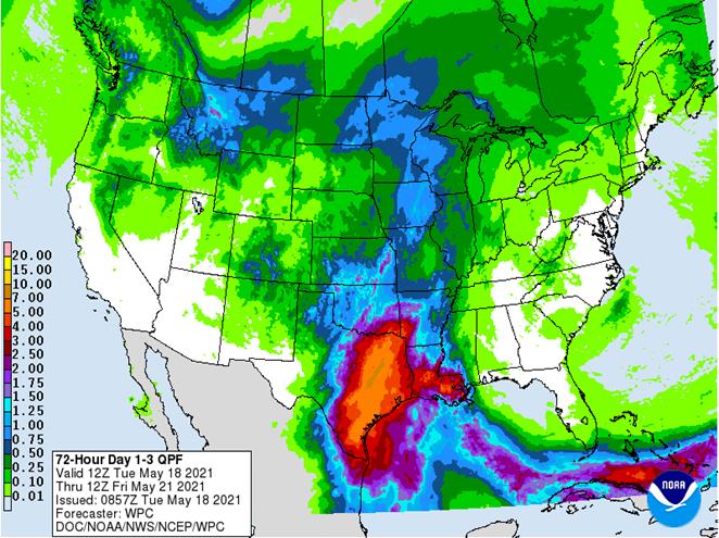
Forecasted Rainfall Next 72 Hours
Predicted accumulations through Friday. Source: National Weather Service
As I write this, the rain has started already this morning. Let’s hope the rain is spread out enough that the creeks can handle it. As predicted, so far it’s coming down in sporadic bursts mixed with light drizzle.
Posted by Bob Rehak on 5/18/2021 based on information provided by the NWS, HCFCD, and Donald Brown
1358 Days since Hurricane Harvey
https://i0.wp.com/reduceflooding.com/wp-content/uploads/2021/05/image009.jpg?fit=662%2C495&ssl=1495662adminadmin2021-05-18 08:56:082021-05-18 09:07:36Tuesday AM Rain Outlook: Heating Up, Flash Flood Watch Remains in Effect
The Texas Water Development Board (TWDB) and the federal Interagency Flood Risk Management (InFRM) team (composed of USGS, FEMA, the Army Corps, and National Weather Service) has enhanced their Flood Decision-Support Toolbox. The Toolbox is an interactive online application that provides maps and data that simulates the extent of flooding and shows historical flood extents. It can be used for analyzing potential scenarios, flood risk assessments, damage analysis, and more.
How It Works
Here’s how the Flood Decision-Support Toolbox works:
2. Observe current conditions OR select historical peak floods.
Historical peak floods at US59 and the West Fork. Note the increase in recent years, likely due to upstream development and/or climate.
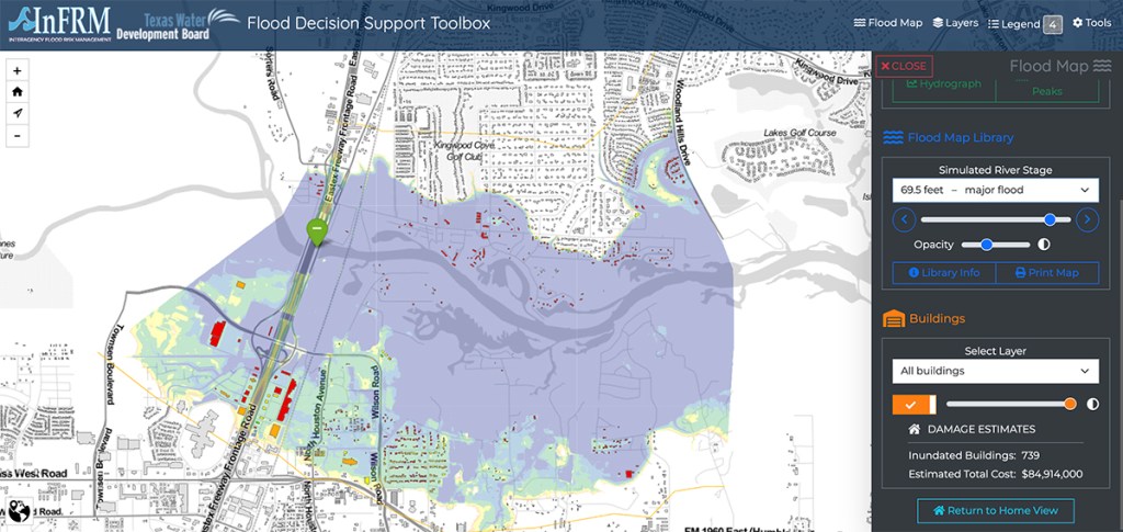
3. Explore the flood map library by selecting a flood level (river stage)
4. In the “Buildings” Layer, select ALL or INUNDATED BUILDINGS ONLY
5. Note the damage estimates in the bottom right hand corner of the screen.
In the case of a simulated Harvey flood, near the gage at US59, 739 buildings would be inundated at an estimated total cost of $84,914,000.
But at 52.5 feet (the beginning of the “major” flood stage), 83 buildings would flood. Estimated total damage: $1,494,000.
The magic of this toolbox is that you can see exactly which buildings will flood at any given level.
What is your appetite for risk?
Potential Uses
The Flood Decision Support Toolbox also provides real-time data from USGS streamgages connected with flood inundation models to interactively display a range of flood conditions at streamgage locations. The result is a dynamic tool for flood risk assessment that enables planners, emergency responders, and the public to visually understand a flood’s extent and depth over the land surface.
TWDB worked closely with USGS to incorporate building footprints on Texas maps. The Toolbox can now display potential damage to structures within the range of the USGS gages. This will give users the ability to estimate the economic impacts of different flood events on their communities and property. The TWDB has also provided building footprints outside of the current gage ranges in preparation for future mapping updates.
That can help guide:
Rescue efforts
Evacuations and evacuation routes
Mitigation decisions
Property purchases and investment decisions
Risk estimates
New construction and development
Permitting decisions
The site displays flood scenarios that range from minor to major flood events. New updates let users save and share inundation maps with different data layers through a unique URL.
Collaborative Effort
“This collaborative effort,” said Jeff Walker, Executive Administrator of the TWDB. “provides Texas-specific data that will help communities understand their local flood risks and make cost-effective mitigation decisions.”
The InFRM team was formed in 2014 and launched the Flood Decision Support Toolbox in 2019.
The TWDB is the state agency charged with collecting and disseminating water-related data, assisting with regional water and flood planning, and preparing the state water and flood plans.
Posted by Bob Rehak based on information provided by TWDB
1235 Days since Hurricane Harvey
https://i0.wp.com/reduceflooding.com/wp-content/uploads/2021/01/Simulated-Harvey.jpg?fit=1200%2C568&ssl=15681200adminadmin2021-01-15 06:33:322021-01-15 06:38:11Flood Decision-Support Toolbox Enhanced by State, Federal Team
At 4 AM Friday, Delta, as predicted, is headed for Louisiana. Houston will, however, feel some wind. The National Weather Service forecast for the Lake Houston Area today indicates showers likely, with thunderstorms also possible after 10am. Cloudy, with a steady temperature around 74. Breezy, with a northeast wind 10 to 20 mph, with gusts as high as 25 mph. I already have .2 inches of rain in my gage. New rainfall amounts between a quarter and half of an inch are possible today, says the NWS.
Friday night the chance of showers decreases to 40 percent, mainly before midnight. Mostly cloudy, with a low around 67. Breezy, with a northwest wind 10 to 20 mph, with gusts as high as 25 mph.
Outer bands of Hurricane Delta are already reaching the Houston Area.
Houston has a 30-40% chance of experiencing tropical-storm-force winds, i.e., greater than 39 mph.
If those winds arrive, expect them between late morning and early afternoon.
By tomorrow, Hurricane Delta should be a memory for us. Saturday will be sunny, with a high near 86. West wind 5 to 10 mph.
STORM SURGE WARNING IS IN EFFECT FOR…HIGH ISLAND TEXAS TO MOUTH OF THE PEARL RIVER LOUISIANA
HURRICANE WARNING IS IN EFFECT FOR…HIGH ISLAND TEXAS TO MORGAN CITY LOUISIANA
TROPICAL STORM WARNING IS IN EFFECT FOR…WEST OF HIGH ISLAND TO SARGENT TEXAS
Hurricane Delta Status
At 400 AM CDT, Delta is moving toward the north near 12 mph. National Hurricane Center (NHC) expects this motion to continue today followed by a north-northeastward motion by tonight. On the forecast track, the center of Delta will move inland within the hurricane warning area this evening. Maximum sustained winds approach 120 mph with higher gusts.
Note the wind extents.
Delta is a category 3 hurricane on the Saffir-Simpson Hurricane Wind Scale. Slow weakening is expected to begin as Delta approaches the northern Gulf coast later today, with rapid weakening expected after the center moves inland.
Hurricane-force winds extend outward up to 40 miles from the center. Tropical-storm-force winds extend outward up to 160 miles. The estimated minimum central pressure 953 mb (28.15 inches).
Not A Good Day to Travel East
The further east you go today toward Louisiana, the more danger. The core of the hurricane will strike the Louisiana coast this evening. Hazards include:
STORM SURGE:
A combination of dangerous storm surge and high tides will cause normally dry areas near the coast to be flooded by rising waters moving inland from the shoreline. The water could reach the following heights above ground.
Port O’Connor, TX to High Island, TX including Galveston Bay…1-3 ft
High Island, TX to Sabine Pass…2-4 ft
Sabine Pass to Holly Beach, LA…4-7 ft
Rockefeller Wildlife Refuge, LA to Morgan City, LA including Vermilion Bay…7-11 ft
Small changes in Delta could have large impacts on where the highest storm surge occurs. The deepest water will occur along the coast near and to the east of the landfall location. Large and dangerous waves will accompany surge. Stay tuned for possible changes and updates.
Surge-related flooding depends on the relative timing of the surge and the tidal cycle, and can vary greatly over short distances.
WIND:
Hurricane conditions are expected within the hurricane warning area by this afternoon, with tropical storm conditions expected within this area later this morning. Tropical storm conditions are expected within the tropical storm warning areas later today.
RAINFALL:
Today through Saturday, Delta is expected to produce 5 to 10 inches of rain, with isolated maximum totals of 15 inches, from southwest into central Louisiana. These rainfall amounts will lead to significant flash, urban, small stream flooding, along with minor to major river flooding.
For extreme east Texas into northern Louisiana, southern Arkansas, and western Mississippi, Delta is expected to produce 3 to 6 inches of rain, with isolated maximum totals of 10 inches.
SURF:
Swells from Delta will likely cause life-threatening surf and rip current conditions.
Posted by Bob Rehak on 10/9/2020 based on data from NWS and NHC
1137 Days after Hurricane Harvey and 386 after Imelda
https://i0.wp.com/reduceflooding.com/wp-content/uploads/2020/10/HGX_loop.gif?fit=600%2C550&ssl=1550600adminadmin2020-10-09 06:26:072020-10-09 07:49:56Worst of Delta Will Miss Lake Houston Area to East
1 P.M. Wednesday, October 7, 2020 – As of 1 P.M. Wednesday, the National Hurricane Center issued three watches affecting the Houston region in conjunction with Hurricane Delta:
Hurricane watch from High Island TX to Grand Isle, LA
Tropical Storm watch from San Luis Pass to High Island including all of Galveston Bay
Storm surge watch from High Island, TX to the Alabama/Florida Border
Watches mean conditions could develop in the area, most often within the next 48 hours.
Swells will build into the 15-20ft range offshore on Thursday into Friday and 7-12 feet near the coast. This will result in wave run-up on the Gulf facing beaches and likely some degree of coastal flooding at the typical vulnerable locations.
Cone Still Includes Parts of East Texas
The National Hurricane Center indicates Hurricane Delta has now passed over the Yucatan. It weakened over land, but should strengthen again into a major Hurricane over warm waters in the southern Gulf of Mexico. Delta will move northwest today and then shift north on Thursday, according to NHC. By Friday morning, most of the central Gulf Coast will feel Delta in the form of higher winds, tides and storm surge.
While the cone of uncertainty associated with Hurricane Delta has consistently focused east of the Houston Area, it’s important to understand that ANYWHERE in the cone has an equal chance of being directly hit. And Houston is still near the western side of the cone.
Houston Most Likely Will Be on Dry Side
Luckily, Houston should be on the dry side of this storm. So we will likely not receive flooding rains, as least as far inland as the Lake Houston Area. The graphic below from the National Weather Service shows most of the predicted rainfall will happen east of us.
Jeff Lindner, Harris County Meteorology, says, “Rainfall will generally average less than 2 inches east of I-45 in some outer squalls on the west side of Delta.”
Wind is Primary Threat in Lake Houston Area
The NHC has adjusted its intensity forecast downward for Delta. However, it should still regain major hurricane status. The wind field will likely grow in size as the storm approaches the northern Gulf coast. That will increase the storm surge and wind threats. At this time, the NHC forecasts that the Lake Houston Area has a 40-50% chance of experiencing tropical-storm-force winds.
The most likely arrival time of those winds is Friday morning.
Don’t plan a picnic under the old oak tree for Friday.
Jeff Lindner, Harris County Meteorologist says, “Squalls on the western side of the circulation of Delta will begin to move onshore and into the area on Thursday afternoon and continue into Friday along with gusty winds. Tropical storm force winds may be possible over the SE and E parts of the area, especially Chambers, Galveston, Liberty, and southeast Harris Counties. But this will depend on the overall expansion of the wind field of Delta on Thursday and Friday.”
Posted by Bob Rehak at 2 PM on Wednesday 10/7/2020based on information from HCFCD, NWS and NHC
1135 Days since Hurricane Harvey and 384 since Imelda
https://i0.wp.com/reduceflooding.com/wp-content/uploads/2020/10/Potential-Storm-Surge-for-Delta.jpg?fit=1200%2C1175&ssl=111751200adminadmin2020-10-07 14:17:152020-10-07 16:59:51Hurricane Delta Watch from High Island to Grand Isle; Tropical Storm Watch for Galveston Bay
As of 11 a.m. Friday morning, we have Tropical Depression 14 and Tropical Storm Laura poised to enter the Gulf of Mexico. Forecasters predict both could intensify into Category 1 hurricanes. Not many living people can remember the last time we had two hurricanes in the Gulf at the same time. Jeff Lindner, Harris County’s meteorologist found only one other instance. That was in 1933 when two tropical systems made landfall near the Florida panhandle and near Brownsville, Tx.
That said, the National Hurricane Center updated forecasts for TD14 and Laura at 11 a.m. Here are the current positions of the storms.
TD 14 is the most imminent threat. It is currently in the Bay of Honduras battering the Bay Islands.
TD 13 intensified into a tropical storm overnight and was given the name Laura. It is near the windward islands, heading NW toward Cuba and Florida. The big question: Will land interaction weaken the storm? At this hour, some models show it dissipating. Others show it intensifying into a hurricane.
Current Forecast for TD 14
The Lake Houston Area could start feeling tropical storm force winds (greater than 39mph) by next Monday night.The current most likely timing for the arrival of TS (40mph) winds would be around 11:00 p.m. Monday to 2:00 a.m. Tuesday.Current forecasts show the storm briefly intensifying into a hurricane and then diminishing to a tropical storm as it approaches the upper Texas Coast between Tuesday and Wednesday mornings. NHC says it’s too early to determine exact impacts to the upper Texas coast. Too much uncertainty remains.
Rainfall Potential
Last night, Channel 2 KPRC news predicted the possibility of 12 – 18 inches of rain out of this storm. That may be high.
At this time, Jeff Lindner, Harris County Meteorologist, predicts the storm will drop 3 – 5 inches of rain, mainly to the east of I-45, with some higher amounts possible.
“Grounds are very dry over the region, so the area soils will be able to handle some rainfall…at least a few inches…before significant run-off begins,” says Lindner. “Confidence is not high on the track and that will in the end determine where the maximum rain falls…with most of the heavy rain falling along and east of the track of the center.”
Meanwhile, the National Weather Service is only predicting a 50-60% chance of rain for next Tuesday.
The lower estimates may give hope to the people in Elm Grove who flooded last year. The detention ponds now in place on Woodridge Village were designed to handle that much rain. But if we got 18″…
At this time, the SJRA is not releasing any water. Lake Conroe is at 199.84 feet. Lake Houston is down about three-quarters of a foot from its normal level.
Tropical Storm Laura
Tropical Storm Laura is currently racing west at 21 mph.The outer tropical storm force winds could arrive in Louisiana by Tuesday morning next week. That’s about 12 hours after TD-14 arrives on the Texas coast.Laura will likely intensify into a hurricane by the come it strikes the eastern Gulf coast.
Some Interaction Between Two Storms is Possible
Some models indicate interaction between TD 14 and Laura. That could slow TD 14’s forward motion over the Gulf. However, at this time, it is unclear whether Laura will have any influence on TD 14.
Preparation
Remember: Chance favors the prepared. Make sure you have fresh batteries. Stock your supplies. Fill your gas tank. Refill your prescriptions.
Check weather forecasts at least two or three times a day.
https://i0.wp.com/reduceflooding.com/wp-content/uploads/2020/08/145757-1.png?fit=897%2C738&ssl=1738897adminadmin2020-08-21 12:11:372020-08-21 12:11:50Not Since 1933 Have Two Hurricanes Hit the Gulf Simultaneously
The official rain gage at West Lake Houston Parkway and the West Fork San Jacinto recorded 2.32 inches of rain between 7 and 9 a.m. this morning. That was officially a 1-year rain. (See Atlas-14 chart below.) As rains go, it was not a severe test; it was more like a pop quiz.
After the rain subsided, Taylor Gully in Elm Grove was less than half full.
The good news: Taylor Gully was well within its banks and no one in Elm Grove or North Kingwood Forest flooded. The bad news: Perry’s detention ponds experienced severe erosion, enough to warrant repairs and perhaps delay the schedule.
The even worse news: Harris County’s meteorologist, Jeff Lindner predicts another one to two inches of rain tonight with isolated totals of three to four.
West Lake Houston Pkwy. Gage Showed 2.32 Inches In 2 Hours
24 hour rain totals for WLHP gage showed bulk fell in 2 hours.
2.32 inches in two hours qualifies as a one-year rain according to the new Atlas-14 rainfall precipitation frequency estimates. Even if you considered the entire 3.12 inches in 24 hours, it would still only be a one year rain.
Atlas 14 Precipitation Frequency Table for the Kingwood Area.
Aerial Images Show How Perry Detention Ponds Performed
These aerial images taken shortly after noon today when the rain stopped show that:
The detention ponds are starting to do their work and hold back water.
That kept the level in Taylor Gully manageable
The overflow spillway between S2 and the concrete-lined channel was apparently not needed.
However, the images also show that:
Portions of the detention pond walls severely eroded and appear to have collapsed in places.
The water in the N1 pond overcame temporary dirt barricades sending water and silt down to N2.
The newly excavated N2 was entirely covered with water for the first time. It also received a significant amount of erosion.
N3 merges with Taylor Gully to form one large detention pond that holds water all the way from the northern end of the pond to the county line.
Rain has halted construction for the last two days and could delay it into next week.
Expanded, giant N2 detention pond was covered entirely with water for first time.Looking West toward western border of Woodridge Village.However, erosion re-deposited large amounts of soil within the pond. Looking North along Western Border of Woodridge Village.Rainwater entering the site from Joseph street in Porter (center left) shows by comparison how much silt the Perry water held. Looking north along western border of Woodridge Village.Still looking north, but farther up western border, you can see silt slumping into ditch.Looking SE toward Elm Grove and North Kingwood Forest from the NW corner of site. Water coming in N1 pond from left exited right, down the western border. Water washed out a temporary dirt barrier that appeared designed to hold water in the pond.Looking east. Note erosion from former utility corridor on left that has turned into a new drainage ditch along northern edge of property. Looking at western wall of N3 which runs along eastern border of Woodridge Village.Another portion of the western wall of N3 shows severe erosion.Standing water from rest of property is slowly making its way into detention ponds.Looking South along eastern border toward Taylor Gully. At present, N3 (bottom left) simply merges with the concrete channel by S2 (top right). It appears to have nothing to control the outflow.Looking north along eastern border. Silt fences prove inadequate at stopping erosion. In fact, most of site has no silt fences.
More Rain Likely Tonight
Jeff Lindner, Harris County meteorologist, says that today’s wet pattern should remain in place through the weekend, contrary to earlier predictions that saw rain chances ending by Friday.
Storms currently in the Gulf near Corpus Christi are tracking toward Houston late tonight and Friday morning. They will probably not be as severe as this morning’s storms. With that said…the air mass remains tropical over the region and excessive rainfall rates of 2-3 inches per hour will be possible, warns Lindner.
As of 6 p.m. Thursday, the National Weather Service decided NOT to issue another flash flood watch for tonight, but stay alert to see if a more significant threat may develop.
Expect rainfall amounts of generally 1-2 inches tonight with isolated totals of 3-4 inches.
To Get Up-to-the-Minute Forecasts and Stream Alerts
1031 Days since Hurricane Harvey and 280 since Imelda
The thoughts expressed in this post represent opinions on matters of public concern and safety. They are protected by the First Amendment of the US Constitution and the Anti-SLAPP Statute of the Great State of Texas.
https://i0.wp.com/reduceflooding.com/wp-content/uploads/2020/06/20200625-DJI_0004.jpg?fit=1200%2C900&ssl=19001200adminadmin2020-06-25 18:39:552020-06-25 18:44:17Perry Detention Ponds Pass First Modest Test, But Eroded Badly
On February 20, NOAA announced computing upgrades that will enable new and improved weather and climate forecasting. Significant upgrades to supercomputing capacity, storage space, and interconnect speed of its Weather and Climate Operational Supercomputing System will keep the agency’s supercomputing capacity on par with other leading weather forecast centers around the world.
Why We Need More Supercomputing Capacity
As good as weather forecasting has become, it can still go much further. That’s why this item caught my eye.
Triple Capacity, Double Storage and Interconnect Speeds
This increase in high-performance computing will triple the capacity and double NOAA’s storage and interconnect speed. It will help NOAA create better forecast model guidance. The keys: higher-resolution and more comprehensive Earth-system models that use larger ensembles, advanced physics, and improved data assimilation.
“We will restore America’s international leadership with the best weather forecasts, powered by the fastest supercomputers and world-class weather models,” said Neil Jacobs, Ph.D., acting NOAA administrator.
Two new Cray computers, an operational primary and backup, will be located in Manassas, Virginia, and Phoenix. The computers each have 12 petaflop capacity. They will become operational by early 2022 after code migration and testing.
New Total of 40 Petaflops
Coupled with NOAA’s other research and development supercomputers, which have a combined capacity of 16 petaflops, NOAA’s new prediction and research computing capabilties will reach 40 petaflops.
A petaflop is a unit of computing speed equal to one thousand million million (1015) floating-point operations per second.
Earth Prediction Innovation Center
The new computers will help advance research and development under NOAA’s emerging Earth Prediction Innovation Center (EPIC). They should make the U.S. Global Forecast System the best model in the world.
“Through EPIC, we have an opportunity to regain our footing as a world leader in global weather prediction. The system will foster partnerships with university and industry scientists and engineers to advance U.S. numerical weather prediction,” added Jacobs.
EPIC will make it easier for developers across all sectors to collaborate on improving the nation’s weather and climate models. It leverages combined skills and resources and lowers barriers for interaction. It does that through the use of cloud computing and a community modeling approach called the Unified Forecast Systemoffsite link.
Current Acquisition Will Lay Ground for Future Advances
“The National Weather Service ran a competitive acquisition to ensure we have the supercomputing power needed to implement all the great modeling advancements we anticipate over the next several years,” said Louis W. Uccellini, Ph.D., director of the National Weather Service. “This is an exciting time for all of us in the weather research and operations community, with bold changes on the horizon. We are making sure NOAA is ready.”
Posted by Bob Rehak on 2/27/2020 based on information provided by NOAA
912 Days since Hurricane Harvey
https://i0.wp.com/reduceflooding.com/wp-content/uploads/2020/02/Digital-Globe.jpg?fit=1200%2C744&ssl=17441200adminadmin2020-02-27 18:27:082020-02-27 18:32:29NOAA to Triple Supercomputing Capacity for Weather, Climate Forecasting