Tag Archive for: Liberty County

Conflict-of-Interest Ridden Colony Ridge Caught Operating without Permit, Polluting

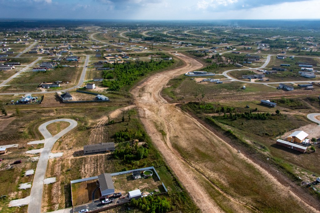
11/20/25 – Maria Acevedo, a construction expert and environmental activist, observed a Colony Ridge cement contractor, Liberty Paving, operating without a permit. She also documented sediment runoff from the site that violated Texas Commission on Environmental Quality Best Management Practices (BMPs).

The lack of BMPs was polluting the surrounding area, which drains into the San Jacinto East Fork and has required tens of millions of dollars in dredging since the development of Colony Ridge began.

Acevedo reported the alleged violations to the TCEQ, which conducted its own investigation and issued a Notice of Enforcement.

Liberty Paving LLC, the contractor, has done more than $13 million worth of business for Liberty County Municipal Management District #1. Amazingly, the President of MMD #1 owns the paving contractor.

This letter from Attorney General Ken Paxton to members of Congress details a litany of other abuses and ethically ambiguous practices at Colony Ridge in Liberty County. Loopholes in Texas law big enough to drive cement trucks through enable them.

TCEQ Finds No Site Signage or Stormwater Pollution Prevention Plan

When TCEQ investigated Acevedo’s complaint, it was not raining, so investigators could not confirm the allegations of runoff that Acevedo’s photos showed. However, TCEQ discovered that Liberty Paving was operating without coverage under the Construction General Permit, required site signage, and a mandatory Stormwater Pollution Prevention Plan (SWPPP). Neither was the company employing best management practices.

As a result, TCEQ issued a Notice of Enforcement Letter. TCEQ’s report says that Liberty Paving knew of its responsibilities because of permits issued at other sites outside Colony Ridge, but failed to comply inside Colony Ridge.

What exactly does TCEQ mean when it issues a notice of enforcement for “failure to obtain coverage under the Construction General Permit”? According to ChatGPT, the permit regulates:

  • Stormwater runoff from construction activities
  • Erosion controls
  • Sediment controls
  • Pollution prevention practices

Because the site began construction without filing the required notice of intent:

  • Any stormwater discharges were unauthorized
  • Discharged pollutants, such as sediment, were illegal.
  • The operator is out of compliance with the Clean Water Act and Texas Pollution Discharge Elimination System rules
  • Even if erosion controls were physically present, failure to obtain the permit still constitutes a violation.
Sediment escaping through improperly installed silt fence. Photo by Maria Acevedo.

Conflict of Interest?

John Harris, the Colony Ridge developer, lists himself as the president of T-Rex Management, Inc., the general partner of Liberty Paving, LLC. But Harris is also the current president of Liberty County MMD #1.

Minutes of MMD #1 show that in 2023, Harris’ brother was president of the MMD when it approved $13 million in payments to Liberty Paving.

In most states this would be a clear conflict of interest. But Texas allows it if the parties recuse themselves from voting on the contract/payment and disclose their conflicts of interest.

Mr. Harris was evidently present for one vote on paving payments, but absent for another. The minutes do not reflect whether he disclosed the conflict of interest.

That’s pretty academic, however, when four MMD board members have ties to the developer or Harris’ family.

One former state legislator who is an expert on MMDs told me that even if a board member recuses himself, other members of the board know how to vote through winks and nods, i.e., things that don’t get recorded in minutes. He raised some interesting questions. Are bids sealed? Are bids opened in public with all bidders present? And should the vote to accept a bid count if the board member who refrains from voting is necessary to make a quorum?

According to ChatGPT, Texas stands out nationally due to MMDs being allowed to:

  • Reimburse developers via taxpayer-backed bonds
  • Have developer-controlled boards
  • Contract with developer-owned companies
  • Reimburse developers for on-site infrastructure, including:
    • Roads
    • Water/sewer
    • Drainage
    • Detention ponds
    • Grading & clearing
    • Engineering costs

Most states allow reimbursement only for:

  • True regional infrastructure, or
  • Public facilities beyond subdivision boundaries.

Nor do other states allow developers to:

  • Form districts they control
  • Levy taxes on future residents
  • Reimburse themselves for subdivision improvements.

However, it’s standard practice in Texas for:

  • A developer to form a MMD or Municipal Utility District
  • The developer (or allied consultants) to serve on the board
  • The board to hire the developer’s own companies for construction, engineering, landscaping, or management
  • Taxpayers or landowners to repay the MMD or MUD through bonds or assessments.

Such practices are widely criticized as ethical conflicts of interest, even if they are not legal conflicts. They enable self-dealing and private gain from public-like financing powers. Yet it’s all technically legal if conflicts are disclosed and abstentions handled properly.

However, the Liberty County Attorney, Matthew Poston told Houston Landing

“The scandal isn’t what is illegal. The scandal is what is legal.”

Matthew Poston, Liberty County Attorney
Colony Ridge
Colony Ridge Expansion in 2022.

Paxton Writes Scathing Colony Ridge Letter to Legislators

In Texas, the Attorney General does not normally police MMD self-dealing. However, two years ago, when illegal immigrant and consumer fraud scandals rocked Colony Ridge creating national headlines, Attorney General Ken Paxton wrote a scathing letter to members of Congress about his offices’ findings.

Among other things, Paxton’s four-page letter details how:

  • Colony Ridge practices seem to contradict the intent of Texas lawmakers when they established MMDs
  • Minimal down-payment, high-interest loans with little identity verification lure non-citizens across the border
  • Fast growth and high crime create burdens on law enforcement, school districts, and neighboring areas
  • MMD #1 violates the intent of lawmakers
  • How MMD #1 bypasses bank scrutiny of its high risk activities contrary to the public interest
  • Unelected, unaccountable leaders are creating unsustainable growth of a “city” by catering to illegal aliens
  • How Colony Ridge is swamping taxpayers in the Cleveland ISD which caused it to more than triple in size
  • The people of Texas “never assented to the creation of a sprawling unincorporated, ungoverned zone.”

And Paxton didn’t even address Colony Ridge flooding!

Colony Ridge Drainage
For everyone who wants to own an Island Home. New Year’s Day of 2021.

For More On Colony Ridge

Consult this post – History of Heartbreak: A Colony Ridge Chronicle. It contains links to more than 75 previous posts with hundreds of photos taken on the ground and in the air. Scanning through them will make you wonder whether Paxton was too kind!

A development that didn’t exist 15 years ago is now 50% bigger than Manhattan … with hardly any flood control, fire hydrants, or police presence.

Posted by Bob Rehak on 11/20/25

3005 Days since Hurricane Harvey

Karma Strikes Again: Colony Ridge Drainage Systems Severely Eroding

October 8, 2023 – Karma is fast catching up with the corner-cutting Colony Ridge developer in Liberty County. Drainage infrastructure that doesn’t meet Liberty County regulations is fast eroding.

And tomorrow, a special session of the Texas legislature will start investigating the embattled development. The special session will focus on crime, infrastructure, illegal immigration, and more.

To offset negative publicity, the developer invited legislators to meet at his development last week and tour it.

But just before the meeting, Liberty County deputies, a narcotics unit, and SWAT team responded to an abduction at gunpoint. They also launched a manhunt for two escaped suspects in the sprawling development, which is now 50% larger than Manhattan.

On the day of the developer’s meeting, the main entrance to the development flooded. Badly. Ditches designed to keep roads clear in a 5-year storm overflowed during a 1-year rain.

The next day when the storm clouds cleared, an aerial survey showed that Colony Ridge drainage channels and stormwater detention basins were badly damaged.

Had the developer simply followed Liberty County regulations, he could have reduced or avoided the costly damage.

Missing Erosion Controls

Section 50 of Liberty County’s Subdivision and Development regulations specifies requirements for construction of drainage ditches and stormwater detention basins.

The County emphasizes the need to control erosion and sedimentation. It warns these twin threats can have very serious effects on stormwater ditches and basins. Specifically, they can:

  • Cause slope failures
  • Reduce the efficiency of drainage channels
  • Clog drainage culverts
  • Reduce channel capacity
  • Reduce maintainability of drainage facilities
  • Increase maintenance costs
  • Require more frequent repairs
  • Increase turbidity
  • Impair water quality.

To counter these problems, the regulations say…

“Interceptor structures and backslope swale systems are required to prevent sheet flows from eroding the side slopes of open channels and detention facilities.”

Liberty County Subdivision and Development Regulations, Page 100

The diagram below explains how they work.

backslope interceptor design

The regulations also specify design requirements for these structures and other erosion control measures. Altogether, Colony Ridge apparently violated requirements for:

  • Backslope interceptor and swale systems
  • Bermuda grass on side slopes of channels and ditches
  • Erosion controls around outfall pipes
  • Geo-textile bedding under rip rap
  • Pilot channels at the bottom of detention basins
  • Maintenance strips
  • Storage of excavated dirt
  • Side-slope angles

Not all locations in Colony Ridge exhibit all problems. Regardless, karma was swift. Thursday’s 1-year rain severely eroded the side slopes of channels and basins. Eroded sediment also started filling in new ditches and basins.

Repairs and compliance – if attempted – will be costly and time consuming.

Karma Hurts Residents Upstream and Down

While critics might rejoice at the karma, others will pay the price. The developer’s practices increase flood risk for people in Colony Ridge as well as those downstream.

  • In the development, erosion threatens property.
  • Downstream, sediment reduces the conveyance of streams, increasing flood risk.

TCEQ has warned the developer about his construction practices before. But many dubious practices continue. See photos below.

The first two are NASA satellite images from Google Earth. I shot the rest on 10/6/23 with one exception.

Threat to Colony Ridge Residents

When a three-mile ditch down the center of Colony Ridge was completed, it was about 120 feet wide at the yellow line.

August 2017

Today, it’s 76 feet wider.

Residents on EACH side lost 38 feet of their back yards.

This ditch has steadily widened since its construction. Without backslope interceptor swales or grass to reduce erosion, millions of cubic feet of dirt swept downstream from this single ditch.

Then, when the water slowed at the headwaters of Lake Houston, the sediment dropped out of suspension, reducing the conveyance of the East Fork San Jacinto.

Here are several shots showing what that erosion damage looks like up close from a helicopter.

The ravine forms more ravines.
No room for a maintenance road here.
Or here.

Virtually every ditch in Colony Ridge has erosion and compliance problems. Here’s another one.

No maintenance road. No backslope interceptor swales. No grass on sides of ditch. Note: home on right has no back fence. What happened to it?
Note piles of dirt stored where they can erode back down into ditches.

Even detention basins in the newer sections of Colony Ridge have erosion problems. Again, most don’t have grass on the side slopes. Nor do they have backslope interceptor swales. Many, like the one below, don’t have room for maintenance roads.

Note the erosion threat already to these recently placed mobile homes in a newer section of Colony Ridge.
Erosion will soon threaten one of the new roads in Colony Ridge. Regs specify that rip rap like you see here should have had a geo-textile lining under it to reduce erosion.
Erosion washed sediment into new basin. Also note how erosion is starting to block the outfall at the lower right.
No backslope swales here. Not much Bermuda grass either. Regs say “side slopes shall be no steeper than 3 horizontal to 1 vertical (3:1).”
No grass or backslope interceptor system here. No pilot channels either.
Note piles of excavated dirt stacked on both sides of road, eroding back into ditches.

As all those ditches and basins gradually fill in, they will add to future flood risk.

But repairing such issues will be a big, costly challenge – one that the developer has ignored for years.

Threat to Downstream Residents

All this erosion also contributes to downstream flooding and likely violates Section 11.086 of the Texas water code. It states that “No person may divert … the natural flow of surface waters in this state … in a manner that damages the property of another…”

Where does all that eroded sediment eventually go? To Lake Houston, of course.

East Fork San Jacinto downstream from Colony Ridge on Thursday 10/5/23 – same day as shots above.

The river slows down where it meets the headwaters of Lake Houston. That causes sediment to drop out of suspension.

Harris County, City of Houston and the State just finished a major dredging effort on the East Fork that cost the public tens of millions of dollars.

Before dredging, it looked like this.

East Fork Mouth Bar after Imelda and before dredging. This bar grew 4,000 feet between Harvey and Imelda.

But the cost is only part of the issue. Reduction in the river’s conveyance contributed to the flooding of thousands of nearby homes during Harvey and Imelda.

Harris County Commissioners Court May Address Issues on Tuesday

Drainage is a public-safety issue. And it’s not the only one caused by the developer’s disregard for regulations.

  • Colony Ridge has filled in wetlands.
  • TCEQ has also documented problems with the Colony Ridge sewage system that led to a 48,000 gallons of fecal matter escaping into Lake Houston, the source of drinking water for 2 million people.
  • Colony Ridge does not have enough fire hydrants or water pressure to comply with the Liberty County fire code.

Harris County Commissioners Court may discuss these problems on Tuesday at the request of Precinct 3 Commissioner Tom Ramsey, PE. See Item 406 on the Agenda.

The developer alleges that racism motivates criticism of his Hispanic development. But racism does not explain flooding, feces and fire.

The failure of a developer to follow regulations shouldn’t pit Liberty County against Harris County, rich against poor, or Democrats against Republicans.

We all suffer equally. We all face increased risk. And Colony Ridge is one issue where we should all find common cause.

I hope that Commissioners Courts in both counties support the legislature’s investigation into Colony Ridge. I also pray that both Counties can work together to protect all residents.

Posted by Bob Rehak on 10/8/23

2231 Days since Hurricane Harvey

The thoughts expressed in this post represent opinions on matters of public concern and safety. They are protected by the First Amendment of the US Constitution and the Anti-SLAPP Statute of the Great State of Texas.

Damn the Downstream Consequences, Colony Ridge Expansion Continues Relentlessly

Damn the downstream consequences, including sediment pollution, increased flood risk and monstrous dredging costs. Colony Ridge, the controversial 30+ square-mile, Liberty County development that markets to Hispanics – while flaunting drainage, environmental and fire regulations – is clearing and paving thousands of additional acres.

Not even Google Earth can keep up with the developer’s relentless expansion. On 8/12/23, I flew over Colony Ridge in a helicopter and found huge areas where 3-week-old satellite imagery was already hopelessly out of date.

Google Earth image from 7/18/23. Red/yellow highlighted areas changed radically within three weeks.


With the exception of areas protected by the Houston-Conroe and Tarkington Bayou Mitigation Banks, the highlighted areas above have largely been cleared and/or paved.

The RED area now has paving not visible in the satellite image. The YELLOW area was being cleared and paving was just starting even though the image shows none of that. So what do these areas look like from a few hundred feet?

Pictures Taken 8/12/23 over Red Area

I shot the four pictures below on 8/12/23. They represent dozens of others. The red area already has most streets, but no fire hydrants.

Pictures Taken over Yellow Area

The two pictures below show some of the development activity taking pace in the yellow area.

Looking west across newly cleared area.
Looking N at part of Colony Ridge expansion.

What kind of homes will go here? To predict the future, look to the past.

Homes on Parade

Colony Ridge is the world’s largest trailer park. One Plum Grove resident who lives near a northern entrance to Colony Ridge says she routinely sees up to seven mobile homes per day going into the development – seven days per week.

It’s hard to know exactly how many new homes arrive each day, because there are other entrances. But if you assume the max for this one entrance, 50 homes a week times 52 weeks makes up to 2600 homes per year.

Colony Ridge Expansion
Manufactured home making its way through the main commercial area of Colony Ridge.
Room with a viewof severe erosion.

Note the erosion in photos above and below. It will make its way downstream into the East Fork San Jacinto. These ditches are typical of Colony Ridge. The eroded sediment will reduce conveyance of the river and contribute to flooding.

Poverty: The Mother of Pollution

Ghandi once said, “Poverty is the mother of pollution.” That’s certainly the case here. But I would modify the saying. While poverty may be the mother of pollution; greed is the father.

The poverty of the residents doesn’t cause sediment pollution. But a business plan built on high-interest-rate, owner financing that targets impoverished people with few options does.

The developer seems to have found a target market that is less concerned with their environment than survival.

It’s a market ripe for exploitation where corners can be cut. Residents have few options and can’t complain.

And the developer shows little interest in changing a business model that fuels relentless expansion and growth. Damn the downstream consequences.

In virtually every area I have photographed, he has not planted vegetation on the banks of the channels. Nor has he used silt fences or installed backslope interceptor swales to reduce erosion as Liberty County regulations require.

Instead of the developer bearing those costs, downstream residents in the Lake Houston Area do. Since Harvey, the Army Corps, Harris County and City of Houston have spent more than $220 million of your tax dollars to dredge excess sediment shed from rivers of mud like this.

Colony Ridge drainage ditch.
Working drainage is a luxury.

The poverty in Colony Ridge is crushing. I’ve seen people sleeping in tents trying to save enough money to buy a camper to live in.

No bathroom in sight. Do Liberty County health codes really allow this?
Christmas dinner. Enlargement of this photo from Christmas 2020 shows food on the table in the foreground.
One small part of Colony Ridge. The market for a piece of the American dream stretches endlessly in Liberty County.

The estimated population of Colony Ridge is now greater than the three largest cities in Liberty County (Cleveland, Dayton, and Liberty) put together. No one knows what the population is with certainty because of the large number of undocumented aliens who did not participate in the last census.

And the Colony Ridge developer is expanding into Harris and Montgomery Counties. ReduceFlooding will monitor progress of those areas to see if they, too, contribute to sediment accumulation, dredging costs, and flooding.

Posted by Bob Rehak on 9/9/23

Posted by Bob Rehak 2202 Days since Hurricane Harvey

The thoughts expressed in this post represent opinions on matters of public concern and safety. They are protected by the First Amendment of the US Constitution and the Anti-SLAPP Statute of the Great State of Texas.

Colony Ridge Stormwater Detention Basins, Ditches Fail to Meet Liberty County Standards

Colony Ridge, the world’s largest trailer park, fails to meet Liberty County regulations for the construction of stormwater detention basins and ditches. The development’s basins and ditches routinely lack erosion controls such as grass and backslope interceptor swales. The resulting erosion can reduce the conveyance of streams, increase flood risk and threaten property both inside the development and downstream. The failure to follow those regulations imposes a hidden tax on residents of Liberty and surrounding counties.

No Bare, Earthen Slopes Allowed

Page 100 of the Liberty County Subdivision and Development Regulations updated in 2019 states that, “All drainage facilities must be designed and maintained in a manner which minimizes the potential for damage due to erosion. No bare earthen slopes will be allowed.

Backslope Drain Systems Required

Pages 152 and 153 of the regulations also require backslope drain systems to “intercept sheet flow which otherwise would flow over the banks of drainage channels leading to erosion of the side slopes.” Swales behind the edges of basins and channels trap stormwater. Pipes then carry it to the bottom of the ditch or basin so that it won’t erode side slopes.

What Ditches/Detention Basins Should Look Like

The photo below shows a Harris County ditch with grass on the side slopes and pipes that lead from backslope swales to the bottom of the channel. Note how they reduce erosion and sedimentation.

Harris County ditch which follows regulations similar to Liberty County’s. Compare the Colony Ridge ditches below.

Compare Requirements to Photos

I took the pictures below on 8/12/23 from a helicopter while flying over Colony Ridge in Liberty County. Note the lack of grass and interceptor inlets/outlets. Also note the severe erosion that results.

Note severe erosion on banks of pond. Also note lack of backslope swales, inlets, and outlets in base of pond.
No backslope interceptor system. No grass.
No backslope interceptor system. No grass on sides of ditch.
Ditto.
Ditto

In some cases, the ditches and detention basins don’t even have perimeter maintenance roads and the erosion is cutting into people’s back yards.

Colony Ridge Household slipping into drainage ditch

Colony Ridge resident losing back of property due to ditch erosion.

The Largest Development Few Know About

Colony Ridge is large and growing rapidly. The satellite image below shows how it has virtually doubled in size within the last two years as it has grown from left to right and bottom to top. The large area in the lower left began developing around 2011. Those lines that look like hashmarks are thousands of mobile homes.

Colony Ridge Expansion
This satellite image taken in July 2023 does not even show the development’s current extent. Much of the area in the upper right below the clouds was cleared since then. See below.
Portion of Colony Ridge in upper right of satellite photo has now been cleared.

Colony Ridge already comprises more than 30 square miles. That makes it approximately one third the size of the area inside Houston’s 610 loop.

Mostly mobile homes and rivers of mud as far as the eye can see.

Erosion a Major Issue

Colony Ridge drains into three watersheds: the East Fork San Jacinto, Luce Bayou and Tarkington Bayou. And all of them drain into Lake Houston. That will make erosion from Colony Ridge Harris and Liberty County’s problem forever.

During floods, erosion will reduce the conveyance of downstream channels and rivers. Page 148 of the Liberty County Subdivision and Development Regulations has this to say about the effects of erosion and sedimentation.

  • “Erosion and sedimentation can have very serious effects on storm water drainage.”
  • “Erosion can cause slope failures, increase roughness coefficients, and generally reduce the efficiency of drainage channels. However, sediment deposition can clog drainage culverts and reduce the available conveyance in open channels.”
  • “Erosion can significantly reduce the maintainability of drainage facilities and increase the cost of maintenance by increasing the frequency with which repairs are required.”

LJA engineering wrote a letter to the Liberty County Engineer that underscores the need to plan ahead as the county transitions from rural to urban. “While limited regulation of development in a rural area may not significantly impact drainage issues, Liberty County is now challenged with explosive population growth and a particularly high percentage of socially vulnerable residents…” said the letter.

Hidden Cost to Downstream Residents

Most people in Harris County don’t even know that Colony Ridge exists. Yet the drainage practices there affect dredging costs downstream. The City of Houston, Harris County and Army Corps spent almost a quarter billion dollars dredging the headwaters of Lake Houston between Harvey and mid-2021.

Clearly, not all of that sediment came from Colony Ridge. However, the development practices in Colony Ridge and other developments like it will set the pattern for the future.

Developments are virtually impossible to change after people start building next to undersized basins and ditches that erode more with every substantial rain.

What You See Makes You Question What You Don’t See

Substandard construction practices make you wonder about engineering practices. Did Colony Ridge engineers produce reliable, accurate estimates of drainage needs? Are those ditches and detention basins sized properly? Will they hold enough runoff to protect residents?

Probably not. Even assuming engineers and contractors did their jobs properly (a big assumption), Liberty County still defines a 100 year/24 hour rainfall as 13.5 inches (see page 108), a rate associated with pre-Atlas 14 days.

Atlas 14 catalogs the current national precipitation frequency standards for every community in the U.S.

However, the phrase “Atlas 14” appears nowhere in the 2019 Liberty County Subdivision and Development Regulations.

But NOAA now defines a 100 year/24 hour rainfall for nearby Cleveland, TX, as 17.1 inches – a 27% increase above the current Liberty County standard. So in a hundred-year rainfall, everything you see in Colony Ridge will be 27% short of capacity. Few people likely understand this.

Consider also that NOAA is already working on replacing Atlas 14 with Atlas 15!

Posted by Bob Rehak on 8/16/23

2178 Days since Hurricane Harvey

The thoughts expressed in this post represent opinions on matters of public concern and safety. They are protected by the First Amendment of the US Constitution and the Anti-SLAPP Statute of the Great State of Texas.

GLO Announces Regional Mitigation-Project Approvals Totaling $128 Million

Two pieces of good news came out of the Texas General Land Office (GLO) in two days! Yesterday, the GLO announced that both Houston and Harris County met their respective expenditure goals for Harvey disaster-relief funds. Today, Commissioner Dawn Buckingham M.D. announced the approval of more than another $128 million worth of flood-mitigation projects in the region.

This batch of funds includes several major projects in the north Houston region:

  • City of Dayton received $1.45 million for sewer rehabilitation.
  • Liberty County received $21.27 million to develop a master-drainage plan and make drainage improvements.
  • Waller County received $6.7 million for drainage improvements and another $2 million for Prairie View Water Improvements and a Planning study.

Of these, the Liberty County batch stands out for its sheer size. And Liberty County will need it. That’s because of the recently completed Grand Parkway. It cuts a wide arc through the county’s farms and fields. Thousands of acres are currently under development thanks to improved transportation. And they will stress local watersheds, such as the San Jacinto East Fork and Luce Bayou.

Intersection of State Highway 99 (Grand Parkway) and FM1960 shortly before grand opening last year.
Just north of the Grand Parkway, Colony Ridge is doubling in size.

Another Liberty County example.

FM2090 at East Fork of the San Jacinto in Liberty County on May 3, 2021. New development has flooded Plum Grove and areas farther south along the East Fork.

And another.

FM 1010
Also in Plum Grove, FM1010 washed out at Rocky Branch during Harvey and has yet to be repaired.

Scope of HUD/GLO Awards

The GLO awarded the U.S. Department of Housing and Urban Development funds to improve street, water and drainage facilities in Brazoria, Fort Bend, Galveston, Jefferson, Liberty, Matagorda, Nueces, Polk, San Jacinto, and Waller Counties.

This is a separate tranche of money from the Houston and Harris County disaster-relief funds discussed in yesterday’s post.

$128,208,664 will benefit 19 federally eligible infrastructure projects to improve streets as well as water and drainage facilities. The cities of Aransas Pass, Coldspring, Corrigan, Dayton, Freeport, Hitchcock, Iowa Colony, Katy, La Marque, Palacios, Pearland, Richwood, Rosenberg, Shepherd, Texas City, and the counties of Jefferson, Liberty, and Waller will all receive the mitigation dollars.

Difference Between Disaster Relief and Flood Mitigation

Disaster relief dollars help individuals recover from past floods. Mitigation dollars, on the other hand, help strengthen infrastructure against future floods.

According to the GLO, HUD defines mitigation as “Activities that increase resilience to disasters and reduce or eliminate the long-term risk of loss of life, injury, damage to and loss of property, and suffering and hardship, by lessening the impact of future disasters.”

Locally-Led Methods of Distribution

The approvals announced today will filter down to cities and counties through regional councils of governments (COGs), such as the Houston-Galveston Area Council (HGAC).

Through its Regional Mitigation Program, the GLO enabled local prioritization. This local prioritization will have a tremendous impact across multiple regions, according to Commissioner Buckingham.

“Locally-led prioritization of mitigation projects is important because it strengthens critical infrastructure and protects communities against the impacts of natural disasters,” said Buckingham. “At the Texas General Land Office, we are not only helping those in need, but also supporting our communities as they grow.”

Who Will Get What

The table below shows a high-level description and the award amount for each of the 19 projects. For detailed descriptions of each project, click the caption below the table.

For project descriptions, click here.

How the Money Got from D.C. to Texas Projects on the Ground

The Texas General Land Office (GLO) allocated $1,166,997,000 in Community Development Block Grant Mitigation (CDBG-MIT) funds from the U.S. Department of Housing and Urban Development (HUD) for the Regional Mitigation Program. The program aims to reduce the risks and impacts of future natural disasters.

Each Council of Government (COG) with HUD-designated eligible counties developed a method of distribution (MOD) for allocation of funds to units of local governments. Each COG developed its MOD through extensive public participation.

HUD requires that at least 50% of total funds must be used for activities benefiting low- to moderate-income (LMI) persons.

For more information, please visit recovery.texas.gov/mitigation.

Posted by Bob Rehak on 6/20/23

2121 Days since Hurricane Harvey

Montgomery, Liberty Counties Still Have Not Adopted Minimum Drainage Recommendations

After Hurricane Harvey, Harris County Engineering examined regulations throughout the region and recommended minimum drainage standards to reduce future flooding in the region’s cities and counties. Harris County even offered to pay the cost of inventorying existing standards and having an engineering firm draft recommended revisions. But almost 2000 days after Harvey, only half of the area’s cities and counties have taken action. Among those not acting: Montgomery and Liberty Counties. Here’s a breakdown of who has done what as of January 18, 2023, according to Harris County.

Already Upgraded

Twenty took Harris County up on its offer. They have already successfully updated their drainage regulations. They include:

  • Cities of
    • Baytown
    • Bellaire
    • Bunker Hill Village
    • Deer Park
    • El Lago
    • Friendswood
    • Galena Park
    • Hilshire Village
    • Houston
    • Humble
    • Jersey Village
    • Katy
    • La Porte
    • Pasadena
    • Piney Point Village
    • Seabrook
    • Southside Place
    • Taylor Lake Village
    • Tomball
  • Waller County

Considered Updates But Haven’t Acted

Twelve had requested and received an analysis, but had not yet implemented recommendations. They include:

  • Cities of:
    • Hedwig Village
    • Jacinto City
    • League City
    • Missouri City
    • Nassau Bay
    • Pearland
    • Shoreacres
    • South Houston
    • Spring Valley
    • Webster
    • West University
  • Fort Bend County

Not Acting

Eight have not updated ordinances and regulations. These include communities that did not respond to and those that refused Harris County’s offer. They include:

  • Cities:
    • Hunter’s Creek Village
    • Morgan’s Point
    • Stafford
    • Waller
  • Counties:
    • Brazoria
    • Galveston
    • Liberty
    • Montgomery

In fairness, Montgomery County did hire a firm in August 2022 to update/revise its drainage criteria manual and subdivision rules. The scope of work included examining some of the recommendations below made by Harris County. But work was expected to take at least a year.

Recommendations for Minimum Drainage Standards

The minimum drainage standards recommended by Harris County included:

  • Use Atlas 14 rainfall rates for sizing storm water conveyance and detention systems.
  • Require a minimum detention rate of 0.55 acre feet per acre for any new development on tracts one acre or larger. However, single-family residential structures and accessory buildings on existing lots would be exempt.
  • Prohibit the use of hydrographic timing as a substitute for detention on any project, unless it directly outfalls into Galveston Bay.
  • Require “no net fill” in the current mapped 500-year flood plain, except in areas identified as coastal zones only.
  • Require minimum Finished Floor Elevation (FFE) of new habitable structures be established at or waterproofed to the 500-year flood elevation as shown on the effective Flood Insurance Study.

I would add one more to the list:

  • No clearing or grading before environmental and drainage studies are completed, and during grading, measures are taken to protect neighbors from runoff.

This seems to be particularly troublesome issue for those surrounding new developments.

Self Interest

Harris County Engineering originally positioned adoption of the minimum drainage standards as a condition for receiving partnership money from the 2018 flood bond.

Clearly, not everyone sees that has a powerful incentive. Those outside Harris County likely see little benefit, especially since the Equity Prioritization Framework has delayed funding in those areas.

Perhaps Harris County should have emphasized how adoption of the minimum standards could help reduce flooding for ALL people in the region – including those within Montgomery and Liberty Counties.

During heavy rains in late January, I received dozens of reports of flooding in Montgomery and Liberty Counties. As growth in surrounding areas explodes, lax regulations are starting to inflict suffering on those area’s own citizens.

They should adopt higher standards for their own benefit, not just Harris County’s.

Photo taken January 30, 2023 along Harris/MoCo border near San Jacinto West Fork after 1.32 inches of rain.

Posted by Bob Rehak on 2/5/23

1986 Days since Hurricane Harvey

The thoughts expressed in this post represent opinions on matters of public concern and safety. They are protected by the First Amendment of the US Constitution and the Anti-SLAPP Statute of the Great State of Texas.

Harris County Commissioners Reaffirm Need for Minimum Drainage Standards in Region

On Tuesday, April 5, 2022, Harris County Commissioners Court reaffirmed the need for minimum drainage standards in the region. The program called “Fix Flooding First,” was started in 2020 by the Harris County Engineering Department. It is designed to help prevent flooding, not just fix it. The idea: to bring all municipalities and other counties that drain into Harris County to adopt minimum drainage standards.

Big Box Stores in Humble opposite Deerbrook Mall along US59 during Harvey. 130,000 cubic feet per second came downstream from Montgomery County which has declined to work with Harris County in adopting minimum flood regulations.

Altogether, the West Fork and East Forks of the San Jacinto with Peach and Caney Creeks, all of which drain through rapidly developing Montgomery County sent 300,000 cubic feet per second into the Lake Houston Area during Harvey.

To see how many square miles are being drained upstream from you, consult this map. Almost half of the watersheds in Harris County originate outside the county.

watersheds in Harris and surrounding counties
Watersheds in Harris and surrounding counties.

Seeking Agreement on Five Measures

Five minimum measures, recommended by the Office of the County Engineer and Harris County Flood Control District, include:

1. Use Atlas 14 rainfall rates for sizing storm water conveyance and detention systems.
2. Require a minimum detention rate of 0.65 acre-feet per acre of detention for any new development on tracts one acre or larger. A single-family residential structure and accessory building proposed on an existing lot is exempt from providing detention.
3. Prohibit the use of hydrograph timing as a substitute for detention on any project, unless it directly outfalls into Galveston Bay.
4. Require “no net fill” in the current mapped 500-year floodplain, except in areas identified as coastal zones only.
5. Require the minimum Finished Flood Elevation of new habitable structures be established at or waterproofed to the 500-year flood elevation as shown on the effective Flood Insurance Study.

Harris County Has Little Leverage

Harris County doesn’t have much leverage in this request. It can’t force neighbors to do anything. Compliance more or less depends on good will and a recognition that flooding in Houston and Harris County can affect the whole region negatively. Working together ultimately benefits everyone.

However, Harris County does have two small carrots. The County hired a consultant to review existing flood regulations in neighboring jurisdictions and make recommendations to bring them up to minimum standards. The county also can approve (or reject) partnership projects with those neighbors.

Mixed Results; No Change Since January

As of the start of this year, the program had met with mixed success.

  • 16 municipalities (including Houston, Humble) and Waller County had successfully upgraded their regulations.
  • 14 municipalities and Fort Bend County had completed the analysis of the regulations but not fully upgraded them yet.
  • 8 (four municipalities and four counties) did not respond to the offer of the analysis, refused it, or refused to participate.

As of last Tuesday, those results had not changed since January when I last reported on this program. The same municipalities and counties were in each category. Liberty and Montgomery Counties both fall into the last category (did not respond or refused).

Compliance list from January has not changed as of April 5, 2022.

Establish Precedent for Regional Cooperation Now

Harris County can spend billions on flood mitigation, but if upstream communities keep sending more water downstream, we may never see improvement. 

Ironically, all the upstream communities will be downstream from other developing communities in the future and may be in the same position that Harris is in today. It would be good to establish precedent for regional cooperation now that they could use themselves in the future.

Studies show that for every dollar spent on flood prevention, they can save five dollars on flood mitigation. That’s money that could go into improving the quality of services and infrastructure in communities….without forcing people through the trauma of flooding!

Posted by Bob Rehak on 4/7/22

1682 Days since Hurricane Harvey

What Does “No Adverse Impact” Really Mean in Drainage Studies?

New developments in many jurisdictions must demonstrate “No Adverse Impact” (NAI) in drainage studies before they can get construction permits. City and county engineers want to know the development won’t harm others before they approve plans. But what does “No Adverse Impact” really mean? It depends on the jurisdiction.

Meaning Varies

Most jurisdictions require that new developments won’t add to flooding. In Montgomery County, for instance, developers do this by comparing runoff pre- and post-development. If engineers can show that post-development runoff does not exceed pre-development runoff, then they get their permit.

Such studies focus primarily on water surface elevations. But the Association of State Floodplain Managers (ASFPM) has a much broader definition.

In their book, No Adverse Impact means that actions of any community or property owner, public or private, “should not adversely impact the property and rights of others.” 

An adverse impact can be measured by an increase in flood stages, flood velocity, flows, the potential for erosion and sedimentation, degradation of water quality, or increased cost of public services. 

ASFPM

Definition Should Apply Beyond Floodplain

According to ASFPM, “No Adverse Impact” floodplain management extends beyond the floodplain to include managing development in the watersheds where floodwaters originate. NAI does not mean no development. It means that any adverse impact caused by a project must be mitigated, preferably as provided for in the community or watershed-based plan.

Here’s a presentation that covers NAI at a high level. Some key points include:

  • Flood losses are increasing by $6 billion annually. That’s because current policies promote intensification in high risk areas. They ignore changing conditions, undervalue natural floodplain functions, and often ignore adverse impacts.
  • Even if we perfectly implemented current standards, damage will increase.
  • Floodplains change due to filling.
  • Current regulations deal primarily with how to build in a floodplain vs. how to minimize future damages.
  • NAI actually broadens property rights by protecting those adversely impacted by others.
  • Trends in case law show that Act of God defenses have been greatly reduced due to ability to predict hazards events.
  • Hydraulic models facilitate proof of causation.
  • Use of sovereign immunity has been greatly reduced in lawsuits.
  • Communities are most likely to be held liable not when they deny a permit, but when they permit a development that causes damage to others.

Where to Find More Information About NAI

ASFPM has extensive information on the guidelines for “no adverse impact.”  They include NAI How-to Guides For…

This 108-page PDF from ASFPM sums it all up in one easy-to-download file.

Recent Case Study of Adverse Impact

Earlier this week, I toured Plum Grove to survey flood damage from the January 8/9 rains.

Between Saturday afternoon on 1/8 and Sunday morning on 1/9, Plum Grove received about 6.9 inches of rain.

NOAA’s Atlas-14 rainfall probabilities for this area show that’s about a 5-year rain.

atlas 14 rainfall probabilities
NOAA’s Atlas-14 Rainfall Probability standards for the Lake Houston Area.

But rising floodwaters cut off large parts of Plum Grove – including escape routes. The new elevated City Hall nearly flooded again even though it’s far above the 100-year floodplain.

Local residents and city officials attribute their flooding woes to largely unmitigated development in nearby Colony Ridge. The City is currently suing the developer.

Flooding two weeks ago was so bad that the Plum Grove Volunteer Fire Department sealed off roads and warned people to stay out. Currents were reportedly moving fast enough to sweep cars off roads.

Photo from evening of 1/8/2022 courtesy of Plum Grove VFD after about six inches of rain.

As far as I can tell, 2004 Liberty County Subdivision Rules do not require “no adverse impact” for new developments. However, they do stipulate that “All roads and streets shall be designed to convey a 10-year storm event and not more than 6″ of water over the road in a 100-year storm event.”

Looks like the engineers missed all of those targets! This is a good example of why all jurisdictions should specify No Adverse Impact in their drainage regulations.

Posted by Bob Rehak on 1/20/22

1605 Days since Hurricane Harvey

The thoughts expressed in this post represent opinions on matters of public concern and safety. They are protected by the First Amendment of the US Constitution and the Anti-SLAPP Statute of the Great State of Texas.

Silence: Liberty County, Colony Ridge, Landplan Engineering Remain Mute on Missing Documents

Wayne Dolcefino titles his latest video “The Sounds of Silence.” It’s about the Colony Ridge problems in Liberty County and the response of officials.

On December 26, 2020, I reported about missing drainage reports for the Colony Ridge development in Liberty County. The post also discussed the mischaracterization of soil types in the reports that did exist. The mischaracterization let the developer overestimate the infiltration of rain and thus underestimate runoff. That meant he needed fewer detention ponds and smaller ditches. And that, in turn, meant the developer could sell more lots. But then the flooding started. Coincidental?

Sounds of Silence

On January 4, 2021, Liberty County Attorney Matthew Poston launched an investigation.

But four months later, the documents are still missing. Without explanation.

Either they got lost or were never developed in the first place. And no one will defend or explain the soil sampling in the documents that were produced.

Neither will anyone talk about how large parts of Colony Ridge got approved by the County without the required engineering documents certifying “no negative effect” on drainage upstream or downstream from the development (see page 5). Note: Plum Grove Road has been washed out since Harvey and keeps getting worse. Neither will they talk about whether conditions at Colony Ridge comply with Liberty County regulations.

  • Jay Knight, the Liberty County Judge, won’t talk.
  • Greg Arthur, Liberty County Precinct 2 Commissioner, won’t talk.
  • David Douglass, the Liberty County Engineer, won’t talk.
  • Louis Bergman, the former Liberty County Engineer, won’t talk.
  • Trey Harris, the developer of Colony Ridge, won’t talk.
  • Earnest Bailes, Liberty County’s state rep won’t talk.
  • Phil Struble, CEO of Landplan Engineering, won’t talk.

Enter Wayne Dolcefino, Investigator Extraordinaire

Wayne Dolcefino, formerly one of the country’s foremost investigative journalists and now a private investigator for the Plum Grove City Council, picked up the scent of a coverup. And he’s running it to ground…all the way to the Liberty County Courthouse and the headquarters of Landplan Engineering in Kansas. Landplan served as the engineering company for the Colony Ridge developer.

Merry Christmas from Colony Ridge. Photographed December 7, 2020. On August 11, 2015, Trey Harris, Colony Ridge Developer, told Liberty County Commissioners he “would work with the County to assure his subdivisions were ones Liberty County could be proud of.” (See top Page 5).

Simon and Garfunkle’s 1965 hit The Sounds of Silence became the theme song for Dolcefino’s latest exposé. In the 13-minute video, Dolcefino asks officials difficult questions about persistent problems that have driven off half of tiny Plum Grove’s population in the last few years.

I never get tired of watching Dolcefino wave his microphone in front of people who walk away to avoid answering questions.

From Dolcefino’s latest video on Colony Ridge. Trey Harris turns his back to Dolcefino and walks away rather than answering questions.

For those who enjoy hard-hitting investigative journalism that speaks truth to power, this is a must-view video.

When it’s all over, you’ll ask yourself the biggest question of all: “Are these officials protecting the people who elected them or each other?”

We may soon find out. I interviewed Dolcefino this afternoon. He told me that his company, Dolcefino Consulting, is filing criminal complaints against State Representative Earnest Bailes and Commissioner Greg Arthur for failure to produce records requested under the Texas Public Information Act.

Keep your eye on this one. It has the potential to affect cozy relationships between developers and officials throughout the state.

Posted by Bob Rehak on 4/23/2021 based on a video by Wayne Dolcefino

1333 Days after Hurricane Harvey

The thoughts expressed in this post represent opinions on matters of public concern and safety. They are protected by the First Amendment of the US Constitution and the Anti-SLAPP Statute of the Great State of Texas.

Photo Essay: How “Backslope Interceptors” Reduce Erosion, Ditch Maintenance, Flood Risk

“Backslope interceptors” help prevent erosion that can clog drainage ditches and contribute to flooding. Most people have probably seen them, but never paid much attention to them. Nor do they understand can reduce ditch maintenance costs by lengthening maintenance intervals. This photo essay shows what a difference they can make. All three counties in the Lake Houston Area require them, but Liberty County doesn’t enforce its own regulations. So the visual differences are dramatic.

What Are They? How Do They Work?

We’ve all observed water flowing through drainage ditches. But how does it get into the ditch? Broadly speaking, it can get into the ditch by a) flowing down the banks or b) through pipes. Option A increases erosion. Option B decreases it. B also reduces flood risk and the long-term cost of ditch maintenance.

What is a backslope interceptor? Imagine a small ditch (or swale) parallel to but offset from the main ditch. The swale captures runoff and overland sheet flow before it gets to the main ditch. The swale then funnels the flow into pipes that run under the banks of the main ditch. Keeping large volumes of water off those banks reduces erosion which could otherwise quickly fill the ditch with dirt and reduce its carrying capacity. If erosion reduces carrying capacity enough, water can flood nearby homes and businesses. The illustration below shows how backslope interceptors work.

Real-Life Examples

On 3/3/2021, I flew over three counties: Harris, Montgomery and Liberty. The “with/without” photos below illustrate the difference that properly constructed backslope interceptors can make. I shot the first one over the new Artavia development in southern Montgomery County. Note how the backslope interceptors let the developer establish grass on the banks of the ditch despite construction still in progress.

Ditches WITH Backslope Interceptors
Artavia ditch in Montgomery County. Note series of backslope interceptors behind the maintenance roads that flank the ditch.
Drainage ditch in Atascocita in Harris County. Again, backslope interceptors let grass establish on the sides of ditches, reducing erosion.
Wider shot along same ditch.
Ditches WITHOUT Backslope Interceptors

The rest of these examples came from Colony Ridge in Liberty County.

Lack of backslope interceptors has led to severe erosion. Runoff goes straight down the banks of ditch and into the East Fork San Jacinto.
Close up of same Colony Ridge ditch.

Role in Establishing Grass

The next two photos show the role of backslope interceptors in establishing grass. By preventing bank erosion from sheet flow, the interceptors give grass time to establish and grow, reducing erosion even more.

Ditch in Artavia, a still-developing area in Montgomery County, where developer has recently hydromulched to establish grass.
Liberty County ditch in newly developing part of Colony Ridge, also recently hydromulched. Without backslope interceptors, hydromulch has washed into bottom of ditch and will eventually wash away, leading to more severe erosion.

How Enforcing Regulations Can Reduce Costs, Flooding

Ironically, Liberty County drainage regulations updated in 2019 require developers to install backslope interceptors and plant grass on the banks of drainage ditches.

Page 100 states: “Erosion Control: All drainage facilities must be designed and maintained in a manner which minimizes the potential for damage due to erosion. No bare earthen slopes will be allowed. [Emphasis added] Various slope treatments, including turf establishment, concrete slope paving, and rip- rap, are accepted. Flow velocities should be kept below permissible values for each type of slope treatment. Interceptor structures and backslope swale systems are required [Emphasis added] to prevent sheet flows from eroding the side slopes of open channels and detention facilities.”

Unfortunately, Liberty County does not enforce its own regulations.

When the developer eventually tries to turn Colony Ridge over to Liberty County, the county will inherit as massive maintenance burden because of non-compliance with these regulations. But even before then, the developer is creating rivers of mud that reduce the conveyance of ditches, and thus contribute to flooding nearby residents in Plum Grove.

This Colony Ridge drainage ditch in Liberty County is rapidly filling in. Residents use it for joy-riding in their ATVs, which further contributes to erosion.

The sediment also contributes to dredging and water purification costs for people downstream in Harris County.

Posted by Bob Rehak on 3/6/2021

1285 Days since Hurricane Harvey and 534 since Imelda

The thoughts expressed in this post represent opinions on matters of public concern and safety. They are protected by the First Amendment of the US Constitution and the Anti-SLAPP Statute of the Great State of Texas.