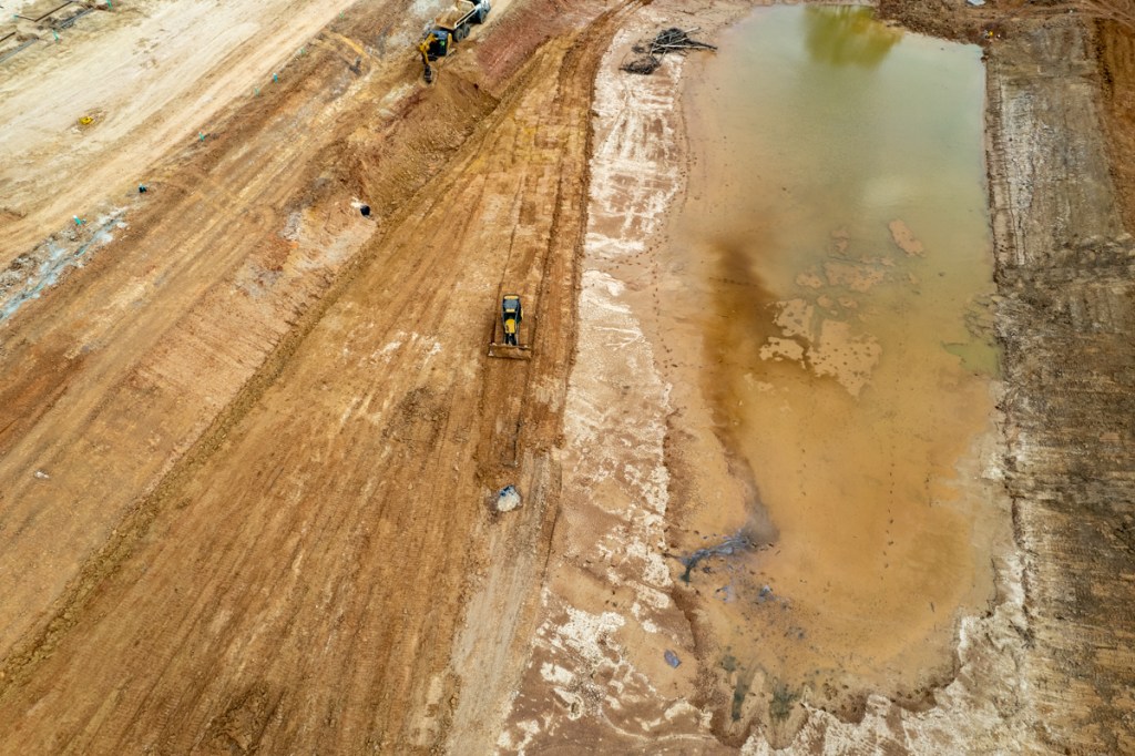
Only 31 of the 226 parking spots at the new Laurel Springs RV Resort appeared occupied today – despite deep grand-opening discounts, a record cold winter up North, and a few saplings planted on the 20+ acres of concrete.
Triangular dog park features one complimentary sapling for male dogs.Railroad tracks in trees in right. Looking NNW across RV Resort from over Laurel Springs Lane.
Nephew Izzy to the Rescue
Not even Nephew Izzy could understand it. “Uncle Bob, they don’t even have oil spots on the pavement yet! And look at all the privacy you could have.”
Izzy is a connoisseur of trailer and RV parks. He and his new girlfriend, Wanda June, a dancer down at the Crystal Pistol, grew up in them.
I asked, “Ya think it might have anything to do with trains running up and down those tracks all day and all night long, Izzy?”
“I could have that place filled up by next weekend, Uncle Bob.”
“How’s that?”
“I’d make Wanda June the check-in clerk. She packs them in down at the Crystal Pistol.”
“She does have a way with people. But desk clerks don’t get too many tips, Izzy.”
“I see your point, Uncle Bob. Could cut down on our income.”
Romance of the Railroad and Wide Open Spaces?
“Hey, how about if we give out free Johnny Cash tapes at check in? Capitalize on the romance of the railroad.”
“You mean like Folsom Prison Blues?”
“Yeah, that’s the ticket. Johnny Cash is awesome.”
“Hmmm. Maybe not the perfect choice,” said Izzy. Then brightening, “I know! I’d sell ‘Wide Open Spaces!'”
“Well, they certainly have lots of those.” A big pause.
“What’s wrong, Uncle Bob?”
“Do you think that will cause people to ask why no one’s there?”
“Maybe free hearing protectors?” asked Izzy without much conviction.
I guess I didn’t enthuse enough.
Izzy Has Second Thoughts For First Time in Life
“I think I better sleep on this, Uncle Bob”
“I think you better keep your job down at the Crystal Pistol, Izzy.”
Posted by Bob Rehak on 4/1/23
2041 Days since Hurricane Harvey
The thoughts expressed in this post represent opinions on matters of public concern and safety. They are protected by the First Amendment of the US Constitution and the Anti-SLAPP Statute of the Great State of Texas.
https://i0.wp.com/reduceflooding.com/wp-content/uploads/2023/04/20230401-DJI_0371.jpg?fit=1200%2C799&ssl=17991200adminadmin2023-04-01 19:46:492023-04-01 22:28:30Laurel Springs RV Resort 14% Occupied; Nephew Izzy Tries to Help
Adventure awaits. After more than a year under construction, the controversial Laurel Springs RV Resort has finally opened between the Union Pacific Railroad tracks that parallel Loop 494 and Lakewood Cove.
Oh, and then there were the mysterious, unexplained black spots that kept showing up in the detention basin.
Grand Opening Theme: Adventure Awaits
With all that in mind, the Laurel Springs RV Resort came up with the perfect theme for its Grand Opening: “Adventure Awaits.”
In lieu of Grand Opening banners, marching bands, cookies and punch, the owner is offering 50% discounts through February 15th. The online booking form showed one flat rate – $69 per night – for all spots, sizes, and lengths of stay.
But the form was a bit confusing; it showed yucca trees and mountains in the background! Imagine the surprise when the snowbirds arrive!
Photos Taken During Grand Opening
Here’s what the resort looked like earlier this week.
Looking NNW from over Lakewood CoveLooking NNE from over power line corridorNorthern portion was not yet complete. Looking S. Ideal spot for railroad buffs.Water collecting below detention basin has not dried in months.
I counted ten RVs on the day I took these photos. But I never did see the yucca trees and mountains featured on their reservation page.
Posted by Bob Rehak on 2/4/2023
1985 Days since Hurricane Harvey
The thoughts expressed in this post represent opinions on matters of public concern and safety. They are protected by the First Amendment of the US Constitution and the Anti-SLAPP Statute of the Great State of Texas.
According to its new website, the controversial Laurel Springs RV Resort near Lakewood Cove plans opening in January 2023. Recent aerial photos show workers putting the finishing touches on the “resort.” Even though the City of Houston permitted 182 spaces, the website advertises 226.
The photos below show the status of construction on 1/3/2023. The portion closest to camera in the first shot, looks ready to go. But workers are still scurrying about the northern portion of the site.
Looking N from southern end of property.Plans for the park claimed only 66% impervious cover.Last remaining dirt work in NW corner of detention pond.That triangular space comprises the resort’s dog park. Dachshunds and chihuahuas fit in the narrow end.Trees planted just before Christmas will soon brush up against utility wires.Water still ponds in the area below where the resort buried pipes through the dike.
The permit plans stipulate that the site’s detention basin must have a dry bottom within 48 hours of a storm. It hasn’t had a dry bottom in quite a while.
The resort’s website calls the basin a “retention pond.” Retention ponds are designed to hold water permanently.
The Resort’s new typo-plagued website has about as much attention to detail as its permit applications did. RV owners can only hope they do better with invoices. See below.
A scrolling banner on the website trumpets the Resort’s marketing theme – “Join the Adventure.” It promises to be exactly that – an adventure…right next to the railroad tracks, which the owners forgot to mention.
Posted by Bob on 1/4/23
1954 Days since Hurricane Harvey
The thoughts expressed in this post represent opinions on matters of public concern and safety. They are protected by the First Amendment of the US Constitution and the Anti-SLAPP Statute of the Great State of Texas.
https://i0.wp.com/reduceflooding.com/wp-content/uploads/2023/01/20230103-DJI_0520.jpg?fit=1200%2C799&ssl=17991200adminadmin2023-01-04 11:55:042023-01-04 12:10:26Laurel Springs RV Resort Plans Opening This Month
Quick, somebody call Ripley. Against all odds, water appears to be flowing uphill at the Laurel Springs RV Resort.
Note the pond to the left of the detention pond near the tree line. A sharp drop off exists below the bank of the detention pond, toward Edgewater Park on the left. Now see closeup below.
The only apparent source for water in the circle is the pond on the left. But that’s below the water in the circle.
Is this an optical delusion? Or could something else be going on here? Could water actually be leaking through the dike?
Location of Buried Pipe
Back in January, contractors dug a trench through the dike and released the contents of the resort’s detention pond into Edgewater Park.
Silty stormwater being discharged into the wetlands of Harris County’s Edgewater Park below the RV resort. January 2022.
Later, a contractor told me his company removed the pipe. But I couldn’t find a single nearby resident who saw them do it. Subsequently, I’ve noticed water apparently leaking from the detention pond into the park after several rains…at this same spot! See below.
May 2022. Exact location shown in photos above.
So one possible explanation for this violation of the law of gravity could be that the pipe remains buried in the dike and water leaks through it. But I just can’t believe a contractor would lie to me!
If the pipe remains in the dike, that would seem to violate the owner’s construction permit. It says, in big red letters, “Stormwater Runoff Shall NOT Cross Property Lines.” I can’t believe the developer would violate permit terms either!
It’s hard being a small business owner these days. Do you violate Newton’s Law of Gravity or City law? Given a choice, it might be cheaper to go with Newton. So all things considered, I guess they figured out a way to get water flowing uphill. I’ve heard the owners are marketing geniuses.
I’m sure vacationers would drive their RVs from all across North America to see water flow uphill. Imagine the postcard sales!
Mysterious Black Spots Reappear
But that’s not the only possible tourist attraction. You’ve heard of people getting blood from a stone. At the Laurel Springs RV Resort, oil appears to simply ooze from the ground. Move over Beverly Hillbillies!
Looking North from over Edgewater Park. Note dark areas in red circle and see magnified image below.Photo taken 8/11/22.From a legal height, I shot straight down and photographed an oily sheen on the black spots.
This is the same location where I previously photographed contractors covering up black spots on several occasions. See one below.
Mysterious black spots in Laurel Springs RV Resort Detention Pond on March 10, 2022. Note bulldozer tracks.
Never ones to pass up a marketing opportunity, the RV resort owners reportedly hope to hire Max Baer, Jr., the last surviving member from the classic Beverly Hillbillies sitcom from the 1960s and 70s. Rumor has it, they want the 83-year-old Baer, who played Jethro, to be the first person through the gates at the grand opening. He would reportedly pass out samples of the oily substance so that RV owners across America can live the dream and tell their grandchildren how they struck oil while vacationing in Texas.
Concrete Galore
In another feat of marketing genius, the developer convinced the City of Houston permitting people that one third of the property would NOT be impervious cover, i.e., concrete.
The developer is not yet done with pouring concrete. But it appears as if it will cover a lot more than 2/3rds of the site.
Will one third really be pervious?
By the way, according Section 9.1.04.O of the City’s Infrastructure Design Manual, detention ponds count as 100% impervious cover regardless of whether they have wet or dry bottoms. So the pond doesn’t count toward the one-third – just those skinny slots between RV parking spaces. And does it look like they add up to seven acres!?
It looks like Harry Houdini would have a hard time squeezing between the narrower ones. Of course, Houdini died in the 1920s. So how will they divert attention from this one? The developer reportedly wants to hire David Blaine, reputed to be the world’s greatest living escape artist, to appear at the grand opening. Blaine will show anyone who complains about the tight parking spots how to squeeze into his/her RV.
I can’t wait for the star-studded grand opening when I get to see water flowing uphill, Jethro passing out oil, and City inspectors lining up for David Blaine’s autograph.
Posted by Bob Rehak on 8/11/2022
1808 Days since Hurricane Harvey
The thoughts expressed in this post represent opinions on matters of public concern and safety. They are protected by the First Amendment of the US Constitution and the Anti-SLAPP Statute of the Great State of Texas.
https://i0.wp.com/reduceflooding.com/wp-content/uploads/2022/08/20220811-DJI_0320-2-copy.jpg?fit=1200%2C799&ssl=17991200adminadmin2022-08-11 19:23:462022-08-11 23:06:37Water Flowing Uphill at Laurel Springs RV Resort
The controversial Laurel Springs RV Resort appears to have another problem with permit violations. The resort’s detention pond falls within the FAA regulatory limit and should remain “completely dry between storms.” But it’s not.
Screen Capture from C3.4 – Detention and Mitigation Plan – approved by City of Houston.
While FAA regulations give owners two days to drain ponds after storms, the Laurel Springs RV Resort pond has remained wet for more than two months. See a sampling of pictures below.
March 23, 2022March 28, 2022April 30, 2022Photo fromMay 3, 2022May 15, 2022May 25, 2022Photo taken on May 30, 2022. Two months later, still not completely dry.
Purpose of FAA Regulation
I looked up the FAA Advisory above to see exactly what it said. To summarize the relevant portions of the 28-page document, they prohibit the construction of wet-bottom, stormwater-retention ponds within a certain range of airports. The concern: the water could attract ducks and geese that create a hazard for aircraft taking off, landing or circling. The detention pond for the Laurel Springs RV Resort falls within the regulated range of Houston’s Bush Intercontinental Airport.
The thoughts expressed in this post represent opinions on matters of public concern and safety. They are protected by the First Amendment of the US Constitution and the Anti-SLAPP Statute of the Great State of Texas.
https://i0.wp.com/reduceflooding.com/wp-content/uploads/2022/05/20220530-DJI_0567-1.jpg?fit=1200%2C800&ssl=18001200adminadmin2022-05-31 12:56:162022-05-31 15:31:53RV Resort Detention Pond Should Remain “Completely Dry Between Storms”
Black spots in the detention pond at the Laurel Springs RV resort at 1355 LAUREL SPRINGS LANE near Kingwood contained measurable oil and grease concentrations.
TCEQ’s Second Investigation of Site
The Texas Commission on Environmental Quality (TCEQ) received multiple complaints about construction practices at the RV Resort going back to January. The first investigation found sediment discharges stretching approximately 450 feet onto neighboring property.
On March 7, 2022, the TCEQ investigated the site again in response to complaints about shiny black pools on the floor of the same detention pond that discharged the silt into the County’s Edgewater Park.
Mysterious black spots in Laurel Springs RV Resort Detention Pond. Photo taken on 3/05/22.
The investigator noticed several pools of water with dark colors. Some pools had a sheen on top and had bubbles. He used a stick to estimate the depth of the pools and determined that they were about a foot deep.
One pool appeared to leaking into the pond’s standing water, however, the site was not discharging water into the San Jacinto at the time of the investigation so no permit violations could be charged.
Another photo on 3/5/22 showed contractors covering up the black spots.The TCEQ investigation took place 3 days later.
TCEQ confirmed the allegation that the black substance was seeping from the ground. However, samples did not have sufficient concentrations to determine their exact origin. The conclusion stated, “Observations on-site did not indicate that the dark substance was petroleum based even though there was a measurable oil and grease concentration.”
A construction worker claimed earlier that the black goo was “decaying mulch.” However, the word mulch appears nowhere in the final TCEQ report.
Timing is Everything
It’s a shame that bulldozers covered the most concentrated pools before TCEQ investigators arrived. The week after the TCEQ investigation, the black substance re-emerged with a vengeance. See below.
Photo taken on 3/14, one week after TCEQ investigation. “They’re baaaa-aaaack.”
The thoughts expressed in this post represent opinions on matters of public concern and safety. They are protected by the First Amendment of the US Constitution and the Anti-SLAPP Statute of the Great State of Texas.
https://i0.wp.com/reduceflooding.com/wp-content/uploads/2022/03/20220314-DJI_0839.jpg?fit=1200%2C799&ssl=17991200adminadmin2022-04-29 19:59:152022-04-29 20:03:32Mysterious Black Spots in RV Resort Detention Pond Contained Oil, Grease
The media-savvy think tank that owns the Laurel Springs RV Resort has finally figured out a way to cover up permit violations from neighbors who complain to the City of Houston, Harris County and the State of Texas. They’ve simply put up signs prohibiting photography that threaten prosecution. And they’ve installed slats in their chain-link fence to reduce visibility of their construction practices.
Controversial new sign at the Laurel Springs RV Resort at 1355 LAUREL SPRINGS LANE.Also note the new black-out slats inserted last week in the fence.
So what do the owners do? It’s pure marketing genius. They put out a “Not Welcome” sign, erect a veil of secrecy, and threaten to sue anyone who complains.
But prohibiting photography of permit violations just makes people look harder. What are they trying to cover up?
Perhaps it never occurred to the owners that they should just stop violating permits and invite people to see how they are complying with the law. But no! That would be too simple.
Their new “no photography” marketing ploy will surely make this a “destination vacation.” Except who wants to go to a glamour resort next to the railroad tracks and not take a camera?
I hope they invite me to cover their Grand Closing. But any ceremony will, no doubt, happen under the cloak of darkness, like much associated with their “See Nothing, Say Nothing” operation.
Posted by Bob Rehak on 4/10/2022
1685 Days since Hurricane Harvey
The thoughts expressed in this post represent opinions on matters of public concern and safety. They are protected by the First Amendment of the US Constitution and the Anti-SLAPP Statute of the Great State of Texas.
https://i0.wp.com/reduceflooding.com/wp-content/uploads/2022/04/20220409-IMG_1961.jpg?fit=1200%2C797&ssl=17971200adminadmin2022-04-10 14:52:462022-04-10 15:06:32Laurel Springs RV Park Prohibits Photography of Permit Violations
As they said in Poltergeist II, “They’re baa-aaack!” Contractors were hard at work again today at the Laurel Springs RV construction site near Lakewood Cove. The site had been virtually shut down for two days as city, county and state authorities launched investigations into alleged unauthorized stormwater discharges and other violations of the Stormwater Pollution Prevention Plan (SWPPP).
Poltergeist Flashback
However, at noon today, I counted 11 contractor vehicles parked on the street and, and saw heavy equipment digging trenches and laying pipe throughout the site.
Workers’ vehicles lined up at entrance. Several more vehicles were parked out of frame on lower right.
It did not escape my notice that all this construction activity happened on a weekend when few inspectors pay surprise visits. The massive discharge of stormwater into Edgewater Park also happened on a Saturday.
Stormwater Discharge into Edgewater Park
The most serious allegations by far involve the discharge of the silty contents of the resort’s detention pond into the wetlands of Edgewater Park during the last two weeks. At first contractors tried to pump water over the pond wall.
Laurel Springs RV Resort pumping stormwater into Edgewater Park on Jan. 18, 2022.
Sediment-laden water in wetlands of Edgewater Park today, 2/5/22, still had a “coffee with cream” color to it.
Track-Out Issue
One of the SWPPP violations was lack of bullrock at the entrance. Bullrock knocks mud from truck tires before they leave the site. That keeps the mud from getting into streets where it can clog storm sewers.
Yesterday, I photographed one bulldozer at the entrance making room for bullrock.
Entrance to Laurel Springs RV Resort Construction Site on 2/4/22.Note: barely any bullrock at entrance.
At noon today, 2/5/22, I found fresh bullrock at the entrance.
Fresh bullrock at entrance of Laurel Springs RV Resort construction site.
One other curious thing: the bullrock did not extend very far past the curb…approximately 10 feet. Assuming 4-foot tall tires on dump trucks, it would take more than 12 feet for tires to make one full rotation on bullrock (π x diameter).
These folks spare no expense to protect the public.
Posted by Bob Rehak on 2/5/22
1621 Days since Hurricane Harvey
The thoughts expressed in this post represent opinions on matters of public concern and safety. They are protected by the First Amendment of the US Constitution and the Anti-SLAPP Statute of the Great State of Texas.
As of this morning (2/4/22), construction activity at the Laurel Springs RV Resort site was virtually shut down for a second day. Only one man was working on a bulldozer at the entrance. It appeared that he was making room for a new load of bullrock at the site’s main entrance. Harris County investigators asked the contractor to clean up the site and make it compliant with Stormwater Pollution Prevention Plan (SWPPP) requirements. That involves spreading bullrock at the entrances.
Purpose of Bullrock
Bullrock comes in many shapes and sizes and can be made from natural rock or crushed concrete. Think of very large gravel ranging from 2-5 inches. You often see it used in landscaping and French drains.
However, over time, even the large spaces between bullrocks can become clogged with sediment. So periodically, contractors must replace the rock. It appears that the man on the bulldozer below was excavating and compacting dirt at the construction site entrance to make room for more or new bullrock.
Laurel Springs RV Resort contractor on bulldozer working at entrance. Photo taken 2/4/22.
What SWPPP Requires
The SWPPP template is a real eye opener. For neighbors monitoring construction, it alerts you to potential violations. Requirements cover many items besides sediment track-out. They include:
Natural buffers
Perimeter controls
Stockpiled sediment
Dust
Soil compaction
Storm drain inlets
Site stabilization and more.
For instance, Section 4.9 (Storm Drain Inlets) on pages 26/27 states that storm sewer inlets must be protected. But those on Laurel Springs Lane adjacent to the RV site are not. In fact, residents have caught contractors pumping sediment-laden water directly into storm sewers.
Video of Laurel Springs RV Resort construction practices by Szymon Balicki, Lakewood Cove HOA president.
If you’re concerned about deficiencies in construction practices at the Laurel Springs RV Resort site, read the SWPPP template so you know what to look for.
I have requested the Resort’s own SWPPP plan, but have not yet received it.
How many other practices did the investigators from the City, County and State identify? Time will tell.
Posted by Bob Rehak on 2/4/22
1620 Days since Hurricane Harvey
https://i0.wp.com/reduceflooding.com/wp-content/uploads/2022/02/20220204-RJR_9179.jpg?fit=1200%2C800&ssl=18001200adminadmin2022-02-04 15:36:062022-02-04 15:44:27Laurel Springs RV Resort Construction Site Quiet Again for Second Day
This is Part II in a series about how to find and verify flood-related information. Yesterday’s post focused on finding good information about flood vulnerabilities. This second part will focus on reviewing developers’ plans. The second can compound the first.
The very first sentence of the Texas Water Code § 11.086 begins with a warning not to flood your neighbors. It says, “No person may divert or impound the natural flow of surface waters in this state, or permit a diversion or impounding by him to continue, in a manner that damages the property of another by the overflow of the water diverted or impounded.”
The second sentence declares that a person injured by diverted water may sue to recover damages. Of course, at that point the damage has already been done. Lawsuits are expensive and take years. And the defendant, usually a developer, will always point to plans prepared by a professional engineer and approved by a government body. Suing them will require expert witnesses. And the defendant will likely claim that you wouldn’t have flooded except for an Act of God.
Lawsuits are tall, expensive mountains to climb. So concerned residents near new developments are better off closely scrutinizing plans before they’re built and closely monitoring construction to ensure developers follow the plans.
You can’t stop development. But you can ensure developers play by the rules.
But how do you find and verify their plans?
Need to Find and Verify Info
If you notice a large piece of property for sale near you, monitor it closely. Check with the listing agent. Also check Houston’s Plat Tracker website. It’s updated before every meeting of the Planning Commission and shows items on their agenda. Houston also maintains a map-based website that shows projects in various stages of approval throughout the City and its extra-territorial jurisdiction.
Leap into action if you find a potential cause for concern near you. The next step is to obtain the development’s plans, the drainage impact analysis and soil tests. The developer must prove “no adverse impact” to people and properties downstream.
How you obtain those plans and studies depends on the development’s location. If inside a municipality, check with your city council representative. If you live outside a municipality, your best starting point will probably be your county engineer or precinct commissioner.
The plans are public information and must be provided in response to Freedom of Information Act (FOIA) Requests.
Signed, Stamped, Approved and So Obviously Wrong
In every case I reviewed during the last four years where someone flooded because of a new development, something jumped out of the plans that should have raised concerns for reviewers, but didn’t.
For instance, after Colony Ridge engineers apparently mischaracterized soil types, Plum Grove flooded repeatedly. The engineer said soils would let more water soak in than actually could. That meant the developer didn’t have to build as many detention ponds and could sell more lots. But it also contributed to flooding homes downstream.
Concerned citizens must learn how to obtain and review such plans for potential problems or hire a consulting engineer.
Here are some things I’ve learned to look for.
Soil Tests
Are they accurate? Were the samples taken at representative points? Or did they conveniently ignore wetlands? Permeability of the soils will affect the amount of detention needed. The level of the water table could affect the amount of detention provided.
If plans call for a ten-foot deep detention pond, but the soil test encounters a shallower water table, that will compromise the pond’s capacity. Capacity should be calculated from the top of standing water, not the bottom of the pond. If the pond is already half full, that half shouldn’t count.
Floodplain maps in Harris County are currently being revised. That may not be the case in surrounding counties. The lack of updated flood maps endangers current residents, by letting developers build to old and ineffective standards.
Developers often try to beat the implementation of new requirements. This happened in the case of Woodridge Village. It’s also happening in the case of the Laurel Springs RV Park and Northpark South along Sorters-McClellan Road. The entrance to the Northpark development sits in a bowl. A quick check of the elevation profile on the USGS National Map confirmed that. During Harvey, local residents tell me that not even high-water rescue vehicles could get through that intersection. Put the Cajun Navy on standby now.
Wetland Issues
Filling wetlands requires an Army Corps permit for some, but not all wetlands. Whether they fall under the Corps’ jurisdiction depends on how far up in the branching structure of a watershed they are. Those near the main stem are jurisdictional. Three levels up may not be.
The US Fish and Wildlife service has thoroughly documented wetlands in this area. Check their National Wetlands Database and appeal to the Corps if you find a problem. At a minimum, the developer may be forced to buy mitigation credits somewhere nearby, which could help reduce flooding.
Drainage Issues
Is a new development’s detention pond capacity adequate? Is it based on the right percentage of impermeable cover? If the pond(s) fill up, where will the water go?
Calculating detention capacity requires math skills most people don’t have. But you can check the basis for the calculations. Are plans based on new Atlas-14 requirements? Are plans meeting current Houston and Harris County requirements?
Current City of Houston and Harris County Requirements for Detention Pond Capacity
Also see where they’re routing excess water in case of an overflow.
In the case of the Laurel Springs RV Park, the developer said they would route the water to a detention pond near Hamblen and Laurel Springs in anything greater than a two year rain. See below.
Screen Capture from Laurel Springs RV Resort Drainage Impact Report shows that in anything greater than a 2-year rain, overflow water will could threaten homes in Lakewood Cove.
RV Park Site Outlined in White. Overflow described above would presumably follow red path.
Laurel Springs RV Park as of 11/29/21. Detention pond will go in foreground, but overflow will go into pond at top of frame according to text above.
Missing Details from Drainage Impact Analysis
I have requested additional details three times from the City but still have not received them. I suspect they may not exist. All other plan requests have been filled.
So what happens when the Lakewood Cove detention pond fills up? Or gets covered up in a flood? Overflow from the RV park will contribute to flooding someone downstream.
The developer also said excess capacity would get to the Lakewood Cove pond by overland sheet flow. That could threaten homes on the southwest corner of Lakewood Cove – visible in the middle of shot above.
But a City engineer reviewing the plans said overflow would follow the railroad tracks on the western side of the RV park. Hmmmm. Two engineers – one who developed the plans and another who approved them – 180 degrees apart. What’s a concerned citizen to do?
If the engineers who develop and review such plans were always right, no one would ever flood. But we do. So always find and verify those plans.
The thoughts expressed in this post represent opinions on matters of public concern and safety. They are protected by the First Amendment of the US Constitution and the Anti-SLAPP Statute of the Great State of Texas.
https://i0.wp.com/reduceflooding.com/wp-content/uploads/2021/11/20211129-DJI_0877-2.jpg?fit=1200%2C799&ssl=17991200adminadmin2021-11-29 19:09:202021-12-08 15:51:19How to Find and Verify Flood-Related Information: Part II