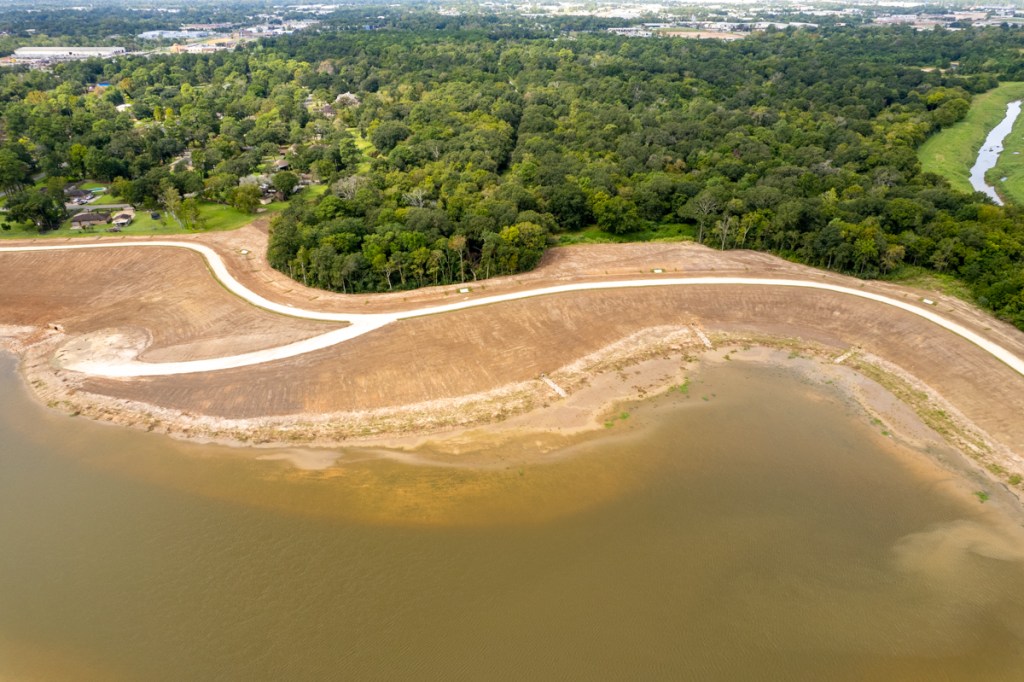
9/29/25 – Harris County Flood Control District (HCFCD) recently completed Phase 2 of the Lauder Stormwater Detention Basin on Greens Bayou. The basin is located south of Intercontinental Airport between the bayou, Aldine Bender Road, Aldine Westfield Road and Lauder Road. It brings the total stormwater detention in the area to 1200 acre feet and Phase 3 is still to come.
Flood Control District Map not yet updated. Phase 2 is now complete.
Speaking at the dedication ceremony for Phase 2 on 9/17/25, HCFCD Executive Director Tina Petersen said, “The scale of this project is enormous. We have three different phases. Phase one was started in 2020, and it took two years to complete. This project started in 2022, and we completed it just this year in 2025.”
Flood Protection Plus Recreational Amenity
Petersen added, “One of the great things, too, is that we are able to partner with our precinct (Harris County Precinct 2), and they have been able to put trails along the first phase, and they are in the process of planning trails for this next phase. And so, not only will it provide flood mitigation, but it’s going to provide an amenity for this community.”
How much is 1200 acre feet? Imagine a football field stacked with water to the height of 1200 feet. That’s 200 feet taller than the tallest building in Houston and Texas – the JP Morgan Chase Tower which tops out at 1002 feet.
Resident in Alleged “500-Year Floodplain” Flooded 3 Times
At the dedication, Connie Esparza, President of the Castlewood Civic Club said, “What a great day to witness and be a part of this historic event. I moved to the Aldine area in 1979 when I built my house, never expecting to flood since the south side of Castlewood was in the 500-year floodplain.”
She continued, “But unfortunately, I, along with my entire subdivision, some of whom are present here, flooded in 2001 with Tropical Storm Allison, then again with Harvey in 2017, followed by Imelda two years later. We are certainly excited with the completion of this Phase 2 stormwater detention basin that will further reduce the risk of flooding.”
Esparza is also a member of the Harris County Community Flood Resilience Task Force.
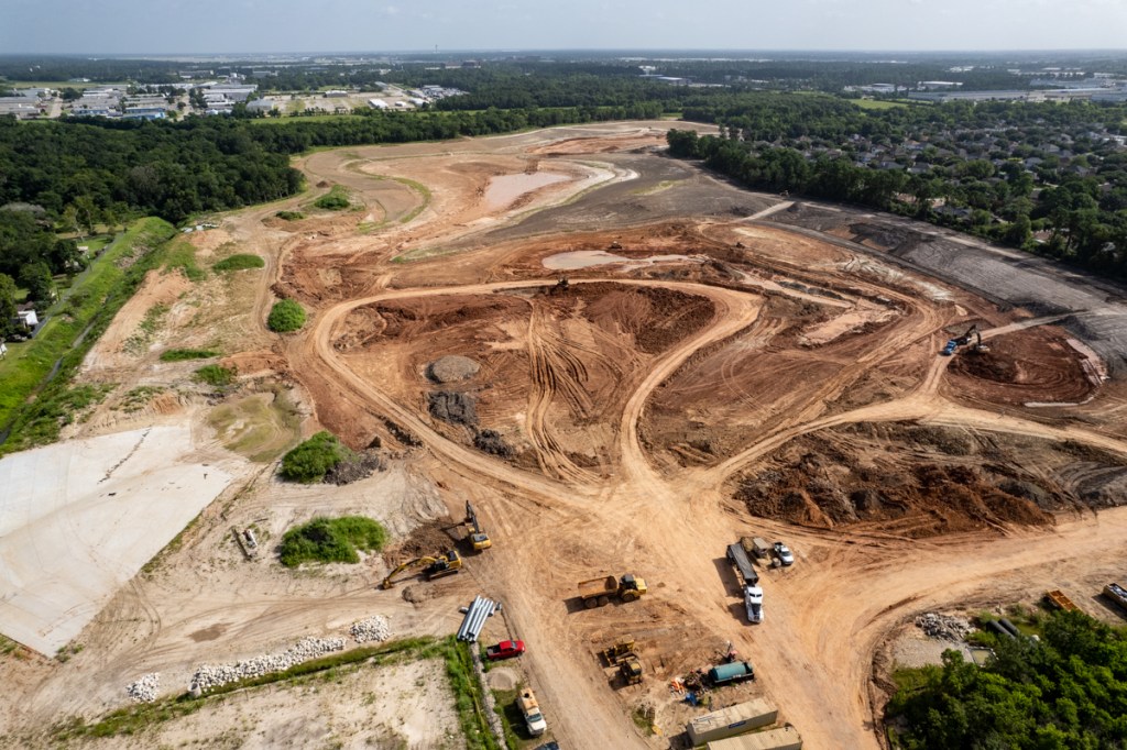
The long-awaited Lauder Basin Phase II on Greens Bayou is now under construction. In May of last year, the Texas Water Development Board announced a $2.2 million grant to expand the basin.
HCFCD is expanding the basin into the old Castlewood Subdivision east of Aldine Westfield Road.
A visit to the job site earlier this week showed that construction is now well underway. See the photos below.
Looking NW.Phase II of the Lauder Basin under construction. Greens Bayou is in upper right. Small creek in foreground is a tributary.
Looking West. Greens Bayou flows toward camera position from upper right to lower right.Still looking west, but from closer position reveals that HCFCD is excavating area closest to Greens first.Looking West from farther away reveals proximity of Phase II with two ponds built during Phase I.See diagram below.
Eventually, Phase 2 should have several compartments with water-quality plantings to help filter out pollutants, and a small stream connecting the ponds. This presentation is a bit dated, but shows HCFCD’s plans for the basin as they existed in 2020.
Artists rendering of Phases I and II of Lauder Basin.Plans for Phase II have reportedly changed slightly.
Project Scope
Together, Phases I and II should provide more than 1,200 acre-feet of stormwater storage. HCFCD designed them to fill up during storms to help reduce the risk of Greens from flooding local homes, businesses and schools. After a flood, the basins release excess water slowly when the channel can safely accept it.
Phase II (651 acre feet) will actually provide more stormwater storage than Phase I (588 acre feet).
HCFCD estimates total Phase II construction costs at $32 million and predicts construction could take 2.5 years.
Spending Comparison with Other Watersheds
Greens Bayou has received more than a quarter billion dollars of projects such as these since 2000. That’s more than any other watershed in Harris County with the exception of Brays Bayou – where Commissioner Rodney Ellis lives.
Data obtained from HCFCD by FOIA request. Includes all spending from 1/1/2000 through end of Q1 2023.
Greens Bayou is one of the few watersheds where HCFCD spending did not plummet last quarter. Even as spending decreased in 15 watersheds, it rose in Greens Bayou by almost $4.8 million. To put that in perspective, it increased 11 times more than the watershed with the second largest increase, White Oak, at $431,126.
Here are the actual numbers.
Data obtained from HCFCD via FOIA requests.
No doubt, the activity you see in the photos above had a lot to do with Greens’ ranking. So, does construction on Garners Bayou, a tributary of Greens farther downstream.
Stay tuned for more news as construction progresses.
Posted by Bob Rehak on 5/12/23
2082 Days since Hurricane Harvey
https://i0.wp.com/reduceflooding.com/wp-content/uploads/2023/05/20230507-DJI_0719.jpg?fit=1200%2C799&ssl=17991200adminadmin2023-05-12 15:59:292023-05-12 16:02:39Lauder Basin Phase II on Greens Bayou Under Construction
Harris County Flood Control District (HCFCD) and its partners continue to add detention basin capacity along Greens Bayou to reduce the risk of flooding. I flew in a helicopter today with fellow Harris County Community Flood Resilience Task Force members Ken Willians and Bill Calligari. We flew over Greens, Halls, Hunting, and White Oak Bayous. In this post, let’s focus on what we found in Greens.
From west to east, we flew over the Cutten Basin at 249 and Beltway 8, then followed the bayou over the Antoine, Kuykendahl, Glen Forest, Aldine-Westfield, and Lauder Basins. Some have recently completed construction. Others are still under construction. Here’s a rundown of everything between US249 and US59 along Greens.
Cutten Basin
Scheduled for completion later this year, the Cutten Basin covers approximately 250 acres. It includes five compartments, four south of Greens Bayou and one north. When complete, it will hold 850 acre feet of stormwater. That’s enough to hold a foot of rain falling across approximately 1.3 square miles. It will lower the water surface elevation along Greens by a third of a foot in a hundred-year flood.
Looking S toward Beltway 8. Greens Bayou flows from right to left through the center of the frame. Looking East. Greens cuts through the upper left portion of the frame. Beltway 8 cuts through the upper right.Looking West across Hollister which cuts through the middle of the frame.
Antoine Basin
HCFCD and the Army Corps started the $80 million Antoine Basin in 2015. The Army Corps designed and built it. Satellite photos in Google Earth first show it holding water in November 2020.
Looking east along Greens toward the Antoine Basin, top right.Looking SW. West Greens Road arcs through center of frame. Greens flows from upper right to lower left. Beltway 8 near top of frame.
The completed basin holds approximately 1,650 acre-feet, or 538 million gallons of stormwater. To put that in perspective, it holds a foot of rain falling over a 2.5 square mile area, or half a foot falling across 5 square miles!
Kuykendahl Basin
Kuykendahl Stormwater Detention Basin sits on a 288-acre property near Kuykendahl Road and Ella Boulevard along an unnamed tributary of Greens Bayou. In floods, it holds water back from entering the bayou and then releases it safely and slowly after the storm has passed.
Wide shot of Kuykendahl Basin looking westKuykendahl in foreground. Note how densely populated the area is with apartments.
Contractors removed 3.61 million cubic yards of soil from the site. It holds 2,325 acre-feet, or 757.6 million gallons of stormwater. That’s a foot of rain falling across 3.6 square miles, or half a foot falling across 7.2.
Following construction, contractors planted 22.19 acres of native tree and shrubs, and 12.79 acres of stormwater quality-treatment wetlands. They also created 14.04 acres of other wetlands to replace those impacted by construction.
Ceres Environmental Services Inc. constructed the Kuykendahl basin and another to the east (see Glen Forest below). Combined, they were the largest construction contract ever managed by HCFCD up to that time. The two basins reduced or removed flooding risks and damages from more than 1,100 structures along Greens Bayou. “Avoided damages” exceed $90 million in every flood. Far more than the cost of construction.
FEMA awarded $39.2 million to the Harris County Flood Control District, under the Hurricane Ike Hazard Mitigation Grant Program (HMGP) to construct the basins and HCFCD contributed matching funds.
Google Earth satellite photos indicate construction finished for both basins in 2020.
Glen Forest
Farther east along Greens, the Glen Forest Detention Basin extends from I-45 to Imperial Valley north of Greens Road.
Looking East across I-45 at Glen Forest Basin.Looking West at Glen Forest Basin on Greens Bayou between I-45 at top of frame and Imperial Valley Drive under camera position.
The Glen Forest Basin project removed approximately 2.15 million cubic yards of soil in three connected cells. The completed basin holds approximately 894 acre-feet. That’s 1.4 square miles one foot deep or 2.8 square miles a half foot deep.
Aldine Westfield Basins: Phases 1 and 2
Farther east along Greens Bayou, directly south of Houston’s Bush Intercontinental Airport, you will find two more new basins. HCFCD completed construction on the first in April 2021. The second (to the north) then began construction and has not yet finished.
Looking East from over Aldine Westfield Road in foreground at Phase One. Beltway 8 in upper right. Note Greens Bayou turning south under Beltway in upper right.Looking ENE. Phase 2 is still under construction on Aldine-Westfield Road immediately north of Phase 1 (lower right). Note airport tower on horizon.
The two basins when complete in 2024 will hold a foot of rain falling over more than 2 square miles (1260 acre feet). That concludes your helicopter flight down Greens Bayou for today.
Greens by the Numbers
Together, these basins should hold approximately a foot of rain falling over 12 square miles.
That’s not enough to prevent flooding in another Harvey. But it will certainly reduce flooding for thousands of people. HCFCD has not yet released updated flood-risk data for the mid- and upper reaches of Greens Bayou (shown above). More news on that when it becomes available.
According to data obtained from HCFCD via a FOIA Request, Flood Control and its partners have spent more than $435 million on flood mitigation in Greens Bayou between 1/1/2000 and the end of last year. That includes money spent on all phases of all projects shown above.
Only three other watersheds have received more funding since 2000: Brays, White Oak and Sims. But more on those later.
Greens was the second most heavily damaged watershed in five major storms (Allison, Tax Day, Memorial Day, Harvey, Imelda). Those storms damaged more than 29,000 Greens structures.
58% of the population of Greens has low-to-moderate income (LMI). That ranks 6th on the LMI scale of Harris County watersheds.
Last month, the Texas Water Development Board (TWDB) approved a $2,208,906 grant from the State’s Flood Infrastructure Fund (FIF) to the Harris County Flood Control District (HCFCD) for expansion of the Lauder Stormwater Detention Basin.
The detention basin will eventually hold 1,260 acre-feet of stormwater in Aldine along Greens Bayou. The project will help reduce repetitive flooding in that area. It is one of dozens of such projects under construction in the watershed.
“We are extremely thankful for this funding and for the support of the Texas Water Development Board to improve flood resilience for residents in the Greens Bayou Watershed,” said Tina Petersen, Harris County Flood Control District Executive Director.
HCFCD estimates the total cost of Phase 2 will be approximately $20.5 million. The additional capacity in Phase 2 will hold excess stormwater during heavy rain events and then release it slowly back to the channel when the threat of flooding has passed.
Phase 2 will be broken into two compartments.
Compartment 1 will bid later this month. Construction will start later this year and finish in 2024.
Compartment 2 (which TWDB is funding) is currently will be in design until 2023. Construction will begin in April 2024 and complete in early 2025.
Photos of Areas Involved
Phase 1 included a wet-bottom stormwater detention basin, with a permanent pool and features designed to improve stormwater quality.
Lauder Detention Basin Phase 1 on Greens Bayou (right) as of 10/12/2021. Looking SSW toward Lauder Road.
Phase 2 will be a dry-bottom stormwater detention basin with opportunities for recreational development by other entities. It will be in the wooded area (top center) of the photo below.
HCFCD will construct Phase 2 of the HCFCD Lauder Detention Basin in the wooded area (top center) along Greens Bayou (upper right). Looking northwest toward Greenspoint area.
Garcia Lauds Lauder Progress
“Reducing chronic flooding has been my main priority since taking office. This Lauder Stormwater Detention Basin project represents the kind of progress residents expect and need to see, and we are grateful for the Texas Water Development Board’s support in making this critical project possible,” said Harris County Precinct 2 Commissioner Adrian Garcia.
“Making Harris County businesses and homeowners safer from flood events requires a commitment to make smart investments, like the TWDB’s. If we want to see our community thrive, we have to ensure families and companies can confidently grow in areas where their businesses and homes are free from flood fears,” he continued.
Relief from Repetitive Flooding
TWDB Chairwoman Brooke Paup said, “We’re proud to provide grant funding for this much-needed project, which has been a team effort, and to partner with our good friends at the Harris County Flood Control District. The TWDB works diligently to help communities across the state, but it’s especially fulfilling to be a partner in helping an area see some relief after experiencing repetitive flooding.”
Absorbs a Foot of Rain Falling Over 2 Square Miles
The two basin phases will hold at least 1,260 acre-feet, or 391 million gallons, of excess stormwater that might otherwise flood homes and businesses.
Another way to think about that is to visualize water spreading out horizontally. 1260 acre feet would would be a little less than two square miles. (A square mile comprises 640 acres.) So the two basins would hold a foot of rain falling over two square miles!
Looking at the Atlas 14 Rainfall Probability table below, the two phases would hold a 24-hour, 25-year rain falling over 2 square miles.
Atlas 14 rainfall probabilitiesfor northern Harris County
Flood-Risk Reduction Status
But the service area for the basins is bigger than 2 square miles. So the ponds won’t be enough by themselves to provide protection in a 25-year flood. That’s when other Greens Bayou projects will help. Together, the projects in the Greens Bayou Mid-Reach Program, when all are complete, should protect residents in a ten-year rain. See 10-year column in table above.
The two phases of the Lauder basin by themselves should reduce the risk of flooding for more than 4,500 structures in the 100-year floodplain. Learn more about the Lauder Basin at www.hcfcd.org/C34.
Overall, the flood bond allocated $280 million for Greens Bayou improvements. So far, HCFCD has spent $104 million in bond funds on those projects. So 63% the planned budget remains.
Posted by Bob Rehak on 5/10/22
1715 Days since Hurricane Harvey
https://i0.wp.com/reduceflooding.com/wp-content/uploads/2021/07/20210724-DJI_0225.jpg?fit=1200%2C799&ssl=17991200adminadmin2022-05-10 13:29:562022-05-10 14:38:35TWDB grants HCFCD $2,208,906 to Expand Lauder Basin
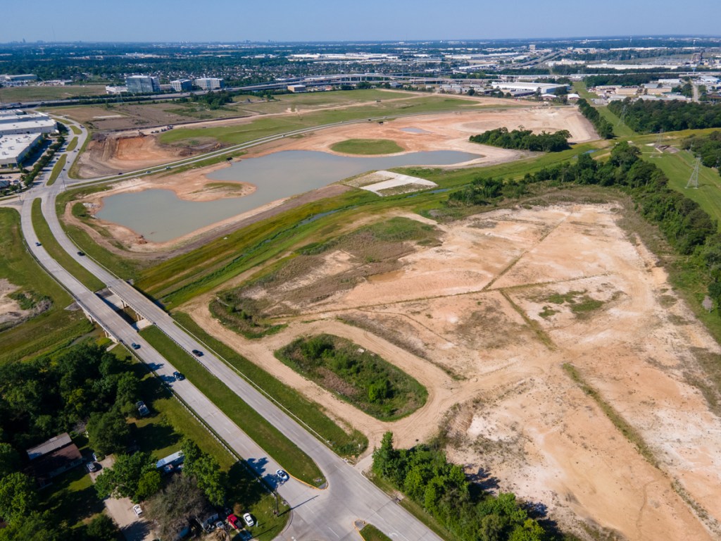
Harris County Flood Control District gave this project the name C34. It’s project ID is P500-06-00-E005. These alpha-numeric descriptions do little to communicate the beauty of this massive pond complex. See below.
Phase I Lauder Basin Photos Taken 10/12/21
Looking south from over Greens Bayou (right).HCFCD contractors have begun to plant grass, but much still remains to plant including trees. Also, the ponds will have aquatic plants that improve water quality.
Looking north from north pond. Culverts will convey stormwater at a controlled rate from ponds to Greens Bayou at top of frame.The cut through the tree line by the bayou appears to be an overflow spillway.
Water flows from one pond into another within the 90-acre complex.
Looking south toward Lauder from north end of pond. That’s JFK Blvd. in the upper left.
Looking south from the Lauder Road entrance to the pond complex in Phase 1. That’s Aldine ISD’s Mead Middle School in the background.Note the drainage ditch running off into the distance and read the caption below.
Looking north from Lauder Road. Notice how water from the ditch above (P138-01-01 in map below) is channeled into ponds now at the lower left instead of going directly to Greens Bayou. Also note excavation equipment being loaded on flatbed trucks for removal.
The Flood Control District has received an $11.5 million grant from the U.S. Natural Resources Conservation Service to help construct these ponds.
Phase II Still Being Designed
The detention basin shown above was purchased by the Flood Control District as undeveloped land in 2000. However, Phase II required buyouts.
Looking west from over Phase I. Phase II when complete will occupy the wooded area in the upper right.Phase 1 is on right (E005), Phase 2 on left (E006). Phase 1 is in its final stages. Phase 2 is still in the design phase. Notice how each pond detains water from long channels before releasing it into Greens Bayou.
Phase II is immediately west of Phase I. It will be located on the property of the former Castlewood Subdivision, Sections 1 and 2. HCFCD completed preliminary engineering for Phase 2 in January 2021. The project is now in the design phase. It is budgeted for $20.5 million and scheduled to start construction in the summer of 2022.
Castlewood was built in the early 1960s in the Greens Bayou floodplain. It was also built in a former floodway of Greens Bayou before the bayou was rerouted and straightened circa the 1950s. Development occurred many years before the advent of Harris County’s first floodplain maps and associated development regulations in the 1980s. Since the late 1970s, there have been more than a dozen recorded flood events in the area.
Together, Phases 1 & 2 comprise more than 200 acres – an area about 25% larger than Kingwood’s largest park – East End Park.
When complete, the ponds in both phases will have enough capacity to hold a foot of water falling across a two-square mile area. That’s water that won’t be going into Greens Bayou immediately during a big storm.
Posted by Bob Rehak on 10/14/2021
1507 Days since Hurricane Harvey
https://i0.wp.com/reduceflooding.com/wp-content/uploads/2021/10/DJI_0535.jpg?fit=1200%2C799&ssl=17991200adminadmin2021-10-14 14:00:432021-10-14 14:04:42Phase I of Giant Lauder Detention Basin on Greens Bayou Nears Completion
By the time Phases I and II are complete, the detention ponds will hold 1,600 acre-feet of of stormwater. That’s enough to hold a foot of rain falling across two and a half square miles.
According to HCFCD’s website, construction on Phase I should finish by the end of this year. Phase II should start next year. The two projects have a combined budget of $38.5 million.
If you don’t believe the Flood Control District website, check out Google Earth, or the satellite views in Google Maps and Apple Maps. This project is so big, you can see it from outer space.
Satellite image from Google Earth taken on 11/16/2000. Phase I construction has advanced considerably since then. See below.
The following photos were all taken on Sunday, 7/25/2021, around noon.
HCFCD Lauder Detention Basin Phase I. Looking north across Lauder towards Greens Bayou in background and Bush Intercontinental Airport in distance.NE corner of HCFCD Phase I Lauder Detention Basin, looking east towards JFK Blvd, just south of Greens Bayou.Looking south from over Greens Bayou toward Lauder and the Aldine ISD Mead Middle School in distance.HCFCD Lauder Detention Basin on Greens Bayou. Excavation is now focusing on the pond closest to Lauder in the distance.When I last photographed this basin in April, the area for that last pond was being cleared.Phase II will be built in the wooded area beyond the current Phase I construction.
Still Don’t Believe the Project Exists?
Think the photos are some kind of Photoshop trick? Visit the site yourself. Construction is bustling. On Sunday, around noon, I watched dozens of trucks coming and going while I took the photos above. Here’s how to get there.
Lauder Detention Basin location
Counterfeiting the Currency of Communication
The bizarre thing about this project is that the politicians who say it doesn’t exist are the ones who funded it. Go figure. Such is the sad, sorry state of politics in America today.
I’ve even talked to professors, professional engineers, MBAs, and PhDs in engineering who claim this and similar projects in Halls and Greens Watersheds don’t exist!
Worse yet, they refuse to look at the pictures, go to the construction site, review Flood Control’s website, or trust audited county spending data.
Language is the currency of communication. It’s how we cooperate. How we get things done. It’s one thing to disagree over project priorities. But another to claim projects don’t even exist when they do.
As a consequence, public policy has become divorced from reality. This is worse than being duped by misinformation. It’s the unwillingness of people, even including some journalists, to review available information that helps the public make informed decisions. And it doesn’t bode well for your region.
Posted by Bob Rehak on 7/28/2021
1427 Days since Hurricane Harvey
https://i0.wp.com/reduceflooding.com/wp-content/uploads/2021/07/20210724-DJI_0232.jpg?fit=1200%2C799&ssl=17991200adminadmin2021-07-26 22:35:482021-07-26 23:42:17Lauder Basin: Another Flood-Mitigation Project that Doesn’t Exist According to Some
One of the largest watersheds in northern Harris County is Greens Bayou. It drains 212 square miles with a population of more than half a million people. It encompasses portions of the cities of Houston and Humble.
Greens Bayou and its tributaries have flooded homes and businesses numerous times in the last two decades. Tropical Storm Allison in 2001 and Hurricane Harvey in 2017 produced devastating floods thanks to large floodplains and high-density development.
An Equity Priority
As a result of high percentages of low-to-moderate income neighborhoods as you work your way east and south along the bayou, flooding in Greens received a high priority in the Harris County’s Equity Prioritization Framework.
Harris County Flood Control District currently has three projects in construction along Greens Bayou with more on the way. One of the three is virtually complete. When I photographed it today, I found contractors doing a final inspection. Here’s a rundown of current and future projects.
Greens Bayou runs roughly parallel with the North Belt before turning south and eventually joining Buffalo Bayou. Projects 1 and 3 are large scale detention projects under construction. Phase 1 of Project 2 is virtually complete.
Project #1: Cutten Stormwater Detention Basin
HCFCD is currently excavating a massive 235-acre stormwater detention basin near Cutten Road and State Highway 249. It will reduce flooding risks in the Greens Bayou watershed by taking in excess stormwater during heavy rain events and then releasing it slowly back to the bayou when the threat of flooding has passed.
The project is budgeted at $16.2 million. And it is approximately one-quarter complete. I took the pictures below on 4/20/21.
Looking SW at the Cutten Basin with the Beltway 8/SH249 intersection in the background. Greens Bayou flows diagonally from the upper right to lower left.Tunnels under Greens Road will let water flow from the northern section to southern Looking NE across Hollister Road toward another section of the basin that will connect to the rest via tunnels.A relentless carousel of trucks carries away one layer of the basin after another.
Further down the bayou, the Aldine Westfield Stormwater Detention Basin is located just north of Beltway 8 and east of Aldine Westfield Road. The first phase of this project is virtually complete. It sits in a no-fly zone for drones because of its proximity to Bush Intercontinental Airport. So you will have to make do with a ground-level construction photo stitched together in Photoshop from five separate exposures.
Looking SE at Phase One of the Aldine Westfield Basin. Contractors have just finished planting trees to stabilize the slopes.Phase Two has yet to start. It will be to north (left) of this basin.Phase One has just completed. Phase Two is in permitting.
South and north segments are being constructed in two phases because of environmental permitting. Eventually, the two basin compartments will connect via a 48-inch pipe and will outfall into Greens Bayou.
The first phase above cost $7.7 million. The second will cost $11.3 million.
Because of the location just south of Bush Intercontinental Airport, this basin will not have a permanent pool. Reason: to avoid attracting waterfowl which could create a hazard to aviation.
The two basins will eventually hold approximately 1,250 acre-feet, or more than 407.3 million gallons, of stormwater that otherwise might flood homes and businesses during heavy rain events. The benefits of this project are best understood as part of a suite of projects – Progress Greens – that will work together to reduce flooding risks within the 213 square miles of the Greens Bayou watershed.
Part of Project Greens
Project Greens is a suite of flood damage reduction projects. The Harris County Flood Control District is taking the lead in some, with grant assistance from the Federal Emergency Management Agency (FEMA). In others, the U.S. Army Corps of Engineers will design and construct the project, with partnership assistance from the Flood Control District.
All projects under the Progress Greens umbrella will function together to reduce flooding risks and damages for residents and businesses within the 213 square miles of the Greens Bayou watershed.
The Aldine Westfield Stormwater Detention Basin project is and will be funded both through the Flood Control District’s Capital Improvements Program and the 2018 Bond Program. If partnership funds are not available, the project will be funded totally from the 2018 Bond Program as a “Local Only” project.
Project #3: Lauder Stormwater Detention Basin
The Lauder Stormwater Detention basin is another 2-phase project. Phase One, just north of Lauder Road and west of JFK Boulevard, will cost $18 million when complete. Phase Two will cost another $20.5 million and be located west of Phase One in parts of the Castlewood subdivision which HCFCD has bought out. Harris County Commissioners Court accepted the Preliminary Engineering Report and authorized the design and construction of Phase Two of the stormwater detention basin.
The photos below show the status of Phase One.
When complete, the Lauder Stormwater Detention Basin will hold at least 1,200 acre-feet, or more than 391 million gallons of excess stormwater. According to HCFCD, the project will reduce risk in more common 10 percent (10-year) floods, but would be overwhelmed in a much larger storm.
While driving around this area, I noticed a new home ten-feet up on stilts, while older homes sat at ground level. Commercial and industrial development around Bush Intercontinental Airport has literally swamped this area. This Lauder Basin is also part of Progress Greens.
The photos below show the status of Phase One construction on 4/20/21.
Looking north from the construction entrance at Lauder Road.Looking East at the Lauder Basin construction staging area.
The Lauder Stormwater Detention Basin project is being funded both through the Flood Control District’s Capital Improvements Program (for design) and through the 2018 Bond Program (for construction).
Total Cost for Greens Bayou Projects in Construction
Altogether, construction of these three projects will cost approximately $42 million. Phase Two of Aldine Westfield and Lauder basins will cost another $31.8 for a total of almost $74 million. Phase 2 of the Aldine Westfield construction will kick off this summer. And Phase 2 of the Lauder project will start next winter.
Posted by Bob Rehak on 4/29/2021
1330 Days since Hurricane Harvey
https://i0.wp.com/reduceflooding.com/wp-content/uploads/2021/04/20210420-DJI_0429.jpg?fit=1200%2C900&ssl=19001200adminadmin2021-04-20 17:17:452021-04-20 17:54:37Construction of HCFCD Greens Bayou Flood Mitigation Projects in High Gear