They Clearcut 533 Acres, Then Got 17 Inches of Rain
Construction is always the riskiest period during a development project. Especially when you clearcut 533 acres and get 17 inches of rain … in a week. However, thanks to best practices and luck, most people surrounding the Sila development in Huffman narrowly escaped what could have become a major disaster.
As the people in Woodridge Village learned repeatedly on far less rain, best practices can make all the difference. They lived near a development where stormwater detention basins were not built before the rain; the people near Sila did.
The new 553-acre Sila Project in Huffman on the East Fork of the San Jacinto seems to have had considerably less impact on neighbors. This is a story of people caught between a rising river and sheet flow coming down a slope.
Sila’s Similarities, Differences with Woodridge
Several similarities with the Woodridge project exist. Sila is big. Built on an identical slope. And clearcut. But after 17 inches of rain last week, the outcome was dramatically different.
Instead of flooding hundreds of homes below the development as Woodridge did, most residents near Sila only got water in their yards. One fish pond was ruined. At least two vehicles flooded. And at least one garage flooded.
The big differences between Sila and Woodridge?
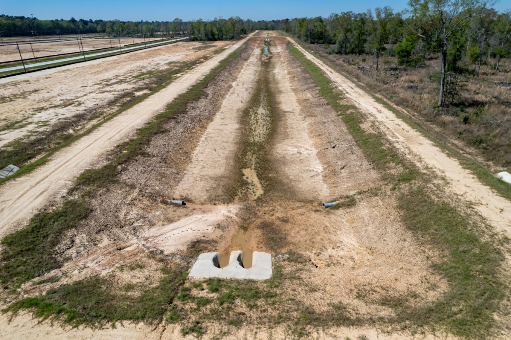
Sila had already built stormwater detention basins. When the rain hit, a series of berms and ditches helped funnel runoff to the basins and away from neighbors. Silt fences intercepted much of the runoff. And crews replaced the fences when silt started to spill over the top.
Before looking at pictures, first let’s look at some stats that put the rainfall in perspective.
5- To 25-Year Rainfall
After Sila weathered this year’s January rains, it got slammed again in the week between April 29 and May 5 with almost 17 inches of rainfall.

That included 7 inches in one day. And half of that fell in one hour.

NOAA defines a 7-day/17.1 inch rain in this area as a 25-year rainfall. Ditto for a one-hour 3.88 inch rain. Seven inches in one day, however, is only a 5-year event.

However, the East Fork peaked at FM1485 at a level equal to a 500-year flood according to Harris County Flood Control’s Flood Warning System. That’s because even heavier rain fell upstream in less time. It then reached FM1485 when heavy rains were falling there.


Also, according to HCFCD, to date, the area near FM1485 has received more than two thirds of a year’s average annual rainfall in about one third of the year – 34.72 inches!
Pictures Taken During Week of Heavy Rains
Northwood Country Estates resident Max Kidd provided many of the following photos taken at ground level during the flood.
They show mainly severe street flooding. Thankfully, Harris County Precinct 3 Commissioner Tom Ramsey’s crews had just finished cleaning roadside ditches. Otherwise these photos might have told a much worse story.

On 5/3 and 5/4/24, Kidd took these photos.


Kidd believes the home above likely flooded from the East Fork. However, Sila runoff may have added to the flood depth.
Photos Taken After the Storm
Sila is so big that it’s hard to get it all in one shot. The aerial shots below were all taken on 5/6/24 after the rain ended.


In the photo below, also note the forested corridors that break up Sila runoff. While large portions have been clear cut, those that haven’t help retain sediment.


As I left after this photo session, I noticed workers replacing and reinforcing the silt fence above. But the photo below shows the volume of the sediment that escaped despite their efforts. A lot!


No doubt, several sources contributed to the discoloration. They include Sila, other upstream developments, sand mines and natural, river-bank erosion.
Few developments that I have observed go to as much trouble to control runoff as Sila. And few bother to leave trees these days. I wish more did. We might have less sediment clogging our rivers and contributing to downstream flooding.
Posted by Bob Rehak on 5/9/24
2445 Days since Hurricane Harvey
The thoughts expressed in this post represent opinions on matters of public concern and safety. They are protected by the First Amendment of the US Constitution and the Anti-SLAPP Statute of the Great State of Texas.