December 2019. Pipelines exposed by erosion at LMI River Road Mine.
Readers filed complaints with the Mine Safety Administration. And soon, contractors started working on “a fix” for the problem, which had lingered for years. Repairs began in January. Then, in March 2020, I wrote about about completion of the repairs.
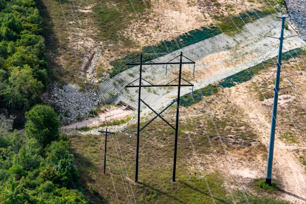
March 2020. Repairs included the installation of two culverts under pipelines and a concrete swale on top of the culverts.
The Warning Two Years Ago
But after looking at all the sediment spewing from the culverts, I warned that “one has to worry about them becoming clogged with sand and silt.” Below, see what the area below outfall looked like at the time.
At the time I captioned this image with “A big issue in the future may be sediment clogging the culverts.“
Today, Culverts Almost Totally Blocked
Today, the culverts look like this (see below). I took the images below on 7/22/22.
Culverts’ intakes almost totally blocked by sediment. Mine has not maintained them. Water flows from part of the mine on the left to another part on right.
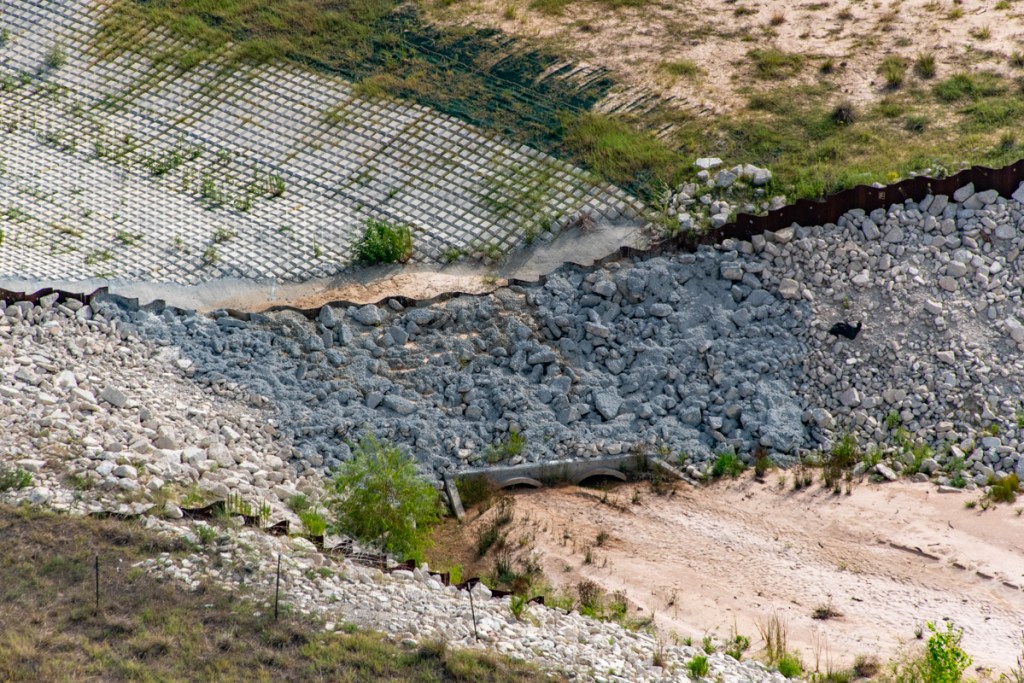
Below, see how the culvert outfalls have also become clogged.
Outfall on West Fork side of culverts.Wider shot. Note how more erosion is beginning on either side of the concrete repairs.
Repeat of Headward Erosion
The shot above illustrates the same type of headward erosion that started causing the safety problem in 2014.
Satellite image of same area from April 2014
Is There A Long-Term Fix?
Short of maintaining one’s property to protect public safety, I’m not sure what the long-term solution is. In my opinion, the first obligation of these mines should be public safety. But that often seems like an afterthought.
Neighbors tell me that this mine no longer operates every day. Perhaps the owner, Liberty Materials Inc., is experiencing reduced demand for its product due to economic conditions.
Regardless of the reason, this problem illustrates the need for the TCEQ to stiffen abandonment procedures for sand mines. The thought of those pipelines rupturing highly volatile liquids during a future flood scares me. It should scare anyone who lives along the San Jacinto. What will happen when LMI is no longer here to maintain those culverts?
Posted by Bob Rehak on 8/1/2022
1798 Days since Hurricane Harvey
The thoughts expressed in this post represent opinions on matters of public concern and safety. They are protected by the First Amendment of the US Constitution and the Anti-SLAPP Statute of the Great State of Texas.
https://i0.wp.com/reduceflooding.com/wp-content/uploads/2022/08/20220722-RJR_0226.jpg?fit=1200%2C800&ssl=18001200adminadmin2022-08-01 17:36:232022-08-01 17:57:24Pipeline Repairs at LMI River Road Mine Need More Repair
To shine a light on the difference between the myth and reality, I’ve taken up a new hobby: sand-mine photography from a helicopter. On my December flight up the West Fork of the San Jacinto, I flew over this mine. Note the wetlands and utility corridor in the middle. Also note the trench leading through the trees on the right to that open gap in the tree line along the utility corridor.
I was curious about that gap. So I asked the pilot to go closer and got the photo below. How strange, I thought! The pipeline corridor has washed out, like at the Triple PG Mine. But this was a little different. The mine appeared to be draining the wetlands. Note the river of muck in the photo below.
Enlargement Shows Makeshift Supports
Someone had rigged “supports” under five pipelines. See the enlargement below. I put supports in quotes because they don’t seem to be working very well; note the sagging. Some look more like clotheslines than pipelines under pressure.
Pipelines Carry Highly Volatile Liquids
Investigation showed this is the SAME utility corridor bisecting the Triple PG mine miles to the southeast in Porter. These are the same five pipelines carrying highly volatile liquids (HVL). This mine, however, lies on the West Fork of the San Jacinto in Conroe near 242.
The channel under the five pipelines is up to a 100 feet wide.
Historical Images in Google Earth Show How This Happened
An investigation of historical satellite images in Google Earth shows that erosion has been a problem in this area at least since 1995 – the date of the earliest available image. Water overflowing the wetlands tried to make its way to the river on the other side of the utility corridor. The problem was manageable, however, as long as the land was flat. That was until 2014.
In 2014, when the mine first started excavating next to the corridor, a process called headward erosion started. Water flows from top to bottom. Notice how much deeper and wider the erosion is below the corridor than above. See explanation below.
In 2014, two things happened. The mine started excavating right up to the edge of the pipelines (just as Triple PG did).
Next, three back-to-back-to-back monster storms in 2015, 2016 and 2017. They were “perfect storms” where the right combination of circumstances came together: Heavy rain. Exposed, loose soil. Steeper gradient.
How “Headward Erosion” Happens
The fact that miners had excavated up to the pipeline corridor with some very deep pits created a steep drop at the edge of the pipelines. That meant water crossing the corridor tended to accelerate and erode the sandy soil beneath the pipelines faster. The soil then sagged into the pit, much as you see in the pictures above. This process is well documented and has a name: headward erosion.
Here’s an illustration of how the process of headward erosion works
Trying to make the best of a bad situation, it appears that either the miners or the pipeliners tried to shore up their pipelines with supports. But it’s not working. They keep trying to plant grass. They keep using erosion control blankets. The supports keep sinking. And the pipelines keep sagging. Here’s an even bigger blowup.
It looks as if some of these supports are anchored in quicksand. Notice the extreme difference in their heights. The cross braces supporting the weight may be adjusted as the supports sink. But not on this day.
Another factor here: What if a tree washes down this chute during a torrential rain? It happens. Regularly.
I have a hard time imagining the stress on these pipelines. An engineer calculated a range of weights for me. He made some assumptions about the thickness of the pipes and the weight of liquids inside them. Then he calculated the weight of 100 feet. The range: 20,000 to 30,000 pounds. No wonder they’re sagging. That’s more than I weigh after a dinner at Carrabbas!
Probably No Imminent Danger, But Just in Case…
They’re probably not an imminent danger. But what happens in the next big storm? We’re overdue. It’s been more than two months!
Hundreds of thousands of gallons of flammable liquids. Under high-voltage electric lines. Pipes under stress. Erosion that widens with every storm. This should be a wake up call. But…
Posted by Bob Rehak on 12/9/2019 with help from Josh Alberson
832 Days after Hurricane Harvey and 80 since Imelda
The thoughts expressed in this post represent opinions on matters of public concern and safety. They are protected by the First Amendment of the US Constitution and the Anti-SLAPP Statute of the Great State of Texas.
https://i0.wp.com/reduceflooding.com/wp-content/uploads/2019/12/Sagging-Pipelines.jpg?fit=1200%2C648&ssl=16481200adminadmin2019-12-08 21:45:292019-12-09 21:58:51Don’t Dig Near Pipelines: A TACA Safety Moment