Tag Archive for: Flood watch

Flood Watch, Warning Continue; May Be Extended

7/25/24 Noon – A flood watch and warning continue for the Lake Houston Area with more heavy rain expected. The San Jacinto East Fork and West Fork, Caney Creek and Lake Creek are all at or near flood stage due to even heavier rains earlier in the week.

Flood watches and warnings have been extended until late tonight and “may need be extended into Friday,” according Harris County Meteorologist Jeff Lindner.

Both Lake Conroe and Lake Houston remain well above normal levels and are discharging water.

It’s been a wet year so far. Rainfall year to date is 57% higher than normal at Bush Intercontinental Airport. And while the tropics are currently quiet, sea surface temperatures remain well above average for this time of year.

See more details below.

San Jacinto East Fork

The worst flooding seems to be along the East Fork where water is into the moderate flood stage and still rising. NOAA predicts it will crest at 63.7 feet tomorrow.

Farther upstream at Cleveland, the Fire Department has warned of flooded low-water areas. But the river appears to be cresting.

Caney Creek near Splendora

Caney Creek near Splendora has peaked inches below the moderate flood stage and should start decreasing today.

Lake Creek Above the Woodlands

Lake Creek above The Woodlands is also flirting with flooding due to more than 10 inches of rain in the last three days. However, barring more heavy rainfall, the creek should now recede.

West Fork at US59

All the water that fell near The Woodlands is now working its way downstream to the Lake Houston Area. Minor lowland flooding last night is now receding.

Lake Conroe

The level in Lake Conroe is finally going down, but the SJRA continues to release more than 5,000 Cubic Feet per Second (CFS).

The SJRA reported a level of 201.88 earlier this morning.

Lake Houston

Lake Houston is 1.6 feet higher than normal and discharging 32,435 CFS. Ten thousand CFS can go through the existing flood gates. The rest is going over the spillway.

Rainfall Prediction

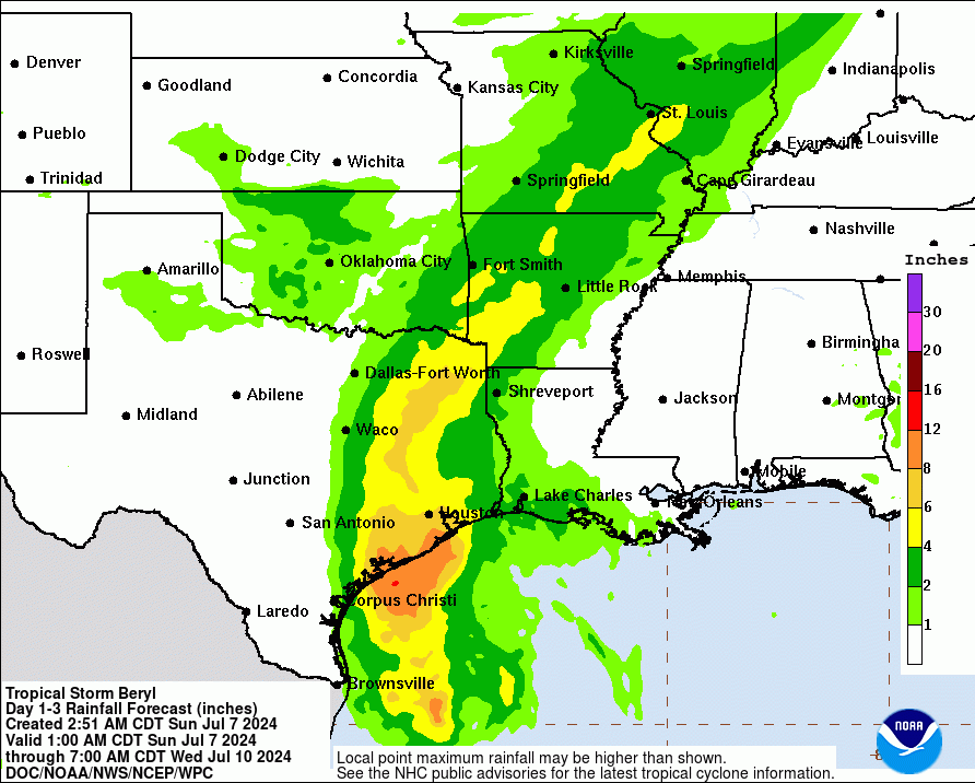
The National Weather Service predicts 3-6 inches of rain along the coastline, 2-4″ inches up to I-10, and up to 1.5 inches farther inland.

I’ve already received more than an inch in my rain gage so far today.

Flood Watch Remains in Effect

As a result of more rain falling on ground saturated by heavier rainfall earlier in the week, a Flood Watch remains in effect for Harris, Liberty, Galveston, Chambers and Fort Bend counties.

Rainfall Year-to-Date

So, how does all this rainfall compare to a normal year? The National Weather Service shows this graph for Bush Intercontinental Airport.

Normally, by this day in July, we get around 28 inches of rain. But year to date, we have received 44.27 – 57% more than normal – quite a change from last year’s drought.

Tropical Outlook

The National Hurricane Center currently shows no areas of interest in the Atlantic, Caribbean or Gulf of Mexico. That’s good news. And they expect none for the next seven days – even better news.

However, forecasters warn that that could turn around in early August. Sea surface temperatures remain well above normal for this time of year.

The main development region between West Africa and the Caribbean remains 1-3 degrees Celsius above average. That translates to 1.8 to 5.4 degrees on the Fahrenheit scale.

So remember to keep those storm drains clear of debris from Beryl! And keep those floaties handy!

Posted by Bob Rehak on 7/25/24

2522 Days since Hurricane Harvey

Tropical Storm Warning, Flood Watch for Inland Harris County

7/7/24, 10:30 AM – The National Weather Service (NWS) and FEMA have issued a tropical storm warning that includes Houston, Kingwood and Spring.

Beryl is moving closer to the Texas Coast and turning a little more northward. Although it has not yet re-intensified into a hurricane, the National Hurricane Center predicts it will, and that it could even turn into a Category 2 before landfall. The center will likely pass near the west side of Houston.

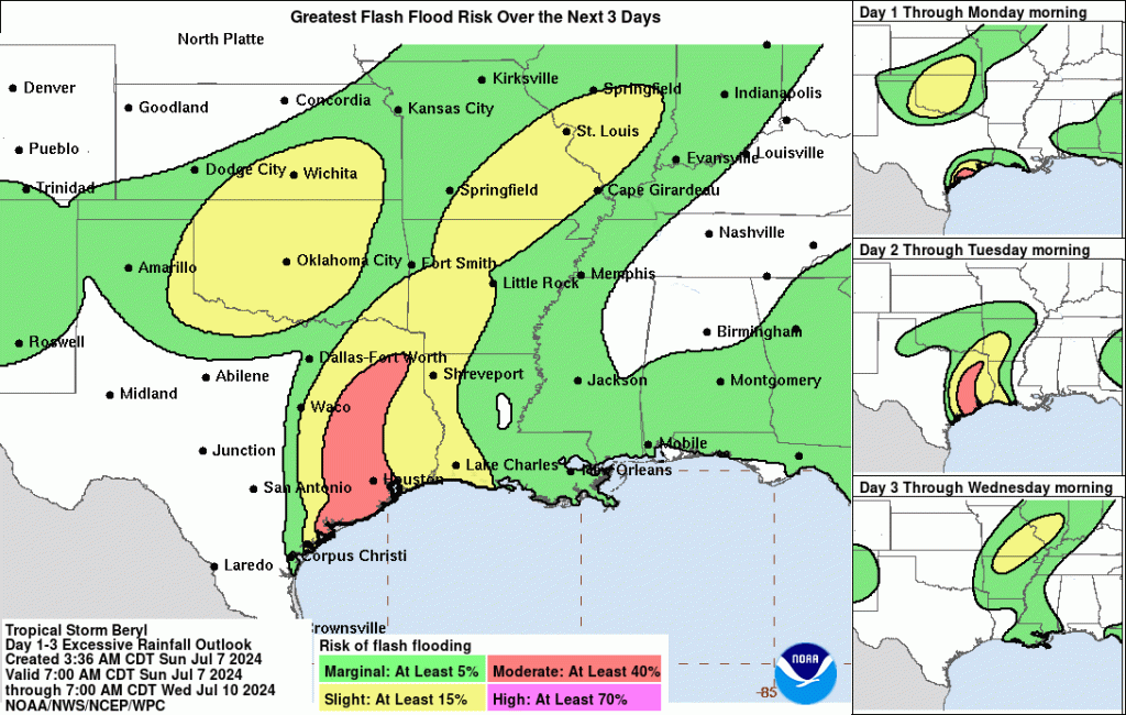
NWS and FEMA have also issued a flood watch that will last until 7AM on Tuesday, July 9. It includes most of SE Texas.

Beryl position at 8:30 AM CDT.  A turn toward the NNW and N is likely today before Beryl reaches the coast.

Tropical Storm Force Winds Expected in North Houston Tonight

Tropical storm force winds could arrive this evening. The high winds will spread inland toward the I-10 corridor by early Monday morning. They should reach the HWY 105 corridor by sunrise Monday.

So authorities urge you to finish hurricane prep as soon as possible.

Re-Intensification into Hurricane Possible

According to Harris County Meteorologist Jeff Lindner, “Beryl is starting to move into more favorable conditions for development and if/when an inner core forms…more rapid intensification will be possible.”

NHC forecasts that Beryl will make landfall at 85mph. However, they also say that winds could reach 100mph.

In inland Harris County, winds could average 45-55 MPH with gusts to 80 MPH.

“There remains the potential for fairly significant intensification of Beryl in the last 12 hours prior to landfall.”

Jeff Lindner, Harris County Meteorologist

Prolonged Power Outages Predicted

Lindner warns the public to be prepared for extended power outages. Widespread power outages are now likely over a large part of the area on Monday.

Downed trees and tree limbs as well as damage to roofs, windows, etc. will all be possible.

Centerpoint issued a press release saying that it is already mobilizing crews.

All outdoor objects should be safely secured by this evening in the hurricane and tropical storm warning areas.

Tropical storm force winds will reach the coast this evening. They will spread inland toward the I-10 corridor by early Monday morning and reach the HWY 105 corridor by sunrise Monday.

Excessive Rainfall and Flooding Potential

Widespread rainfall amounts of 5-10 inches are likely along and to the right of the track of Beryl, with isolated higher amounts under bands where training occurs. Banding may continue into Monday night and possibly Tuesday.

The heaviest rainfall will likely be west of I-45 on Monday. High rainfall rates in bands will produce urban flooding and rapid rises on area creeks and bayous.

Some flooding of creeks, bayous and rivers will be possible with the forecasted rainfall. River responses will continue into mid- to late week.

FEMA’s flood watch lasts through Tuesday morning. It says, “Excessive runoff may result in flooding of rivers, creeks, streams, and other low-lying and flood-prone locations. Creeks and streams may rise out of their banks. Flooding may occur in poor drainage and urban areas.”

Expect street flooding, as well as rises along area rivers, creeks, streams, and bayous.

Other Dangers Near Coast

The National Hurricane Center (NHC) cautions that there is a danger of life-threatening storm surge inundation along the coast of Texas from the north entrance to the Padre Island National Seashore to Sabine Pass. That includes Matagorda Bay and Galveston Bay. Residents in those areas should follow any advice given by local officials and follow evacuation orders.

Expect 4-6 feet of surge in Matagorda Bay and 3-5 feet in Galveston Bay.

NHC also say that rip currents will cause life-threatening beach conditions through Monday across much of the Gulf Coast. Beachgoers should heed warning flags and the advice of lifeguards and local officials before venturing into the water.

Finally, NHC says that a few tornadoes could occur along the middle and upper Texas Coast through tonight, and across eastern Texas and western Louisiana on Monday.

Lake Report

At this moment, Lake Houston is releasing 9,626 CFS…the most the lake’s old gates can release at one time.

Lake Conroe is not pre-releasing any water; the lake is currently 9 inches below its normal level. The SJRA’s models predict that should be enough to handle the expected rainfall north of the lake. Let’s hope they are right.

For the Most Up-to-the-Minute Information,..

Monitor what’s happening near you on the Harris County Flood Warning System.

Track the status of the storm at the National Hurricane Center website.

The National Weather Service is the most reliable source for local weather information and warnings. It also predicts when flood peaks will arrive.

To monitor the status of Lake Conroe levels/releases, visit the San Jacinto River Authority website.

To monitor the status of Lake Houston levels/releases, visit the Coastal Water Authority website.

Posted by Bob Rehak at 10AM on 7/7/24

2504 Days since Hurricane Harvey

Tornado Watch, Flood Warning, Flood Watch In Effect

4:30 PM May 16, 2024 – The National Weather Service has issued a trio of alerts that affect the Lake Houston Area. A tornado watch, flood warning, and flood watch are all simultaneously in effect.

Scene Capture from RadarScope Pro at 4:12PM 5/16/24

Tornado Watch

The three include a tornado watch until 10 PM tonight. The watch includes all counties in the Houston Region and then some.

AUSTIN               BRAZORIA            BRAZOS
BURLESON CHAMBERS COLORADO
FORT BEND GALVESTON GRIMES
HARDIN HARRIS HOUSTON
JASPER JEFFERSON LIBERTY
MADISON MONTGOMERY NEWTON
ORANGE POLK SAN JACINTO
TRINITY TYLER WALKER
WALLER WASHINGTON WHARTON

Update: At 5:50 PM, issued a tornado warning for NW Harris, Austin and Waller Counties. They spotted rotation on radar. The warning will expire at 6PM, but it speaks to the severity of these storms.

Flood Warning

The Weather Service has also issued a flood warning for the San Jacinto East Fork. Predicted crests are increasing from minor to moderate levels near FM1485. This could affect people in Harris, Montgomery and Liberty Counties. Some are still cleaning up from the flood two weeks ago.

Flood Watch in Wider Area

Finally, a flood watch has been issued due to excessive rainfall across the region. This one could trigger flooding on other creeks, streams and bayous. The watch area includes:

Houston-Trinity-Madison-Walker-San Jacinto-Polk-Burleson-Brazos-
Washington-Grimes-Montgomery-Northern Liberty-Austin-Waller-
Inland Harris-Southern Liberty-Coastal Harris Counties

This watch is primarily due to excessive rainfall associated with the approaching storm. It could drop 2-4″ across a wide area, with isolated totals up to 6-8″.

Lake Houston is in the area of highest risk – Level 4 – for excessive rainfall.

National Weather Service (See below.)

Flash Flooding Possible

High intensity rains could produce flash flooding that makes driving dangerous.

The ground is already super saturated from previous rains. “There is just nowhere for the water to go,” said Harris County Meteorologist Jeff Lindner.

According to Lindner, “Widespread rainfall amounts of 2-4″ will be likely north of HWY 105. Isolated totals could reach upwards to 6-8 inches. Amounts will decrease toward the south with totals near the coast less than 1 inch. This will virtually be a carbon copy of the last several rainfall events in terms of location and amounts.”

Lake Report

Lake Conroe was releasing 1590 cubic feet per second until the noon hour today. Then, the SJRA stopped releasing water give the Coastal Water Authority a chance to reduce the level of Lake Houston. Lake Houston continues to release water.

Lake Conroe operators hoped they had enough capacity in the Lake to absorb the expected influx of water. But at 4:30PM, the resumed releasing 1587 CFS.

They also announced that they will “pass through storm water and runoff received in the Upper San Jacinto River Basin until Lake Conroe returns to conservation pool.” (201 feet)

Both lakes just returned close to their normal levels from the floods in early May. However, Lake Houston is still a few inches above normal.

Total inflows into Lake Houston are at 6,627 cfs and outflows are at 8,960 cfs. Lake Houston gates have and will remain open until the gate that is stuck partially open is repaired.

Impact on Sedimentation

Most sediment moves during floods. And the West Fork sure has been piling up sediment lately. KSA just completed a sonar survey in River Grove Park where the Kingwood Diversion Ditch enters the West Fork.

Before the last storm, sand had built up at the mouth so that only about two feet of clearance was available for boats. After the last storm, sand is poking up even closer to the surface…and the river is still about a half foot above normal.

Even with water up about a half foot, you can see sand bars lurking just below surface at the River Grove boat launch.

The City of Houston is getting ready to launch a new $34 million dredging program between Kings Point and FM1960.

DRC/Callan Marine mobilizing for new dredging program south of Forest Cove Pool.

Unfortunately, the new City program won’t include the mouth of the Diversion Ditch. KSA will have to hire its own dredger to keep the boat docks open.

KSA’s dredging interval has gone from 8 to 4 to 2 years. It sure seems as though it would be less expensive if we didn’t have West Fork floods flowing through sand pits.

Sand mine on San Jacinto West Fork near Kingwood

For Real-Time Information

To monitor:

Posted by Bob Rehak on 5/16/24 at 4:30 PM

2452 Days since Hurricane Harvey

The thoughts expressed in this post represent opinions on matters of public concern and safety. They are protected by the First Amendment of the US Constitution and the Anti-SLAPP Statute of the Great State of Texas.

East Fork Homes Flooding, Another Flood Watch Issued

May 1, 2024 – Even as East Fork homes are flooding, the National Weather Service has issued another Flood Watch for the region.

Monday’s Storm Brings Wednesday’s Flood

The stormwater from last Sunday night/Monday morning that’s flooding homes near the East Fork San Jacinto could get reinforcements tonight. Another powerful storm is approaching and will collide with moisture laden air from the Gulf later day.

That caused the National Weather Service to issue another flood watch from 10 PM this evening until Thursday evening for Houston and Harris County.

That same NWS bulletin also says that a flood warning remains in effect for the East Fork San Jacinto near New Caney affecting Liberty, Montgomery and Harris Counties.

Jeff Lindner, Harris County’s meteorologist, warned in his midday report that “Widespread amounts of 2-5 inches are likely with isolated totals of 6-9 inches. High hourly rainfall rates will be likely on the order of 2-4 inches which will produce rapid onset flash flooding.”

Lake Conroe and Lake Livingston Already Taxed to Max

The additional rainfall could overburden already overtaxed watersheds. “There is no capacity at either Lake Livingston or Lake Conroe,” said Lindner. “Additional inflows and run-off will have to pass through the dams’ floodgates.”

Although Lindner expects the heaviest rains to stay north of Harris County, “There is some potential that some of the heavy rainfall reaches into northern Harris County overnight,” he added.

If so, the storm could impact Spring, Cypress, Little Cypress, and Willow Creeks as well as the tributaries in northern Waller and southwestern Montgomery Counties, such as Lake Creek.

Lindner says significant rises will be possible depending on the rainfall amounts and patterns. Flash flooding will be likely where heavy rains occur.

That could deal a devastating blow to homes already flooding along the East Fork.

East Fork Photos Taken Morning of Mayday Flood

Pictures taken this morning between 9 and noon showed roads flooded out and many homes and vehicles already underwater.

TXDoT closed FM1485 at the East Fork/Montgomery County line.
SH99 on left, FM1485 on right.

Streets close to the river also flooded.

Looking S. Casey Road on left flooding from East Fork on right.
Home with flooded vehicles and heavy equipment at Casey and Spaulding.
Flooded homes at Casey and Green.
Cypress Hollow just N of SH99.

I took more than a hundred photos like these this morning. Some people were lucky with the water stopping just feet from their homes. Other people were not so lucky. They will need help.

Colony Ridge, Plum Grove and FM2090

Farther north, I explored Colony Ridge and Plum Grove near FM2090.

One of the main entrances to Colony Ridge where it approaches Plum Grove Road

The water there was already starting to recede. But still, many roads were barely passable. Most smaller vehicles did not brave the water.

Opposite angle, same intersection. Unable to see the sides of the road, traffic tried to stay close to the centerline to stay out of the ditches.
Looking NW over East Fork. FM2090 was still passable, but water lapped at the bottom of the bridge. The East Fork completely flooded the abandoned sand mine (upper right) and swept sediment out of mine.

Ironically, even though I could see my way out of Colony Ridge (from the air), I could not get to FM2090 on the ground because of floodwaters. I had to drive south to SH99 to return home.

Dunnam Road Boat Launch

Back in Kingwood, I called a friend on Dunnam Road. She said her boat launch flooded and that water was lapping at the first house coming up the hill.

Dunnam Road boat launch.
Note water surrounding house adjacent to boat dock. Luckily it did not flood and water is receding as of 4PM.
This young man appeared to be making the most of the flood by giving his daughter a fishing lesson. A neighbor told me he’s been doing that since she was born!

Posted by Bob Rehak on May 1, 2024

2437 Days since Hurricane Harvey