Tag Archive for: flash flood watch

Houston in Bullseye: NWS Predicting Another 4-6 Inches of Rain in Next 5 Days

The National Weather Service released this map around 7 a.m. Houston time this morning. It shows Houston in the bullseye with another 4 to 6 inches of rain predicted in the next five days. Jeff Lindner, Harris County Meteorologist, warns that flash flood watches may be needed by Friday into the weekend.

Houston Area is in the Bullseye and could receive another 4-6 inches of rain in the next five days.

Atmosphere Moisture Levels Support 1-3 Inches Per Hour Later Today

Yesterday’s active weather pushed down toward the coast overnight. The local air mass stabilized by Thursday morning. But afternoon heating and a rapid influx of Gulf moisture favor the development of numerous thunderstorms later today over the region.

Moisture levels in the atmosphere support heavy rainfall with hourly rainfall rates of 1-3 inches per hour possible under the strongest cells. Lindner notes that we saw this yesterday evening throughout the Lake Houston area.

Heaviest Rains Expected Friday

However, the main storm system will begin to move slowly into southwest and west TX on Friday. It will dominate local weather through the weekend, according to Lindner, as several disturbances rotate around around it and feed off the near-continuous stream of rich Gulf moisture over the area.

Expect widespread showers and thunderstorms Friday through the weekend with frequent rounds of heavy rainfall.

Jeff Lindner, Harris County meteorologist

Upper level winds will support cell training over the area this weekend. Flash flooding will be a concern. 

Rainfall Amounts, Impacts

Additional rainfall amounts of 4-6 inches will be possible over the next 5 days. Much of this will fall during periods of heavy rainfall. Isolated totals could be significantly higher under any areas of sustained training. Hourly rainfall rates of 1-3 inches will be possible, which could support rapid street flooding.

Ground Still Saturated

Grounds are still saturated from heavy rainfall in May. And some watersheds are still elevated from the rainfall yesterday evening. Rainfall over the next several days will likely generate run-off into local watersheds resulting in rises. Any areas of sustained heavy rainfall will increase the threat for channel flooding given the delicate groundwater situation currently in the area.

Posted by Bob Rehak on June 3, 2021, based on info from the NWS and HCFCD

1074 Days since Hurricane Harvey

Flash Flood Watch, Flood Warning Extended

Flood Watch through 7 P.M. For Most of Region

The National Weather Service (NWS) has issued a flash flood watch for most of the Houston region. The watch will last through 7 P.M. this evening.

Flood Warning Through Saturday Morning For Smaller Areas

In addition, NWS has issued a flood warning for counties to the west and east of Houston. See map below.

From Weather.gov

NWS predicts minor flooding for East Fork San Jacinto near New Caney affecting Harris, Liberty and Montgomery Counties.

Precautions:

Persons with interests along these streams should keep alert to rising water and take all precautions to protect their property. Do not drive or walk into flooded areas the depth and water velocity could be too great for you to cross safely. Avoid any water covered roads and find an alternate route. Livestock and equipment should be removed from the flood plain immediately. Stay tuned to NOAA Weather radio or other news sources for further updates. Turn around, don`t drown when encountering flooded roads. Most flood deaths occur in vehicles. Additional information is available at www.weather.gov.

Today’s Forecast: More Heavy Rain Probable

According to Harris County Meteorologist Jeff Lindner, “…deep tropical moisture to the west will help create a series of upper level disturbances once again today. The result: scattered showers and thunderstorms that should begin with daytime heating. As a disturbance approaches the area this afternoon from the west, showers and thunderstorms will likely become slightly more organized.”

The air mass over the Lake Houston Area remains capable of heavy to excessive short term rainfall rates. Yesterday, 5-7 inches of rain fell over northeast Harris County in 4-5 hours. 8-12 inches fell over Austin County near Bellville.

Hourly rainfall rates of 2-3 inches per hour were common on Monday and the same air mass is in place today.

Rainfall today will likely average between 1-2 inches over the region, but isolated totals of 5-6 inches will be possible. Short range models indicate areas along and northwest of US 59 could be the prime location today for heavy rainfall. However, much of this will depend on:

  • Where storms develop
  • If and where any training develops
  • If any storms anchor in place.

Grounds are saturated from the recent rainfall. During the last 7 days, that rainfall has averaged 5-7 inches over much of the region with isolated totals of 10-14 inches.

Watersheds are already elevated this morning due to the recent rainfall and ongoing run-off over the area. Additional heavy rainfall will quickly run-off creating new rises.

Bens Branch at Kingwood Drive around 6PM on 5/24/21 after a 4-inch rain. Additional rains today, if heavy, could force creeks like this even higher.

Rapid onset flash flooding of streets and poor drainage areas will be the primary concern today, but should heavy rainfall impact already elevated and swollen watersheds some flooding would be possible. 

We should get a break from the rain Thursday and Friday, but more rainfall could enter the picture by this weekend, driving up rain chances yet again.

It’s been a wet month and will get wetter.

River and Lake Report

From Harris County Flood Warning System at 6:20 AM, 5.25.21.

In the upper right at the highest red icon, Peach Creek at FM2090 is three feet out of its banks. This area has flooded three times this month.

The yellow icon below it and to the right is the East Fork at FM2090. It is still two feet within its banks, but additional rainfall today could cause flooding.

The red icon at the northeastern tip of Harris County is the East Fork at FM1485. It is out of its banks again for the third time this month.

Lake Conroe is up about a half foot and releasing almost 1600 Cubic Feet Per Second.

As of 6:30 am on 5/25/2021

According to the Coastal Water Authority, Lake Houston is almost a foot and a half above normal and still releasing.

From Coastal Water Authority at 5:30 am on 5/25/2021

Posted by Bob Rehak at 6 a.m. 5.25.21 based on information from NWS and HCFCD

1365 Days since Hurricane Harvey

A Breather: Rain Mainly South of I-10 For Most of Day

Today, the Lake Houston Area may finally get a breather from non-stop storms that blanketed the area for the previous three days. That doesn’t mean that we won’t get more rain. And it doesn’t mean flooding is not possible. It just means streams and bayous may get a chance to drain.

According to Jeff Lindner, Harris County Meteorologist, “Light rainfall continues mainly south of I-10 across the area.”

RadarScope Pro as of 10:54AM Houston time shows a large complex of storms to Houston’s south and west. They are moving north but have been dissipating as they move past the I-10 corridor for most of the morning.

Says Lindner, “A complex of thunderstorms is moving well into the NW Gulf. Another moving offshore of south Texas will likely keep southeast Texas stable today with only passing light or moderate rain showers and those will mainly focus south of I-10. Additional showers and thunderstorms will be possible on Thursday and Friday with continued high moisture levels over the area. However, the activity looks more scattered in nature and not as organized or intense as the last 48 hours.”

Additional rainfall amounts of 1-3 inches can be expected over the next 48 hours with the higher totals likely focused south of I-10.

Jeff Lindner, Harris County Meteorologist

Rainfall In This Event Almost Half of Year’s Total So Far

My digital rain gage indicates that we’ve received almost as much rain in the last three and a half days as we have year to date. That’s 138 days.

Here’s a breakdown:

  • Year to date: 23.64 inches
  • March: 1.95 inches
  • April: 4.01 inches
  • May to date: 11.38 inches
  • May 16: 1.22
  • May 17: 5.57
  • May 18: 1.64
  • May 19 so far: 1.22

According to the National Weather Service, the normal cumulative precipitation for May (up to the 19th) is 3.12 inches. And the normal yearly precipitation through today is 16.42 inches. Before this is all over, we could skew those averages a bit. We’ve exceeded the monthly average to date by a factor of two in the last two days!

Two-day rainfall totals for most Harris County gages as of 5/19/2021 at 10AM.

Run-off

Run-off continues from the rainfall over the last 48 hours with widespread totals of 3-5 inches over much of the area and an isolated amount of 8.56 inches in the Huffman area. Here’s how that is affecting local rivers and streams.

Rivers and Stream

Creeks in the northwestern portion of Harris County remain elevated and in some cases near bankfull. So do the middle and upper portions of Cedar Bayou and the West and East Forks of the San Jacinto River. Creeks in the northwestern portion of Harris County will crest and slowly fall this afternoon while rises will continue along the West and East Forks of the San Jacinto River. Peach Creek at 2090 is flooding.

East Fork at New Caney should experience minor to moderate flooding in next five days.
West Fork at 59 should experience minor flooding in low lying areas by Saturday.
Peach Creek at FM290 is already out of its banks according to the Harris County Flood Warning System. As of 11 am, elevation was 99.1. A ten-year flood at this gage is 99.3.

Lake Report

Lake Conroe is at 201.64 feet (normal is 201) at this writing and and releasing 2,665 cubic feet per second. Notice that they no longer have a box for seasonal lowering. They now call that COH (City of Houston) Diversion. It’s not that they have discontinued the seasonal lowering; they’ve just changed the way they account for it, according to Jace Houston, SJRA’s general manager. When the Lake is above 201 and water is inbound as it is now, SJRA is allowed to release water without it coming from the City of Houston’s portion.

When the flood threat has passed, if and when the City calls to resume seasonal lowering, the rate will show up in the COH diversion box. SJRA seems to be trying to lay responsibility for any inconvenience to Lake Conroe boaters at the feet of the City of Houston, which has already been dismissed from the Lake Conroe Association lawsuit.

Meanwhile, Lake Houston is up about a quarter foot so far this morning, despite the flood gates being wide open.

As of noon on 5/19/21
How Lake Houston Levels have varied during the last 7 days. Graph shows up to noon on 5/19.

If rain during the rest of today remains light, SJRA may be able to avoid flooding people upstream and downstream, just as they did on May 1st, when the areas upstream from Lake Conroe received 8-10 inches of rain.

Flash Flood Watch Remains in Effect Through Thursday Morning

In the meantime, a flash flood watch remains in effect for the Houston region through tomorrow morning. Chance of precipitation is 60% this afternoon, going up to 90% this evening. NWS predicts up to 1.25 inches of rain today and up to .75 tomorrow for the Kingwood area.

As of this morning, here’s how White Oak Creek looks from the back yard of Woodstream Forest resident.

Photo from a video courtesy of Donald and Kristi Brown. Taken on 5/19/2021.

Posted by Bob Rehak on 5/19/2021 at Noon based on information from the NWS, HCFCD, Coastal Water Authority and SJRA

1359 Days since Hurricane Harvey

Tuesday AM Rain Outlook: Heating Up, Flash Flood Watch Remains in Effect

A Flash Flood Watch remains in effect through Thursday morning.

A serious flash flood threat remains in place over all of SE TX and much of eastern TX into Thursday.

According to Harris County Meteorologist Jeff Lindner, “After the storms from yesterday, deeper moisture has been pushed toward the coastline and offshore, but will rapidly return today.

A slow moving line of thunderstorms moved through the area on Monday producing generally 1 to 4 inches of rain across the area with localized areas of 6 to 8 inches in Liberty, eastern Montgomery, and northeastern Harris County.

The National Weather Service says that a lull in the precipitation occurred overnight, but the chance for heavy rainfall returns this morning as an upper level disturbance moves through the area. An additional 1 to 3 inches of rain with locally higher totals will be possible today. A stronger upper level disturbance will bring yet another round of heavy rain Wednesday into Thursday with additional rainfall totals of 2 to 4 inches of rain with again locally higher totals possible. Storm total rainfall by Thursday morning will average between 4 and 8 inches with isolated totals possibly exceeding 10 inches. The flood threat will be strongly dependent on where the rain falls and how quickly it falls.

Today-Tonight

Scattered showers and thunderstorms will develop with heating today. But it continues to be hard to pinpoint where storms may develop. By this afternoon, storms will likely begin to approach southeast Texas from the west and northwest. They may also possibly approach again from the northeast or north into the evening and overnight hours. See the satellite photo below.

Satellite image as of about 8 a.m. Houston time this morning.

Wednesday-Early Thursday

An upper level trough will transport extreme moisture into the region along with the jet stream. Models many possible scenarios from slow moving lines to quickly approaching complexes from the west. Regardless, the overall pattern favors heavy rainfall, flash flooding, and severe weather. 

Rainfall Amounts

Lindner expects additional rainfall totals of 4-6 inches over the next 48 hours with isolated totals of 10-12 inches. Much of what falls is going to come in short intense bursts of rainfall, he says, and not spread out evenly over time.

The National Weather Service gives our eastern and northern counties a moderate risk of flash flooding today. The risk area should enlarge tomorrow across the entire region.

Excessive rainfall outlook for today
Excessive rainfall outlook for Wednesday and Thursday.

The orange areas indicate moderate risk. That means a 20-50% chance of excessive rainfall.

River, Stream Report

Run-off continues across the region this morning from the heavy rainfall yesterday. Cedar Bayou upstream of US 90 remains high, but has crested and is slowly falling. Spring Creek is rising as upstream run-off from northern Waller County moves into the mainstem of the creek. Not flooding is expected, but the creek will be elevated through the day. West Fork of the San Jacinto River is rising due to inflow from Spring and Cypress Creeks and will crest later this morning.

Both the SJRA and Coastal Water Authority are releasing water from Lake Conroe and Lake Houston preemptively. However, both lakes remain a few inches above their normal levels at the moment.

Additional rainfall over the next few days will quickly run-off resulting in new rises on area creeks, bayous, and rivers. Some flooding of creeks, bayous, and rivers will be possible.

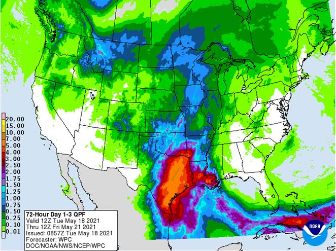
Forecasted Rainfall Next 72 Hours

Predicted accumulations through Friday. Source: National Weather Service

Photo of White Oak Creek from Yesterday

White Oak Creek yesterday flowing near the Woodstream home of Donald and Kristi Brown on Brook Shore Court after a 5.5-inch rain fell on most of Kingwood.

As I write this, the rain has started already this morning. Let’s hope the rain is spread out enough that the creeks can handle it. As predicted, so far it’s coming down in sporadic bursts mixed with light drizzle.

Posted by Bob Rehak on 5/18/2021 based on information provided by the NWS, HCFCD, and Donald Brown

1358 Days since Hurricane Harvey

Two More Rounds of Heavy Rain Yet to Come; Flash Flood Watch Extended Through Sunday

Heavy rainfall remains possible through Sunday

Flash Flood Watch remains in effect until Sunday morning for much of the area.

Widespread heavy rainfall along and north of I-10 over the last 24 hours has resulted in rainfall amounts of 2-3 inches over much of that area. Pockets have received 4-5 inches. Those include northern Waller and western Montgomery Counties. Portions of Walker County received 4-6 inches.

Last 24 hours of rainfall as shown on Harris County Flood Warning System at 7pm 4.30.21.

Ongoing flooding through much of today closed several roads in low lying areas of northern Waller and Walker Counties. Run-off continues to progress down creeks and into mainstem rivers. Rises will continue along upper Spring Creek into tonight and Saturday. However, at the moment forecasters expect no significant flooding. See attached graphics for 24-hr rainfall totals and current channel status.

First Round Kicks Off Overnight

NWS satellite imagery shows moisture streaming up out of Mexico as of 7PM Friday. The area along the middle Texas coast from the coastal bend up to to about Wharton looks favorable for the formation of another round of heavy to excessive rainfall late tonight and early tomorrow. Models indicate this activity will occur mostly west of I-45 and south of I-10 into Saturday morning before it begins to weaken. Exactly how far northeast rain and heavy rain may spread is still in question. But according to Jeff Lindner, Harris County’s meteorologist, “The latest thinking indicates it will remain southwest of the areas hard hit today.”

Second Round of Storms Saturday Night into Sunday

Lindner predicts a weakening of the storm Saturday afternoon. But he warns to expect numerous showers and thunderstorms Saturday evening. He says they will invade the region from the southwest to northeast. Moisture levels will support heavy to excessive rainfall rates within any organized thunderstorms.

Rainfall Amounts

Expect additional rainfall amounts of 1-3 inches over the weekend with isolated totals reaching 4-6 inches…especially around the coastal bend and Matagorda Bay tonight into early Saturday.

Area Soils Now Saturated

I received 3.07 inches in my rain gage today and have standing water in my yard. Soils have become nearly saturated in areas that saw the greatest rainfall today, while areas around Galveston Bay have experienced little rainfall thus far. Heavy run-off in many areas north of I-10 will cause rises in several channels. Keep an eye on the East Fork of the San Jacinto River at FM 1485 into the weekend. The forecast there currently exceeds flood stage.

A good amount of water is routing into the West Fork of the San Jacinto also. But current forecasts keep the river from Conroe to Humble below flood stage. The SJRA is releasing water from Lake Conroe at almost 6000 cubic feet per second. Despite that, the lake level has risen almost a foot and a half today above its normal pool level.

As of 7PM 4/30/2021.

The areas north of the lake received some of the highest rainfall totals this morning. This lake is now 3.5 feet above where it was when the SJRA stopped the seasonal lowering last week. Had they now lowered the lake a foot, it would be even higher now. We can all learn from this experience.

Minor flooding will also be possible this evening along upper Spring Creek west of Hegar Rd with rural low lands near the creek inundated.

Additional rainfall over the weekend may change some of the current forecasts.

Posted by Bob Rehak on 4/30/21 at 8PM based on info from the NWS and Harris County Meteorologist Jeff Lindner

1340 Days since Hurricane Harvey

Flash Flood Watch

The National Weather Service has issued a flash flood watch from 6PM tonight through Thursday afternoon. In the north Houston Area, it includes:

  • Houston
  • The Woodlands
  • Coldspring
  • Trinity
  • Shepherd
  • College Station
  • Huntsville
  • Conroe
  • Livingston
  • Madisonville

The watch extends much farther north and west. It includes the Dallas/Fort Worth Area, Oklahoma, Arkansas where NWS predicts up to six inches of rain.

Where heaviest rains will fall.

Jeff Lindner, Harris County Meteorologist reports increasing risk of excessive rainfall along and west of US 59 and west of SH 288. A strong upper level storm system will combine with increasing moisture and a slow/stalling surface frontal boundary over SE TX tonight. The stalling boundary will produce training.

Lindner adds, “Heavy rainfall of 1-2 inches per hour looks possible and this could be maintained for several hours along/near the stalling front. Where the heaviest rains fall will be determine where the front slows and stalls and at this time areas from Wharton and Fort Bend into western Harris and then northward into Montgomery County have the highest chances.”

“Widespread rainfall amounts of 2-4 inches with isolated totals of 5-6 inches will be possible,” says Lindner. “We need to watch for flooding.”

Areas At Highest Risk of Flooding

While grounds west of I-45 are especially dry, Lindner predicts that the entire San Jacinto basin (west, east, and mainstem) and Trinity basins will be affected – especially in the longer term as water works its way downstream.

Northwest and western Harris County will likely see the highest totals. Responses on the creeks in those areas are likely early Thursday.

Lindner believes most watersheds will be able to handle incoming rainfall up to 4.0 inches. Should western Harris County get more, minor flooding would be possible. Especially along the lower end of South Mayde Creek, the upper end of Little Cypress Creek, the upper end of Spring Creek, and the lower end of Keegans Bayou.  

As of noon on Wednesday, the SJRA shows Lake Conroe at 199.41, slightly below its normal level.

The City of Houston began lowering Lake Houston at noon Wednesday as a precautionary measure. Property owners should secure property along the shoreline. Lake levels can be monitored in real time by visiting the Coastal Water Authority website

Heavy rainfall will end Thursday afternoon.

PRECAUTIONARY ACTIONS

A Flash Flood Watch means that conditions may develop that lead to Flash Flooding. Flash Flooding is a very dangerous situation. You should monitor forecasts and be prepared to take action should Flash Flood Warnings be issued. See:

Do not enter or cross flowing water or water of unknown depth.

Posted by Bob Rehak on 12/30/2020 based on information from the National Weather Service and HCFCD

1219 Days since Hurricane Harvey

Beta Downgraded to Tropical Depression

At 10 a.m. CDT, the National Hurricane Center (NHC) downgraded Tropical Storm Beta to a tropical depression. The NHC also cancelled the tropical storm and storm surge warnings that were in effect. However, flash flood warnings remain in effect for large parts of the seven-county Houston region, especially the southern part. A flash flood watch remains in effect for the entire region.

RadarScope split image. Left half shows track of active storms as of 9:06AM CDT. Right half shows total rainfall accumulation for Beta. Note band of extreme rainfall near Sugar Land and sharp drop-off near Kingwood.

Flash Flood Warnings and Watches

A flash flood warning means that flooding is in progress. A Flash Flood Watch means that conditions may develop that lead to Flash Flooding.

Source: National Weather Service. Updated at 10:29 a.m. 9/22/2020. Reddish area = Flash flood warning. Green = Flash flood watch.

Lake Conroe/Lake Houston Within Banks

Neither Lake Conroe, nor Lake Houston have yet been adversely affected by Beta.

The level of Lake Conroe stands at 199.63 feet. Normal conservation pool equals 201.

According to the Coastal Water Authority, Lake Houston is at:

Lake Level41.41 ft.
Normal Pool42.4 ft.
Source: Coastal Water Authority

USGS shows that even though the lake has received about 1.75 inches of rainfall to date…

…the lake level has been dropping, no doubt due to a preemptive release.

Posted by Bob Rehak at 10:50 on 9/22/2020 based on NHC, NWS, and RadarScope data

1120 Days since Hurricane Harvey and 369 since Imelda

Excessive Rainfall Threat from Beta Spreads Inland

As of mid-day Sunday, all of East Texas now faces some level of excessive rainfall and flash flood risk from Tropical Storm Beta.

The projected path of the storm has shifted inland, so rainfall will reach father north. The latest track now takes the storm on a path right up US59 from Sugar Land to Humble and Kingwood. However, Beta likely be a tropical depression by the time it reaches the north side.

Kingwood is the blue dot next to Spring.

Six to 15 Inches of Rain Now Predicted

According to the local National Weather Service office and the National Hurricane Center, most of the Houston region can expect 6 to 15 inches with the highest totals closer to the coast.

Harris, Montgomery and Liberty Counties (and the whole Houston region) face a high to moderate threat of flooding rains. The first rainbands from Beta have already started to move onshore today, but the heaviest rain will not occur until Monday into Tuesday.

North Houston Under Moderate Flooding Rain Threat

Flash Flood Watch in Effect

The entire region is under a flash flood watch. Coastal areas also face storm surge and tropical storm warnings.

Slow Moving Storm Will Produce Prolonged Rains

Beta is meandering slowly at about 3 mph northwest toward the coastline west of Houston and will then curl back over Houston. It should move inland sometime Monday or Monday night and turn from a storm into a depression by the time it reaches Houston.

However, Beta could dump rain on us from later today all the way through Wednesday.

40-50% Chance of Tropical Storm Force Winds Reaching North Houston

The North Houston Area has a 40-50% chance of seeing tropical storm force winds from Beta.

If the high winds reach this far inland, they would likely arrive Monday evening. Winds extend outward from the center for 195 miles as of Sunday morning.

Feeder Bands Extend Outward 190 Miles

In fact, at 11 a.m. Sunday morning, the first feeder band was approaching the eastern side of Houston, as you can see in the radar image below.

This image shows how the wind and rain from Beta could remain with us for days as the storm’s center wanders around the Gulf.

These feeder bands reach out 190 miles. That is roughly the distance from Houston to San Antonio. So Beta will produce long-duration rainfall from the middle Texas coast to southern Louisiana. 

Flash, Urban, and River Flooding Likely 

The National Weather Service warns that coastal flooding will remain a threat through midweek with the worst of the storm surge anticipated on Monday and Tuesday. 

Elsewhere impacts from the excessive rain include:

  • Rainfall flooding may prompt evacuations and rescues.
  • Rivers and tributaries may rapidly overflow their banks.
  • Small streams, creeks, canals, and ditches may become dangerous rivers.
  • Flood control systems and barriers may become stressed. 
  • Flood waters may cover escape routes. 
  • Streets and parking lots may become rivers of moving water with underpasses submerged.
  • Driving conditions may become dangerous. 
  • Many roads and bridges may close with some weakened or washed out.

Lake-Level Situation

According to the SJRA, Beta has the potential to dump up to 8 inches of rain in Montgomery County

SJRA is operating under standard protocols for a severe weather event and will be onsite at Lake Conroe throughout the duration of Tropical Storm Beta.  

Lake Conroe remains 18 inches low, and based on the current forecast, no reservoir releases are expected. 

SJRA

Real-time information on lake level can be found on the SJRA homepage at the “Lake Operations and Rainfall Dashboard” link.

At of this writing, Lake Houston is down a foot compared to its normal pool level (41.38 vs 42.4). You can monitor Lake Houston levels via the Coastal Water Authority website.

Monitor Downstream River Levels

You can monitor stream and river levels in near-real time at Harris County Flood Warning System. Make sure you check out the inundation mapping feature.

Posted by Bob Rehak on 9/20/2020 based on information from the National Weather Service and National Hurricane Center

1118 Days after Hurricane Harvey

Beta Rainfall Estimates Increasing; 6-10 Inches Now Predicted for Lake Houston Area

Beta has turned toward the Texas coast. Adverse conditions will likely begin Sunday along coast and spread inland. The main forecast change since this morning? An increase in rainfall amounts, which could be significant. See rainfall section below.

A Flash Flood Watch will likely be issued on Sunday for the area.

Jeff Lindner, Harris County Meteorologist

Discussion

There has been little change in the overall organization of Beta today. Forecasters expect slow intensification as Beta approaches the TX coast.

Track: 

There have been no significant changes in the track reasoning today and the official forecast remains similar from earlier this morning. With that said, there is some uncertainty on when Beta will turn toward the N and NE near the mid Tx coast early next week, but generally impacts will be the same for much of SE TX.

Intensity: 

Given the lack of organization of the system and the lurking dry air to the west, it is now unlikely that Beta will attain hurricane intensity. The National Hurricane Center now keeps the system as a strong tropical storm as it approaches the TX coast. It should slowly as it moves NE or ENE up the coast. 

Impacts

Storm Surge: 

Water levels will rise along the upper TX coast beginning Saturday and worsen Sunday into Monday due to the expansion of the tropical storm force wind field. Expect swells reaching 15-25 feet over the NW Gulf. Four- to eight-foot waves could break on beaches. These large swells will lead to wave run up on top of the elevated tides.

Results:
  • Significant beach erosion
  • Damage to fragile dune systems.
  • Damage to coastal infrastructure
  • Inundation of low lying roads near the coast.
  • Once the water begins to rise on Saturday evening, some low lying areas may remain flooded into the middle of next week.
  • Overwash is likely on Hwy 87.
  • Ferry operations at both the Galveston-Bolivar and the Lynchburg sites may be impacted. 
Rainfall: 

While there is still some uncertainty, the storm could produce very heavy rainfall rates and amounts.

Jeff Lindner, Harris County Meteorologist

The rainfall forecasts have been adjusted upward, even though some models suggest only meager amounts of rainfall with Beta. Jeff Lindner, Harris County Meteorologist, currently predicts:

  • Coast: 12-18 inches
  • Coastal counties: 10-15 inches
  • South of I-10: 10-15 inches
  • South of Hwy 105: 6-10 inches
  • North of Hwy 105: 4-6 inches
Note that the rainfall amounts above are for a five-day total.

Given the forecast rainfall amounts…flooding of creeks and bayous across Harris County may flood depending on how the rain falls and how much falls at one time.

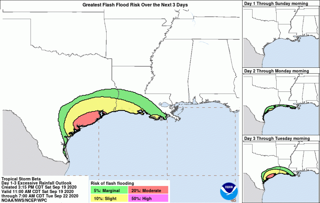
By Tuesday, when the ground is saturated, NOAA gives the Lake Houston Area a slight chance of flash flooding.

Six inches could fill smaller creeks; 7-8 inches could fill larger streams and bayous such as Buffalo. 

Addicks and Barker Reservoirs are currently empty.

Winds: 

Tropical storm force winds will be possible starting Sunday evening around Matagorda Bay with sustained 40mph winds likely spreading northward along the upper TX coast on Monday including Galveston Bay. Sustained winds of 55-65mph will spread up the TX coast Tuesday into Wednesday. Across Harris County wind will increase into the 25-35mph range on Monday and possibly 40-45mph range on Tuesday into Wednesday with higher gusts, especially near Galveston Bay.  

Note: Tropical storm force winds will begin to reach the coast on Monday…well ahead of any landfall of the center…due to the expanding wind field. Tropical storm force winds now extend 175 miles outward from the center of the storm.

Summary of Watches/Warnings In Effect

As of 4PM Saturday, 9/19/20:

A STORM SURGE WARNING IS IN EFFECT FOR

  • PORT ARANSAS TEXAS TO HIGH ISLAND TEXAS INCLUDING:
    • COPANO BAY
    • ARANSAS BAY
    • SAN ANTONIO BAY
    • MATAGORDA BAY
    • GALVESTON BAY

A STORM SURGE WATCH IS IN EFFECT FOR:

  • * BAFFIN BAY TEXAS TO PORT ARANSAS TEXAS INCLUDING BAFFIN BAY AND CORPUS CHRISTI BAY
  • * HIGH ISLAND TEXAS TO CAMERON LOUISIANA INCLUDING SABINE LAKE AND LAKE CALCASIEU

A HURRICANE WATCH IS IN EFFECT FOR:

* PORT ARANSAS TEXAS TO HIGH ISLAND TEXAS

A TROPICAL STORM WARNING IS IN EFFECT FOR:

  • PORT ARANSAS TEXAS TO INTRACOASTAL CITY LOUISIANA

A TROPICAL STORM WATCH IS IN EFFECT FOR:

  • SOUTH OF PORT ARANSAS TEXAS TO THE MOUTH OF THE RIO GRANDE
  • EAST OF INTRACOASTAL CITY LOUISIANA TO MORGAN CITY LOUISIANA

Protective Actions

  • Bookmark and monitor Harris County Flood Warning System throughout the storm. Familiarize yourself with the real-time inundation mapping feature.
  • Bookmark and monitor the National Hurricane Center for the most current updates on Beta.
  • Prepare now for a long period of coastal flooding and periods of heavy rainfall.
  • Voluntary evacuations have been recommended for:
    • Western end of Galveston Island, west of the seawall
    • Bolivar Peninsula
    • Low-lying areas of Chamber, Brazoria and Matagorda Counties (outside levee protection)
    • Low-lying areas of Seabrook.  

AlertHouston Recommends Taking These Steps Now

  • Ensure your family has 5-7 days of food, water, and necessary supplies.
    • This includes enough prescription medication for at least this duration, in case pharmacies and doctor’s offices are closed.
    • Consider the unique needs of small children, seniors, family members with access and functional needs, and pets.
  • Decide what you and your family will do if the storm impacts your area. Most City of Houston residents are not vulnerable to storm surge and do not need to evacuate before a hurricane or tropical storm. Vulnerable residents who require electricity may also consider evacuation in advance of a major storm. For a map of hurricane evacuation zones and mandatory evacuation areas, visit: houstonoem.org/hurricanes
  • Develop a family communication plan, so that you know who to check in with after a storm. Visit readyhoustontx.gov for more information on developing a plan.
  • Know how to turn off your utilities. This includes electricity, water, and gas. Only turn off gas if instructed by local officials or by CenterPoint Energy.

Posted by Bob Rehak on 9/19/2020 with data from the NHC, HCFCD, and City of Houston

1117 Days since Hurricane Harvey and 1 Year since Imelda

Flash Flood Watch: Training Bands of Heavy Storms Could Quickly Drop 4-6 Inches Or More

Jeff Lindner, Harris County Meteorologist just issued an alert concerning increasingly heavy rainfall potential for this evening. And the National Weather Service has issued a FLASH FLOOD WATCH for all counties in the Houston region.

Conditions Right for Heavy Rainfall

“Short range model trends are starting to paint a concerning picture for this evening,” said Lindner, “as a slow-moving, low-level boundary moves into the area and helps to focus a west-to-east oriented line of thunderstorms. Recent trends and high-resolution models suggest potential training bands of heavy rainfall this evening into the overnight hours.”

“Given parameters in place including deep tropical moisture, slowing storm motions, and a good feed of low-level flow off the Gulf, excessive rainfall rates of 2-4 inches per hour will be possible and this will lead to rapid street flooding.”

“If storms anchor or slow over an area for a few hours, the rainfall total could quickly reach 4-6 inches with higher isolated amounts,” said Lindner.

All Houston Region Currently in Danger Zone

Lindner feels all areas within the region may feel the effects. “Everywhere should be ready. As of Noon, I suspect the main focus area will be Waller, Austin, NW Harris, SW Montgomery Counties. But we will have to see how things develop this afternoon.”

For the moment the main concern is street flooding.

The front will lift back northward on Thursday and will likely trigger another round of showers and thunderstorms.

NWS Issues Flash Flood Watch

The National Weather Service in League City has issued a * Flash Flood Watch for portions of south central Texas and southeast Texas, including the following areas, in south central Texas, Coastal Jackson and Inland Jackson. In southeast Texas, Austin, Brazos, Burleson, Chambers, Coastal Brazoria, Coastal Galveston, Coastal Harris, Coastal Matagorda, Colorado, Fort Bend, Galveston Island and Bolivar Peninsula, Grimes, Houston, Inland Brazoria, Inland Galveston, Inland Harris, Inland Matagorda, Madison, Matagorda Islands, Montgomery, Northern Liberty, Polk, San Jacinto, Southern Liberty, Trinity, Walker, Waller, Washington and Wharton. *

From 7 PM CDT this evening through Wednesday morning

A line of strong thunderstorms will develop over southeast Texas this evening and slowly move eastward through Wednesday morning. A combination between the slow moving nature of the thunderstorms, back building/training of thunderstorms, and recent rainfall over the area has led to an increasing threat of flash flooding.

NWS predicts rainfall rates may reach one to three inches per hour or more at times.

The NWS also feels uncertainty remains in the timing and location of the line of strong thunderstorms.

On average, two to four inches of rain is expected through tomorrow morning with isolated areas of six to eight inches possible.

These storms with heavy rainfall may be capable of flooding roadways. Low water crossings may flood becoming impassable and dangerous. Small creeks and bayous may see minor rises.

PRECAUTIONARY/PREPAREDNESS ACTIONS

A Flash Flood Watch means that conditions may develop that lead to Flash Flooding. Flash Flooding is a very dangerous situation. You should monitor later forecasts and be prepared to take action should Flash Flood Warnings be issued.

Posted by Bob Rehak on 6/23/2020

1029 Days since Hurricane Harvey and 278 since Imelda