According to Harris County Precinct 3 Commissioner Tom Ramsey, PE, “Exciting plans are in motion for Edgewater Park in Kingwood!” Ramsey’s most recent newsletter says that starting in 2026, visitors can look forward to:
New trail connections
Improved access
Additional parking
A brand-new restroom facility
“And that’s just the beginning,” says Ramsey. “This is only Phase One of a three-phase project!” Future improvements will bring:
Even more trails
A playground
A public boat/canoe launch
Plans to redevelop the park were first announced in 2018 back when Kingwood was still in Precinct 4. Redistricting, permitting, budget, and wetlands issues delayed construction and forced the Precinct 3 Parks Department to rethink its plans.
Edgewater Park is located on the northeast corner of the San Jacinto West Fork and US59/Loop 494, just south of Hamblen Road.
Fourth Largest Urban Trail Network in North America
All of these upgrades are part of the Spring Creek Greenway connectivity plan. It will expand recreational opportunities across the region and create one of the largest urban trail networks in North America.
According to ChatGPT, the 40 miles of trails along Spring Creek and another 100+ miles in Kingwood would create the fourth largest urban trail network in North America. Only Calgary (600 miles), Philadelphia (400 miles) and Dallas (200 miles) have longer connected hike and bike trail networks.
Three Phases of Development Starting in Q4 2025
Edgewater Park will be developed in three phases:
Phase 1 – Regional Trail connecting under-crossing and Ross Road, parking lots and nature trail access, and a restroom. Ross Road is the westernmost road between Hamblen and the river.
Phase 2 – Additional Trail, Parking Lot, and Playground.
Phase 3 – Parking Lot and Public Boat Launch.
Heppen anticipates that Phase 1 will be bid in the 4th Quarter of this year with construction starting in the 1st Quarter of 2026.
Heppen provided this PDF showing the current plans.
Note that the plan contains four detention basins, two on each side of the utility corridor that bisects the park.
Heppen says that the ponds be shallow and have dry bottoms. The goal: let nature and the coastal grasses start to take over the bottoms to provide more of a natural feel.
Trails will wind around and over the basins and through the woods.
Heppen says that Phase 1 will form the backbone that enables future phases. It will create the final connection between the West Fork and Spring Creek Greenways. Once complete, residents will be able to use the Spring Creek Greenway from any point in Kingwood without going onto busy Hamblen Road.
Northern Parcel Will Remain Wetlands
The County owns some land north of Hamblen, too. However, at this time, Eric Heppen, PE, PMP, Precinct 3’s Director of Engineering, says the County has no plans for it at present.
Specifically, Heppen is referring to the area between Loop 494, the Laurel Springs RV Resort, Laurel Springs Lane, and Hamblen, which is dotted with cypress ponds.
Evidently, wetland considerations restrict development of that area.
Dog Park No Longer Part of Edgewater Plans
The county also originally had plans for a dog park in Edgewater. However, that has changed, too. Heppen says the county is now working with the City of Houston to find an alternate location in Kingwood.
Posted by Bob Rehak on 9/9/2025
2933 Days since Hurricane Harvey
https://i0.wp.com/reduceflooding.com/wp-content/uploads/2025/09/20250909-Edgewater-2026-Plans.jpg?fit=1100%2C719&ssl=17191100adminadmin2025-09-09 16:51:022025-09-09 19:00:51Development of Edgewater Park Restarting
1/16/2025 – Harris County Precinct 3 Commissioner Tom Ramsey, PE, and Distict E Houston City Council Member Fred Flickinger discussed the status of numerous flood projects at a meeting of the Kingwood Area Republican Women today at the Oakhurst Golf Club.
Ramsey addressing Kingwood Area Republican Women’s Club today.
Among the projects they covered were:
Taylor Gully Improvements/Woodridge Village Detention
Legal Changes Governing Pre-Release of Water from Lakes
Edgewater Park
Dredging
Medians
Flood Tunnels
Subsidence
Below are the highlights. They also discussed other issues such as median maintenance, vine control, crime, taxes, government waste, elections and more. But I will focus primarily on infrastructure issues related to flooding – especially Taylor Gully and Woodridge Village, because of pending approvals this month.
Taylor Gully/Woodridge Village
After Perry Homes clearcut approximately 270 acres in Montgomery County, hundreds of Kingwood homes flooded twice in 2019 along Taylor Gully. Taylor Gully runs through the northern part of Kingwood from Kingwood Park High School to White Oak Creek.
Harris County Flood Control District (HCDFC) began working on mitigation plans in 2021 and presented preliminary recommendations to the community in December, 2022.
The county had high hopes for funding from the Texas General Land Office (GLO) and U.S. Department of Housing and Urban Development (HUD), but those ran into a potential snag. Taylor Gully improvements fit within available HUD funding, but Woodridge Village (the former Perry Homes Property) did not. HCFCD hoped to build more stormwater detention basin capacity on Woodridge to help control Taylor Gully expenses downstream.
Regardless HCFCD pressed forward. They combined the two projects. And according to HCFCD, both now fit with available funding capacity (see “above the line” list on page 2) of the list being presented to Commissioners Court next week on 1/23/25.
The county purchased Woodridge Village in February 2021. Shortly thereafter, HCFCD began an excavation and removal (E&R) contract to get a “head start” on the basins. Indeed, the head start brought the total stormwater detention on the site almost to Atlas-14 standards.
However, HCFCD was forced to terminate the E&R contract before the basins could be completed. That was to comply with HUD requirements while HUD considered the grant application.
This is potentially great news for the people who live in Sherwood Trails, Elm Grove, Mills Branch and Woodstream.
Watch commissioner’s court closely next Thursday. The Kingwood area drainage study named this project as one of the two most important in Kingwood.
Kingwood Diversion Ditch and Upstream Detention
The Kingwood Diversion Ditch was the other of the two most important projects. The Diversion Ditch takes floodwaters out of Bens Branch, which runs diagonally through the center of Kingwood from St. Martha Catholic Church to River Grove Park.
Improving the Diversion Ditch would reduce flood risk for hundreds of homes and apartments, Kingwood High School, Town Center, and Kings Harbor. Both Bens Branch and the Diversion Ditch currently have a two-year level of service. That means they have a 50% chance of coming out of their banks in any given year.
Ramsey estimated today that the project could cost $60 million. However, he also indicated that U.S. Congressman Dan Crenshaw “got us enough money so we can do the final engineering.”
Eric Heppen, Precinct 3 engineer, later stated that once Commissioners Court approves the preliminary report, it will be made public.
Flickinger emphasized that he is talking with Montgomery County, trying to get them to retain more of their floodwaters. He raised concerns about a new 200,000 sq. ft. convention center planned for US59 at Valley Ranch. “That will generate a lot of runoff that could come down to us, unless we work together to find a way to hold that water up there.”
Houston City Council Member Fred Flickingerat same meeting.
Additional Floodgates for Lake Houston
Shortly after Harvey, many people pinned their flood-mitigation hopes on additional floodgates for the Lake Houston dam. The idea: to lower the lake faster when it becomes certain that a storm will flood the area. The existing gates have 1/15th the capacity of Lake Conroe’s. So Lake Houston must start releasing far earlier in advance of storms than Lake Conroe. And by the time Lake Houston is lowered, storms can veer away, wasting valuable water.
So Conroe tends to hold its water back until it is absolutely certain. At that point, it has no other choice than to release water at high rates that flood people downstream.
Being able to lower Lake Houston faster would let Lake Conroe release earlier and slower, smoothing out flood peaks downstream.
Ramsey estimated the cost of 11 new floodgates that could release 80,000 cubic feet per second at $150 million. He said the final engineering should be completed this year. He also said that bidding and construction could start in 2026.
Legal Changes Governing Pre-Release of Water
Flickinger addressed a related legal issue. State law limits the release of water from lakes; it must be only for defined beneficial uses and flood control is not one of them.
So, Flickinger is working with State Rep. Charles Cunningham to change that and increase the limit. “Bottom line,” he said, “is that we need to release more water sooner rather than holding it back until we’re adding to the crest of the flood.”
Flickinger is also working with the San Jacinto River Authority on these changes.
Edgewater Park
After Harvey, the County acquired land on the northeast corner of the West Fork and US59, which will turn into Edgewater Park. It will also connect the Houston Parks Board’s West Fork Greenway with the Spring Creek Nature Trail. Ramsey said the plans will be made public very soon. After the meeting, Precinct 3 engineer Eric Heppen confirmed the plans were 99% complete.
Ramsey said, “Soon, you’ll be able to go from Kingwood to Tomball and not cross a road.” That should be a tremendous draw for hikers and bikers and the entire area.
Dredging
Flickinger discussed two aspects of dredging not covered in last night’s post. First, he is seeking additional funding to continue the current program while the dredge is on the lake. Second, he feels opportunities exist to increase efficiency.
I asked what he meant by that. FEMA restrictions on the funds currently being used limit the dredging to “pre-Harvey” conditions. That means, Callan Marine, the contractor, must dredge to different depths to match the exact bottom profile that existed before Harvey. And that requires repositioning the dredge more than if you were just dredging to a uniform depth across wide areas.
The search for additional funding has led Flickinger to the City, the Coastal Water Authority (CWA) and former State Representative Dan Huberty. Huberty was appointed to the board of CWA last last year by Houston Mayor John Whitmire.
Medians
Several people from the audience questioned Flickinger about the medians along Kingwood Drive. He touted the success of his first Median Madness event in November 2024 and announced another on February 22, 2025. Mark your calendar now.
More than 50 volunteers participated in the last vine-cutting extravaganza. He hopes for many more volunteers this time.
Flood Tunnels
The county is getting ready to launch the next phase of its flood tunnel study. Ramsey emphasized that there isn’t enough room in Harris County to poke enough holes in the ground to solve all of our flooding problems. He sees tunnels that carry floodwater from strategic locations as essential parts of the solution.
Eric Heppen, Ramsey’s engineer said that by burying the 40 foot tunnels 80 feet underground, you can double the conveyance in some watersheds, sidestep environmental issues, and avoid having to condemn property.
But many issues have yet to be worked out. For instance, will tunnels be constructed to relieve 2-year, 5-year, 10-year, 25-year or 50-year flooding? More to follow when details become available.
Subsidence
Harris County estimates the area east of Lake Houston will grow by 18,000 homes in the next 10 years. But there currently are no plans to provide them with surface water. So, they will pump groundwater. That means subsidence. And subsidence means flooding, according to Ramsey. He pointed to Conroe as an example. The City’s groundwater pumping has caused subsidence as far south as Harris County.
Posted by Bob Rehak on 1/16/25
2697 Days since Hurricane Harvey
https://i0.wp.com/reduceflooding.com/wp-content/uploads/2022/12/20221206-Taylor-Gully.jpg?fit=1200%2C1200&ssl=112001200adminadmin2025-01-16 21:37:172025-01-17 14:29:08Ramsey, Flickinger Discuss Status of Flood Projects
There’s been a lot of water under the I-69 bridge since Harris County acquired the old privately owned Edgewater Park on the San Jacinto West Fork almost five years ago.
The county intended to start construction of a new bigger, better, public park with more amenities in 2019. The idea: turn floodway and floodplain land into an asset that would improve the community without exacerbating flooding.
Reportedly, however, pushback from Forest Cove residents over rerouting parts of Hamblen Road delayed the project. Then the City of Houston pushed back, too, on permitting for some buildings. Then came redistricting wars, budget battles, and a public-input session to determine what the community wants in Edgewater Park. Let’s first look at some pictures of the park and then review the new features.
Pictures Taken 5/23/23
I took the pictures below today. Edgewater Park will cover most of the land you see in the picture below between the river and that concrete patch in the upper middle (Laurel Springs RV Resort).
Looking NNE across San Jacinto West Fork toward Precinct 3 Edgewater Park.Looking NW. Hamblen Road cuts diagonally left to right through center of frame. Laurel Springs Lane cuts north (on right).Looking East downstream. West Fork Greenway will cut under bridge in the upper right.Looking east from approximately Hamblen and Laurel Springs Lane. West Fork Greenway will snake through this area on its way to 59 bridge.Looking SE. West Fork Greenway will ramp up to old truss bridge to take hikers and bikers across river.Note how far south the river has shifted. Those double trusses used to be centered over the river.Looking West. West Fork Greenway will connect with Spring Creek Greenway that snakes through the Forest on the West Side of US59. The Spring Creek Greenway will take people most of the way to the Woodlands with a couple small breaks.Winter photo showing oneof the beautiful cypress ponds north of Hamblen Road.Original (now outdated) plans for Edgewater Park at Hamblen Road and Loop 494
Elements of Plan B
Construction still hasn’t started and the County is rethinking its plans for the park. In the May 16 Commissioner Court meeting, commissioners approved Item 42 – funding to study Edgewater Park.
Eric Heppen, Precinct 3 Engineer says, “the study phase is just getting underway so there aren’t any bid specs at this time. But right now, we are looking at park components and materials that are more resilient and doing park improvements south of Hamblen Road only.”
Heppen adds, “In addition to a boat launch and parking lots there will be a small and large dog park, a playground, as well as both paved and unpaved trails. We are trying to build a park that will assist in serving the greater Kingwood area.”
“In addition we have been coordinating with he Houston Parks Board and connecting the Spring Creek Greenway into their trail network to enhance the overall trail system.”
“Our designer Quiddity has a landscape architect on its team. The architect has been tasked with adding plants that are native and will grow naturally to assist with natural mitigation efforts,” concluded Heppen.
Dog Park Fencing
The City of Houston requires dog parks to have fencing and Edgewater Park is in the City. Those who remember how logs collected in the railroad bridge supports next to the park during Harvey may remember how they contributed to catastrophic flooding.
Fencing can also collect debris swept downstream during floods. To prevent the fences from forming debris walls that make flooding worse, the City recommends a breakaway design. They attach the bottom of the chain-link fencing to steel poles with a steel ring. But they attach the top of the fencing to poles with plastic zip ties that break when pressure increases enough. That lets the fence flop down on the ground without being carried downstream.
You can see this ingenious system at the County’s Pundt Park along Spring Creek or in Buffalo Bayou Park downtown.
Types of Boats for Launch
Because dredging by the Army Corps stopped downstream of Edgewater Park, it will be difficult to launch larger boats with prop engines at Edgewater.
However, according to Heppen canoes and kayaks remain a possibility.
San Jacinto Greenway Link to Spring Creek Greenway
The Houston Parks Board is working with Harris County Precinct 3 to develop the West Fork Greenway and connect it to the Spring Creek Greenway. The map below shows the trail it will take from Woodland Hills Drive to the freeway.
Current extent. Trail will eventually continue west and cross over I-69/US59 via route shown in photos and first map above.
More on Edgewater as plans firm up. To see the master plan for Harris County Precinct 3 Parks, click here.
Posted by Bob Rehak on 5/23/2023
2093 Days since Hurricane Harvey
https://i0.wp.com/reduceflooding.com/wp-content/uploads/2023/05/20230523-DJI_0893.jpg?fit=1200%2C799&ssl=17991200adminadmin2023-05-23 15:55:282023-05-24 09:54:48Harris County Precinct 3 Rethinking Edgewater Park
Quick, somebody call Ripley. Against all odds, water appears to be flowing uphill at the Laurel Springs RV Resort.
Note the pond to the left of the detention pond near the tree line. A sharp drop off exists below the bank of the detention pond, toward Edgewater Park on the left. Now see closeup below.
The only apparent source for water in the circle is the pond on the left. But that’s below the water in the circle.
Is this an optical delusion? Or could something else be going on here? Could water actually be leaking through the dike?
Location of Buried Pipe
Back in January, contractors dug a trench through the dike and released the contents of the resort’s detention pond into Edgewater Park.
Silty stormwater being discharged into the wetlands of Harris County’s Edgewater Park below the RV resort. January 2022.
Later, a contractor told me his company removed the pipe. But I couldn’t find a single nearby resident who saw them do it. Subsequently, I’ve noticed water apparently leaking from the detention pond into the park after several rains…at this same spot! See below.
May 2022. Exact location shown in photos above.
So one possible explanation for this violation of the law of gravity could be that the pipe remains buried in the dike and water leaks through it. But I just can’t believe a contractor would lie to me!
If the pipe remains in the dike, that would seem to violate the owner’s construction permit. It says, in big red letters, “Stormwater Runoff Shall NOT Cross Property Lines.” I can’t believe the developer would violate permit terms either!
It’s hard being a small business owner these days. Do you violate Newton’s Law of Gravity or City law? Given a choice, it might be cheaper to go with Newton. So all things considered, I guess they figured out a way to get water flowing uphill. I’ve heard the owners are marketing geniuses.
I’m sure vacationers would drive their RVs from all across North America to see water flow uphill. Imagine the postcard sales!
Mysterious Black Spots Reappear
But that’s not the only possible tourist attraction. You’ve heard of people getting blood from a stone. At the Laurel Springs RV Resort, oil appears to simply ooze from the ground. Move over Beverly Hillbillies!
Looking North from over Edgewater Park. Note dark areas in red circle and see magnified image below.Photo taken 8/11/22.From a legal height, I shot straight down and photographed an oily sheen on the black spots.
This is the same location where I previously photographed contractors covering up black spots on several occasions. See one below.
Mysterious black spots in Laurel Springs RV Resort Detention Pond on March 10, 2022. Note bulldozer tracks.
Never ones to pass up a marketing opportunity, the RV resort owners reportedly hope to hire Max Baer, Jr., the last surviving member from the classic Beverly Hillbillies sitcom from the 1960s and 70s. Rumor has it, they want the 83-year-old Baer, who played Jethro, to be the first person through the gates at the grand opening. He would reportedly pass out samples of the oily substance so that RV owners across America can live the dream and tell their grandchildren how they struck oil while vacationing in Texas.
Concrete Galore
In another feat of marketing genius, the developer convinced the City of Houston permitting people that one third of the property would NOT be impervious cover, i.e., concrete.
The developer is not yet done with pouring concrete. But it appears as if it will cover a lot more than 2/3rds of the site.
Will one third really be pervious?
By the way, according Section 9.1.04.O of the City’s Infrastructure Design Manual, detention ponds count as 100% impervious cover regardless of whether they have wet or dry bottoms. So the pond doesn’t count toward the one-third – just those skinny slots between RV parking spaces. And does it look like they add up to seven acres!?
It looks like Harry Houdini would have a hard time squeezing between the narrower ones. Of course, Houdini died in the 1920s. So how will they divert attention from this one? The developer reportedly wants to hire David Blaine, reputed to be the world’s greatest living escape artist, to appear at the grand opening. Blaine will show anyone who complains about the tight parking spots how to squeeze into his/her RV.
I can’t wait for the star-studded grand opening when I get to see water flowing uphill, Jethro passing out oil, and City inspectors lining up for David Blaine’s autograph.
Posted by Bob Rehak on 8/11/2022
1808 Days since Hurricane Harvey
The thoughts expressed in this post represent opinions on matters of public concern and safety. They are protected by the First Amendment of the US Constitution and the Anti-SLAPP Statute of the Great State of Texas.
https://i0.wp.com/reduceflooding.com/wp-content/uploads/2022/08/20220811-DJI_0320-2-copy.jpg?fit=1200%2C799&ssl=17991200adminadmin2022-08-11 19:23:462022-08-11 23:06:37Water Flowing Uphill at Laurel Springs RV Resort
Here’s a short digest of nine flood-related items in the news this month.
Fifth Anniversary of Harvey
This month marks the fifth anniversary of Hurricane Harvey. It’s hard to pinpoint an exact day for Harvey. The system moved off of Africa on August 13, 2017. It became a tropical storm on the 17th; moved into the Gulf on the 22nd; became a Cat 4 hurricane; and made landfall at Port Aransas on the 25th. The outer bands reached Harris County on the 26th.
Harvey dumped heavy rain over Houston for four days. It started moving back offshore on the 29th and 30th. Ninety percent of the river forecast points in southeast Texas reached flood stage; forty-six percent reached new record levels. Harvey dumped more rain than any storm in the history of North America. For more information, see the Hurricane Harvey tab on the Reports Page.
West Fork San Jacinto During Harvey. Looking NE toward Kingwood from the Townsend Park N Ride.
New SJRA Director From Lake Conroe
Most flooding in the Lake Houston Area during Harvey happened after the SJRA started releasing 79,000 cubic feet per second (CFS) from Lake Conroe to save homes there. Many Lake-Houston-Area residents blamed the absence of downstream representation on the SJRA board for what they saw as disregard for their property.
After touring the extensive damage by helicopter, Governor Abbott appointed two Lake-Houston-Area residents (Kaaren Cambio and Mark Micheletti) to the seven-person board. Cambio later resigned to avoid a conflict of interest when she joined Congressman Dan Crenshaw’s staff. Last month, the Governor appointed a Lake Conroe resident to fill her vacancy, Stephanie Johnson. That now leaves Micheletti as the lone downstream representative.
Lone Star Groundwater Conservation District Elections
Sometimes it seems that the main requirements for membership on the LSGCD board are half a brain, a willingness to kiss Simon Sequiera’s ring and indifference to science. Sequiera owns Quadvest, the largest private groundwater pumping company in Montgomery County. And excessive groundwater pumping in MoCo has been linked to subsidence and flooding. But concerned citizens will have a chance to take back the LSGCD board from a slate of directors backed by Sequiera. The deadline for applying is August 22. This page on the LSGCD site is all about the election and how to file if you are interested.
Edgewater Park
Harris County Precinct 3 is trying to jumpstart the development of Edgewater Park at 59 and the San Jacinto West Fork. The county has stated it is hiring a new consultant to re-design the park and that construction could begin 1 to 2 years from now. Quiddity Engineering will get the nod. The project will provide a boat launch, an additional park for the Humble/Kingwood Area, and a connection to the Spring Creek Greenway hike and bike trail. Quiddity’s contract will cover design, engineering, and other pre-construction expenses. Quiddity is the new name for Jones and Carter.
Houston Planning & Development Department News
The Planning and Development Department has a new initiative called Livable Places. The objective: create more housing options for Houstonians. The four options they visualize all increase housing density and impervious cover. I wrote them asking, “Won’t that increase flooding?” In essence, they said, “But it may help other places stay green.” True. But that’s not going to help flooding in the City much. Wasn’t our Drainage Fee designed to provide an incentive to REDUCE impervious cover. Oh well. These are different times. Can we get our drainage fees back now?
Flood Tunnels
Harris County Flood Control District (HCFCD) released Phase 2 of its $30 billion flood tunnel study last month – along with a recommendation to study the recommendations in more detail. The current plan for Phase 3 is to spend the next 4-6 months:
Working with the Army Corps to explore possible federal involvement
Scoping the Phase 3 study
Beginning procurement.
HCFCD hopes to start Phase 3 in early 2023. Said Scott Elmer, P.E. CFM and Assistant Director of Operations for HCFCD, “We expect it to take approximately 3 years to complete.” For the complete Phase 2 study, click here.
GLO HARP Program Deadline
The Texas General Land Office (GLO) announced that applications for its Homeowner Assistance and Reimbursement Program (HARP) will close at 5 p.m. on Aug. 31, 2022. Those include applications for repairs/rebuilds from Tropical Storm Imelda in 2019. To be eligible, you must submit applications by the deadline … unless funding runs out first. So hurry.
The program includes repair or reconstruction of owner-occupied single-family homes and reimbursement up to $50,000 for certain out-of-pocket expenses incurred for reconstruction, rehabilitation, or mitigation. Repayment of SBA loans is also eligible for reimbursement.
The GLO has $71,604,000 to help residents of Harris, Chambers, Liberty, Jefferson, Montgomery, Orange, and San Jacinto counties. HARP is only available for a primary residences, not second homes. Interested homeowners should visit recovery.texas.gov/harp to apply online or download an application.
Harris County Attrition and Pay Reports
As reported in April, the loss of employees and managers in dozens of Harris County departments has created a brain drain that impacts delivery of county services. On Tuesday, 8/2/22, Commissioners considered two related reports. The first had to do with attrition. The second had to do with pay and benefits.
Commissioners did not discuss the first, but they did discuss the second at length. They also voted unanimously to have the Office of Management and Budget investigate pay disparities. Certain commissioners wanted to apply equity guidelines to low-paid employees and freeze pay for those making more. I didn’t hear the words “Pay for Performance” once during the discussion.
In the end, commissioners recommended having HR create a job architecture, pay structure, and new evaluations that would determine pay increases or freezes. More in future posts.
New Bond Package
Discussion of a new $1.2 billion bond package consumed the last 90 minutes of commissioners court this week. The County Administrator still cannot say where the money is actually needed. Commissioners Adrian Garcia and Rodney Ellis want to apply equity guidelines to this bond. And neither wants to say which projects they would spend the money on. Garcia even threatened in a previous meeting that Republican-leaning precincts would not get ANY of the money if their commissioners voted NO on the bond.
When Hidalgo suggested guidelines for distribution of the money, Garcia stomped out of the meeting. He later reluctantly agreed to a split that would give his precinct and Ellis’ $380 million each while Republican precincts would get only $220 million each.
During the debate, it came out that much of the money from the 2015 bond program still has not been spent. That raised the question, “Why do we need another bond?”
Bragging About Trickery on One Bond While Pitching Another
Also, Commissioner Rodney Ellis publicly bragged that he purposefully didn’t define “equity” in the 2018 flood bond. “It was side language,” he said. “It was not in the language that was on the ballot, but that was the side agreement we agreed to.”
Ellis later said, “Those poor neighborhoods are the ones who have gotten the short end of the process.” But the HCFCD July flood-bond update shows that Halls, Greens, White Oak, Brays and Hunting Bayou Watersheds have received $400 million out of the $1 billion spent to date from the flood bond. Twenty percent of the watersheds are getting 40% of the money. Short end?
I personally don’t plan to vote for another bond until I start seeing some benefit from the last two. Especially when there’s no guarantee how, where or on what the money will be spent. To me, this looks like a $1.2 billion dollar slush fund for Garcia and Ellis.
Posted by Bob Rehak on 8/6/22
1803 Days since Hurricane Harvey
The thoughts expressed in this post represent opinions on matters of public concern and safety. They are protected by the First Amendment of the US Constitution and the Anti-SLAPP Statute of the Great State of Texas.
https://i0.wp.com/reduceflooding.com/wp-content/uploads/2018/10/KVE-2017-Flood.jpg?fit=1500%2C968&ssl=19681500adminadmin2022-08-06 19:46:432023-06-11 18:30:31August Flood Digest: Brief Summaries of Nine Items in the News
But some problems, like the trees will be hard to correct. It could take decades for newly planted trees to reach the height of the old ones.
It’s hard to say exactly how many square feet of trees were lost beyond the property. The distance varies along the southern perimeter of the RV site. But another resident and I, using a tape measure and eyeballs, estimated the damage extended into the park for up to 50 feet south of a surveyor’s stake at the southern property line. If the estimates are close, that would mean the contractor harvested almost an acre of County trees.
Attempts to Clean Up Site
Since a two-day shutdown after the discovery of contractors flooding Edgewater Park with silty stormwater, the construction site has bustled with activity. Some employees have continued laying pipe, spreading fill, and grading. Meanwhile, others try to fix problems pointed out by inspectors.
Yesterday, contractors tried to retrieve dirt that eroded into or was placed in Edgewater Park. Last night, they erected silt fence along most of the southern perimeter. The muck-retrieval team was still working this morning. The contractors created a new entrance with fresh bullrock. And they also placed silt filters in front of storm-sewer grates along Laurel Springs Lane.
Photos Show Extent of Tree Loss
The orange stake below represents the southernmost stake of the developer’s RV park. It lines up roughly with the southerns edge of the detention pond’s bank. Edgewater Park is to the left.
Photo taken yesterday, 2/11/22 from Laurel Springs Lane looking west.County’s Edgewater Park is left of stake.
The position of the orange stake in this wider shot lines up a little bit north of the left end of this traffic island in Laurel Springs Lane.
Note position of orange stake relative to tip of traffic island. Photo taken 2/11/2022.Note where southern boundary would cross southern tip of traffic islandon right – same place as in photo.Note how far clearcut goes below southern tip of traffic island.Silt fence (placed last night) does not mark property boundary. It was placed where ground was dry enough to hold stakes, hence its irregular shape.Photo taken today, 2/12/22.Photo taken 2/12/22. On the western edge of the property, the new silt fence lines up with the southern edge of the pond bank and a little bit north of the still-standing trees above the fence. Note the same trees in the first photo relative to the orange stake.
Had the silt fence been installed from the start of construction – as the Stormwater Pollution Prevention Plan said it should have been – perhaps contractors would not have cut down the trees.
Pipe Apparently Still Buried
After digging a trench in the southern wall of the pond to discharge silty stormwater into Edgewater Park at the top of the frame, contractors then buried a pipe to create a permanent conduit. They still have not removed it to my knowledge. I visit this site every day and would likely have noticed people working on that. But all I saw was some dirt placed in front of the inlet and outlet. If still embedded, leakage through the pipe could explain the continued presence of silty water below the pipe in the trees at the top of the frame.
Red line marks approximate path of pipe buried by contractors.Photo taken 2/12/22.
Sometimes trying to take shortcuts can cost you more money in the long run than you save. Developers and contractors often get away with things because neighbors rarely read plans and watch to make sure they are followed. The assumption is that regulators inspect these sites daily. They don’t. We just don’t have enough of them.
Tomorrow…details of the developer’s Stormwater Pollution Prevention Plan filed with the TCEQ. You definitely don’t want to miss that one.
Posted by Bob Rehak on 2/12/2022
1628 Days since Hurricane Harvey
The thoughts expressed in this post represent opinions on matters of public concern and safety. They are protected by the First Amendment of the US Constitution and the Anti-SLAPP Statute of the Great State of Texas.
https://i0.wp.com/reduceflooding.com/wp-content/uploads/2022/02/20220210-RJR_9202.jpg?fit=1200%2C800&ssl=18001200adminadmin2022-02-12 19:22:452022-02-12 19:26:52RV Resort Contractor Cut Down Trees in County’s Edgewater Park
Lakewood Cove residents reported yesterday and today that contractors at the Laurel Springs RV Resort are pumping stormwater from their detention pond into Precinct 4’s Edgewater Park. The reports are true. And it’s a permit violation.
I also found contractors bringing in fill from the outside that I thought was going to be “cut” from the detention pond. All photos below were taken on 1/18/22.
Pumping From Pond onto Neighboring Property
The approved permit plans clearly state that “Stormwater runoff shall not cross property lines.”
Stamp on many pages of approved Laurel Springs RV Resort plans.
I guess at some point the water in the pond ceased being runoff. Now it’s just a nuisance. The plans said pond water would be pumped into the City storm sewers. Hmmmm.
Photographed from Laurel Springs Lane looking west.
Here’s an aerial photo looking toward Laurel Springs Lane.
Check out all the muck being washed into the woods. Those woods belong to Harris County Pct. 4. That’s part of new Edgewater Park.
Note the lack of silt fences in the two photos above. Plans clearly state that silt fences will be installed to keep silt from escaping the property. Double Hmmmm!
Bringing in Fill instead of Moving It From Within the Site
As I photographed the pumping, I noticed a parade of dump trucks bringing in fill, dumping it, and leaving as a bulldozer spread it out and another machine quickly compacted it.
Looking NW toward Lowes in top center. Note dump truck depositing fill – one of many that I watched.The area where they deposited fill just north of the pond corresponds to the plans. See below.
From text on the image above, I assumed that the job was to be a routine “cut and fill” operation. Maybe I shouldn’t have assumed.
Cut and Fill is an industry standard in floodplains. It means you move dirt from one part of the site to another. So, there is no additional fill brought into the floodplain. The fill area above appears to be in the .2% annual chance floodplain, according to the old FEMA map below. However, the developer did not mark the .2% chance floodplain on plans.
FEMA floodplain map. Aqua = 1% annual chance. Brown = .2% annual chance.It appears the northern part of the detention pond (not shown on this old satellite image) cuts between the aqua and brown areas.
For the record, Chapter 19 of Houston’s Code of Ordinances currently does not prohibit bringing fill into the .2% annual chance floodplain. See Section 19.34.
Posted by Bob Rehak on 1/18/2022
1603 Days since Hurricane Harvey
The thoughts expressed in this post represent opinions on matters of public concern and safety. They are protected by the First Amendment of the US Constitution and the Anti-SLAPP Statute of the Great State of Texas.
https://i0.wp.com/reduceflooding.com/wp-content/uploads/2022/01/20220118-DJI_0490.jpg?fit=1200%2C799&ssl=17991200adminadmin2022-01-18 20:33:432022-01-18 20:40:31RV Resort Pumping Stormwater Into Edgewater Park, Bringing in Fill
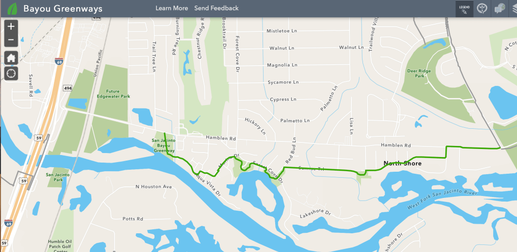
The Houston Parks Board’s newest leg of the San Jacinto Bayou Greenway is nearing completion. Construction started near River Grove Park in Kingwood and is working its way west toward Harris County Precinct 4’s new Edgewater Park at US59.
First Leg Now Concreted, Others Under Construction
The first leg of the concrete trail connects River Grove Park and the Kingwood Trail Network to Hamblen Road in Forest Cove. From there, the trail snakes through streets in the Northshore neighborhood, such as Northshore Drive and Sunrise Trail. It currently stops just north of the Forest Cove little league fields on Forest Cove Drive. However, the trail will continue west; that’s just the extent of current construction. At the ends of streets that don’t connect, the Parks Board is building connector trails for hikers and bikers.
The only portion of the San Jacinto Bayou Greenway completely concreted to date links Woodland Hills Drive and Hamblen. Other portions of the trail are partially concreted, and some are still being cleared. Construction fences are still up, even in the areas with concrete, as crews have not yet finished installing benches and planting grass.
Not Yet Quite Bike Ready
Net: Don’t take your bike through there yet. These pictures taken this afternoon show the current state of construction.
Looking west from the entrance to River Grove Park in Kingwood toward Hamblen Road in Forest Cove at the new San Jacinto Bayou Greenway trail.Closer view of same trail in same direction. Note the limited landscaping to date.Reverse angle looking east toward River Grove from the end of Hamblen Road in Forest Cove.Another leg of trail, not yet complete, connecting Northshore Drive and Sunrise Trail.Looking SW from Northshore.Where second leg of trail exits onto Sunrise Trail.Current end of construction activity at Forest Cove Drive just north of Little League Fields.
Trail is actively being cleared farther to the east, but it’s not yet passable. The cleared portion currently terminates at Marina Drive near the Forest Cove Pool, behind the townhomes destroyed by Harvey.
While th San Jacinto Bayou Greenway project will help to revitalize the area, some residents who survived the storm and rebuilt their homes lament the loss of seclusion. However, avid hikers and bikers will no doubt will love the trail which will connect to the Spring Creek Greenway and take people up to the Woodlands. It represents a vast expansion of connected trails in the area and will rival the largest urban trail networks in the country – if it won’t be the largest.
That will put Kingwood and Forest Cove back in the news again in an immensely positive way. It will also create a magnet that improves home values again and attracts younger couples with children trying take advantage of Humble ISD schools.
Harris County Commissioners Court unanimously approved two items on today’s agenda that could eventually benefit the Humble/Kingwood Area.
#60 Recommendation to execute a Partnership Agreement with TXDoT for preliminary engineering and environmental review for a railroad grade separation on Hamblen Road, from Loop 494 to Laurel Springs Lane.
#83 Authorization to negotiate an interlocal agreement for a partnership project with the SJRA, Humble, and five utility districts for a feasibility study and conceptual design on the Spring Creek Watershed Flood Control Reservoirs.
Consideration of the projects was originally scheduled for last Friday. But visits by President Biden and Governor Abbott delayed that part of the meeting until today.
More About the Projects
The first item will formally establish a partnership with TXDoT to study the feasibility of rerouting Hamblen Road north to meet up with a bridge over US59 at Sorters-McClellan Road. The project, is key to managing traffic in Harris County’s new 90-acre Precinct 4 Edgewater Park. The preliminary engineering study will also look at building a bridge over the Union Pacific Railroad tracks. The latter is important because UP has announced its intention to start running longer trains. If one derailed, it could theoretically block every exit to Kingwood.
Site of Precinct 4’s new Edgewater Park. Hamblen Road (center) could be re-routed north to connect with the bridge over 59 at Sorters-McClellan road (top center). The project could also create a railroad bridge over the Union Pacific tracks (right).
The second item will further explore the feasibility of one or more Flood Control Reservoirs upstream from the Lake Houston Area along Spring Creek. This could reduce the amount of inbound water during future floods. In that regard, it is worth noting that the amount of water coming down Spring Creek during Harvey almost exactly equaled the amount of the SJRA’s release from Lake Conroe. Thus, such a project could partially offset future Lake Conroe releases during floods.
Where Water Came From During Harvey. Source: SJRA.
Next Steps
Neither of these projects involves approval to begin construction. They simply will study the feasibility, locations, costs, and nature of construction. Commissioners would have to approve construction after studying the results of the studies. But first the engineering department and Flood Control District must solicit bidders to conduct the studies.
Posted by Bob Rehak on 3/1/2021
1280 Days since Hurricane Harvey
https://i0.wp.com/reduceflooding.com/wp-content/uploads/2018/04/Estimated-Peak-Flows-Hurricane-Harvey-Aug-25-29-e1555953215907.jpg?fit=1500%2C971&ssl=19711500adminadmin2021-03-01 17:55:382021-03-04 08:46:41Harris County Commissioners Approve Two Projects That Could Benefit Humble-Kingwood Area
Andy Li and Kelly Schafler reported in Community Impact that Harris County Precinct 4 should begin construction on Phase 1 of Edgewater Park by mid-2021. Phase 1 includes a 19-acre park, parking lot, boat launch, fish-cleaning station, restroom, concession building, and detention pond. Cost: $2.3 million. Location: Between Hamblen Road and the San Jacinto West Fork, immediately east of US59. See below.
Looking north at the future site of Edgewater Park from over the San Jacinto West Fork and the new UP Railroad Bridge. US59 on left.Looking South at Phase 1 of the future Edgewater Park. US59 on right. Hamblen Road in foreground. Humble in background.
Related Projects
Phase 2 will include the cypress ponds north of Hamblen and east of Phase 1. It also includes a potential reroute of Hamblen Road to unsnarl traffic and avoid
The park will provide a second boat launch in the Humble/Kingwood Area that will be open to the public. KSA’s boat launch at River Grove Park is open only to Kingwood residents with K-Stickers.
Two hike and bike trails are also planned as part of improvements. The first trail will connect the Spring Creek Greenway on the south side of the West Fork with the Townsen Park ‘n Ride. The second will connect Edgewater Park with River Grove Park and the Kingwood Trail Network. The Houston Parks Board also hopes to begin work on the second trail in early 2021.
The old Bevil Jarrell Memorial Bridge will connect trails on both sides of the river.
Reasons for Delays
“Getting approvals for both the right of way and the design to continue the Spring Creek Greenway under the existing railroad bridge took much longer than anticipated,” said Dennis Johnston, Precinct 4 Parks Director.
The Harris County Precinct 4 Parks website already shows the park under construction, but I haven’t seen activity there since the County put up a fence two years ago. Here’s what the plans looked like in 2018 when the County announced the project.
Tentative plans for a new Edgewater Park at Hamblen Road and Loop 494
Posted by Bob Rehak on December 27, 2020
2016 Days since Hurricane Harvey
https://i0.wp.com/reduceflooding.com/wp-content/uploads/2020/12/20201227-DJI_0012.jpg?fit=1200%2C900&ssl=19001200adminadmin2020-12-27 14:47:232020-12-27 14:49:18Construction of Long-Awaited Edgewater Park to Begin in 2021