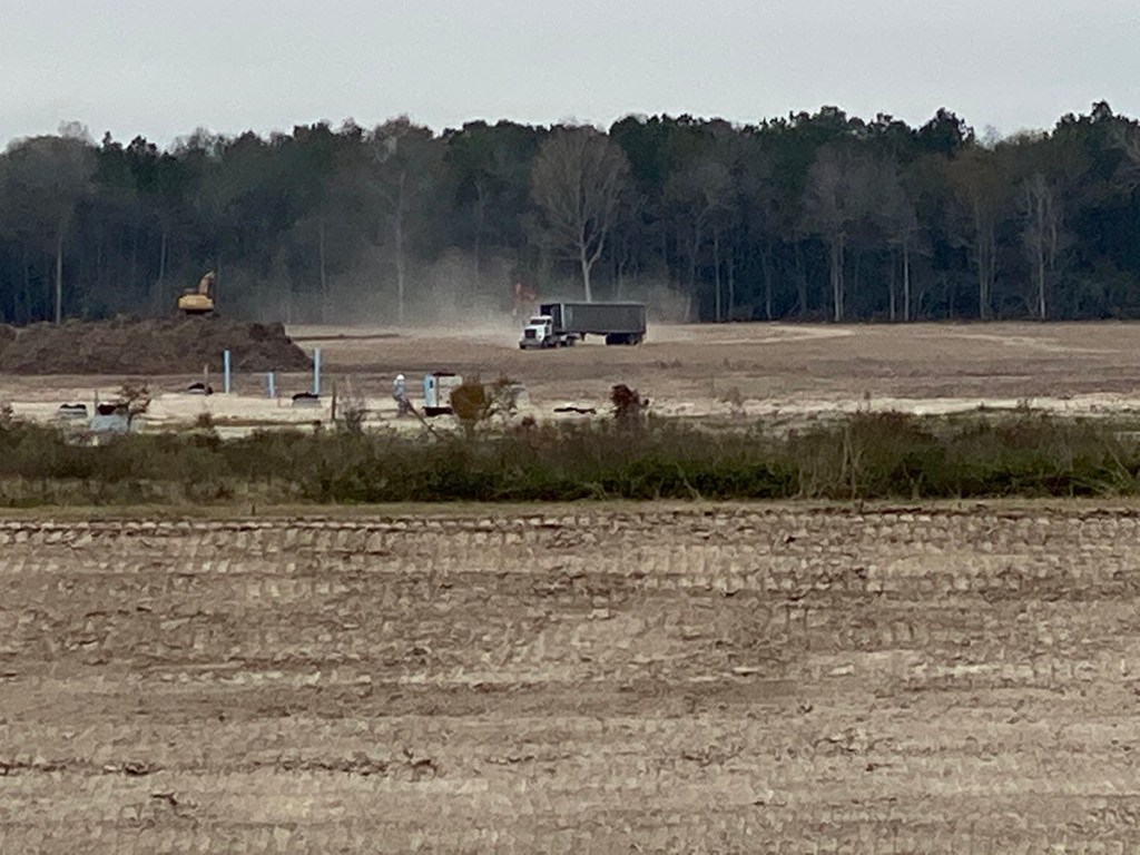
Instead of accelerating completion of detention ponds on Woodridge Village as Perry Homes promised, the company appears to have pulled all excavation equipment from the site. Contractors who were supposed to have been working on detention pond N-1 have gone…BEFORE they finished S2 and BEFORE they finished a berm sealing off the southern portion of the site at Fair Grove Drive.
Equipment Left Site Instead of Beginning On Next Pond
Perry Homes had promised in its letter to accelerate construction, but this will slow it down – if they ever return. The only work being done Friday? Removal of some dead tree piles on the northern portion of the site.
Jeff Miller took all the pictures and videos below on Friday and Saturday. He also monitored work on the site and provided this scouting report.
Looking south toward Taylor Gully and the Harris County Line along the eastern embankment of the S2 detention pond.The channel along the eastern portion of Taylor Gully is now lined with concrete. The spillway into the S2 detention pond has been widened and smoothed. The S2 detention pond is behind the camera position. Looking East.Looking west across S2 detention pond. The dirt that eroded into the pond has been scooped back up onto the banks and compacted.Still no grass on the banks, however, so it could all wash back in with the next big rain.Looking north. The grassy area in the background was supposed to have contained the N3 detention pond. However, contractors have simply excavated a channel from the northern section directly into Taylor Gully so now runoff can accumulate even more quickly.Contractors widened and concreted the Taylor Gully channel along the eastern side of Woodridge Village. But they left the most vulnerable part of the channel without concrete. At the end corner by the telephone poles, water comes from the left. But no concrete protects the area where the water makes a sharp 120 degree turn. Expect water to erode behind the concrete and peel it away in the next big rain.
Woodridge Village Section One Now a Virtual “Ghost Town”
This weekend, Woodridge Village Section One looked like a ghost town, not a bustling construction site with people working against a deadline.
Heavy construction equipment used to be parked by dumpster in the background. Now it’s nowhere on the property. Looking south. Another view of the same area that held construction equipment. It’s all gone and the berm sealing the site off from Fair Grove Drive is missing.
Still Removing Dead Trees/Mulch on Northern Section
On Friday, only smaller equipment turning tree piles into mulch remained.
Perry Homes Intentions Now a Mystery
As of Sunday morning 12/22/2019, no equipment actually working on construction could be seen on the site. The excavators and dump trucks parked at Fair Grove for months have been removed.
Perry Homes is NOT accelerating completion of detention ponds as it promised the City of Houston.
Instead, Perry Homes has thrown a curtain of silence around this job. It’s hard to know what their intentions are. At this point, Perry Homes’ lawyer J. Carey Gray has as much mud on his face as Elm Grove residents had in their homes.
The only thing we can say with certainty: Lowering flood risk for the people of Elm Grove does not seem high on Perry Homes’ priority list.
For Sale And For Lease Signs Serve as Christmas Yard Decorations
Meanwhile, a drive down Shady Maple or Village Springs, the two streets that border Taylor Gully, revealed residents’ attempts to salvage Christmas from the chaos of floodwaters. Dumpsters and debris still line the streets. Some people still live in trailers in their driveways. No apple cider around the hearth for them. They’ll be lucky to find space for a table top Christmas tree. For Sale and For Lease signs outnumber Christmas yard decorations ten to one.
On a street called Right Way in North Kingwood Forest, I found nine For Lease signs in a row. Sad reminders of Imelda and Perry Homes.Only three months ago, these homes were filled with families who flooded for the second time.
Kathy Perry Britton just added another credit to her resume, “The CEO Who Stole Christmas.”
Posted by Bob Rehak on 12/22/2019with reporting and images by Jeff Miller
845 Days since Hurricane Harvey and 94 since Imelda
The thoughts expressed in this post represent opinions on matters of public concern and safety. They are protected by the First Amendment of the US Constitution and the Anti-SLAPP Statute of the Great State of Texas.
https://i0.wp.com/reduceflooding.com/wp-content/uploads/2019/12/IMG_0679.jpg?fit=1200%2C900&ssl=19001200adminadmin2019-12-22 12:09:152019-12-22 12:58:38Perry Homes Pulls Excavation Equipment From Woodridge Village Before Finishing Detention Ponds
Note: This is the third in a five part series about What Went Wrong in Woodridge Village that may have contributed to flooding in Elm Grove and North Kingwood Forest.It focuses on Detention Ponds.
Section 7 of the Montgomery County Drainage Criteria Manual cautions, “The introduction of impervious cover and improved runoff conveyance serves in many cases to increase flood peaks quite dramatically over those for existing conditions.” And that’s exactly what happened in Elm Grove and North Kingwood Forest in May and September of this year. Two subdivisions that had never flooded before were inundated with several feet of water from Woodridge Village.
Perry Homes failed to observe numerous regulations in the Drainage Criteria Manual including provisions for:
Erosion control measures such as pond linings, revegetation, backslope swales
Maintenance roads
Increases in downstream flooding
Geotechnical reports for detention ponds
Drainage of detention ponds
Critically, they also failed to construct all the detention ponds they promised.
Less than a Quarter of Detention Ponds Built
When listing factors that contributed to the flooding, the absence of several promised detention ponds should rank near the top.
Before the September flood, contractors substantially completed a second detention pond (S2) that added another 16% of promised detention capacity.
Since then, no work has been done on additional excavation to protect against flooding.
While clearcutting ALL of the land, Perry Homes installed only PART of the detention.
According to LJA Engineering, Perry Homes was supposed to develop the project in two phases and clearcut only 30 acres in the northern section during Phase 1. However, something changed. Instead, Perry Homes clearcut the entire northern section. And they still haven’t excavated any of the three detention ponds there.
By May 2019, only S1 was substantially complete. By September, S2 was also substantially complete, but overwhelmed.
Had Perry Homes installed all the detention that it promised, the site should have detained a foot of rainfall. But it didn’t. When Imelda came along, it was like trying to pour 100 gallons of water into a 23 gallon jug. Water spilled out of the development into adjacent streets and homes.
Erosion Control Measures Missing for Detention Ponds
“The erosion potential for a detention basin is similar to that of an open channel. For this reason the same types of erosion protection are necessary, including the use of backslope swales and drainage systems (as outlined In SECTION 6), proper revegetation and pond surface lining where necessary. Proper protection must especially be provided at pipe outfalls into the facility, pond outlet structures and overflow spillways where excessive turbulence and velocities will cause erosion.” (See page page 123 of pdf, numbered 113 in doc.)
Revegetation?
Not much grass in S1 (right of the road) or the area that drains into it.All aerial photos below taken on 11/4/2019.Not much grass on the slopes of S2 either, although Perry Homes did make an ineffective attempt to hydromulch the south (right) border.
No Protection for Overflow Spillway
Perry Homes quality! This spillway from Taylor Gully (right) was supposed to have a grass lining, but still does not.Picture taken 11/4/2019.As of 11/21/19 work still had not started on the lining.Perry Homes has done virtually no work on this pond for three months.However, they did start lining the channel on the right today.
Backslope Interceptor Swales?
The northern edge of the S2 pond has no backslope interceptor swale. As a consequence, water from Taylor Gully at the top of this frame flows over the edge of the pond and erodes it. This may not be a sustainable solution. In the long run, the Gully could erode its way into the pond from the north (top of the frame).
Maintenance Road Missing at Critical Point
Section 7.2.8 talks about Maintenance of Detention Facilities. It states, “A 30-foot wide access and maintenance easement shall be provided around the entire detention pond.” The most critical place in the entire chain of detention ponds, the final outflow culvert into Taylor Gully, has no room for a maintenance road. That’s because when they installed the required backslope interceptor swale, the only place left for it was the maintenance road. That’s planning for you!
S2 has no maintenance easement or road at final outfall into Taylor Gully.The backslope interceptor swale takes up that space.
No Increase in Downstream Flood Levels Allowed
Section 7.3 talks about DETENTION DESIGN PROCEDURES. It clearly lays out the design goal when it says…
No increase in downstream flow rates or flood levels will be allowed.
Further down in this section, the regulations state: “The maximum 100-year water surface elevation in all detention facilities shall be a minimum of 1 foot below the minimum top of bank elevation of the basin.”
No Geotechnical Report for Groundwater Level at Pond Sites
Section 7.5 discusses GEOTECHNICAL INVESTIGATIONS. It says, “Before initiating final design of a detention pond, a detailed soils investigation by a geotechnical engineer should be undertaken.” Regulations state that the ground water investigation must be “at the proposed site.” Montgomery County has no record of such an investigation or report.
A company called Terracon prepared a Preliminary Geotechnical Report for Perry that addressed issues pertaining to utilities, road pavement and residential foundations. But it makes no mention of detention ponds.
The company took four widely spaced borings around the perimeter of the site that managed to miss all the detention pond locations. Significantly, they missed all the wetlands, too.
Page 17 of Terracon Report. Red lines added to improve visibility of locations.
MoCo Claims It Has No Further Geotechnical Reports
If Perry Homes did additional investigations into ground water on this site, Montgomery County says it doesn’t have them.
If no further investigations were conducted, this could be a fatal flaw affecting the economics of the entire development. Note the presence of standing water in the photo below.
S2 Pond (left), Taylor Gully (center), and area where N3 pond will go (right) all have standing water that will reduce their rated capacity.
The presence of standing water reduces the rated capacity of detention ponds and channels. Only the area above the standing water counts as capacity. Regulations say that these ponds should drain completely (see below).
Thus, S2 likely has lost a third of its designed capacity. N3, when eventually built, could fare worse. Note how close the water is to the surface in the small pond on the right.
If you can’t go deep to get your detention pond capacity, you have to go wide. And that will mean fewer homesites than the 896 they planned. This site might not even make economic sense for building homes.
Problems with Homes Built Over Wetlands
The presence of wetlands in the northern section, which the Terracon report never mentions, would also significantly reduce the site’s suitability for building homes.
This article describes the problems with homes built on wetlands. The title: “Caution: Building in a Wetland Can Be Hazardous to Your House.” A biologist for the US Fish and Wildlife service who investigated filled wetlands in Pennsylvania warned: “Build your house in a wetland, and you’ve got a hobby for the rest of your life. You will be fighting that water forever.” He discusses cracked foundations and also warns, “When wetlands are filled, the water that made them wet has to go somewhere. … the water likely is leaking into formerly dry homes of downstream property owners.”
I’m sure Perry Homes would divulge the presence of former wetlands to the future buyers of homes on this site. It’s the only ethical thing to do and Kathy Perry Britton, CEO, has standards to maintain.
Incomplete Drainage of Detention Ponds
Section 7.6 of the Drainage Criteria Manual addresses GENERAL REQUIREMENTS FOR DETENTION POND CONSTRUCTION. It states: “A pilot channel shall be provided in detention facilities to insure that proper and complete drainage of the storage facility will occur.” (Emphasis added.)
Complete drainage will likely never occur in S2 and N3 because of the high water table.
To excavate S2 to the required design depth, contractors had to continuously pump water out of it as they worked. It still retains water to this day.
Photo by Jeff Miller on June 2, three days after contractors started digging to the final depth.No surface linings were ever added to this portion of the pond per Section 7.2.7 of the MoCo Drainage Criteria Manual.Photo taken on June 3 shows contractors were pumping water out of pond as they continued excavating.
The new statistics would require 40% more capacity to ensure downstream safety.
Where Does Perry Homes Go from here?
After ignoring regulations, hundreds of homes flooded. And they will flood again. Owning this site is like hanging a millstone around one’s neck. It could drown the entire company in perpetual litigation and debt.
Future Posts in this series will look at:
Contradictions in Perry Homes’ Plans
The Dirt on Perry Homes’ Soil Test
The Floodplain that Wasn’t
Posted by Bob Rehak on 11/21/2019 with help from Jeff Miller
814 Days since Hurricane Harvey and 63 since Imelda
The thoughts expressed in this post represent opinions on matters of public concern and safety. They are protected by the First Amendment of the US Constitution and the Anti-SLAPP Statute of the Great State of Texas.
https://i0.wp.com/reduceflooding.com/wp-content/uploads/2019/11/RJR_4350-2.jpg?fit=1500%2C1089&ssl=110891500adminadmin2019-11-21 17:48:092019-11-21 18:26:13What Went Wrong, Part III: Perry Homes’ Woodridge Village Detention Pond Catastrophe
At this point, the world knew that flood maps would soon change radically. But the LJA report contains no mention of Harvey, USGS, or NOAA’s new Atlas 14 data. And in fact…
Less than one month after the LJA Engineering hydrology report, on September 27, NOAA issued new rainfall frequency values for Texas. Called Atlas 14, the NOAA analysis established significantly higher rainfall frequency values for this part of Texas.
New updated NOAA Atlas 14 data shows that a hundred-year rain for the Lake Houston area is now defined as 17.3 inches in 24 hours, up from 12.17 inches by the old standards.
NOAA redefined the amount of rainfall it takes to qualify as a 100-year or 1000-year event. They defined the new 100-year rain as 17.3 inches in 24-hours – a 42% increase. That means that to meet new 100-year standards, Perry would have had to increase its detention capacity by 42%. Instead of 271 acre feet, it would have needed 385.
Using Atlas 14 would have reduced the number of salable lots and the economic projections for the development to a substantial degree.
The one flood map in the 59-page LJA Engineering hydrology report shows flood plains magically stopping at the county line.
National Wetlands Inventory Map shows both sections of Woodridge Village contain wetlands.
Woodridge Plans Approved Even Before LJA Submitted Hydrology Report
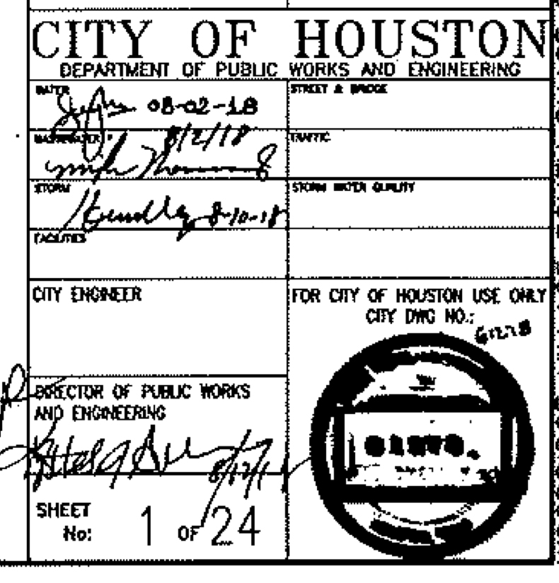
Now here’s where it gets even more interesting. City of Houston approved the detention plans on 8/12/18 – two weeks BEFORE the LJA hydrology report on 8/28/18 and only a month BEFORE NOAA released the new Atlas 14 data. Hmmmm! Think they were in a hurry to get these approved? (Note: The approval date for MoCo is unreadable).
Signature block for City of Houston from Woodridge Village detention plans.
Perry Homes played a game of beat the clock and was winning … until May 7, 2019.
Future Flood Risk Remains Even with Planned Detention Ponds
Until now, I have been posting about the lack of detention ponds. Closer analysis reveals that this is only part of the problem. Even if Perry builds the remainder of the detention ponds as planned, they will be insufficient to meet the new NOAA standards and will pose a flood risk to people downstream.
After contributing to two floods in Elm Grove and North Kingwood Forest, the engineers and owners of Woodridge Village surely must realize how dangerous trying to Beat the Clock was.
Forty-two percent of a 100-year flood as defined by the new Atlas-14 data will overflow the banks of the detention ponds and add to the load on Taylor Gully or go into the streets of Elm Grove and North Kingwood Forest.
Facing west. This panoramic drone image by Chris Betz takes in most of the Woodridge Village constructions site. Note the ponding water 3.5 days after a two-inch rain.
This image taken Friday night at Sunset shows how impervious the Woodridge soil is. Water is still ponding three and a half days after a two-inch rain (October 28, 2019).
795 Days after Hurricane Harvey and 45 after Imelda
The thoughts expressed in this post represent my opinions on matters of public policy and safety. They are protected by the First Amendment of the US Constitution and the Anti-SLAPP Statute of the great State of Texas.
https://i0.wp.com/reduceflooding.com/wp-content/uploads/2019/11/Aerial-Perry-Sml.jpg?fit=3553%2C851&ssl=18513553adminadmin2019-11-01 23:33:312019-11-03 20:13:20Woodridge Village Detention Calculations Off by More Than 40% According to New Standard
A week after J. Carey Gray, a lawyer representing Perry Homes’ subsidiaries and contractors, promised the Mayor of Houston that his clients would move as quickly as possible to complete Woodridge detention ponds, there still has been no excavation activity at the job site. And in fact, according to Jeff Miller, an Elm Grove resident who visited the site today, much of the material and equipment that had been on site are now gone.
Lack of Detention Implicated in Two Floods
Twice in four months, Elm Grove and North Kingwood Forest flooded severely when water from Perry Homes’ troubled Woodridge Village development overflowed into the streets of those communities immediately south and east of Woodridge.
Before the May flood, Perry had clearcut virtually the entire 268 acres, but installed only 7% of the detention.
Before the September flood, they had substantially completed only one more pond, bringing the total to 23% of the planned detention.
Percentage capacity of the five planned detention ponds on the Woodridge Village construction site as measured in acre feet. To date, only S1 and S2 are substantially complete.
So it’s not too surprising that the completed detention ponds overflowed in heavy rains.
It was like trying to store 100 gallons of water in a 23 gallon container.
Excavation Work on Detention Ponds Stopped for Two Months
As the pictures below show, there’s one piece of excavation equipment on the northern portion of the site and it hasn’t moved for about a month.
Looking west at northwestern section of Woodridge Village from helicopter more than a month ago, on 9/21/2019, two days after Imelda. Note the yellow excavator with its bucket resting on the ground in the middle of the frame toward the tree line on the right.Note the same excavator in the same place in the same position at the left of the frame. Photo taken 10/16/2019 from opposite direction, looking east.The foreground is where detention pond N1 should be. But the pond has not yet been started.According to the LJA Engineering report, it should have been excavated as part of the first phase of development.
Eight days later, you can see the same equipment still in the same place. However, it appears that two other pieces are now parked with it.
Photo taken by Jeff Miller on 10/22/2019 shows excavator in same photo it was photographed in on 9/21/2019, a month earlier.
Only Modest Repair Work on Ponds Since August
Resident Jeff Miller reported that an excavator removed some eroded sediment out of one completed pond (S1) after Imelda. Below is the photo he took on 10/6/2019. However, this was repair work, not newexcavation work.
According to the LJA Engineering Drainage Impact Analysis, Table 3, Phase 1 of this development was to have FOUR detention ponds installed: N-1 and N-2 (regraded pilot channel) on the north, S-1 and S-2 on the South.
However, no new detention capacity exists on the northern section which has the steepest slope and the largest surface area. It was to provide 77% of the total detention.
N-1 and N-2 should provide 62% of the detention capacity. However, N-1 doesn’t exist. N-2 is not fully excavated. And N-3, which will provide another 15% is only a distant dream.
Hundreds of Families Remain at Risk
The lack of progress on detention places hundreds of families at risk as we slog our way through another 5 weeks of hurricane season. The season ends on November 30. But flood-weary residents also remain wary of non-tropical storms, such as Tax Day, Memorial Day, and May 7th this year. In the moist, Gulf-coast region, heavy storms can strike any time of year.
Now, there’s an iron-clad contract if I ever saw one! However, as of October 22, 2019, no residents that I consulted around the site had seen any workers recently. Mr. J. Carey Gray, Attorney at Law, dated his letter October 17th.
According to resident Nancy Vera who lives immediately south of the construction site, there has been no recent construction activity anywhere on the site that she or her family can see.
Gretchen Smith who can see the site from her front yard in Porter has seen no workers.
Jeff Miller visits the site almost daily to check progress or non-progress of work. He had not seen any workers lately either. Moreover, he said that much of the materials and heavy equipment that had been stored on site appear to be gone.
Maybe Mr. Gray needs to consult with Larry, the Cable Guy.
Posted by Bob Rehak on 10/23/2019, with help from Jeff Miller, Nancy Vera, and Gretchen Dunlap-Smith
785 Days since Hurricane Harvey and 34 since Imelda
All thoughts in this post represent my opinions on matters of public policy and safety. They are protected by the First Amendment of the US Constitution and the Anti-SLAPP Statute of the Great State of Texas.
https://i0.wp.com/reduceflooding.com/wp-content/uploads/2019/10/Excavator-Highlighted.jpg?fit=1500%2C1000&ssl=110001500adminadmin2019-10-23 00:11:302019-10-23 00:12:40One Week After Town Hall, Still No New Work on Woodridge Village Detention Ponds
Stormwater detention basins store potentially damaging floodwaters temporarily until channels can safely carry water away. Here’s how they work.
Lack of Detention Ponds Contributes to Flooding
The lack of functioning detention ponds in the new Woodridge Village development contributed to the flooding of at least 196 homes across the southern county line on May 7th earlier this year. Since publishing a series of stories about flooding in Elm Grove, dozens of Montgomery County residents have contacted me about similar complaints.
Woodridge Village had only one of five detention ponds fully functioning when this shot was taken after the May 7th flood. Lack of retention for this clear cut area contributed to damaging 196 homes in Elm Grove and North Kingwood Forest, plus an unknown number of additional homes in Porter.Drone Footage courtesy of Jim Zura, ZuraProductions.com
All the stories follow a similar pattern. “We never flooded. Then a new development came in and we did.” Residents complain that frequently the new developments alter drainage without adding enough detention to mitigate flooding.
As population growth extends northward in Montgomery County, this will become an oft repeated story. It will affect everyone in Montgomery County, not just those in the southern part and Harris County…unless the loophole is closed.
Case Studies Dramatize Value of Detention Ponds
Doubt the value of detention ponds? Consider these three case studies by FEMA. Each deals with severe rain events and explains how a pond helped reduce or eliminate flooding altogether – for homes that previously flood repetitively. Together, they make a pretty powerful case for closing the loophole.
The second discusses a municipal pond in Pine Forest, a small town in Orange County, TX, north of Beaumont. After construction of the pond, “The community of roughly 500 residents and those living downstream from the ponds reported none of the flooding they had seen in the past.”
Victoria Project Protected Homes and Tax Base During Harvey
Closer to Houston, the third talks about a project in Victoria, TX. When Harvey hit the city of 68,000 in August 2017, 440 homes avoided flood damage. The City had completed the Lone Tree Creek Channel Improvement and Detention Facility Project there more than a decade earlier.
In 2005, the city recognized that its rapid residential growth created an overwhelmed drainage basin. Leaders began the planning stages of the Lone Tree Creek Project. “This project forced the creek to store water in the detention pond and not in the residential area,” said John Johnson, floodplain manager for Victoria.
Bottom line: “We are not moving the problem and recreating it elsewhere,” said Johnson.
“The quality of life is improved, and property resale is up as a result of this project,” said Johnson. “The tax base remained intact and property ownership stabilized in neighborhoods surrounding the Lone Tree Creek Channel. The quality of life is improved, and property resale is up as a result of this project.”
If you, or anyone you know, intend to speak at the Montgomery County Commissioners Court meeting on the 27th, use these real-world examples to reinforce the message to close the loophole.
Help Close the Loophole
Closing the loophole is a no brainer, or at least, it should be. However, if the court on August 27 is packed by developers and not citizens, expect the status quo – more flooding.
Posted by Bob Rehak on August 10, 2019 with drone footage from Jim Zura
711 Days since Hurricane Harvey
Thoughts expressed in this post represent my opinions on matters of public policy and safety. They are protected by the First Amendment of the U.S. Constitution and the Anti-SLAPP statute of the great state of Texas.
https://i0.wp.com/reduceflooding.com/wp-content/uploads/2019/05/Muck.jpg?fit=1500%2C828&ssl=18281500adminadmin2019-08-10 19:27:042019-08-10 19:31:31FEMA Case Studies Dramatize Value of Detention Ponds in Flood Reduction
One month into the 2019 hurricane season, only about 23 percent of the Woodridge Village Detention Ponds have been substantially excavated and have outflow control devices installed. At the time of the May 7th Elm Grove flood, that percentage was only 9 percent. So in a little less than 2 months, Rebel Contractors has more than doubled the percentage completed. However, as we head toward the peak of hurricane season, approximately three quarters of the detention capacity remains unexcavated, dysfunctional, or both.
Contractors also have yet to finish grading, planting, and cementing portions of the ponds that they have excavated.
Only 2 of 5 Detention Ponds Substantially Excavated
The first phase of the 268-acre Woodridge Village shows a total of 4 detention ponds. But Rebel Contractors has excavated only two on the southern end so far: S1 and S2.
Together they provide a total of 49 acre-feet of storage. Pond N1 has not yet been excavated and Pond N2 does not yet have an outflow control device that will retain the water upstream from Elm Grove.
Detention for Phase 1 of Woodridge Village
In Phase 1, Pond N2, has no additional excavation. Existing excavation was done by Montgomery County starting in 2006. The county removed approximately 3-4 feet of dirt in a 20 acre area. Ultimately, N2 will be the largest pond in the development with 154.7 acre feet of detention. Note: the figures quoted below differ slightly from those I quoted earlier because LJA Engineers presents conflicting data in its Drainage Impact Analysis for Montgomery County.See pages 7 and 54.
UltimateDetention for Woodridge Villagefrom Page 7 of the document titled Report Addendum-2027-1002.N2 currently covers about 10 acres to a depth of 6-8 feet. However, it will be enlarged and deepened so that it holds 154.7 acre feet.That’s more than half of all the detention on the property.
Ultimately, the 5 ponds will have a total of 271 acre feet of storage. An acre foot covers one acre to a depth of one foot. So the five ponds will hold a little more than one foot of rainfall per acre of development.
Woodridge Village Detention by Pond in Ultimate Phase
That means, 12 inches of water should be able to fall on the entire development without flooding any adjoining properties. But with only 23% of detention functional (S2 – green, and S1 – blue), that 12 inches of detention is effectively reduced to 3 inches right now.
How Much is Functional and Where?
The bullet points and pie chart below summarize the total storage and current status of each pond as of July 1, 2019. The figures for acre-feet are taken from the map above representing the ultimate phase of development.
N1 = 13.2 acre feet (not started)
N2 = 154.7 acre feet (started by Montgomery County circa 2002, but is not fully excavated, nor is there any outflow control device installed to detain water upstream of Elm Grove)
N3 = 42 acre feet (does not appear to be started)
S1 = 18.6 acre feet (mostly functioning, but not fully finished)
S2 = 42.5 acre feet (mostly functioning, but not fully finished)
Total detention when complete = 271 acre feet
Total detention not functional as of July 1, 2019 = 77%
Video of Woodridge Village Detention Pond S2 shot from north of Village Springs in Elm Grove at end of June. Courtesy of Jeff Miller.This shot, also by Jeff Miller, gives you a sense of the scale of the S2 detention pond.Remember, as large as it looks, it’s only designed to hold 16% of the runoff above it.Taylor Gulley below the concrete box culvert that controls the outflow from S2 is becoming badly silted.Those openings are each supposed to be 10′ x 6′. They look far less than that right nowbecause of the sediment.
N2 Will Contain More than Half of All Detention
Google Earth image showing the triangular shaped N2 detention area in March of 2011.This land was partially excavated by Montgomery County circa 2006-2012. The developer plans to widen and deepen it, but has not done so yet.Google Earth image showing same area in February of 2019.According to MCAD-tx.org, Montgomery County still owns the triangular area that will become Detention Pond N2.This is what N2 looked like at the end of May. It had not changedsince the May 7th flood.N2 from the reverse angle looking south on 7/1/19. Still no appreciable change.
N1 – Still No Excavation
This is where the N1 detention pond should be on the north section near the Webb Street entrance.No excavation in sight.
N3 – Still No Excavation Visible
Likewise, no excavation is visible near where the N3 pond should be.
In Phase 1, Figure Four, a subsidiary of PSWA and Perry Homes, will develop 30 acres in the northern section and 58 acres in southern section. Ponds N1, S1 and S2 are to be built during this phase.
The hydrologist notes that a portion of N2 is already in place (although there is nothing there yet to detain the water upstream from Elm Grove). She also notes that:
N2 will be widened during the Ultimate phase
A pilot channel within N2 and the E-W channel immediately downstream will be graded during Phase 1 to provide flow-line continuity with other proposed structures.
A concrete lined channel on the eastern side of the subdivision will be extended 150′ between the E-W junction and a 36″ plastic pipe.
Much work remains before their tables and charts on water flow can be used.
Remember, per their own report, the larger portion of Woodridge Village is in the north. It comprises two thirds of the development and the ground there slopes 10 times greater than the southern portion. (1 degree vs. 0.1 degrees).
The Woods are Gone, But We’re Not Out of the Woods Yet
As Elm Grove resident Jeff Miller said, “It sure seems to me that once they clear cut the north, that the potential for flooding rose exponentially.”
Let’s see!
More clear-cut area.
No functional detention.
Sloping toward Elm Grove.
And only one fourth of the total detention installed on the southern section.
I would agree.
As we approach the second anniversary of Harvey in 7 weeks, everybody on the periphery of this development is on edge…no pun intended.
Montgomery County needs development rules that protect neighbors from such development practices.
Posted by Bob Rehak on 7/1/19with help from Jeff Miller
671 Days since Hurricane Harvey
All thoughts expressed in this post are matters of opinion and safety involving public policy. They are protected by the First Amendment of the US Constitution and the Anti-SLAPP Statute of the Great State of Texas.
https://i0.wp.com/reduceflooding.com/wp-content/uploads/2019/07/Phase2-Detention.jpg?fit=1500%2C1191&ssl=111911500adminadmin2019-07-01 23:14:372019-07-02 07:29:30Only 23% of Woodridge Village Detention Ponds Now Functional