Tag Archive for: detention ponds

Two New MoCo Developments Will Total Almost 3,400 Acres, Have No Detention Ponds

Two new developments in Montgomery County, Audubon in Magnolia and Country Colony in Porter, will have no detention ponds. The two developments total almost 3,400 acres. During heavy rainfalls, they will dump their floodwater directly into local streams.

How Do They Get Away With That?

Sixteen months ago, on the second anniversary of Harvey, Montgomery County commissioners voted to leave open a loophole that lets developers avoid detention pond requirements. They said they would revisit the issue after the San Jacinto River Basin Study was completed. Even though partners shared study results with the public last August, MoCo commissioners have still not revisited the loophole called a “flood routing study,” also known as hydrograph timing.

The commissioners expressed concern in their 2019 meeting about placing economic hardships on developers. Residents complained about the economic hardships caused by flooding. The developers won.

Theory and Problems with Flood Routing Studies

The idea behind flood routing is simple. If you can show you can get your floodwater to the river faster than a flood’s peak arrives, theoretically, you’re not adding to the peak. Therefore, theoretically, you’re not making flooding worse.

However, engineers and hydrologists point out several flaws with this “beat the peak” theory.

  • Flood-routing studies don’t consider the cumulative effects of other developments.
  • They are almost always based on outdated hydrologic models.
  • They assume “ideal” storm conditions.

“If you start with a brand new hydrologic model,” said one county engineer, “the modeling a developer does could theoretically be accurate. But his/her runoff changes the model. That runoff rarely gets incorporated into the model that the next developer uses.” 

And, of course, if everybody rushes floodwater to a river during a flood, that’s the exact opposite of what you want. Holding water back in detention and retention ponds is the best way to reduce flooding.

The two new developments in MoCo exploit this routing-study loophole to avoid the cost of building detention ponds.
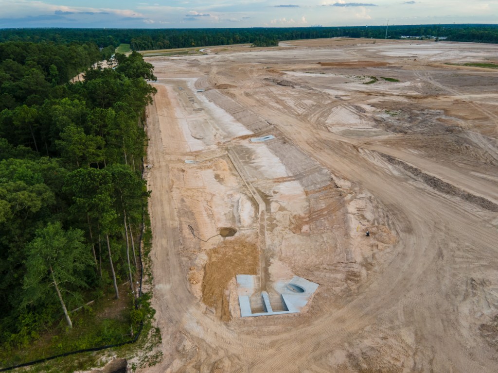
Audubon in Magnolia

The first, called Audubon Magnolia will contain 5,000 homes at buildout. It occupies 3,300 acres that drain into Mill Creek, Spring Creek and then the West Fork San Jacinto.

Here is the entire 186-page Drainage Impact Analysis for section one. It also shows project plans and location.

From Audubon’s drainage impact analysis. Note school being placed at edge of floodplain…before new floodplain maps are redrawn based on Atlas-14.

Section 3.1 of the Impact Analysis includes a description of the flood routing study and concludes, “Therefore, the increased flows are able to exit into Mill Creek before the flow from the bulk of the upper drainage basin arrives at the mouth of the stream.”

Correspondence with Montgomery County officials at the front of the document shows their concerns: use of pre-Atlas 14 data; impact on wetlands; building in floodplain; roughness co-efficients used to model speed of water over various terrains; and impact on water surface elevations.

Clearly, the floodplain administrator had major concerns about use of pre-Atlas 14 rainfall data. However, the developer was grandfathered based on the date of the original permit application.

Montgomery County’s new Atlas 14 standards increased the total for a 24-hour, hundred-year rain by 4 inches. The Flood Plain administrator encouraged the developer to model the higher rainfall totals and build to higher elevations. Why? To ensure the likelihood of compliance for those homes in the future.

These documents, dated 2019, are the latest available from Montgomery County. The county engineer’s office indicated that no detention ponds are being planned by the developer or demanded by the County.

Country Colony in Porter

The second development, Country Colony, lies just north of the Harris County/Montgomery County line at the end of West Lake Houston Parkway. Country Colony occupies approximately 80 acres immediately west of the Triple PG sand mine.

Note county line at southern edge of development. Also note how some of the lots are actually in the floodplain of White Oak Creek.
Country Colony. Taken December 7, 2020, looking east toward Triple PG Sand Mine in background.

No detention ponds here either! A big heads up to the people downstream in Walden Woods, Woodstream Forest and beyond.

Posted by Bob Rehak on 12/12/2020

1201 Days since Hurricane Harvey

The thoughts expressed in this post represent opinions on matters of public concern and safety. They are protected by the First Amendment of the US Constitution and the Anti-SLAPP Statute of the Great State of Texas.

Interim Guidelines for Atlas-14 Implementation Until New Flood Maps Released

While reviewing the MAAPnext website today, I came across this 1-page PDF that outlines major changes to Harris County’s Policy Criteria & Procedure Manual (PCPM). It describes changes – based on new Atlas-14 Rainfall Statistics – that engineers and developers must follow when designing and constructing flood-control features as part of any development within Harris County.

Atlas 14 Updates Rainfall Frequency Estimates Developed in 1960s

Developers must now design detention and storm sewers around rainfall rates that increase 16-32% compared to the old standards for Harris County.

Data included in Atlas 14:

  • Replaces rainfall-depth information used since the 1960s
  • Provides estimates of the depth of rainfall for average recurrence intervals of 1 year through 1,000 years, and durations from 5 minutes to 60 days.

NOAA collected this data in Texas through December 2017, which includes rainfall from Hurricane Harvey.

New Atlas-14 Rainfall Frequency Estimates for the Lake Houston Area

Floodplain, Detention & Fill Restrictions

The amended policy manual adopts the increased precipitation rates. It also specifies more rigorous criteria for detention basins and fill within the floodplain.

Amendments anticipate that the future Atlas-14 1% (100-year) floodplain will equal the current 0.2% (500-year) floodplain.

Harris County Flood Control District

Therefore, these amendments are considered to be interim and will be reevaluated once new floodplains have been produced as part of HCFCD’s Modeling Assessment and Awareness Project (MAAPnext) in late 2021. You can find more information on MAAPnext at www.maapnext.org.

Zero Net Fill

The old guidelines prohibited developers from adding fill only within the 100-year floodplain. Now they’re prohibited from adding fill within the 500-year floodplain, too. The policy is called “zero net fill.” It means developers cannot bring fill into the floodplains. They can, however, excavate fill from one part of their property and use it to build up another part of their property.

Under new guidelines, developers cannot bring fill into either the 100-year or 500-year floodplains.

For a 20-acre development, the average volume of stormwater within detention basins will increase by about 20%, or about 32,500 additional gallons per acre.

Effort to Harmonize Floodplain Regs with Neighbors’

Harris County works with surrounding counties and municipalities to upgrade and harmonize their floodplain regs. However, the effort has not yet yielded much fruit.

Surrounding counties, such as Liberty and Montgomery, have not yet mirrored these restrictions. In fact, those counties still use their comparative lack of regulation as a competitive tool to attract new development. That, of course, makes it doubly difficult for residents of Harris County. They must not only contend with their own runoff, they must contend with their neighbors’.

Posted by Bob Rehak on 11/30/2020

1189 Days since Hurricane Harvey

Construction of New Kingwood Middle School Starts With Temporary Detention Pond

Humble ISD recently started construction of the new Kingwood Middle School. The gorgeous, new upgrade to Kingwood’s oldest middle school should open in the 2022 academic year. The new building will occupy the northern half of the site where the athletic fields used to be. After contractors finish the new building, they will then demolish the old one and rebuild the athletic fields on the southern half of the site. See below.

Temporary detention pond in foreground will service the site during construction. The new school will be built behind the old one (left).

Temporary Detention Along Cedar Knolls

Thankfully, one of the first elements of the site is a substantial detention pond on the site of an old parking lot. This pond will be temporary.

Close up of the temporary detention pond on the site of the old parking lot.

The ISD will replace it with a permanent one between Pine Terrace and the new running track. Contractors will then fill the old pond in and pave it over to replace the parking lot.

Construction Sequencing

The following diagrams show how the school district intends to sequence the construction. Contractors are currently in Phase 1B. They have built the temporary detention pond, and cleared/graded the site of the new school. After the new school is built (1C), they will demo the old one and build a second detention pond facing Pine Terrace in Step 2A. The final step (2B): rebuilding the athletic fields, filling in the temporary detention pond and repaving the parking lot.

When complete, the main entry of the new middle school should look like this.

New Kingwood Middle School: a new showcase for Kingwood. Quite a step up from the fortress-like, windowless schools built back in the Seventies and Eighties.

For More Information

You can learn more about the project by visiting the Humble ISD 2018 Bond Fund website.

This video of the October 22, 2020 Humble ISD board meeting contains a presentation on the features of the new school. It promises to be a showcase for all of Kingwood. The part of the video about the new school starts around three minutes in. They discuss construction phasing starting at 13:42.

Nervous Neighbors Can Sleep Easier

A few blocks north and west of here, a cluster of homes not far from North Woodland Hills Elementary flooded during Imelda last year. While that situation was likely due to inadequate storm sewer design, I’m sure KMS neighbors will sleep easier knowing that detention ponds are a major part of the new KMS project from the start. They can certainly take some of the pressure off overloaded storm sewers.

Posted by Bob Rehak on 11/23/2020 with help from Chris Bloch

1182 Days since Hurricane Havey

How Much Rain Would It Take To Flood Elm Grove Again?

As Tropical Storm Beta bears down on the Houston Area, many people in the Elm Grove/North Kingwood Forest area worry that they might flood again. How likely is that, given the current predictions of 6-10 inches? After all, on May 7 last year, Elm Grove flooded on what was officially a six inch rain according to the nearest gage at West Lake Houston Parkway and the West Fork.

Additional Detention in Woodridge Village Now…

First of all, understand that upstream conditions have changed. On May 7th, only about 11% of the planned detention pond capacity had been constructed. And only 23% was constructed by Imelda. Today, 100% is in place.

…But Detention Based on Pre-Atlas 14 Rainfall Rates

Even though that’s far more than Woodridge Village had during the May or September floods, the detention calculations by LJA Engineering were based on pre-Atlas 14 rainfall rates. A 100-year rainfall then was about 40% less than the official 100-year rainfall now.

So, the questions is, “How much rain would Beta have to dump on Woodridge Village before it overwhelmed the detention ponds that exist today?”

Figures Used by LJA

The chart below shows the rainfalls that the ponds were designed to hold without flooding. The bench mark its the 24-hour, hundred year rain.

These figures come from the hydrology report submitted by LJA to Montgomery County. A table buried on page 32 of the PDF shows that they based their analysis on a pre-Atlas 14, 100-year storm that dropped 12.17 inches of rain in 24 hours.

From Page 2.1 of LJA Hydrology Report Addendum, 8/28/2018 (page 32 of pdf.)

The ponds should also hold any of the shorter-duration rainfalls in the last column above.

Assumptions Underlying the Answer

To answer the question – How much would it take to flood Elm Grove again? – we need to make several assumptions:

With those caveats in mind, it would take 12+ inches of rain in 24 hours to exceed the capacity of the detention ponds currently on Woodridge Village. After that, water would start to overflow.

Short, High-Intensity Downpours Can Cause Different Type of Flooding

However, consider the other durations in the chart above. Seven inches in three hours or nine inches in six hours could also exceed the capacity.

Actually, as you get into these short-duration, high-intensity rainfalls, you introduce the risk of flooding from a second source: overwhelming the capacity of storm drains.

Storm Drains Designed for 2″ Per Hour

The storm drains in Kingwood are designed to convey about two inches of rain per hour. When you exceed that, water begins to back up in the streets. Exceed it enough, and water could actually enter homes – without sheet flow from Woodridge Village.

NHC Rainfall Prediction Spans 5 Days

The six-to-ten inch prediction issued by the National Hurricane Center for Beta spans five days. That’s good news. If ten inches were evenly spread out over five days, the streets, drains and ditches could easily handle two inches per day.

But those short, high intensity rainfalls – when you get two inches in five or ten minutes – represent a real danger. There’s just nowhere for the water to when it comes down that quickly.

Perhaps the Biggest Danger

Even if we got the predicted 6-10 inches all in one day, that’s still, at most, about 80% of the old 100-year rain which the detention was designed for.

I suspect the biggest danger from Beta may be those short, high-intensity cloud bursts or training feeder bands that dump a couple inches in five or ten minutes.

So keep your eye on the rain gage. Sign up for alerts at the Harris County Flood Warning System. Also, keep your eye on the forecasts; uncertainty still exists with Beta, its track and rainfall potential.

Posted by Bob Rehak on 9/19/2020

1117 Days after Hurricane Harvey and 1 year after Imelda

Harris County Commissioners to Consider Purchase of Woodridge Village Again in Tuesday Meeting

Harris County published the agenda for next Tuesday’s Commissioners Court meeting. Once again, the purchase of Woodridge Village is on the agenda. The Perry Homes property contributed to flooding in Elm Grove Village twice last year, after the developer clear cut the land but did not yet install detention. Now, even with detention installed, the amount will likely be insufficient to forestall future floods because the engineers calculated the volume needed based on pre-Atlas 14 rainfall estimates. The new Atlas-14 estimates are about 40% higher than the old ones.

Since the 2019 floods, both the City and anxious Elm Grove residents have been urging the county to purchase the property and turn it into a regional floodwater detention facility to help protect homes in the Taylor Gully Watershed.

Commissioners first considered the purchase in April. When they could not reach agreement then, the issue resurfaced in several other meetings, but Precinct One Commissioner Rodney Ellis kept heaping new conditions on the deal. First he wanted the City of Houston to pay for half the purchase price. Then, half the construction cost of building additional detention. The the City also had to adopt Atlas 14. And the City had to upgrade multiple development regulations to become consistent with County regs. And the City couldn’t just promise to do those things in an interlocal agreement. Future tense. They had to actually do them. Present tense.


Agenda Item 1T Under County Engineer

Item 1T Reads:

Recommendation that the court find a public necessity exists for the Flood Control District to purchase Tracts G503-06-00-01-001.0 and G503-06-00-01-002.0 in Montgomery County from Figure Four Partners, Ltd., in the amount of $14,019,316 plus closing costs for the Woodridge Village stormwater detention basin, and that the Real Property Division Manager or Assistant Division Manager be authorized to sign any agreements or closing documents associated with this transaction.


Documentation attached to the agenda item mentions the previous conditions put on the sale, but also focuses on “public necessity.” Declaring a property a public necessity is necessary before the county could purchase it. Even if commissioners approve this agenda item, they would need to revisit the issue to ensure the City has complied with all conditions the commissioners previously imposed on the sale.

The letter from the County Engineer to commissioners also proposes an inter-local agreement, which Commissioner Ellis previously objected to.

Status of Perry Detention Ponds

Excavation of all five detention ponds on the Perry site is complete, although some finish word remains on N3. Contractors finished S1 and S2 earlier this year. Since then, they have also virtually completed N1, N2 and N3. All pictures below were taken within the last two weeks.

N1 in the northwest corner of Woodridge.
N2 in the middle part of the western perimeter.
N3 along the eastern border of the site.

Together, these three ponds comprise 77% of the total acre/feet of detention on the site.

The newly excavated increase of capacity will help protect Elm Grove residents in rainfalls up to 12.17 inches. But complying with the new Atlas-14 regulations would require protection from a 17.3 inch rain in 24 hours. That’s about 40% more. Hence the need to purchase the property before it is developed into homesites.

TD 14 could test LJA’s design of the ponds when the tropical system makes landfall next Tuesday.

Latest Update on Tropics

At 7 p.m. EDT, the National Hurricane Center issued updates on the two tropical systems that threaten the northern Gulf. Both could affect the Texas/Louisiana area on Tuesday. That should be around the exact time commissioners are scheduled to meet virtually. I’m assuming the meeting could be postponed if the storm turns into an emergency.

I’ve heard rainfall estimates ranging from 3 to 18 inches for the storm(s). Here’s what the storms are currently doing according to the National Hurricane Center.

Tropical Depression 14 is currently dumping three to six inches of rain in the eastern portions of the Mexican states of Quintana Roo and Yucatan, with isolated maximum totals of 10 inches.

Tropical Storm Laura is also expected to dump three to six inches of rain in the Dominican Republic, Haiti and Cuba, with isolated totals up to eight inches.

NHC predicts both storms will intensify into hurricanes in coming days.

Only this morning, the cone was centered on Mississippi and Alabama.
Tropical-storm-force winds currently extend outward up to 115 miles (185 km) from the center, but the storm is projected to intensify into a hurricane before making landfall.

If these two storms merge, things could get interesting. Compared to the last two days, the cone of uncertainty for TS Laura keeps shifting to the west. And its wind field now includes the Houston Area.

Posted by Bob Rehak on 8/21/2020

1088 Days since Hurricane Harvey

The thoughts expressed in this post represent opinions on matters of public concern and safety. They are protected by the First Amendment of the US Constitution and the Anti-SLAPP Statute of the Great State of Texas.

Humble ISD Constructing Transportation Facility Next to Woodridge Village

In 2018, voters approved an Humble ISD school bond that included a new northern transportation center. The 11.7-acre center is currently under construction at 24755 Ford Road, directly across the street from the new construction entrance for Woodridge Village. Concerned residents wonder whether the extra acreage could make flooding worse.

Source: Montgomery County Appraisal District

Humble ISD says the target opening date for the new transportation center is 2021. Having an additional transportation center will save an estimated $2 million in operating costs, they say, due to shorter routes and improved response times.

Transportation Centers Use Lots of Concrete

This video shows what the old bus center looks like. Lots of concrete! It is a giant parking lot. But the District does have two small detention ponds for the 29-acre site (see below).

Old Humble ISD transportation center at Will Clayton and Wilson. Note detention ponds and bottom and right of photo. Source: Google Earth.

Note that the old site is in Harris County and the new one is just across the county line in Montgomery County which has more lax regulations.

Residents Question Whether Site Will Add to Flooding

There is some good news, however. According to USGS, there were no wetlands on this site. Nor does FloodFactor.com for FEMA show that the Transportation Center is any danger of flooding, unlike its neighbor, Woodridge Village, to the west.

New Transportation Center property is by red pin. Woodridge Village is to left, across Ford Road. Source: FloodFactor.com.

Some residents have questioned whether the new transportation center will add to their flood woes. That’s unclear. It depends on whether the District puts detention ponds on the site.

Construction Photos As of 6/16/2020

Recent construction photos below suggest that they will, but the District has not yet responded to a request for a drainage analysis and site plan. See the status of construction below. All photos taken on 6/16/2020.

The cleared space on the right is the northeastern section of Woodridge Village. The one in the upper left by the cell tower is the new Humble ISD transportation center. Looking southeast toward Lake Houston in background.
Tighter shot of new transportation center shows clearing is complete. Area between cell tower and top corner looks like it could become a detention pond.
Even closer shot shows them laying stormwater sewers toward back corner.
Close shot of drain pipe. From the size, it looks as though they expect a lot of runoff.
It also looks like they are pouring a concrete bed for the pipe.

New Ag Barn Just Blocks Away

The District’s new ag barn will also be in the same vicinity, about two blocks south – right where Ford Road turns into Mills Branch Road. During the last bond election, shortly after Harvey, the District decided to relocate the ag barn from Deer Ridge Park for the safety of students and animals.

The District has just started clearing land for that project.

The high rate of development in this area makes it imperative that everyone adheres to drainage best practices to prevent flooding. As more information about these and other projects becomes available, I will post it.

Posted by Bob Rehak on 7/2/2020

1038 Days since Hurricane Harvey and 286 since Imelda

Perry Detention Ponds Pass First Modest Test, But Eroded Badly

The official rain gage at West Lake Houston Parkway and the West Fork San Jacinto recorded 2.32 inches of rain between 7 and 9 a.m. this morning. That was officially a 1-year rain. (See Atlas-14 chart below.) As rains go, it was not a severe test; it was more like a pop quiz.

After the rain subsided, Taylor Gully in Elm Grove was less than half full.

The good news: Taylor Gully was well within its banks and no one in Elm Grove or North Kingwood Forest flooded. The bad news: Perry’s detention ponds experienced severe erosion, enough to warrant repairs and perhaps delay the schedule.

The even worse news: Harris County’s meteorologist, Jeff Lindner predicts another one to two inches of rain tonight with isolated totals of three to four.

West Lake Houston Pkwy. Gage Showed 2.32 Inches In 2 Hours

24 hour rain totals for WLHP gage showed bulk fell in 2 hours.

2.32 inches in two hours qualifies as a one-year rain according to the new Atlas-14 rainfall precipitation frequency estimates. Even if you considered the entire 3.12 inches in 24 hours, it would still only be a one year rain.

Atlas 14 Precipitation Frequency Table for the Kingwood Area.

Aerial Images Show How Perry Detention Ponds Performed

These aerial images taken shortly after noon today when the rain stopped show that:

  • The detention ponds are starting to do their work and hold back water.
  • That kept the level in Taylor Gully manageable
  • The overflow spillway between S2 and the concrete-lined channel was apparently not needed.

However, the images also show that:

  • Portions of the detention pond walls severely eroded and appear to have collapsed in places.
  • The water in the N1 pond overcame temporary dirt barricades sending water and silt down to N2.
  • The newly excavated N2 was entirely covered with water for the first time. It also received a significant amount of erosion.
  • N3 merges with Taylor Gully to form one large detention pond that holds water all the way from the northern end of the pond to the county line.
  • Rain has halted construction for the last two days and could delay it into next week.
Expanded, giant N2 detention pond was covered entirely with water for first time. Looking West toward western border of Woodridge Village.
However, erosion re-deposited large amounts of soil within the pond. Looking North along Western Border of Woodridge Village.
Rainwater entering the site from Joseph street in Porter (center left) shows by comparison how much silt the Perry water held. Looking north along western border of Woodridge Village.
Still looking north, but farther up western border, you can see silt slumping into ditch.
Looking SE toward Elm Grove and North Kingwood Forest from the NW corner of site. Water coming in N1 pond from left exited right, down the western border. Water washed out a temporary dirt barrier that appeared designed to hold water in the pond.
Looking east. Note erosion from former utility corridor on left that has turned into a new drainage ditch along northern edge of property.
Looking at western wall of N3 which runs along eastern border of Woodridge Village.
Another portion of the western wall of N3 shows severe erosion.
Standing water from rest of property is slowly making its way into detention ponds.
Looking South along eastern border toward Taylor Gully. At present, N3 (bottom left) simply merges with the concrete channel by S2 (top right). It appears to have nothing to control the outflow.
Looking north along eastern border. Silt fences prove inadequate at stopping erosion. In fact, most of site has no silt fences.

More Rain Likely Tonight

Jeff Lindner, Harris County meteorologist, says that today’s wet pattern should remain in place through the weekend, contrary to earlier predictions that saw rain chances ending by Friday.

Storms currently in the Gulf near Corpus Christi are tracking toward Houston late tonight and Friday morning. They will probably not be as severe as this morning’s storms. With that said…the air mass remains tropical over the region and excessive rainfall rates of 2-3 inches per hour will be possible, warns Lindner.

As of 6 p.m. Thursday, the National Weather Service decided NOT to issue another flash flood watch for tonight, but stay alert to see if a more significant threat may develop.

Expect rainfall amounts of generally 1-2 inches tonight with isolated totals of 3-4 inches.

To Get Up-to-the-Minute Forecasts and Stream Alerts

You can always find up to the minute weather forecasts at this National Weather Service page.

To check on rising rivers and major streams, visit the Harris County Flood Warning System, and click on channels and channel status simultaneously. To see further upstream, click on All Gages. That will show you the status of gages operated by the SJRA in Montgomery County.

Posted by Bob Rehak on 6/25/2020

1031 Days since Hurricane Harvey and 280 since Imelda

The thoughts expressed in this post represent opinions on matters of public concern and safety. They are protected by the First Amendment of the US Constitution and the Anti-SLAPP Statute of the Great State of Texas.

Perry Contractors Now Focusing on Finish Work for Detention Ponds

Perry Homes’ current contractors have excavated 3X more detention pond volume in ten weeks than the previous contractors did in virtually two years. During this past week, they finished excavating three ponds on the northern section of Woodridge Village. Together, they comprise 77% of the total detention volume for the whole site.

Excavation Done, but Finish Work Remains

That doesn’t mean they’re totally done with the ponds. Recent aerial photos show that they still have much finish work to do. That includes:

  • Shaping the sides
  • Creating backslope swales
  • Installing pipes to funnel water from the swales into the ponds and channels
  • Ensuring water can flow out of Adams Oaks in Porter on the west side of the subdivision into Taylor Gully as it previously did
  • Creating concrete “pilot channels” in the center of the ponds and larger channels
  • Planting grass along the sides of the slopes to reduce erosion
  • Installing outflow control in several places to hold back floodwaters
  • Building maintenance roads around the ponds

Elm Grove resident Jeff Miller, who monitors the progress of construction daily, says crews are already hard at work on many of those tasks.

Ponds NOT Expanded Beyond Initial Plans

Miller has compared the width and depth of ponds to the initial plans and verified that the ponds are being built to original specifications. Since the ponds were designed to meet pre-Atlas 14 rainfall requirements, that means the site will still hold 30-40% less runoff than needed to meet current regulations.

Still, surrounding residents in Porter, North Kingwood Forest and Elm Grove who flooded twice last year will find three large ponds on the northern section a welcome addition. They provide some measure of extra protection. Residents will have four times more upstream detention volume than they had during Imelda.

Racing Against Risk

With the peak of hurricane season now less than two months away, Perry Homes is in a race against risk. The company may regret the six months of virtual inactivity between the completion of pond S2 and the start of work on ponds N1, N2, and N3 in early April.

The faster pace of current construction puts pressure on Harris County and the City of Houston to complete an offer if an offer will be made. Elm Grove residents lobbied the City and County to purchase the property and build a regional flood detention facility. They center would also help protect downstream residents on the East Fork and Lake Houston.

However, at a Kingwood Town Hall Meeting in February, Mayor Pro Tem Dave Martin announced that the City would not participate in a deal. He said it was the County’s responsibility.

In April, the County announced that it would consider purchasing the land if the City contributed land in lieu of cash to cover half the purchase price.

Then in May, the County increased its demands. The County now wants the City to contribute land in lieu of cash to cover half the purchase AND construction costs for creating additional detention.

County and City Clamp Down on Communications

Since then, the County has clamped down on communications regarding this subject. Rumors suggest that all parties are still trying to make a deal happen. But the County has denied all FOIA requests and referred them to the Texas Attorney General for a ruling on their denials. That often happens when negotiations are in progress, according to a knowledgeable source.

What Happens Next?

At the contractor’s current rate of progress, it’s entirely possible that contractors will complete all work on detention ponds in July.

The City and County blew through a May 15 deadline that Perry put on the deal. But a “For Sale” sign at the Woodland Hills entrance remains on the property.

With approximately $14 million dollars invested in the property, with hurricane season here, with lawsuits pending, and knowing that the amount of detention is insufficient to hold a 100-year rain, Kathy Perry must be sweating bombshells.

Ms. Perry may be hoping for a City/County offer, but she can’t be counting on one. If she were, she could have sold the dirt coming out of those detention ponds. Instead, however, she’s building up land elsewhere on the site to keep her options open and develop the site if a deal falls through.

That dirt will have to be moved again at taxpayer expense if the county builds additional detention ponds.

Pictures of Site as of 6/19/2020

Here’s what the site looked like as of 6/19/2020.

Looking NW from over Taylor Gully toward Pond N2, the largest on the property.
The connecting channel between N1 at the top of the frame and N2 along the western edge of the property has been excavated. Note the pilot channel that contractors have started in the distance.
At Mace Street in Porter, contractors created a concrete face for the twin culverts on the upstream side, but not yet on the downstream side. Note the earthen dam holding water back while contractors complete the pilot channel running off the bottom of the frame.
Above Mace Street, contractors are still putting in pipes between the channel and backslope swales.
The Webb street entrance to the site has been removed to connect N1 (out of frame on the top) with N2 (out of frame on the lower left).
Looking SE at N1.
Looking South at N3, which runs down the eastern edge of the property.
More pipes are being put in to channel water from backslope swales to the pond so water won’t erode the face of the pond. Not the rills already cut in the dirt.
Looking SE. The southern half of N3 where it connects with Taylor Gully in the upper right.
N3’s connection to Taylor Gully is now wide open. It’s not clear how this connection will be completed to release the water at a slow controlled rate.
The two culverts under the bridge over Taylor Gully should slow the water from N2 (upper right) and N1 (out of frame) down.

Need for Grass if Deal Not Reached Quickly

Note how the grass on the southern side of the gully has all died. That raises a question. If Perry, the City and County do not complete a purchase agreement soon, will Perry plant grass on the northern section to slow runoff. Right now, it’s all hard-packed dirt.

Most of northern section is hard packed dirt which increases runoff rate.

Planting grass over an area this large would be a big investment and might get in the way of construction if Perry decides to develop the land. But it will reduce flood and legal risks.

Posted by Bob Rehak on 6/20/2020

726 Days after Hurricane Harvey and 275 after Imelda

“The Developers Are Coming! The Developers Are Coming!”

Actually, the developers are already here and licking their chops over the extension of the Grand Parkway (SH 99).

My riff on Paul Revere’s famous line is not meant so much as a statement of impending doom as about the need for caution.

Certainly, there are many honorable developers who try to build high-quality communities for people without adversely affecting downstream residents. I don’t wish to malign a whole profession. Nor do I want to fail to acknowledge the many wonderful communities they have built in this area.

But there are also some developers who put profit before people. They try to cut corners wherever they can and hope that nobody will notice. Especially regarding flood control. It’s expensive and easy because most people don’t understand it.

Grand Parkway Coming Soon To Wetlands Near You

The construction of State Highway 99, aka the Grand Parkway, has opened up vast new areas on the outskirts of Houston to developers. Many of those areas consist of wetlands and forests.

TxDoT is currently prepping land for Section H of the Grand Parkway almost all the way to FM 1960 on the east from US59.
From USGS. Wetlands near the path of Grand Parkway extension. Compare with maps above and below.

Visible Difference in Development Density Where SH99 Completed

The map below shows permit applications in the north Houston area. Compare the density of projects around sections of the Grand Parkway that have already been completed (left) with the areas on the east where the concrete has not yet reached.

This map shows permit applications in the northeast Houston area, both within the City and its ETJ (extra territorial jurisdiction. The Colony Ridge development featured below is outside the ETJ (green area) in the upper right of the map above.

Developers have even more projects underway outside the City’s ETJ (not shown on the map above).

How Development Can Affect Flooding

Kingwood residents have seen how one developer can contribute to flooding hundreds of homes. Last year, Perry Homes clearcut 268 acres north of Elm Grove before installing detention ponds. Hundreds of Elm Grove homes then flooded on May 7 and again on September 19, during Tropical Storm Imelda.

Below are recent photos of a massive 10,000 acre development in Liberty County near Plum Grove. It is about to become a 15,000 development now, thanks in part to Grand Parkway access. And yet it has only one small traditional detention pond.

Detention ponds slow down the rate of runoff to compensate for the loss of trees, wetlands and ground cover that have been replaced by streets and rooftops.

Their goal: to prevent downstream flooding.

Colony Ridge Accounts for All Growth in Liberty County In Last Decade

Colony Ridge can account for all the growth in Liberty County in the last decade. Below are some photos of Colony Ridge and its expansion near Plum Grove. The approach of SH99 will make it more accessible and therefore more attractive (at least from one point of view).

All aerial photos below were taken on 6/126/2020.

Looking north across the Grand Parkway extension toward Colony Ridge in Liberty County near Plum Grove.
Just north of the Grand Parkway (upper left), you can see roads going in that will accommodate even more manufactured homes, aka trailer homes.
The developer puts in roads, ditches, water and sewer. Fire hydrants? Forget it.

Developer’s Marketing Strategy

The developer tries to pass as many costs along to lot buyers as he can to maximize profit. He targets Hispanics. Residents tell me that sometimes two or three families may live in one of the homes you see here.

Nobody knows the real population of Colony Ridge because many residents are reportedly undocumented and uncounted.

Site work before parking a home is the responsibility of site buyers, many of whom openly burn brush to clear their lots. Like the developer, they’re trying to cut costs.

Land of Fire and the Forgotten

Resident burning brush on his property last Sunday afternoon. Residents aren’t the only ones burning.
That smoke you see on the horizon is from dozens of brush fires set by the developer as he continues to clear land.
Here’s one still smoldering.
At this point, a major storm would bring the potential for uncontrolled erosion, just as it did in Woodridge Village in Montgomery County, above Elm Grove.
As dry as it has been lately, the developer is burning brush piles next to woodlands. That increases fire risk. The barren surface also accelerates runoff and erosion, increasing flood risk.
Note the haze and plums of smoke on the horizon and the vast expanse of exposed, packed dirt.
The smoke is coming from burning piles of brush, such as these. If a fire spread into surrounding woods, local volunteer fire departments would be overwhelmed.
No fire hydrants anywhere in sight.

If this were Houston, hydrants would be spaced at a minimum of every 500 feet. A firefighter told me that the spacing often depends of home values and population. Based on population alone, he believes this area should have hydrants.

One Small Detention Pond for 15,000 Acres

The developer has one detention pond (center) for the entire 15,000 acres. He relies on less efficient, in-ditch detention for additional capacity. Note the proximity to SH99 in the upper right.
There are no detention ponds anywhere in the new areas being cleared. This is reminiscent of Woodridge Village which contributed to the flooding of hundreds of homes in Elm Grove. But Woodridge was only 268 acres.
The developer relies on this and other drainage ditches to double as detention ponds in storms. But at the far end of this ditch…
…FM 1010 washed out during Harvey and destroyed one of the two major access roads into the development. The in-ditch detention failed. So has the county. The road has been out now for 1025 days, increasing the commute time for residents and the response time for firefighters.

Endless Loop of Construction and Destruction

State Highway 99 represents more than just a third loop around the City of Houston.

SH 99 will bring more developers and more people eager to escape downstream flooding issues.

Tapayer funded roads such as these create endless loops of construction and destruction. They are like a perpetual motion machine. Building one area floods another, causing people to move farther out and the cycle to repeat itself.

No one will admit it’s intentional, of course. The flooding is just a byproduct of greed. Cut a detention pond here. Substitute in-line detention there. Don’t bother planting grass to reduce erosion. Send your problems downstream. Let someone else worry about them.

One Chance

Do all developers think that way? Of course not. Many have principles and wonderful communities to show for them.

That notwithstanding, as one Splendora resident said, “They really only have one chance to get this right. If they screw this up, it will be almost impossible to fix and they will argue over who is going to pay for it for centuries.”

We are at that inflection point now.

Posted by Bob Rehak on 6/19/2020

1025 Days since Hurricane Harvey

The thoughts expressed in this post represent opinions on matters of public concern and safety. They are protected by the First Amendment of the US Constitution and the Anti-SLAPP Statute of the Great State of Texas.

Why Does the State that Leads the Nation in Billion-Dollar Weather Disasters Resist Minimum Drainage Standards?

Every once in a while, thoughts collide in a way that makes you see the world more clearly. Such a collision happened today. I suddenly realized that Texas, the state that leads the nation in billion-dollar, weather-and-climate related disasters, also has many developers plus city and county officials pushing back against higher minimum drainage standards that would reduce flooding. At a time when those disasters are increasing in frequency!

How Proposed Drainage Standards Will Affect Developers

My last post talked about “Minimum Drainage Standard Recommendations for Communities In or Draining Into Harris County.” A reader asked how the proposed changes would affect developers.

I replied, “The proposed changes would force developers in the future to install detention ponds and storm drains large enough to help reduce flooding. It would also prohibit them from reducing the floodwater storage capacity of the 500 year floodplain. Finally, it would force them to raise the level of homes above the 500-year floodplain or flood-proof them.”

Then I added, “From a flood prevention point of view, these are all good things. But from a developer’s point of view, they add expense. If you buy a home in an area that complies with these standards, it will probably mean a higher-priced, but much safer home. I hear that developers and some civic officials are already pushing back against these proposed changes.”

Natural Disaster Costs, Frequencies

After sending the reply, I went to the NOAA site to find information about natural disasters, their costs, their frequency and their primary locations.

I found this fascinating story about the increasing frequency of billion-dollar weather disasters. I pulled the three charts below from it.

Source: NOAA.

The last decade had twice as many billion-dollar weather disasters as the previous decade and four times more than the decade of the 1980s. The last five years had 69% of all such disasters in the entire 40 year period.

Tropical Cyclones and flooding comprised 29.5% all these billion-dollar disasters.

Source: NOAA.

Reason for Increasing Costs, Even After Adjusting for Inflation

In explaining these rising costs, NOAA says, “These trends are … complicated by the fact that much of the growth has taken place in vulnerable areas like coasts and river floodplains. Vulnerability is especially high where building codes are insufficient for reducing damage from extreme events.”

Texas Leads Nation

And who leads the nation in billion-dollar, weather-and-climate-related disasters? Texas.

Connecting Some Tragic Dots

So there you have it.

The state with the most billion-dollar disasters has many developers and civic leaders pushing back against higher minimum drainage standards at a time when major weather disasters are increasing.

Food for thought as this debate begins. Kind of makes you wonder about the wisdom of permitting starter homes in flood plains next to raging rivers, building 2200 acre developments without any detention ponds, and encouraging developers to get their water to rivers faster in floods.

New Northpark Woods development in Montgomery County next to San Jacinto West Fork and its sand pits.

Posted by Bob Rehak on 6/8/2020

1014 Days after Hurricane Harvey and 263 after Imelda