Tag Archive for: designed to fail

Are Sand Mine Dikes Designed to Fail? State Sets No Standards

More than one engineer has told me that sand mine dikes appear as though they are designed to fail. Part of the problem is that the State sets no standards for their construction; the State simply says they must be “effective.” But there are only minor penalties if they prove ineffective.

How Sand Mines Use Water

Mines use water to separate sand from silt by spinning the mixture through a centrifuge. The large sand particles go to a stockpile. The smaller silt particles return to a settling pond. If left long enough, the water clarifies and can safely be released.

Water and silt go one way, sand the other.

The constant inflow of silty water in the settling pond creates a delta that raises the water level.

Constant Battle Against Silt and Water

The problem, however, is the buildup of silt and water over time.

The fine sediment often does not have enough time to drop out of suspension before water in the settling pond begins to overflow. That’s when dikes often break and sediment laden water is released into the river.

Last November, the Texas Commission on Environmental Quality cited the LMI Moorhead mine for the unauthorized discharge of 56 million gallons of white goop into the San Jacinto West Fork. It had 25X more suspended solids than water from upstream.

Sadly, this is not an isolated problem. I have documented breaches in most San Jacinto River mines.

Road Disappears as Dike Gets Higher

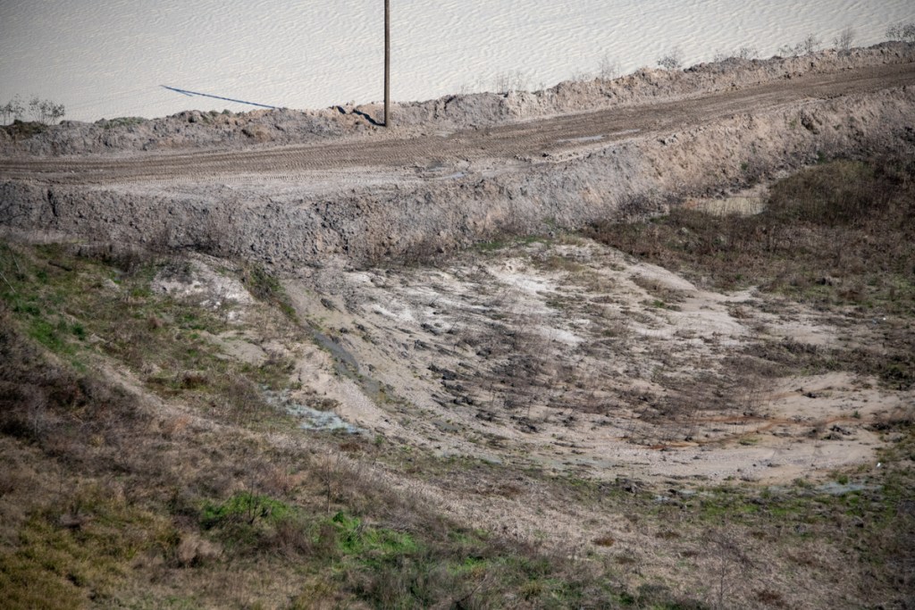
Since then, aerial photos show that LMI is building dikes higher to prevent future releases. But as the thin dikes made out of sand/silt get higher, they also get narrower. They seem designed to fail at some point.

Process waste water leaks through them into surrounding wetlands and the West Fork. To keep the dikes from failing, the mine even appears to be pumping water out of its pit into the wetlands.

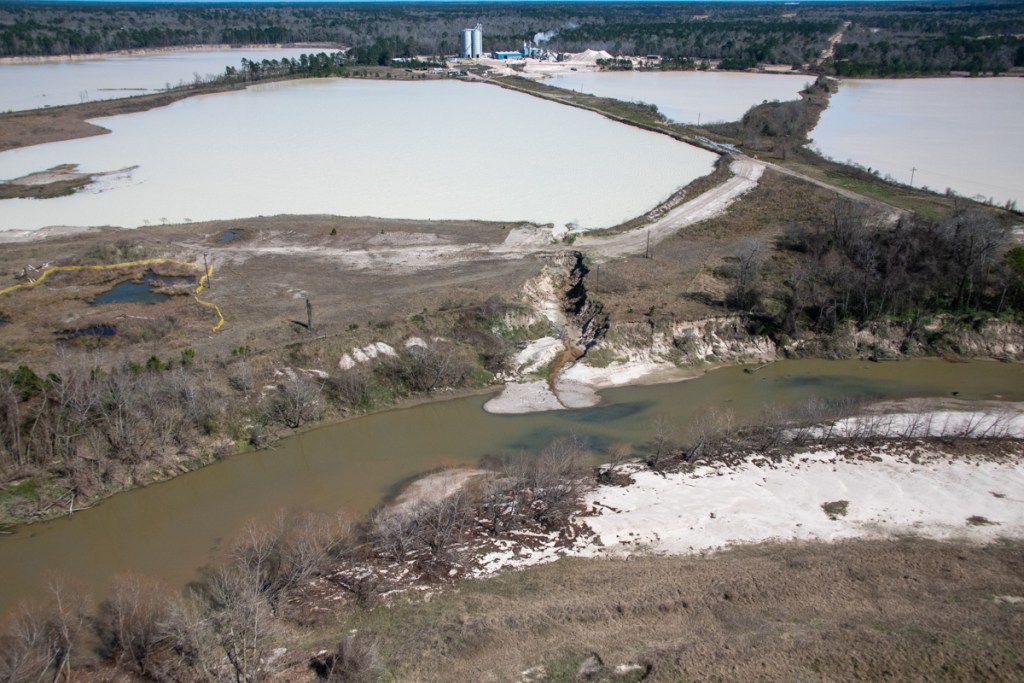
A large rain could easily overwhelm these dikes and cause another failure. As a starting point, review the satellite photo below from Google Earth. It was taken about a month after a major breach from another part of the mine. Note the perimeter road around the entire pond. It disappears in aerial photos taken a few months later.

Satellite photo from 12/1/2019 shows a drivable road around the entire eastern perimeter (right) of the LMI Moorhead mine.

Now compare that to this series of helicopter photos taken on 4/21/2020. The series starts in the upper right of the satellite photo and heads south (toward the bottom of the satellite image). This area of the mine is far from public view, except from a helicopter..

Note the difference in elevation between the pond in the mine and the pond outside of it.
Note the partially buried pipe between the two ponds. A siphon?
Looking south along the eastern perimeter. you can see how the road now disappears and the wall of the dike gets thinner.
Zooming out, you can see how the far this condition exists and why I ask the question, “Are these dikes designed to fail?”
Tracking south to the next grove of trees, you can see water leaking through the narrow dike as it approaches the top. Comparing the dike to nearby tree trunks, I estimate the dike is no more than 2-3 feet wide.

Where 56 Million Gallons Allegedly Entered River

The same condition exists on another pit at the same mine. The dike shown in the foreground is the one that the TCEQ says failed last year. Note water ponding on the narrow road. See photo below.

Note the difference in the color of the water in the pond and in the river in the photo below. The pond color has not changed during the eight months I have been documenting these sand mining operations from the air.

Same dike, photographed from a different angle, looking north. West Fork is in foreground.
A new Artavia drainage ditch in the background now funnels water from more than 2000 acres straight toward mine. The mine blames Artavia for the November discharge.

No Texas Regulations Govern Dike Construction

Unfortunately, the State of Texas has no regulations that address construction of dikes.

No standards exist for height, width, composition, compaction, or reinforcement.

I asked Ramiro Garcia, head of enforcement for the TCEQ, this question. Does Texas have regulations for sand mines that affect the width, height, slope, compaction, and materials used in perimeter dikes or barriers?

His reply: “The Industrial Stormwater Multi-Sector General Permit requires the use of pollution prevention practices that can effectively protect the water quality in receiving waters, or that are necessary for remaining in compliance with the general permit. The GP states that “the permittee shall evaluate and use appropriate measures and controls to reduce soil erosion and sedimentation in areas of the facility with demonstrated or potential soil erosion and sedimentation” (Part III.A.4(c)). There are no specific requirements for width, height, slope, compaction, or materials for dikes or barriers.

So the permittee gets to determine what’s “appropriate”!

Designed to Fail?

The lack of regulation is how we get strips of sand a couple feet wide holding back hundreds of millions of gallons of waste water. One big rain, a flood, and the wastewater buildup is gone. Conveniently!

If the TCEQ discovers an unauthorized discharge, the mine pays a “slap on the wrist” fine. They average about $800. That’s why I ask, “Are sand mine dikes designed to fail?” It seems cheaper and easier to pay the fine than build earthworks that protect the source of drinking water for 2 million people.

State Rep. Dan Huberty tried to implement effective sand mining regulations during the last legislative session. Unfortunately, most of the mining bills he sponsored died in committee. I’m using the time before the next session to document mining practices on the San Jacinto. Hopefully, we’ll be able to make a better case next year.

Posted by Bob Rehak on 5/4/2020

979 Days after Hurricane Harvey

The thoughts expressed in this post represent opinions on matters of public concern and safety. They are protected by the First Amendment of the US Constitution and the Anti-SLAPP Statute of the Great State of Texas.

Are Sand Mine Dikes Designed to Fail?

After 2.5 years of examining photos and videos of the so-called “dikes” in sand mines, I have come to believe that some are designed to fail. In some cases, mines cause them to fail.

In most cases, the “dikes” are not really dikes. They’re just the edges of pits that miners have excavated. Or roads around the pits made of sand that easily erode.

And because miners mine so close to the river, when those pits fill with water, they overflow. The resulting erosion cuts channels between the pit and the river that allow the pits to discharge a portion of their wastewater. Lake Houston and public drinking water become collateral damage.

High Cost of Flimsy Construction

After the storm, miners throw some sand in the breach and wait for it to happen again. The sand creates only the appearance of a fix.

Month after month, I’ve photographed active breaches, “patched” breaches, and scars in the landscape from older breaches. Many reopen multiple times.

Breaches are so common that, in my opinion, they may be part of some miners’ business plans.

High Cost of Silt

If discharges consisted of plain water, I might not care. But the water usually carries silt with it. Miner’s settling ponds can fill with silt which has little marketable value. Flushing it downriver solves another problem.

Miners externalize their cleanup costs by foisting them off on an unsuspecting public. That sediment clogs rivers that must be dredged to avoid flooding. It reduces the capacity of the lake. And it escalates the City’s water treatment costs.

A retired high-level Public Works manager told me he routinely investigated and found breaches at sand mines during floods. In his opinion, many of the breaches were intentional and the floods created the perfect “cover” for the illegal discharges. “Blame it on Mother Nature,” he said.

West Fork Images from February Flyover

Below, a sampling of more than 1000 images I took on 2/13/2020. The first batch shows mines on the San Jacinto West Fork between SH242 and US59. I traveled NW to SE toward 59. I’ve arranged images in the same order.

Sand mine pond and water’s path to the river (right). Pond is full to the brim and will overflow on a minor rain.
Another angle looking north toward the same breach.
West Fork is migrating toward pit on right and will soon enter it. A powerful argument for reasonable setbacks from river.
Dike erosion at Liberty Materials Mine. The TCEQ alleges this mine discharged 56 million gallons of that white gunk into the West Fork last November. This breach has been like this for months.
Another pond at the same mine. The only thing holding back another illegal discharge is a feeble road made of sand. See close up in next pic of area near poll just left of center.
Close up of road in upper left of previous photo. Note how water seeping through it is already causing road to collapse.
Silt spreading into settling pond. See also reverse shot below.
Reverse angle from previous shot, but same pond. See West Fork in background and note how road in foreground was cut by spreading silt.
Site of previous double breach at RGI mine. Note gray area in second row of dikes. Process water from the pond behind it broke into the settling pond in the foreground and from there into the West Fork. TCEQ cited owners.
Two separate ponds may have shared this same “wash” to the river (foreground). Pond in middle right is actively discharging into river. See reverse angle in next shot.
Same discharge as in previous shot. From this angle it is easier to see the active discharge.
Same breach from third angle. From this angle, you can clearly see the path and the discharge.
This pond has been discharging into the river for months. Note the difference in the color of the river water and discharge water. This indicates the discharge water is still holding silt.
Reverse shot of same breach highlights both the path and the color difference of the discharge.
This pond is leaking into a drainage channel that parallels Northpark Drive south of Oakhurst.
Former breach at Eagle mine on Sorters Road. West Fork in foreground.
Scars from previous breaches. One of these was intentional, though I’m not sure which. See video below.
Video by resident who wishes to remain anonymous shows intentional breach at the mine above.
Another scar from previous breach.
Confluence of Spring Creek (left) and West Fork San Jacinto (right). Facing west. Note color difference in water. It’s frequently visible.
Same area looking southeast toward Humble. West Fork on left.
Same area looking NE toward Kingwood. West Fork comes in from left.
Between the 59 bridge in the previous shot and this area, the Army Corps spent more than $90 million removing sediment from the West Fork. The City, County and State could spend another $35 million removing this blockage.

East Fork Images from February Flyover

Breach into Caney Creek at Triple PG sand mine was open for months and became the focus of a suit by the Attorney General. Note steepness of sides of “fix,” and erosion along side. Best Management Practices call for sloping and planting sides of dikes to reduce erosion.
Wider shot shows just how much forest was blown out in this breach, leading one to wonder whether this was caused solely by nature.
Another former breach into Caney Creek from the Triple PG mine. Only this eroding road stands between the mine and the creek.
Also at the Triple PG mine in Porter, this breach into White Oak Creek remained open for months. It, too, was the subject the Attorney General’s lawsuit. A restraining order against the mine calls for repairs to be certified by a professional engineer. This looks as though they may have tried to add concrete to the sand and stabilize it with rebar. However, note that the concrete, if that’s what it is, doesn’t rise much above the water. The road is made from eroding sand that will blow out in the next storm.
Reverse shot of same breach looking west. No concrete or rebar visible here – only rilling along steep sides of road. Rilling is the term for those vertical erosion channels.

Posted by Bob Rehak on 2/24/2020

909 Days since Hurricane Harvey and 158 since Imelda

The thoughts expressed in this post represent opinions on matters of public concern and safety. They are protected by the First Amendment of the US Constitution and the Anti-SLAPP Statute of the Great State of Texas.