Tag Archive for: 2021 hurricane season prediction

Colorado State Experts Predict Another Hurricane Season Like 2001, 2008 and 2017

Researchers at highly respected Colorado State University (CSU) issued their hurricane season forecast for 2021 last week. Like the University of Miami, AccuWeather and others, they predicted an above-average season based on sea-surface temperatures, the presence of La Niña, and historical analogs. CSU used data and models going back 40 years. Factors considered also include: where sea surface temperatures are warmer/cooler, sea level pressures, vertical wind shear levels (the change in wind direction and speed with height in the atmosphere), accumulated tropical cyclone energy, and more.

CSU Forecast Compared to Others

Here’s how CSU’s hurricane season forecast looks compared to historical averages and other predictions.

Year(s)StormsHurricanesMajor Hurricanes
1981-2010 (Old Average)1263
1991-2020 (New Average)1473
2020 Actual30136
2021 Predicted by AccuWeather16 to 207 to 103 to 5
2021 Predicted by Colorado State1784
Major Hurricanes are Cat 3 or higher with sustained winds of 111 mph or greater.

Striking Recent Parallels

According to CSU, so far, the 2021 hurricane season is exhibiting characteristics similar to 1996, 2001, 2008, 2011 and 2017. “All of our analog seasons had above-average Atlantic hurricane activity, with 1996 and 2017 being extremely active seasons,” said Phil Klotzbach, research scientist in the Department of Atmospheric Science and lead author of the CSU report.

In case you’re new to the Houston area and the significance of those bold-faced years escapes you:

  • 2001 was Tropical Storm Allison which dumped 38 inches of rain on Houston, so much that it caused flood maps to be redrawn. The storm meandered over Houston for 4 days due to slow movement and weak steering currents.
  • 2008 was Hurricane Ike which destroyed tens of thousands of homes on the Bolivar Peninsula. It killed 195 people, came ashore as a Cat 4 storm with winds of 148 miles per hour, came straight up Galveston Bay, went right over Kingwood, and knocked down so many trees that the Lake Houston Area lost power for 3 weeks. It did $38 billion in damage and ranks as the sixth costliest storm in US history.
  • 2017 was Hurricane Harvey. HCFCD’s report on the storm says it all. At the peak of Harvey, five times more water went over the Lake Houston Dam than goes over Niagra Falls on average.
Bolivar Peninsula after Hurricane Ike in 2008. Photo Courtesy of NOAA.
In 2019, NASA captured Dorian and this string of tropical cyclones lined up across the Western Hemisphere.

But 2011 was the opposite end of the spectrum. It was the driest year ever for Texas and the start of a drought that lasted through 2014.

Playing the Percentages

The CSU team predicts that 2021 hurricane season activity will be about 140 percent of the average season. By comparison, 2020 was about 170 percent. The 2020 hurricane season had six landfalling continental US hurricanes, including Category 4 Hurricane Laura which battered southwestern Louisiana.

The report also includes the probability of major hurricanes making landfall:

  • 69% for the entire U.S. coastline (average for the last century is 52%)
  • 45% for the U.S. East Coast including the Florida peninsula (average for the last century is 31%)
  • 44% for the Gulf Coast from the Florida panhandle westward to Brownsville (average for the last century is 30%)
  • 58% for the Caribbean (average for the last century is 42%)

Keep your fingers crossed and make sure you’re prepared. It only takes one storm to make your life miserable if you are not prepared. And remember, Allison happened on June 4th…just three days after the start of hurricane season.

Posted by Bob Rehak on 4/10/2021 based on a report by Colorado State University

1320 Days since Hurricane Harvey

Another Above-Average Hurricane Season Predicted

This is the time of year when meteorologists start predicting how many hurricanes we will experience in the Atlantic Basin. Frank Billingsley at Click2Houston.com issued his prediction for an above-average hurricane season Friday. He also predicts that other meteorologists will predict the same. Here’s why.

Official Averages Out of Date

The official window used to calculate the average number of storms has been 1981 to 2010. But when Brian McNoldy of the University of Miami looked at the more recent 30 years from 1991 to 2020, he found an increase in the number of storms. Also, AccuWeather has already come out with its prediction, showing a substantial increase.

Year(s)StormsHurricanesMajor Hurricanes
1981-2010 (Old Average)1263
1991-2020 (New Average)1473
2020 Actual30136
2021 Predicted by AccuWeather16 to 207 to 103 to 5
Sources: Brian McNoldy, AccuWeather, NHC

Other Contributing Factors

Sea-Surface Temperatures

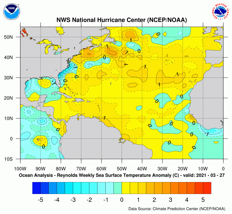
Sea-surface temperatures are slightly above normal for this time of year. Despite the polar outbreak in February which cooled the Gulf somewhat, the Caribbean and Atlantic remain higher than average. See anomaly map below from NOAA’s Climate Prediction Center.

Seven day average as of 4/3/2021
La Niña

Billingsley’s prediction also takes into account La Niña, which is part of ENSO (El Niño Southern Oscillation).

NOAA describes El Niño and La Niña as the warm and cool phases of a recurring climate pattern across the tropical Pacific. The pattern can shift back and forth irregularly every two to seven years, and each phase triggers predictable disruptions of temperature, precipitation and winds.

The El Niño phase usually means fewer hurricanes in the Atlantic.

Typical influence of El Niño on Pacific and Atlantic seasonal hurricane activity. Map by NOAA Climate.gov, based on originals by Gerry Bell.

The La Niña phase usually means more hurricanes in The Atlantic.

Typical influence of La Niña on Pacific and Atlantic seasonal hurricane activity. Map by NOAA Climate.gov, based on originals by Gerry Bell.

Why? In short, the warm, wet air of El Niño in the tropical Pacific produces stronger vertical wind sheer which discourages hurricane formation in the Atlantic. The cool, dry air of La Niña produces less wind sheer which lets hurricanes form more easily.

National Hurricane Center

The real question is: How long will La Niña last? La Niña was strong last year. That meant one of the busiest hurricane seasons ever. (See table above.) But will it fade by the start of this hurricane season or the end? The Texas Water Development Board predicted it would begin to fade after this month. But some models show it lasting through the end of the year.

Bermuda High

AccuWeather predicts three to five hurricanes will make a direct hit on the United States this year. That’s partially due to another factor – the position of the Bermuda High. A weak Bermuda High means storms forming in the Atlantic would most likely aim at the Eastern Seaboard as opposed to coming into the Gulf.

Bottom line, “Be prepared. Anyone who has been through a hurricane can tell you it only takes one.”

Frank Billingsley, Click2Houston.com

Valuable Resources During Hurricane Season

For the full AccuWeather forecast, click here.

Colorado State University’s hurricane forecast comes out next week. It’s one of the most respected in the world.

During the season, the National Hurricane Center provides the most frequent updates of storm activities. They will start issuing tropical updates on May 15. And their reports will have more features than ever this year. See the list of new features including storm surge inundation values, weather forecasts for “blue-water” mariners, wave heights, cumulative maximum winds over 5-days, and more.

Posted by Bob Rehak on 4/3/2021 based on information from Click2Houston, AccuWeather, and NOAA

1313 days since Hurricane Harvey