
Three Named Storms in Atlantic in Two Days, Could Get Fourth
8/21/23 (9 AM CDT) – Three named storms have formed in the Atlantic in two days and we will likely get fourth (in the Gulf of Mexico) today or tomorrow.
Tropical storms Emily and Gert formed in the Atlantic yesterday (8/20/23). Gert formed overnight. And a fourth disturbance barreling across the Gulf of Mexico toward the lower Texas Coast could reach tropical storm intensity today or tomorrow, according to the National Hurricane Center (NHC).

2023 Summary Compared to 30-Year Average
So far this year, the Atlantic Basin has had:
- An unnamed sub-tropical storm in January, that was later determined to have 70 mph max winds
- Tropical Storms Arlene, Bret and Cindy in June
- Hurricane Don in July
- Emily, Franklin and Gert in August
If the disturbance currently in the Gulf turns into a named storm, it will become Harold – the ninth storm of the year to reach tropical storm intensity.
Normally, by this week in the hurricane season, the Atlantic Basin has five named storms. See the table below from the NHC’s Climatology page.
| Progress of the average Atlantic season (1991-2020). Date upon which the following number of events would normally have occurred. | |||
| Number | Named systems | Hurricanes | Major Hurricanes |
| 1 | Jun 20 | Aug 11 | Sep 1 |
| 2 | Jul 17 | Aug 26 | Sep 19 |
| 3 | Aug 3 | Sep 7 | Oct 28 |
| 4 | Aug 15 | Sep 16 | – |
| 5 | Aug 22 | Sep 28 | – |
| 6 | Aug 29 | Oct 15 | – |
| 7 | Sep 3 | Nov 15 | – |
| 8 | Sep 9 | – | – |
| 9 | Sep 16 | – | – |
| 10 | Sep 22 | – | – |
| 11 | Oct 2 | – | – |
| 12 | Oct 11 | – | – |
| 13 | Oct 25 | – | – |
| 14 | Nov 19 | – | – |
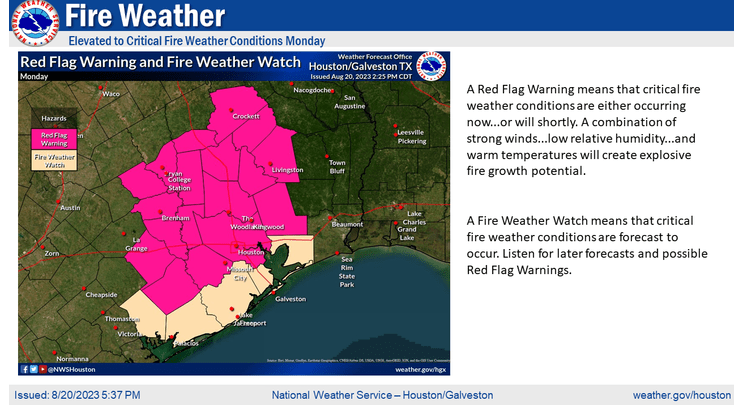
Greatest Threat to Houston is Fire
None of the current disturbances in the Gulf, Caribbean or Atlantic represent a threat to Houston.
The closest storm to Houston is south of Mississippi as of 9AM Tuesday morning. It will miss the upper Texas Coast and likely come ashore between Corpus Christi and Brownsville tomorrow.
NHC says that showers and thunderstorms are showing signs of organization and banding. Environmental conditions appear conducive for development. And a tropical depression or tropical storm is likely to form before it reaches the coastline on Tuesday. Formation chance is high…80 percent.
The greatest threat to the Houston area is not rain or flooding; north of I-10, we should see only about a tenth of an inch from the storm. But hot, dry conditions combined with a long-term drought have created critical fire weather conditions. A burn ban is in effect. High winds associated with the storm could spread fire quickly. So be careful. Several fires are already burning in other parts of East Texas.
Discussion of Other Disturbances
Unnamed Storm off African Coast
NHC gives the other unnamed storm off the coast of Africa a formation chance of 70% in the next 7 days.
Emily
Emily will also turn north. Its intensity will lessen into a tropical depression by Tuesday morning.
Franklin
NHC predicts Franklin will turn north and cross Puerto Rico, the Dominican Republic and Haiti through the middle of the week. It could produce heavy rainfall; life-threatening flash and urban flooding; and mudslides through Wednesday.
Gert
Gert is quickly unraveling. NHC expects to downgrade it into a tropical depression by Monday at 2PM.
A Record?
Is three or four named storms in two or three days a record? According to Harris County Meteorologist Jeff Lindner, it’s not. The record is closer to five or six at one time, he says. Regardless, tropical activity is heating up. The peak of hurricane season is still three weeks away – September 10th. It looks like earlier predictions of an above-average season were accurate.
In the meantime, watch out for that heat! Here’s a summary put together by Lindner of record highs on 8/20/23.
College Station: 112 (tied all time record high from 9-4-2000, broke the all-time August record high of 110 from 8-17-1903, and shattered the daily record high of 107)
- BUSH IAH: 108 (broke the daily record high of 107 from 1909). This is only the 5th time since the 1880’s that Houston has reached 108. 1 degree shy of the all-time record high of 109.
- Hobby: 107 (broke the daily record high of 101 in 1999).
- Galveston: 97 (tied record high from 1995)
- Huntsville: 112 (shattered the daily record high of 106 from 1909)
- Madisonville: 108 (broke daily record high of 105 from 1948)
- Sugar Land: 107 (broke daily record of 101 from 2018)
- Conroe: 109 (tied all time record high from 2000 and 1925)
- Tomball: 110 (shattered daily record of 101 from 1999) All time record high surpassing 108 in 2000
- Wharton: 106 (broke daily record of 100 from 1911)
- Brenham: 108 (broke daily record of 105 from 1948)
Posted by Bob Rehak on 8/21/23
2183 Days since Hurricane Harvey

