
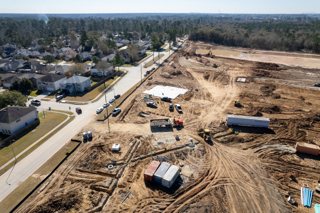
Dirt Excavated from Woodridge Being Used to Build Up Laurel Springs RV Resort
Sprint Sand & Clay, the company hired by Harris County Flood Control to excavate 500,000 cubic yards of dirt from Woodridge Village, began hauling some of it to the controversial Laurel Springs RV Resort near Lakewood Cove this morning.
Wake-Up Calls
My phone started blowing up before breakfast with dozens of complaints about Sprint truck traffic. So, I began investigating. I first went to the Woodridge Village site. Drone photos and on-the-ground observations revealed that Sprint was indeed hauling dirt from the Woodridge Village excavation site.

I followed one of the trucks all the way to Laurel Springs Lane where I observed it dumping its load. Along the way and at each end, I saw many more Sprint trucks – up to four at a time. There was a veritable parade of dump trucks making round trips along Woodland Hills Drive, Kingwood Drive, Chestnut Ridge, and Laurel Springs Lane.

Will Storm Drains Be Adequate?

In the shot above, note the ponding water from 0.2 inches of rain more than a week ago. The contractor’s Stormwater Pollution Prevention Plan describes this soil as “silty sand” to a depth of 18 inches (Page 18).
They may want to recheck that before installing more storm drains.
Other Issues Noted Today


Good News/Bad News
The start of serious excavation at Woodridge Village comes as welcome news to the people of Elm Grove and North Kingwood Forest who flooded twice in 2019. However, it’s equally worrisome to the people of Forest Cove and Lakewood Cove. Many expressed concerns about potential flooding.
Risks from Building Up Land
Should existing residents be concerned about that? Yes, was the answer I got from one respected hydrologist who spoke on condition of anonymity. He likened the built-up area to a berm and said that “You don’t want a berm to stop overland sheet flow.”
The elevation survey shown below comes from the RV park’s Stormwater Pollution Prevention Plan. It shows that the land naturally slopes from northeast to southwest. Building up the RV property would definitely prevent water from the NE from flowing in that direction. Sheet flow would divert south along Laurel Springs and put an evacuation route at risk.

East to west along the southern boundary, the elevation drops from 67 feet at Laurel Springs to 61 feet near the railroad tracks.
Another risk is that sheet flow with nowhere else to go could back up Lakewood Cove storm sewers at the same time that the RV park is trying to pump water into them to compensate for its undersized detention pond.
Texas Water Code
Chapter 11.086 of the Texas Water Code covers situations like these.
If someone sustains water damage on their property due to a neighbor’s property, questions as to who may be liable may arise. Surface water runoff — most often caused by excess rainwater — is the common culprit. Texas law holds landowners responsible for damage to neighboring property due to diversion of surface water.
If you find the legal wording in the water code difficult to understand, visit this Texas State Law Library page for resources written in plainer English.
SWPPP Plan Good for Laugh-Out-Loud Moment
I received a copy of the RV Park’s SWPPP plan today from the TCEQ. Parts of it made me laugh out loud. For instance, the section about “Receiving Waters, Wetlands and Special Aquatic Sites” said:
“No existing wetlands or other special aquatic sites have been identified at or near this site [Emphasis added].”
Page 18 of Laurel Springs RV Park SWPPP prepared by Construction Eco Services
Obviously, they didn’t glance across the southern property line or consult the National Wetlands Database. I can’t wait to read the rest of this plan to uncover more gems.

Posted by Bob Rehak on 2/9/22
1625 Days since Hurricane Harvey


