
Tuesday AM Rain Outlook: Heating Up, Flash Flood Watch Remains in Effect
A Flash Flood Watch remains in effect through Thursday morning.
A serious flash flood threat remains in place over all of SE TX and much of eastern TX into Thursday.
According to Harris County Meteorologist Jeff Lindner, “After the storms from yesterday, deeper moisture has been pushed toward the coastline and offshore, but will rapidly return today.
A slow moving line of thunderstorms moved through the area on Monday producing generally 1 to 4 inches of rain across the area with localized areas of 6 to 8 inches in Liberty, eastern Montgomery, and northeastern Harris County.
The National Weather Service says that a lull in the precipitation occurred overnight, but the chance for heavy rainfall returns this morning as an upper level disturbance moves through the area. An additional 1 to 3 inches of rain with locally higher totals will be possible today. A stronger upper level disturbance will bring yet another round of heavy rain Wednesday into Thursday with additional rainfall totals of 2 to 4 inches of rain with again locally higher totals possible. Storm total rainfall by Thursday morning will average between 4 and 8 inches with isolated totals possibly exceeding 10 inches. The flood threat will be strongly dependent on where the rain falls and how quickly it falls.
Today-Tonight
Scattered showers and thunderstorms will develop with heating today. But it continues to be hard to pinpoint where storms may develop. By this afternoon, storms will likely begin to approach southeast Texas from the west and northwest. They may also possibly approach again from the northeast or north into the evening and overnight hours. See the satellite photo below.

Wednesday-Early Thursday
An upper level trough will transport extreme moisture into the region along with the jet stream. Models many possible scenarios from slow moving lines to quickly approaching complexes from the west. Regardless, the overall pattern favors heavy rainfall, flash flooding, and severe weather.
Rainfall Amounts
Lindner expects additional rainfall totals of 4-6 inches over the next 48 hours with isolated totals of 10-12 inches. Much of what falls is going to come in short intense bursts of rainfall, he says, and not spread out evenly over time.
The National Weather Service gives our eastern and northern counties a moderate risk of flash flooding today. The risk area should enlarge tomorrow across the entire region.


The orange areas indicate moderate risk. That means a 20-50% chance of excessive rainfall.
River, Stream Report
Run-off continues across the region this morning from the heavy rainfall yesterday. Cedar Bayou upstream of US 90 remains high, but has crested and is slowly falling. Spring Creek is rising as upstream run-off from northern Waller County moves into the mainstem of the creek. Not flooding is expected, but the creek will be elevated through the day. West Fork of the San Jacinto River is rising due to inflow from Spring and Cypress Creeks and will crest later this morning.
Both the SJRA and Coastal Water Authority are releasing water from Lake Conroe and Lake Houston preemptively. However, both lakes remain a few inches above their normal levels at the moment.
Additional rainfall over the next few days will quickly run-off resulting in new rises on area creeks, bayous, and rivers. Some flooding of creeks, bayous, and rivers will be possible.
Forecasted Rainfall Next 72 Hours
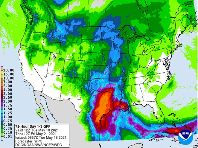
Photo of White Oak Creek from Yesterday

As I write this, the rain has started already this morning. Let’s hope the rain is spread out enough that the creeks can handle it. As predicted, so far it’s coming down in sporadic bursts mixed with light drizzle.
Posted by Bob Rehak on 5/18/2021 based on information provided by the NWS, HCFCD, and Donald Brown
1358 Days since Hurricane Harvey


