Rain Forecast This Week
Jeff Lindner, Harris County Meteorologist but put this notice thus morning. He said wet weather will persist until mid week.
Slow-Moving Cold Front Stalls Out
A slow-moving cold front currently extends from Longview to north of Austin and is creeping southward. Ahead of this boundary a warm and moist air mass covers all of SE TX this morning. Meanwhile, north of the boundary a colder and somewhat drier air mass is in place.
Radar is fairly calm this morning with a couple of lines of showers lifting north over the region in the warm air advection pattern in place.
Surface cold front will move to near a Madisonville-to-College-Station line later this morning and then likely stall in that region today. Focus for rainfall today will be mainly across the northern half of the region closest to the front. Rainfall amounts today could average 1-2 inches north of HWY 105 as another upper level disturbance approaches from the WSW and interacts with the slow moving front.
Front Pushes South Tonight
Front will get another push this evening and likely progress southward toward the coast tonight. With the afternoon and evening short wave disturbance moving off to the ENE expect a lull in any heavier rains by late evening across the northern portions of the area.
Mainly light showers will impact the southern portions of the area this evening and overnight as the surface front stalls near the coast.
Tuesday Front Lifts Back North
On Tuesday the surface front begins lifting back northward as a warm front with a continued chance of showers over the area.
A strong upper level storm system currently digging into NW Mexico will begin to move slowly eastward and toward TX late Tuesday into Wednesday. This will result in the formation of a surface low pressure system over the coastal bend of TX Tuesday night which then moves ENE/NE across SE TX Wednesday.
Showers and thunderstorms will be likely in this period with some heavy rainfall possible.
Clearing Late in Week
This surface low will be strong enough to finally push a stronger front through the region and clear the area out for at least a couple of days before clouds and rain chances return for the weekend.
Yo-Yo Temperatures
Temperatures will be all over the place with the surface front stalling and then creeping across the area. Ahead of the front temperatures will be in the 70’s and then fall into the 60’s and possibly 50’s behind the boundary.
Rainfall 1-4 Inches, Highest to North
Rainfall Amounts:
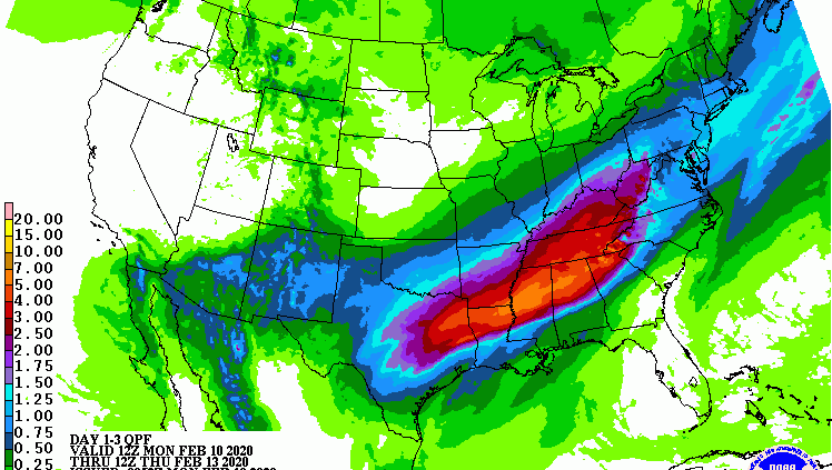
Fairly tight rainfall gradient will setup across SE TX over the next 72 hours with much of the rainfall occurring north of HWY 105 and much lower amounts near the coast.
Storm total rainfall amounts through Thursday morning will likely average 1-2 inches over much of the region north of I-10 and 3-4 inches in the Lake Livingston area.
South of I-10 amounts of .50-1.0 inch will be possible. While the drought monitor shows dry conditions over much of the area, the time of year combined with lack of any vegetation growth and the widespread nature of the expected rains suggest rises on area creeks and rivers will be likely.
Highest impacted watersheds look to be the mainstem and tributaries of the Trinity River and the San Jacinto basin.
Currently predicted amounts are spread out enough to preclude any forecast to reach flood stage, but we will need to watch rainfall trends today and again on Tuesday especially north of HWY 105.
Should rainfall totals begin to pile up in our NE counties (Polk, Trinity, Houston, San Jacinto) a flash flood watch could be required for those areas.
Excessive Rainfall Outlook (Monday):

Excessive Rainfall Outlook (Tuesday):

Day 1-3 Forecast Rainfall Amounts:

Posted by Bob Rehak on 2/10/2020 with thanks to Jeff Lindner
895 Days since Hurricane Harvey


